Home › Navigation

 MX
MX
 USen-US
 CAen-CA
 BRpt-BR
 AUen-AUMXes-MX
 TRen-GB
 CLes-MX
 RUru
RUru PEes-MX
 COes-MX
 CNzh-Hans-CN
 MYen-GB
 KHen-GB
 ZAen-GB
 THen-GB
 GBen-GB
 ECes-MX
 IDen-GB
 SAen-GB
 CHde-CH
 GTes-MX
 JPja
JPja UAen-GB
 AEen-GB
 BOes-MX
 CRes-MX
 KRko
KRko PHen-GB
 ARes-MX
 ILen-GB
 NOen-GB
 HKzh-Hant-HK
 INen-GB
 NAen-GB
 OMen-GB
 SVes-MX
 AMen-GB
 DOes-MX
 DZen-GB
 JOen-GB
 KWen-GB
 KZen-GB
 LBen-GB
 MNen-GB
 NIes-MX
 NZen-AU
 PAes-MX
 PKen-GB
 QAen-GB
 SGen-GB
 SNen-GB
 TMen-GB
 TWzh-Hant-TW
 TZen-GB
 VEes-MX
 VNen-GB
 AFen-GB
 AGen-GB
 AIen-GB
 ALen-GB
 AOen-GB
 AZen-GB
 BAen-GB
 BBen-GB
 BFen-GB
 BHen-GB
 BJen-GB
 BMen-GB
 BNen-GB
 BSen-GB
 BTen-GB
 BWen-GB
 BYen-GB
 BZen-GB
 CDen-GB
 CGen-GB
 CIfr-FR
 CMfr-FR
 CVen-GB
 DMen-GB
 EGen-GB
 FJen-GB
 FMen-GB
 GAfr-FR
 GDen-GB
 GEen-GB
 GHen-GB
 GMen-GB
 GWen-GB
 GYen-GB
 HNes-MX
 IQen-GB
 ISen-GB
 JMen-GB
 KEen-GB
 KGen-GB
 KNen-GB
 KYen-GB
 LAen-GB
 LCen-GB
 LKen-GB
 LRen-GB
 LYen-GB
 MAen-GB
 MDen-GB
 MEen-GB
 MGen-GB
 MKen-GB
 MLen-GB
 MMen-GB
 MOzh-Hant-HK
 MRen-GB
 MSen-GB
 MUen-GB
 MVen-GB
 MWen-GB
 MZen-GB
 NEen-GB
 NGen-GB
 NPen-GB
 NRen-GB
 PGen-GB
 PWen-GB
 PYes-MX
 RSen-GB
 RWen-GB
 SBen-GB
 SCen-GB
 SLen-GB
 SRen-GB
 STen-GB
 SZen-GB
 TCen-GB
 TDen-GB
 TJen-GB
 TNen-GB
 TOen-GB
 TTen-GB
 UGen-GB
 UYen-GB
 UZen-GB
 VCen-GB
 VGen-GB
 VUen-GB
 XKen-GB
 YEen-GB
 ZMen-GB
 ZWen-GB
 ATNot Available
 BENot Available
 BGNot Available
 CYNot Available
 CZNot Available
 DENot Available
 DKNot Available
 EENot Available
 ESNot Available
 FINot Available
 FRNot Available
 GRNot Available
 HRNot Available
 HUNot Available
 IENot Available
 ITNot Available
 LTNot Available
 LUNot Available
 LVNot Available
 MTNot Available
 NLNot Available
 PLNot Available
 PTNot Available
 RONot Available
 SENot Available
 SINot Available
 SKNot Available
148 of 175 storefronts
Content in es-MX
Content in es-MX
Information
Apple ID287909017
Bundle IDcom.garafa.GPSKit
SellerSeller
Min iOS9.0
Min macOS11.0
Device familiesiphone, ipod
Released2019-02-11
Copyright© Garafa, LLC
WebsiteLink ↗
Preview 1 platform
iPhone 5 images


What’s New Version 8.0.4
This update from Apple will improve the functionality of this app. No new features are included.
Bug fixes
Previous Release:
- updated to 64 bit
- updated for new screen sizes
- fixed weather stations
- fixed sharing
Description
- TIME Magazine’s 15 Fantastic Gadgets
“Perfect for hiking or mountain biking.”
- TUAW.com
“The GPS Kit app... has a number of excellent outdoor uses, especially [for] hiking, biking or geocaching.”
- NBC’s ‘The Browser’ Radio Show
“Most beneficial for adventure-type guys.”
_________________________________________________________
Top-of-the-line GPS system for adventurers and professionals in the great outdoors.
Designed for outdoor activities such as:
hiking, hunting, camping, skiing, cycling, geocaching, mountain biking, motorcycling, off-roading, fishing, and other romping in or out of the backcountry—ANYWHERE IN THE WORLD.
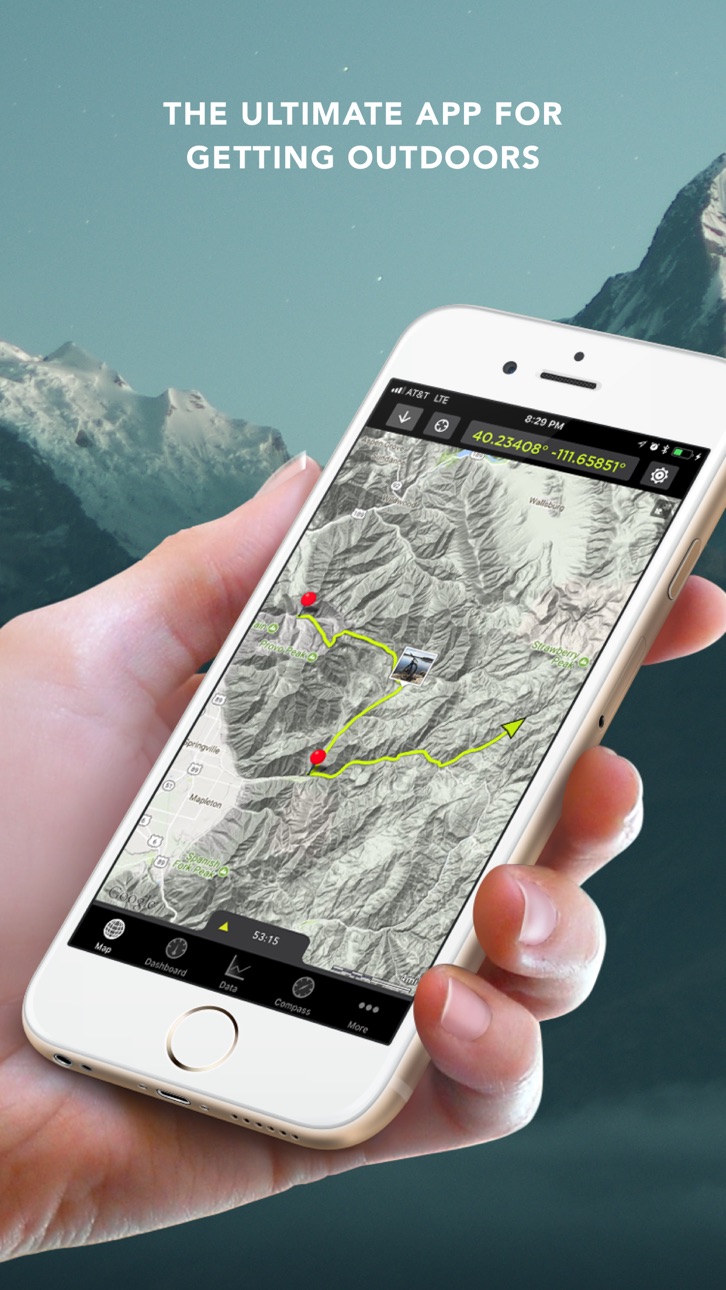
GPS Kit is a full-featured GPS system for the iPhone that combines all the functionality of expensive handheld units with the power of wireless technology. Using advanced technology optimized for the iPhone, GPS Kit offers a superbly easy-to-use system that puts data from a wide range of sensors at your fingertips.
Highest Quality Mapping
- Fastest maps in the App Store
- Smooth, elegant interaction
- Offline Mode enables use out of cell range
- No data connection required if map is cached
- Use your own map sources
Simple, Powerful Data Handling
- Mail links for Google Earth & map viewing
- Full-color thumbnails of data sets
- Group tracks and waypoints together
- Most options for export and import of data
- Open KML, KMZ, & GPX from Mail & Safari
- Attach KML & GPX files to email
- Export GPX & KML through iTunes
- Share your adventures on Facebook and Twitter
Powerful Waypoints
- Add photos and notes to waypoints
- Drag map to reposition as coordinates update
- UTM, USNG, MGRS
- Long-press to quickly drop a waypoint
- Navigate to waypoints using compass
- Magnetic compass (3GS, 4, iPad)
- Option to use current travel direction on compass
- See distance to waypoint update in real-time
Weather Stations (U.S. Only)
- Create "weather stations" to get point forecasts
- Get data specific to your fishing hole, ski tour, etc.
- Data provided by the National Weather Service
- Unlimited stations
Intelligent Data Collection
- Uses maximum GPS accuracy
- Real satellite positioning even without cell signal
- Auto-segmentation of tracks for clean tracks
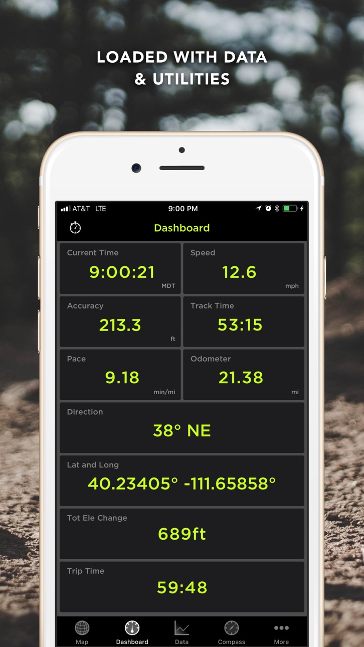
Fully Customizable Dashboard
- Gorgeous high contrast display
- Huge variety of parameters and units
- Time, Trip Time, Track Time
- Elevation Change
- Formatted Position (Lat/Lng, UTM, MGRS, USNG)
- Accuracy, Speed, Odometer, Avg Speed
- Max Speed, Pace, Avg. Pace
- Moving Time, Stopped Time, Direction
- 3-Axis Inclinometer and Glide Ratio
- Customizable cell on map
Loaded with Related Utilities
- Elevation and speed graphs
- On-map tracking controls and timer
- On-map ruler
- Multi-touch area measurements
* Use of "Squawk!" requires an Internet connection and extended use may adversely impact battery life
Continued use of GPS running in the background can dramatically decrease battery life
Accessibility
ipadiphonemacrealityDevicetvoswatch
Version history 25 versions
Build 823516171v8.0.42017-09-16 19:55:47
This update from Apple will improve the functionality of this app. No new features are included.
Bug fixes
Previous Release:
- updated to 64 bit
- updated for new screen sizes
- fixed weather stations
- fixed sharing
Build 823434636v8.02017-08-30 14:45:35
- updated to 64 bit
- updated for modern screen sizes
- fixed weather stations
- fixed sharing
Build 295602654v7.0.12014-01-15 02:28:22
Full screen bug fixed.
Map details bug fixed.
7.0 - All new update for iOS 7!
Build 209892638v7.02013-12-23 18:03:26
All new update for iOS 7!
Build 16416641v6.62013-08-29 20:27:00
- Bug fixes
Build 14226034v6.52013-02-25 16:04:38
Elevation Correction - You can now lookup the elevation for a whole track or a waypoint. Great for outdoor activities where you are are on the ground and want to keep track of vertical.
Bug Fixes - Fixed issue where GPS would turn off in the middle of a track for devices running iOS 6 or newer.
Build 11671006v6.42012-11-06 22:23:22
- Updated for iOS 6
- 4" screen support
Build 7224853v6.32012-04-04 16:38:03
- Full-screen map option
- Bug fixes
Build 6145687v6.22012-02-13 17:05:08
Fix for gpx file exporting
Fix for sharing via twitter
Build 5868788v6.12012-01-19 00:17:23
- Integration with our new app "Track Editor" to make editing your tracks a seamless experience
- Faster stats updating
- Faster elevation graph
- Allow bigger cache sessions for advanced users
- Other fixes and improvements
Build 4822813v6.02011-11-21 21:12:12
New Snow Sports Additions!
❄ Ski/Snowboard runs analysis
❄ Separate uphill and downhill stats
❄ Vertical, speed, slope, distance
Other Advanced Features:
✳ Color by speed and elevation are back!
✳ Color by distance/time
✳ Google Earth 3D track playback
✳ Awesome "Heli cam" GE 3D playback
Also:
• "Map" shortcut button for Squawk! friends
• Quick picture mode (enable in system settings)
• Offline documentation
• Fixed thumbnail loading issues
Build 4693161v5.82011-11-01 15:36:27
- export kmz files with all photos and notes included
- gpx route import
- improved gpx importing
- new user guide
- iOS 5 required that we changed the way background tracking works. Background tracking is always enabled. Every time the app goes into the background while you are tracking a warning is displayed. This warning can be turned off in the map settings.
- fixed adding note crash
- fixed black screen issue
Build 4439872v5.72011-10-17 16:54:14
-iOS 5 compliance
-Facebook feature fixed
-GIS products information in More Tab
-Improved map caching
-Added switch for keeping Squawk on in the background independent of tracking settings.
Build 4007043v5.62011-08-09 17:22:32
- All new offline map system with rectangular, circular, and free draw regions
- Better handling of maps while offline
- Added an option to always continue tracking while in the background
- Fixed "Loading Track" bug
- Fixed image problem where white bar would appear
- Improved track controls while acquiring GPS signal
- Improved use of external GPS units
Build 3851068v5.52011-06-28 19:29:06
Added Google Hybrid Maps!
Geo-tagged Photos
Import GPX data from Geocaching.com
Fixed Google Terrain Issue
Improved KML Parsing
Various Bug Fixes
Build 3693895v5.42011-05-16 16:28:49
- Geocodes photos when saved to the iPhone Album (iOS 4.1 and later)
-Fixed bug to allow users with iOS 3.x to use the app
- Other smaller bug fixes
- Three finger tap the map screen to see names of all waypoints currently on the map.
Build 3562573v5.32011-04-11 15:09:19
- Import kml and gpx files using iTunes import.
- Events can be sorted by date, name, or distance from current location.
- Satellite map issues are fixed.
Build 3402746v5.22011-03-02 16:52:19
Introducing Squawk!
- Much more stable replacement of Radar
- Friends
- Located on the tab bar for quicker use
- Much anticipated offline features
- Offline chat with Push Notifications
- Load friends' last position & track even when they are offline
- Web Viewer (no iPhone needed to view! Even works on other mobile platforms such as Android)
Other features:
- Customizable tab bar
- Improved data tab performance
- Fixed Data tab crash
Build 3321987v5.12011-01-15 03:25:51
Improved Tracking
New in 5.0:
→ Weather stations! Drop a virtual weather station at your favorite fishing hole, skiing route, or camping spot and get hourly forecasts specific to that spot right from the source! (NWS digital forecast--U.S. Only)
→ New setting to decide whether to use the magnetic or GPS compass based on how fast you are moving.
→ Added smooth object shrinking in map to keep clutter down
→ Two-finger tap to zoom out
→ Improved startup time
→ Improved smartness of tracking
→ Improved graph elevation filtering
→ Improved stability in data tab (especially with very large tracks)
→ Improved startup time
→ Improved waypoint compass
Build 3155525v5.02010-12-10 04:26:45
Added/Improved
→ Weather stations! Drop a virtual weather station at your favorite fishing hole, skiing route, or camping spot and get hourly forecasts specific to that spot right from the source! (NWS digital forecast--U.S. Only)
→ New setting to decide whether to use the magnetic or GPS compass based on how fast you are moving.
→ Added smooth object shrinking in map to keep clutter down
→ Two-finger tap to zoom out
→ Improved startup time
→ Improved smartness of tracking
→ Improved graph elevation filtering
→ Improved stability in data tab (especially with very large tracks)
→ Improved startup time
→ Improved waypoint compass
Fixed:
→ Photos from library no longer create duplicates
→ Fixed bugs in dashboard
→ Fixed bug in long chat messages
→ Fixed bug where same point publishes to Facebook
Build 3071364v4.12010-11-05 18:08:29
Added
→ Photo Waypoints
→ Drag and place waypoints
→ Add Description to waypoints
→ Facebook sharing of data sets
→ Twitter sharing of data sets
→ Data list thumbnails
→ Data list show-on-map indicator
→ Waypoint email/open in maps
→ Glide Ratio
→ Quicker startup time
→ KML import
→ Video How-To section
→ Proximity Sensor is back
→ And More!
Fixed:
→ Crash with UTM
→ Min elevation and total descent
→ Color selection bug
→ Import from mail bug on iPad
→ Export cancel button
Build 3035706v4.02010-10-09 23:31:49
iOS 4 optimized
New track timer controls for timed outings
New & improved map engine & caching
Customizable map tiles
Improved track drawing
Long press to create waypoint on map
Delete waypoint from map
Double-tap to zoom
Inclinometer
Improved Radar technology
Turn data set visibility on/off
Share & import GPX & KML via email
Optional background tracking
Tracks can be grouped with waypoints
Improved retina interface
Build 2494303v3.52010-03-28 23:13:52
Share your location with other GPS Kit users in real-time. Great for following or meeting up. You are going to love it. Its called Radar and you can turn it on in the map settings.
More intuitive starting screen.
Latitude and Longitude are displayed together on the dashboard.
Total Elevation Gain and Descent displays.
Rotate phone in graph view for larger graph.
Other performance improvements and bug fixes.
Build 2201602v3.42009-12-18 00:29:38
As requested: you can now turn track coloring off and you can color tracks by elevation
Track graphs either by elevation or speed.
Magnetic compass now turns off when you go more than 20 mph
Other performance increases and bug fixes.
Build 1949492v3.32009-10-13 18:00:40
- tracks now colored by speed
- new languages: Italian, German, and French
- measure area using four fingers in measure mode
- fixed low power mode to get a trackable point every time the gps chip turns back on
- new look through out app
- added reset track and new track to dashboard settings
- option to turn tracking back on when adding a new track
- separate tab for compass
- general program optimizations and bug fixes
Price history by region
Currency
Show
Columns
Search
Availability 148 of 175 storefronts
| Region | Language | Price | Ratings | Avg | Version |
|---|---|---|---|---|---|
| US | en-US | USD 9.99 | 360 | 4.2 | 8.0.4 |
| CA | en-CA | CAD 12.99 | 101 | 3.9 | 8.0.4 |
| BR | pt-BR | BRL 59.9 | 90 | 4.3 | 8.0.4 |
| AU | en-AU | AUD 14.99 | 59 | 4.2 | 8.0.4 |
| MX | es-MX | MXN 199 | 51 | 4.4 | 8.0.4 |
| TR | en-GB | TRY 499.99 | 39 | 3.6 | 8.0.4 |
| CL | es-MX | CLP 9990 | 32 | 4.0 | 8.0.4 |
| RU | ru | RUB 899 | 24 | 4.0 | 8.0.4 |
| PE | es-MX | PEN 44.9 | 21 | 4.6 | 8.0.4 |
| CO | es-MX | COP 49900 | 15 | 4.1 | 8.0.4 |
| CN | zh-Hans-CN | CNY 68 | 12 | 4.2 | 8.0.4 |
| MY | en-GB | MYR 49.9 | 12 | 4.3 | 8.0.4 |
| KH | en-GB | USD 9.99 | 10 | 3.9 | 8.0.4 |
| ZA | en-GB | ZAR 199.99 | 10 | 4.3 | 8.0.4 |
| TH | en-GB | THB 399 | 9 | 4.4 | 8.0.4 |
| GB | en-GB | GBP 9.99 | 8 | 3.8 | 8.0.4 |
| EC | es-MX | USD 9.99 | 7 | 4.4 | 8.0.4 |
| ID | en-GB | IDR 169000 | 7 | 4.9 | 8.0.4 |
| SA | en-GB | SAR 39.99 | 7 | 4.1 | 8.0.4 |
| CH | de-CH | CHF 9 | 5 | 4.2 | 8.0.4 |
| GT | es-MX | USD 9.99 | 5 | 4.8 | 8.0.4 |
| JP | ja | JPY 1500 | 5 | 5.0 | 8.0.4 |
| UA | en-GB | USD 11.99 | 5 | 4.8 | 8.0.4 |
| AE | en-GB | AED 39.99 | 4 | 3.3 | 8.0.4 |
| BO | es-MX | USD 9.99 | 4 | 3.8 | 8.0.4 |
| CR | es-MX | USD 9.99 | 4 | 5.0 | 8.0.4 |
| KR | ko | KRW 17000 | 4 | 5.0 | 8.0.4 |
| PH | en-GB | PHP 599 | 4 | 4.5 | 8.0.4 |
| AR | es-MX | USD 9.99 | 3 | 3.3 | 8.0.4 |
| IL | en-GB | ILS 34.9 | 3 | 4.0 | 8.0.4 |
| NO | en-GB | NOK 129 | 3 | 5.0 | 8.0.4 |
| HK | zh-Hant-HK | HKD 88 | 2 | 1.0 | 8.0.4 |
| IN | en-GB | INR 999 | 2 | 4.0 | 8.0.4 |
| NA | en-GB | USD 9.99 | 2 | 2.5 | 8.0.4 |
| OM | en-GB | USD 9.99 | 2 | 5.0 | 8.0.4 |
| SV | es-MX | USD 9.99 | 2 | 5.0 | 8.0.4 |
| AM | en-GB | USD 11.99 | 1 | 5.0 | 8.0.4 |
| DO | es-MX | USD 9.99 | 1 | 5.0 | 8.0.4 |
| DZ | en-GB | USD 9.99 | 1 | 5.0 | 8.0.4 |
| JO | en-GB | USD 9.99 | 1 | 5.0 | 8.0.4 |
| KW | en-GB | USD 9.99 | 1 | 5.0 | 8.0.4 |
| KZ | en-GB | KZT 5990 | 1 | 5.0 | 8.0.4 |
| LB | en-GB | USD 9.99 | 1 | 5.0 | 8.0.4 |
| MN | en-GB | USD 9.99 | 1 | 5.0 | 8.0.4 |
| NI | es-MX | USD 9.99 | 1 | 1.0 | 8.0.4 |
| NZ | en-AU | NZD 19.99 | 1 | 4.0 | 8.0.4 |
| PA | es-MX | USD 9.99 | 1 | 5.0 | 8.0.4 |
| PK | en-GB | PKR 2900 | 1 | 1.0 | 8.0.4 |
| QA | en-GB | QAR 39.99 | 1 | 5.0 | 8.0.4 |
| SG | en-GB | SGD 14.98 | 1 | 4.0 | 8.0.4 |
| SN | en-GB | USD 11.99 | 1 | 4.0 | 8.0.4 |
| TM | en-GB | USD 9.99 | 1 | 1.0 | 8.0.4 |
| TW | zh-Hant-TW | TWD 320 | 1 | 3.0 | 8.0.4 |
| TZ | en-GB | TZS 29900 | 1 | 5.0 | 8.0.4 |
| VE | es-MX | USD 9.99 | 1 | 1.0 | 8.0.4 |
| VN | en-GB | VND 299000 | 1 | 4.0 | 8.0.4 |
| AF | en-GB | USD 9.99 | 0 | — | 8.0.4 |
| AG | en-GB | USD 9.99 | 0 | — | 8.0.4 |
| AI | en-GB | USD 9.99 | 0 | — | 8.0.4 |
| AL | en-GB | USD 11.99 | 0 | — | 8.0.4 |
| AO | en-GB | USD 9.99 | 0 | — | 8.0.4 |
| AZ | en-GB | USD 11.99 | 0 | — | 8.0.4 |
| BA | en-GB | EUR 9.99 | 0 | — | 8.0.4 |
| BB | en-GB | USD 11.99 | 0 | — | 8.0.4 |
| BF | en-GB | USD 9.99 | 0 | — | 8.0.4 |
| BH | en-GB | USD 9.99 | 0 | — | 8.0.4 |
| BJ | en-GB | USD 11.99 | 0 | — | 8.0.4 |
| BM | en-GB | USD 9.99 | 0 | — | 8.0.4 |
| BN | en-GB | USD 9.99 | 0 | — | 8.0.4 |
| BS | en-GB | USD 9.99 | 0 | — | 8.0.4 |
| BT | en-GB | USD 9.99 | 0 | — | 8.0.4 |
| BW | en-GB | USD 9.99 | 0 | — | 8.0.4 |
| BY | en-GB | USD 11.99 | 0 | — | 8.0.4 |
| BZ | en-GB | USD 9.99 | 0 | — | 8.0.4 |
| CD | en-GB | USD 9.99 | 0 | — | 8.0.4 |
| CG | en-GB | USD 9.99 | 0 | — | 8.0.4 |
| CI | fr-FR | USD 11.99 | 0 | — | 8.0.4 |
| CM | fr-FR | USD 11.99 | 0 | — | 8.0.4 |
| CV | en-GB | USD 9.99 | 0 | — | 8.0.4 |
| DM | en-GB | USD 9.99 | 0 | — | 8.0.4 |
| EG | en-GB | EGP 499.99 | 0 | — | 8.0.4 |
| FJ | en-GB | USD 9.99 | 0 | — | 8.0.4 |
| FM | en-GB | USD 9.99 | 0 | — | 8.0.4 |
| GA | fr-FR | USD 9.99 | 0 | — | 8.0.4 |
| GD | en-GB | USD 9.99 | 0 | — | 8.0.4 |
| GE | en-GB | USD 11.99 | 0 | — | 8.0.4 |
| GH | en-GB | USD 11.99 | 0 | — | 8.0.4 |
| GM | en-GB | USD 9.99 | 0 | — | 8.0.4 |
| GW | en-GB | USD 9.99 | 0 | — | 8.0.4 |
| GY | en-GB | USD 9.99 | 0 | — | 8.0.4 |
| HN | es-MX | USD 9.99 | 0 | — | 8.0.4 |
| IQ | en-GB | USD 9.99 | 0 | — | 8.0.4 |
| IS | en-GB | USD 11.99 | 0 | — | 8.0.4 |
| JM | en-GB | USD 9.99 | 0 | — | 8.0.4 |
| KE | en-GB | USD 11.99 | 0 | — | 8.0.4 |
| KG | en-GB | USD 9.99 | 0 | — | 8.0.4 |
| KN | en-GB | USD 9.99 | 0 | — | 8.0.4 |
| KY | en-GB | USD 9.99 | 0 | — | 8.0.4 |
| LA | en-GB | USD 9.99 | 0 | — | 8.0.4 |
| LC | en-GB | USD 9.99 | 0 | — | 8.0.4 |
| LK | en-GB | USD 9.99 | 0 | — | 8.0.4 |
| LR | en-GB | USD 9.99 | 0 | — | 8.0.4 |
| LY | en-GB | USD 9.99 | 0 | — | 8.0.4 |
| MA | en-GB | USD 9.99 | 0 | — | 8.0.4 |
| MD | en-GB | USD 11.99 | 0 | — | 8.0.4 |
| ME | en-GB | EUR 9.99 | 0 | — | 8.0.4 |
| MG | en-GB | USD 9.99 | 0 | — | 8.0.4 |
| MK | en-GB | USD 9.99 | 0 | — | 8.0.4 |
| ML | en-GB | USD 9.99 | 0 | — | 8.0.4 |
| MM | en-GB | USD 9.99 | 0 | — | 8.0.4 |
| MO | zh-Hant-HK | USD 9.99 | 0 | — | 8.0.4 |
| MR | en-GB | USD 9.99 | 0 | — | 8.0.4 |
| MS | en-GB | USD 9.99 | 0 | — | 8.0.4 |
| MU | en-GB | USD 11.99 | 0 | — | 8.0.4 |
| MV | en-GB | USD 9.99 | 0 | — | 8.0.4 |
| MW | en-GB | USD 9.99 | 0 | — | 8.0.4 |
| MZ | en-GB | USD 9.99 | 0 | — | 8.0.4 |
| NE | en-GB | USD 9.99 | 0 | — | 8.0.4 |
| NG | en-GB | NGN 14900 | 0 | — | 8.0.4 |
| NP | en-GB | USD 11.99 | 0 | — | 8.0.4 |
| NR | en-GB | USD 9.99 | 0 | — | 8.0.4 |
| PG | en-GB | USD 9.99 | 0 | — | 8.0.4 |
| PW | en-GB | USD 9.99 | 0 | — | 8.0.4 |
| PY | es-MX | USD 9.99 | 0 | — | 8.0.4 |
| RS | en-GB | EUR 9.99 | 0 | — | 8.0.4 |
| RW | en-GB | USD 9.99 | 0 | — | 8.0.4 |
| SB | en-GB | USD 9.99 | 0 | — | 8.0.4 |
| SC | en-GB | USD 9.99 | 0 | — | 8.0.4 |
| SL | en-GB | USD 9.99 | 0 | — | 8.0.4 |
| SR | en-GB | USD 9.99 | 0 | — | 8.0.4 |
| ST | en-GB | USD 9.99 | 0 | — | 8.0.4 |
| SZ | en-GB | USD 9.99 | 0 | — | 8.0.4 |
| TC | en-GB | USD 9.99 | 0 | — | 8.0.4 |
| TD | en-GB | USD 9.99 | 0 | — | 8.0.4 |
| TJ | en-GB | USD 9.99 | 0 | — | 8.0.4 |
| TN | en-GB | USD 9.99 | 0 | — | 8.0.4 |
| TO | en-GB | USD 9.99 | 0 | — | 8.0.4 |
| TT | en-GB | USD 9.99 | 0 | — | 8.0.4 |
| UG | en-GB | USD 11.99 | 0 | — | 8.0.4 |
| UY | en-GB | USD 9.99 | 0 | — | 8.0.4 |
| UZ | en-GB | USD 9.99 | 0 | — | 8.0.4 |
| VC | en-GB | USD 9.99 | 0 | — | 8.0.4 |
| VG | en-GB | USD 9.99 | 0 | — | 8.0.4 |
| VU | en-GB | USD 9.99 | 0 | — | 8.0.4 |
| XK | en-GB | EUR 9.99 | 0 | — | 8.0.4 |
| YE | en-GB | USD 9.99 | 0 | — | 8.0.4 |
| ZM | en-GB | USD 11.99 | 0 | — | 8.0.4 |
| ZW | en-GB | USD 11.99 | 0 | — | 8.0.4 |
Not available in: AT, BE, BG, CY, CZ, DE, DK, EE, ES, FI, FR, GR, HR, HU, IE, IT, LT, LU, LV, MT, NL, PL, PT, RO, SE, SI, SK
Reviews 30 reviews · MX
★★★★★
Actualización IOS 26
La app es práctica y fácil de utilizar, pero cada que existe una actualización en iOS la app deja de ser funcional… ATENCIÓN A ESO
Gabo Logo2026-01-14
★★★★★
Sin actualización
Por favor actualicen la plataforma. Porque no permite compartir los nodos de georeferencia que he mapeado. Hasta hace un año que no está funcionando. Les envío mensajes por medio de soporte y no me responden
cómo tiene costo2024-03-27
★★★★★
OCTAVIO LOPEZ
Aún cuando es un problema la importación de los archivos sigue siendo mi aplicación de GPS favorita.
Octavio López Dominguez2023-11-29
★★★★★
Elevation correction
Most recorded data has the availability to be corrected. However, that function is not working correctly; when trying to fix it, a dialog box says, “unable to look up elevation. Make sure you are connected to the internet”. This message keeps going since years ago, albeit the good internet reception.
igor_rubio2023-06-20
★★★★★
Genial, Funcional, muy útil
Sin par.
Dejamos de recibir actualizaciones hace varios años pero sigue funcional a excepción de los mapas “off line” y de la importación de archivos KMZ lo cual hago con rutas y trazos en formato KML.
Ulcastro2022-09-06
★★★★★
No abre archivos KMZ Google
Alguien sabe por antes si permitía abrir archivos KMZ y ahora no?
Faltan actualizaciones, tiene mucho tiempo sin agregar valor…
CarBlack2021-10-24
★★★★★
Muy buena App
Muy buena app me ha ayudado mucho, el
Único problema es que ya tiene muchos años sin actualizar, como que los desarrolladores de esta app la dejaron en el olvido, aparte no abre archivos .kmz solo .gpx así que tienes que realizar la conversión de los archivos a .gpx para poder abrirlos en la app. Pero si recomiendo esta app solo espero que algún día la actualicen y la
Mejoren por qué es muy buena para trabajo o senderismo
CarlosBarreras2021-02-28
★★★★★
Fallas de actualización
Después de la nueva actualización IOS falla mucho
Carl Fbricio2019-11-07
★★★★★
No Funciona
Tengo años utilizándola, incluso en varios equipos. Sin embargo no se ha actualizado y ya no puedo abrir los planos desde ningún enlace. Simplemente no funciona.
BiologoJaimeTorres2019-11-04
★★★★★
No está actualizada
No actualiza desde 2014, y ya no permite descargar mapas al cache.
SatanRdz2017-06-19
★★★★★
Exelente app
La utilizo para salir en moto, excursiones, viajes y mucho mas. Esta app es altamente recomendable
Tony ACHOY2014-03-19
★★★★★
Excelente aplicación, recomendada ampliamente
Excelente aplicación, me ha sido muy útil para grabar mis rutas y puntos georreferenciados sin necesidad de internet. Me ha dado mucho más de lo que esperaba por su precio
Manuel Ballinas2013-01-28
★★★★★
La mejor que conozco
Yo en lo personal la uso descargando previamente las zonas en donde voy trabajar en campo para no incrementar mi cuenta de datos. La calidad de las zonas descargadas es excelente al momento de usarlas en campo. Y LO MEJOR DE TODO ES LO FÁCIL DE ADMINISTRAR LOS PUNTOS Y LAS RUTAS; así como lo versátil lo fácil que es compartirlas con mi equipo de trabajo.
Si este programa lo requieres para tu iPad, te recomiendo que esta tenga 3G o 4G incluida, con la intención de tener una ubicación mas rápida, de lo contrario tendrías que poner tus puntos de forma manual y/o las rutas prácticamente no la
Ponchguillen2012-12-22
★★★★★
Great GPS App
Muy buena aplicación . Con vista de Google Maps y con la posibilidad de cargar tus archivos KMZ.
DanteNa22012-08-02
★★★★★
Muy buena y útil para el constructor eléctrico
Yo uso la app para marcar puntos en la construcción de redes de distribución y me ha servido muy bien, tanto en zonas Con señal y sin señal.
LOLO Air Max2012-07-15
★★★★★
Kml??
Al principio me descargó archivos kml y kmz fácilmente y después dejó de funcionar, QUE HAGO!? Realmente ocupo localizar puntos. O de plano devuelmanme mi dinero.
Mfrai2012-05-29
★★★★★
Usandolo un buen tiempo y excelente
Tengo bastante tiempo que compre esta app desde que tenía un iPhone 3G, luego el 3GS, el 4 y ahora el 4S, desde el iPhone 4 la exactitud de la señal GPS es mejor que en los anteriores y a diferencia del 3G jamás eh perdido la señal del satélite, en cuanto al app le doy 5 estrellas porque es ideal para trazar tus rutas, waypoints y ver tus mapas fuera de línea. Muy recomendado!
starmanfpv2012-04-12
★★★★★
Excelente
Desde que tenía el iPhone 3G compre esta aplicación pero no la usaba mucho, ahora con el iPhone 4 y la nueva actualización tengo que decir que desplazó al que era mi preferido el Motion X GPS por una simple razón, GPS Kit permite almacenar la información de todos los tipos de mapas en modo off line especialmente los de Google, mientras que GPS X Motion solo los de openstreet
fotoclaudia2012-04-06
★★★★★
Buena app
Muy buen app, excelente a campo abierto y en ciudad, práctica si la usas mucho, si no es un poco compleja la interface.
Proteo cancun2012-03-26
Change log 29 changes · MX
✎
releaseNotes updated
This update from Apple will improve the functionality of this app. No new features are included.
Bug fixes
Previous Release:
- updated to 64 bit
- updated fo
✎
description updated
- TIME Magazine’s 15 Fantastic Gadgets
“Perfect for hiking or mountain biking.”
- TUAW.com
“The GPS Kit app... has a number of excellent outdoor uses, especial
✎
subtitle updated
The original GPS app
✎
name updated
GPS Kit - Offline GPS Tracker
◆
Version 8.0.4 released
This update from Apple will improve the functionality of this app. No new features are included.
Bug fixes
Previous Release:
- updated to 64 bit
- updated for new screen sizes
- fixed weather stations
- fixed sharing
◆
Version 8.0 released
- updated to 64 bit
- updated for modern screen sizes
- fixed weather stations
- fixed sharing
◆
Version 7.0.1 released
Full screen bug fixed.
Map details bug fixed.
7.0 - All new update for iOS 7!
◆
Version 7.0 released
All new update for iOS 7!
◆
Version 6.6 released
- Bug fixes
◆
Version 6.5 released
Elevation Correction - You can now lookup the elevation for a whole track or a waypoint. Great for outdoor activities where you are are on the ground and want to keep track of vertical.
Bug Fixes - Fixed issue where GPS would turn off in
◆
Version 6.4 released
- Updated for iOS 6
- 4" screen support
◆
Version 6.3 released
- Full-screen map option
- Bug fixes
◆
Version 6.2 released
Fix for gpx file exporting
Fix for sharing via twitter
◆
Version 6.1 released
- Integration with our new app "Track Editor" to make editing your tracks a seamless experience
- Faster stats updating
- Faster elevation graph
- Allow bigger cache sessions for advanced users
- Other fixes and improvements
◆
Version 6.0 released
New Snow Sports Additions!
❄ Ski/Snowboard runs analysis
❄ Separate uphill and downhill stats
❄ Vertical, speed, slope, distance
Other Advanced Features:
✳ Color by speed and elevation are back!
✳ Color by distance/time
✳ Google Earth 3D
◆
Version 5.8 released
- export kmz files with all photos and notes included
- gpx route import
- improved gpx importing
- new user guide
- iOS 5 required that we changed the way background tracking works. Background tracking is always enabled. Every time the app
◆
Version 5.7 released
-iOS 5 compliance
-Facebook feature fixed
-GIS products information in More Tab
-Improved map caching
-Added switch for keeping Squawk on in the background independent of tracking settings.
◆
Version 5.6 released
- All new offline map system with rectangular, circular, and free draw regions
- Better handling of maps while offline
- Added an option to always continue tracking while in the background
- Fixed "Loading Track" bug
- Fixed image problem w
◆
Version 5.5 released
Added Google Hybrid Maps!
Geo-tagged Photos
Import GPX data from Geocaching.com
Fixed Google Terrain Issue
Improved KML Parsing
Various Bug Fixes
◆
Version 5.4 released
- Geocodes photos when saved to the iPhone Album (iOS 4.1 and later)
-Fixed bug to allow users with iOS 3.x to use the app
- Other smaller bug fixes
- Three finger tap the map screen to see names of all waypoints currently on the map.
◆
Version 5.3 released
- Import kml and gpx files using iTunes import.
- Events can be sorted by date, name, or distance from current location.
- Satellite map issues are fixed.
◆
Version 5.2 released
Introducing Squawk!
- Much more stable replacement of Radar
- Friends
- Located on the tab bar for quicker use
- Much anticipated offline features
- Offline chat with Push Notifications
- Load friends' last position & track even when
◆
Version 5.1 released
Improved Tracking
New in 5.0:
→ Weather stations! Drop a virtual weather station at your favorite fishing hole, skiing route, or camping spot and get hourly forecasts specific to that spot right from the source! (NWS digital forecast--U.S.
◆
Version 5.0 released
Added/Improved
→ Weather stations! Drop a virtual weather station at your favorite fishing hole, skiing route, or camping spot and get hourly forecasts specific to that spot right from the source! (NWS digital forecast--U.S. Only)
→ New set
◆
Version 4.1 released
Added
→ Photo Waypoints
→ Drag and place waypoints
→ Add Description to waypoints
→ Facebook sharing of data sets
→ Twitter sharing of data sets
→ Data list thumbnails
→ Data list show-on-map indicator
→ Waypoint email/open in maps
→ Glide
◆
Version 4.0 released
iOS 4 optimized
New track timer controls for timed outings
New & improved map engine & caching
Customizable map tiles
Improved track drawing
Long press to create waypoint on map
Delete waypoint from map
Double-tap to zoom
Inclinometer
Impro
◆
Version 3.5 released
Share your location with other GPS Kit users in real-time. Great for following or meeting up. You are going to love it. Its called Radar and you can turn it on in the map settings.
More intuitive starting screen.
Latitude and Longitud
◆
Version 3.4 released
As requested: you can now turn track coloring off and you can color tracks by elevation
Track graphs either by elevation or speed.
Magnetic compass now turns off when you go more than 20 mph
Other performance increases and bug fixe
◆
Version 3.3 released
- tracks now colored by speed
- new languages: Italian, German, and French
- measure area using four fingers in measure mode
- fixed low power mode to get a trackable point every time the gps chip turns back on
- new look through out ap