Home › Navigation

 PH
PH
 AEen-GB
 USen-US
 AFen-GB
 AGen-GB
 AIen-GB
 ALen-GB
 AMen-GB
 AOen-GB
 ARes-MX
 ATde-DE
 AUen-AU
 AZen-GB
 BAen-GB
 BBen-GB
 BEen-GB
 BFen-GB
 BGen-GB
 BHen-GB
 BJen-GB
 BMen-GB
 BNen-GB
 BOes-MX
 BRpt-BR
 BSen-GB
 BTen-GB
 BWen-GB
 BYen-GB
 BZen-GB
 CAen-CA
 CDen-GB
 CGen-GB
 CHde-CH
 CIfr-FR
 CLes-MX
 CMfr-FR
 CNzh-Hans-CN
 COes-MX
 CRes-MX
 CVen-GB
 CYen-GB
 CZen-GB
 DEde-DE
 DKen-GB
 DMen-GB
 DOes-MX
 DZen-GB
 ECes-MX
 EEen-GB
 EGen-GB
 ESes-ES
 FIen-GB
 FJen-GB
 FMen-GB
 FRfr-FR
 GAfr-FR
 GBen-GB
 GDen-GB
 GEen-GB
 GHen-GB
 GRen-GB
 GTes-MX
 GWen-GB
 GYen-GB
 HKzh-Hant-HK
 HNes-MX
 HRen-GB
 HUen-GB
 IDen-GB
 IEen-GB
 ILen-GB
 INen-GB
 IQen-GB
 ISen-GB
 ITit
ITit JMen-GB
 JOen-GB
 JPja
JPja KEen-GB
 KGen-GB
 KHen-GB
 KNen-GB
 KRko
KRko KWen-GB
 KYen-GB
 KZen-GB
 LAen-GB
 LBen-GB
 LCen-GB
 LKen-GB
 LTen-GB
 LUen-GB
 LVen-GB
 LYen-GB
 MAen-GB
 MDen-GB
 MEen-GB
 MGen-GB
 MKen-GB
 MLen-GB
 MMen-GB
 MNen-GB
 MOzh-Hant-HK
 MRen-GB
 MSen-GB
 MTen-GB
 MUen-GB
 MVen-GB
 MWen-GB
 MXes-MX
 MYen-GB
 MZen-GB
 NAen-GB
 NEen-GB
 NGen-GB
 NIes-MX
 NLnl
NLnl NOen-GB
 NPen-GB
 NRen-GB
 NZen-AU
 OMen-GB
 PAes-MX
 PEes-MX
 PGen-GBPHen-GB
 PKen-GB
 PLen-GB
 PTpt-PT
 PWen-GB
 PYes-MX
 QAen-GB
 ROen-GB
 RSen-GB
 RUru
RUru RWen-GB
 SAen-GB
 SBen-GB
 SCen-GB
 SEsv
SEsv SGen-GB
 SIen-GB
 SKen-GB
 SLen-GB
 SNen-GB
 SRen-GB
 STen-GB
 SVes-MX
 TCen-GB
 TDen-GB
 THen-GB
 TJen-GB
 TMen-GB
 TNen-GB
 TOen-GB
 TRen-GB
 TTen-GB
 TWzh-Hant-TW
 TZen-GB
 UAen-GB
 UGen-GB
 UYen-GB
 UZen-GB
 VCen-GB
 VEes-MX
 VGen-GB
 VNen-GB
 VUen-GB
 XKen-GB
 YEen-GB
 ZAen-GB
 ZMen-GB
 ZWen-GB
172 of 172 storefronts
Content in en-US
Content in en-US
Information
Preview 1 platform
iPhone 7 images



What’s New Version 1.4
More accurate elevation and a rock-steady position marker.
• Elevation is now anchored to a proper mean-sea-level reference and a calibrated barometer, so altitude reads correctly — including fully offline.
• The live position marker stays locked to your recorded track and snaps back into place the moment you unlock your phone, instead of drifting or lagging behind.
• Track Detail: long track names now scroll into view so you can read the whole name, and renaming opens with the cursor at the end.
• Easier to tap the position marker to share your current location.
Description
ApexGPS is a free iPhone hiking app for people who want the essentials of a good GPS navigator without ads, subscriptions, or the need to sign up. Offline maps, GPX, waypoints, track recording, route planning, and per-point weather — all data stays on your device.
LANGUAGES
• English, Deutsch, Français, Español, Polski, and العربية (Arabic) — with full right-to-left layout for Arabic
• Built-in user guide translated into all six languages
MAPS
• ESRI Topo (default on new installs)
• OpenTopoMap — topographic tiles with contour lines
• OpenStreetMap Standard
• ESRI World Imagery (satellite)
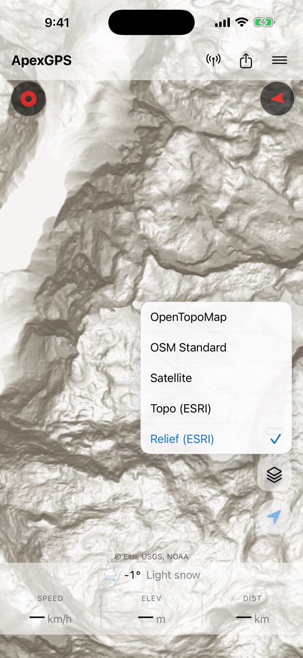
• ESRI Hillshade (shaded relief)
• Thunderforest Outdoors — contour lines + hiking difficulty shading (free API key required, added in Settings)
• Switch styles with the Layers button; your choice is remembered
OFFLINE
• Tiles cache automatically as you browse, ready for airplane mode
• Download a full region: pan the map to frame the area, pick a zoom range, hit Download
• Cache size adjustable in Settings: 250 MB / 500 MB / 1 GB / 2 GB
• Saved regions are stored separately and survive cache cleanups
TRACK RECORDING
• Keeps recording with the screen locked or while you use other apps
• Live stats card right on the map: running duration, distance, elevation with its source (barometer or GPS), and total ascent — with confirmations so you never end a hike by accident
• True mean-sea-level elevation (with a bundled global geoid correction)
• GPS Diagnostics (Settings → Advanced): see exactly which quality gates each GPS fix passes and why a noisy altitude reading was filtered out — with a plain-language explainer for every gate
GPX IMPORT & EXPORT
• Open .gpx files from the Files app or share them in from WhatsApp, Mail, or any file-sharing app
• Multi-file select for bulk import
TRACK PLANNING
• Sketch a route by tapping the map — drop numbered vertices
• Long-press a vertex to drag, long-press a midpoint to insert a new one
• Fetch the route's elevation profile from a worldwide DEM with one tap
WAYPOINTS
• Add by long-pressing the map, entering coordinates, or via GPX import
• 32 OSM-aligned symbols, 16 colour choices
• Long-press and drag on the map to relocate
• Auto-fetch elevation from a worldwide DEM
• Duplicates from re-imported GPX are automatically deduplicated
WEATHER
• Per-waypoint hourly forecast for the next 7 days (Open-Meteo, no API key)
• Current conditions, pressure + humidity charts, sunrise / sunset / UV index
• Fully localized: temperature units, condition labels, time-of-day follow your phone's language
NAVIGATION & SHARING
• Tap any waypoint to start navigation: dotted line, live distance + bearing, auto-stop on arrival
• Full-screen compass mode for hands-free navigation
• Send your live location as a one-tap link — opens in ApexGPS for recipients who have it, web map preview for everyone else
DISTANCE MEASUREMENT
• Tap to drop vertices; drag any vertex to refine; drag a midpoint handle to insert a new vertex
• Total distance shown live in the stats bar
MAP CONTROLS
• Two-finger twist to rotate the map freely
• Follow-me mode with screen-always-on during GPS tracking, plus a live stats bar: speed, elevation, distance
SAMPLE HIKE
• Load a real recording of the Watzmann Traverse (22.6 km, +2250 m) from Settings → Data and explore the app before your own first hike
BACKUP & RESTORE
• Export tracks, waypoints, saved map regions, and settings to a ZIP file
• Restore on another phone with Merge (deduplicates) or Replace modes
PRIVACY
• All data stays on your device; location is never uploaded anywhere
• Map tiles are fetched from public providers (OpenStreetMap, ESRI, Thunderforest) over anonymous HTTPS requests
• No analytics, no tracking, no ad SDKs
REQUIREMENTS
• iPhone with iOS 17 or later
• Location permission (optional — only needed for follow-me / recording)
• No account, no sign-up
Made in the UAE. Feedback welcome at sandwalker.one@proton.me.
Accessibility
ipadiphonemacrealityDevicetvoswatch
Version history 5 versions
Build 887984491v1.42026-07-09 01:07:55
More accurate elevation and a rock-steady position marker.
• Elevation is now anchored to a proper mean-sea-level reference and a calibrated barometer, so altitude reads correctly — including fully offline.
• The live position marker stays locked to your recorded track and snaps back into place the moment you unlock your phone, instead of drifting or lagging behind.
• Track Detail: long track names now scroll into view so you can read the whole name, and renaming opens with the cursor at the end.
• Easier to tap the position marker to share your current location.
Build 887655093v1.12026-07-02 08:04:59
What's new in 1.1:
• Terrain elevation for tracks — a new Terrain (DEM) action looks up elevation from a global terrain model and previews the profile, so you can fill in (or refresh) elevation on any track, then save it as a new copy or overwrite the original. Ideal for imported tracks with missing or flat elevation.
• Switchable weather forecast range — the near-term forecast now toggles between 24h, 8h, and 2h, and the pressure and humidity graphs follow your choice.
• More accurate live weather — the current-location forecast now uses your real altitude (a big difference on peaks), appears sooner, and refreshes more tidily while keeping off the network when you are offline.
• Faster map recovery — the map reloads tiles as soon as you are back online after losing signal, instead of waiting for a pan.
• Polish — clearer green highlight in the Crop and Optimize previews, plus an updated in-app User Guide.
• Reliability — smoother Optimize on very large tracks and smoother saving of very long recordings (the heavy work now runs off the main thread, so the app stays responsive).
Build 887205033v1.0.32026-06-23 20:08:55
What's new in 1.0.3:
• Smoother live location — the position marker now sits exactly on your recorded track instead of drifting a little beside it.
• More reliable opening of GPX files shared from other apps (Mail, Files, messaging): ApexGPS now recognises them even when they arrive tagged as plain text.
Build 887099118v1.0.22026-06-19 06:14:08
What's new in 1.0.2:
• Waypoint clustering is now adjustable (Settings → Appearance): Off, Low, Medium, or Default.
• Compass improvements: it switches to your GPS course when you're driving, the needle moves more smoothly, the ETA turns red when you're moving away from the target, and a hint appears when the compass needs calibrating.
• Track list: long-press a track to multi-select, then change color, show, hide, share, or delete several tracks at once.
• Tap a track to open its overlay, then tap the pencil for full track details. Other tracks dim so the selected one stands out.
• Crop now shows a map preview of the track alongside the elevation profile.
• Optimize keeps a smarter number of points and now works on more tracks.
• More accurate elevation gain and loss on imported tracks.
Build 885090691v1.02026-06-10 22:40:42
No pricing data captured yet — comparisons appear once the app has paid storefronts or in-app purchases.
Availability 172 of 172 storefronts
| Region | Language | Price | Ratings | Avg | Version |
|---|---|---|---|---|---|
| AE | en-GB | Free | 1 | 5.0 | 1.4 |
| US | en-US | Free | 1 | 5.0 | 1.4 |
| AF | en-GB | Free | 0 | — | 1.4 |
| AG | en-GB | Free | 0 | — | 1.4 |
| AI | en-GB | Free | 0 | — | 1.4 |
| AL | en-GB | Free | 0 | — | 1.4 |
| AM | en-GB | Free | 0 | — | 1.4 |
| AO | en-GB | Free | 0 | — | 1.4 |
| AR | es-MX | Free | 0 | — | 1.4 |
| AT | de-DE | Free | 0 | — | 1.4 |
| AU | en-AU | Free | 0 | — | 1.4 |
| AZ | en-GB | Free | 0 | — | 1.4 |
| BA | en-GB | Free | 0 | — | 1.4 |
| BB | en-GB | Free | 0 | — | 1.4 |
| BE | en-GB | Free | 0 | — | 1.4 |
| BF | en-GB | Free | 0 | — | 1.4 |
| BG | en-GB | Free | 0 | — | 1.4 |
| BH | en-GB | Free | 0 | — | 1.4 |
| BJ | en-GB | Free | 0 | — | 1.4 |
| BM | en-GB | Free | 0 | — | 1.4 |
| BN | en-GB | Free | 0 | — | 1.4 |
| BO | es-MX | Free | 0 | — | 1.4 |
| BR | pt-BR | Free | 0 | — | 1.4 |
| BS | en-GB | Free | 0 | — | 1.4 |
| BT | en-GB | Free | 0 | — | 1.4 |
| BW | en-GB | Free | 0 | — | 1.4 |
| BY | en-GB | Free | 0 | — | 1.4 |
| BZ | en-GB | Free | 0 | — | 1.4 |
| CA | en-CA | Free | 0 | — | 1.4 |
| CD | en-GB | Free | 0 | — | 1.4 |
| CG | en-GB | Free | 0 | — | 1.4 |
| CH | de-CH | Free | 0 | — | 1.4 |
| CI | fr-FR | Free | 0 | — | 1.4 |
| CL | es-MX | Free | 0 | — | 1.4 |
| CM | fr-FR | Free | 0 | — | 1.4 |
| CN | zh-Hans-CN | Free | 0 | — | 1.4 |
| CO | es-MX | Free | 0 | — | 1.4 |
| CR | es-MX | Free | 0 | — | 1.4 |
| CV | en-GB | Free | 0 | — | 1.4 |
| CY | en-GB | Free | 0 | — | 1.4 |
| CZ | en-GB | Free | 0 | — | 1.4 |
| DE | de-DE | Free | 0 | — | 1.4 |
| DK | en-GB | Free | 0 | — | 1.4 |
| DM | en-GB | Free | 0 | — | 1.4 |
| DO | es-MX | Free | 0 | — | 1.4 |
| DZ | en-GB | Free | 0 | — | 1.4 |
| EC | es-MX | Free | 0 | — | 1.4 |
| EE | en-GB | Free | 0 | — | 1.4 |
| EG | en-GB | Free | 0 | — | 1.4 |
| ES | es-ES | Free | 0 | — | 1.4 |
| FI | en-GB | Free | 0 | — | 1.4 |
| FJ | en-GB | Free | 0 | — | 1.4 |
| FM | en-GB | Free | 0 | — | 1.4 |
| FR | fr-FR | Free | 0 | — | 1.4 |
| GA | fr-FR | Free | 0 | — | 1.4 |
| GB | en-GB | Free | 0 | — | 1.4 |
| GD | en-GB | Free | 0 | — | 1.4 |
| GE | en-GB | Free | 0 | — | 1.4 |
| GH | en-GB | Free | 0 | — | 1.4 |
| GR | en-GB | Free | 0 | — | 1.4 |
| GT | es-MX | Free | 0 | — | 1.4 |
| GW | en-GB | Free | 0 | — | 1.4 |
| GY | en-GB | Free | 0 | — | 1.4 |
| HK | zh-Hant-HK | Free | 0 | — | 1.4 |
| HN | es-MX | Free | 0 | — | 1.4 |
| HR | en-GB | Free | 0 | — | 1.4 |
| HU | en-GB | Free | 0 | — | 1.4 |
| ID | en-GB | Free | 0 | — | 1.4 |
| IE | en-GB | Free | 0 | — | 1.4 |
| IL | en-GB | Free | 0 | — | 1.4 |
| IN | en-GB | Free | 0 | — | 1.4 |
| IQ | en-GB | Free | 0 | — | 1.4 |
| IS | en-GB | Free | 0 | — | 1.4 |
| IT | it | Free | 0 | — | 1.4 |
| JM | en-GB | Free | 0 | — | 1.4 |
| JO | en-GB | Free | 0 | — | 1.4 |
| JP | ja | Free | 0 | — | 1.4 |
| KE | en-GB | Free | 0 | — | 1.4 |
| KG | en-GB | Free | 0 | — | 1.4 |
| KH | en-GB | Free | 0 | — | 1.4 |
| KN | en-GB | Free | 0 | — | 1.4 |
| KR | ko | Free | 0 | — | 1.4 |
| KW | en-GB | Free | 0 | — | 1.4 |
| KY | en-GB | Free | 0 | — | 1.4 |
| KZ | en-GB | Free | 0 | — | 1.4 |
| LA | en-GB | Free | 0 | — | 1.4 |
| LB | en-GB | Free | 0 | — | 1.4 |
| LC | en-GB | Free | 0 | — | 1.4 |
| LK | en-GB | Free | 0 | — | 1.4 |
| LT | en-GB | Free | 0 | — | 1.4 |
| LU | en-GB | Free | 0 | — | 1.4 |
| LV | en-GB | Free | 0 | — | 1.4 |
| LY | en-GB | Free | 0 | — | 1.4 |
| MA | en-GB | Free | 0 | — | 1.4 |
| MD | en-GB | Free | 0 | — | 1.4 |
| ME | en-GB | Free | 0 | — | 1.4 |
| MG | en-GB | Free | 0 | — | 1.4 |
| MK | en-GB | Free | 0 | — | 1.4 |
| ML | en-GB | Free | 0 | — | 1.4 |
| MM | en-GB | Free | 0 | — | 1.4 |
| MN | en-GB | Free | 0 | — | 1.4 |
| MO | zh-Hant-HK | Free | 0 | — | 1.4 |
| MR | en-GB | Free | 0 | — | 1.4 |
| MS | en-GB | Free | 0 | — | 1.4 |
| MT | en-GB | Free | 0 | — | 1.4 |
| MU | en-GB | Free | 0 | — | 1.4 |
| MV | en-GB | Free | 0 | — | 1.4 |
| MW | en-GB | Free | 0 | — | 1.4 |
| MX | es-MX | Free | 0 | — | 1.4 |
| MY | en-GB | Free | 0 | — | 1.4 |
| MZ | en-GB | Free | 0 | — | 1.4 |
| NA | en-GB | Free | 0 | — | 1.4 |
| NE | en-GB | Free | 0 | — | 1.4 |
| NG | en-GB | Free | 0 | — | 1.4 |
| NI | es-MX | Free | 0 | — | 1.4 |
| NL | nl | Free | 0 | — | 1.4 |
| NO | en-GB | Free | 0 | — | 1.4 |
| NP | en-GB | Free | 0 | — | 1.4 |
| NR | en-GB | Free | 0 | — | 1.4 |
| NZ | en-AU | Free | 0 | — | 1.4 |
| OM | en-GB | Free | 0 | — | 1.4 |
| PA | es-MX | Free | 0 | — | 1.4 |
| PE | es-MX | Free | 0 | — | 1.4 |
| PG | en-GB | Free | 0 | — | 1.4 |
| PH | en-GB | Free | 0 | — | 1.4 |
| PK | en-GB | Free | 0 | — | 1.4 |
| PL | en-GB | Free | 0 | — | 1.4 |
| PT | pt-PT | Free | 0 | — | 1.4 |
| PW | en-GB | Free | 0 | — | 1.4 |
| PY | es-MX | Free | 0 | — | 1.4 |
| QA | en-GB | Free | 0 | — | 1.4 |
| RO | en-GB | Free | 0 | — | 1.4 |
| RS | en-GB | Free | 0 | — | 1.4 |
| RU | ru | Free | 0 | — | 1.4 |
| RW | en-GB | Free | 0 | — | 1.4 |
| SA | en-GB | Free | 0 | — | 1.4 |
| SB | en-GB | Free | 0 | — | 1.4 |
| SC | en-GB | Free | 0 | — | 1.4 |
| SE | sv | Free | 0 | — | 1.4 |
| SG | en-GB | Free | 0 | — | 1.4 |
| SI | en-GB | Free | 0 | — | 1.4 |
| SK | en-GB | Free | 0 | — | 1.4 |
| SL | en-GB | Free | 0 | — | 1.4 |
| SN | en-GB | Free | 0 | — | 1.4 |
| SR | en-GB | Free | 0 | — | 1.4 |
| ST | en-GB | Free | 0 | — | 1.4 |
| SV | es-MX | Free | 0 | — | 1.4 |
| TC | en-GB | Free | 0 | — | 1.4 |
| TD | en-GB | Free | 0 | — | 1.4 |
| TH | en-GB | Free | 0 | — | 1.4 |
| TJ | en-GB | Free | 0 | — | 1.4 |
| TM | en-GB | Free | 0 | — | 1.4 |
| TN | en-GB | Free | 0 | — | 1.4 |
| TO | en-GB | Free | 0 | — | 1.4 |
| TR | en-GB | Free | 0 | — | 1.4 |
| TT | en-GB | Free | 0 | — | 1.4 |
| TW | zh-Hant-TW | Free | 0 | — | 1.4 |
| TZ | en-GB | Free | 0 | — | 1.4 |
| UA | en-GB | Free | 0 | — | 1.4 |
| UG | en-GB | Free | 0 | — | 1.4 |
| UY | en-GB | Free | 0 | — | 1.4 |
| UZ | en-GB | Free | 0 | — | 1.4 |
| VC | en-GB | Free | 0 | — | 1.4 |
| VE | es-MX | Free | 0 | — | 1.4 |
| VG | en-GB | Free | 0 | — | 1.4 |
| VN | en-GB | Free | 0 | — | 1.4 |
| VU | en-GB | Free | 0 | — | 1.4 |
| XK | en-GB | Free | 0 | — | 1.4 |
| YE | en-GB | Free | 0 | — | 1.4 |
| ZA | en-GB | Free | 0 | — | 1.4 |
| ZM | en-GB | Free | 0 | — | 1.4 |
| ZW | en-GB | Free | 0 | — | 1.4 |
Change log 9 changes · PH
✎
releaseNotes updated
More accurate elevation and a rock-steady position marker.
• Elevation is now anchored to a proper mean-sea-level reference and a calibrated barometer, so alti
✎
description updated
ApexGPS is a free iPhone hiking app for people who want the essentials of a good GPS navigator without ads, subscriptions, or the need to sign up. Offline maps,
✎
subtitle updated
Offline maps · GPX · weather
✎
name updated
ApexGPS Hiking
◆
Version 1.4 released
More accurate elevation and a rock-steady position marker.
• Elevation is now anchored to a proper mean-sea-level reference and a calibrated barometer, so altitude reads correctly — including fully offline.
• The live position marker stays
◆
Version 1.1 released
What's new in 1.1:
• Terrain elevation for tracks — a new Terrain (DEM) action looks up elevation from a global terrain model and previews the profile, so you can fill in (or refresh) elevation on any track, then save it as a new copy or o
◆
Version 1.0.3 released
What's new in 1.0.3:
• Smoother live location — the position marker now sits exactly on your recorded track instead of drifting a little beside it.
• More reliable opening of GPX files shared from other apps (Mail, Files, messaging): ApexG
◆
Version 1.0.2 released
What's new in 1.0.2:
• Waypoint clustering is now adjustable (Settings → Appearance): Off, Low, Medium, or Default.
• Compass improvements: it switches to your GPS course when you're driving, the needle moves more smoothly, the ETA turns r
◆
Version 1.0 released