Home › Weather

Information
Preview 1 platform
iPhone 10 images


What’s New Version 1.0.6
The biggest DisasterNet update yet.
LIVE ACTIVE FAULT LINES (NEW)
See the world's active tectonic faults right on the map — the cracks in the Earth's crust where earthquakes are born. Instantly check whether you or your loved ones live near an active fault. Toggle the layer on or off anytime, and pick your detail level: Major, Moderate, or All.
JAPAN EARTHQUAKES VIA JMA (NEW)
We added the Japan Meteorological Agency (JMA), Japan's official source, for fast and precise coverage of every earthquake in and around one of the most seismically active regions on Earth. DisasterNet now draws from four official earthquake agencies: USGS, EMSC, AFAD, and JMA.
Also in this update:
- Smoother, faster map
- Improved earthquake details and source labels
- Various fixes and refinements
Thank you for using DisasterNet. Stay safe.
Description
DisasterNet — Real-time Earthquake, Wildfire, and Fault Line Tracker
See our planet in motion. DisasterNet brings together official data from the world's leading geological and space agencies into one fast, beautiful, privacy-first app for iPhone and iPad.
Whether you live in a seismic zone, follow news from home while abroad, or simply care about what is happening on Earth, DisasterNet gives you a clear, trustworthy, real-time view — with a feature no other app offers.
WHAT MAKES DISASTERNET DIFFERENT: LIVE ACTIVE FAULT LINES
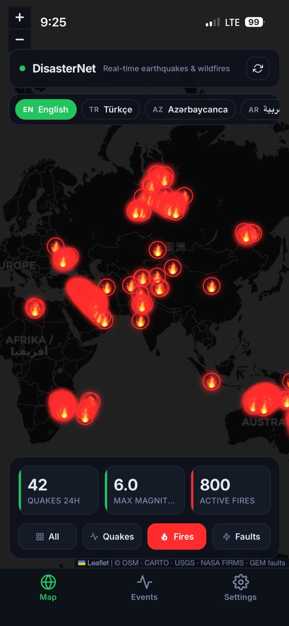
This is the feature you will not find anywhere else. DisasterNet draws the world's active tectonic fault lines directly on the map — the very cracks in the Earth's crust where earthquakes are born.
- Instantly see if you, your home, or your loved ones live near an active fault
- Watch earthquakes appear right along the fault lines that caused them
- Turn the fault layer on or off anytime with a single tap
- Choose exactly how much detail you want:
Major — only the largest, most significant faults
Moderate — major plus mid-sized faults
All — every mapped active fault on Earth
Fault data comes from the GEM Global Active Faults Database, the international scientific standard.
EARTHQUAKES FROM FOUR OFFICIAL SOURCES
DisasterNet combines live earthquake data from four official agencies:
- USGS — United States Geological Survey (global)
- EMSC — European-Mediterranean Seismological Centre
- AFAD — Turkiye Disaster and Emergency Management Authority
- JMA — Japan Meteorological Agency
Japan is one of the most seismically active places on Earth, so we added JMA, the official Japanese authority, for fast and precise coverage of every quake in and around Japan.
When the same earthquake is reported by more than one agency, DisasterNet intelligently merges them into a single, most-accurate event — while still showing which agency reported it, for full transparency.
LIVE WILDFIRES FROM NASA SATELLITES
Active fire detection from NASA FIRMS:
- Updated multiple times a day from MODIS and VIIRS satellites
- Worldwide coverage, no regional limits
- See exactly where fires are burning right now
A BEAUTIFUL DARK INTERACTIVE MAP
- Smooth pan and zoom on a global dark map
- Earthquake markers color-coded by magnitude
- Active fault lines drawn over the terrain
- Tap any earthquake, fire, or fault for instant details
- Powered by OpenStreetMap, no usage limits
BUILT FOR EVERYONE, EVERYWHERE
- 20 languages, with full right-to-left support for Arabic and Persian
- Magnitude filter from M0 to M5+
- Time range: last hour, last day, or last week
- Sortable list view with full event details
- Source shown for every earthquake
- Native dark mode, easy on the eyes
- Optimized for iPhone and iPad, portrait and landscape
PRIVACY FIRST — ALWAYS
- No accounts, no signup
- No ads, no tracking, no analytics
- No location permission required
- All preferences stay on your device
- Every data source is public and clearly credited in the app
IMPORTANT
DisasterNet is an informational and educational tool. It does not replace official emergency alerts from your government or national disaster authority. Always follow local authorities during a disaster. Magnitudes and fire detections come from third-party agencies and may be revised over time.
DATA SOURCES
USGS · EMSC · AFAD · JMA · NASA FIRMS · GEM Global Active Faults · OpenStreetMap · CARTO
All sources are public. Attribution is provided inside the app.
ONE-TIME PURCHASE
DisasterNet is a single one-time purchase. No subscriptions, no in-app purchases, no hidden costs. Buy once, use forever on every Apple device tied to your Apple Account.
Download DisasterNet today and see the Earth move in real time.
Thank you for choosing DisasterNet. Stay safe.
Accessibility
ipadiphonemacrealityDevicetvoswatch
Version history 6 versions
Build 887692917v1.0.62026-07-03 03:53:54
The biggest DisasterNet update yet.
LIVE ACTIVE FAULT LINES (NEW)
See the world's active tectonic faults right on the map — the cracks in the Earth's crust where earthquakes are born. Instantly check whether you or your loved ones live near an active fault. Toggle the layer on or off anytime, and pick your detail level: Major, Moderate, or All.
JAPAN EARTHQUAKES VIA JMA (NEW)
We added the Japan Meteorological Agency (JMA), Japan's official source, for fast and precise coverage of every earthquake in and around one of the most seismically active regions on Earth. DisasterNet now draws from four official earthquake agencies: USGS, EMSC, AFAD, and JMA.
Also in this update:
- Smoother, faster map
- Improved earthquake details and source labels
- Various fixes and refinements
Thank you for using DisasterNet. Stay safe.
Build 886622833v1.0.52026-06-09 07:51:49
This update significantly improves data connection stability. Earthquake and wildfire data now loads faster and more reliably. Performance improvements and bug fixes.
Build 886169396v1.0.42026-05-29 00:57:02
• Fixed data loading issue: earthquake and wildfire data now displays reliably worldwide.
• Improved network stability and performance.
• Backend infrastructure upgraded for 24/7 availability.
Build 886047378v1.0.12026-05-26 12:05:06
• Enhanced map popups with detailed location, depth, and source info
• Wildfire popups now show city and country names
• Improved privacy policy with full third-party data source disclosure
• Performance and stability improvements
Build 886155268v1.0.22026-05-26 21:13:59
• Fixed an issue where earthquake and wildfire data was not loading.
• Extended magnitude filter range up to 9.0.
Build 885072659v1.02026-05-12 20:24:52
Price history by region
Currency
Show
Columns
Search
Availability 24 of 24 storefronts
| Region | Language | Price | Ratings | Avg | Version |
|---|---|---|---|---|---|
 AG AG | en-GB | USD 1.99 | 0 | — | 1.0.6 |
 AM AM | en-GB | USD 1.99 | 0 | — | 1.0.6 |
 BS BS | en-GB | USD 1.99 | 0 | — | 1.0.6 |
 CN CN | zh-Hans-CN | CNY 15 | 0 | — | 1.0.6 |
 DM DM | en-GB | USD 1.99 | 0 | — | 1.0.6 |
 DO DO | es-MX | USD 1.99 | 0 | — | 1.0.6 |
 DZ DZ | en-GB | USD 1.99 | 0 | — | 1.0.6 |
 GM GM | en-GB | USD 1.99 | 0 | — | 1.0.6 |
 GW GW | en-GB | USD 1.99 | 0 | — | 1.0.6 |
 HN HN | es-MX | USD 1.99 | 0 | — | 1.0.6 |
 IL IL | en-GB | ILS 7.9 | 0 | — | 1.0.6 |
 JM JM | en-GB | USD 1.99 | 0 | — | 1.0.6 |
 LR LR | en-GB | USD 1.99 | 0 | — | 1.0.6 |
 LY LY | en-GB | USD 1.99 | 0 | — | 1.0.6 |
 MA MA | en-GB | USD 1.99 | 0 | — | 1.0.6 |
 NG NG | en-GB | NGN 3200 | 0 | — | 1.0.6 |
 NI NI | es-MX | USD 1.99 | 0 | — | 1.0.6 |
 RW RW | en-GB | USD 1.99 | 0 | — | 1.0.6 |
 SA SA | en-GB | SAR 9.99 | 0 | — | 1.0.6 |
 SR SR | en-GB | USD 1.99 | 0 | — | 1.0.6 |
 TN TN | en-GB | USD 1.99 | 0 | — | 1.0.6 |
 TT TT | en-GB | USD 1.99 | 0 | — | 1.0.6 |
 TW TW | zh-Hant-TW | TWD 60 | 0 | — | 1.0.6 |
 US US | en-US | USD 1.99 | 0 | — | 1.0.6 |
Change log 10 changes · DO
✎
releaseNotes updated
The biggest DisasterNet update yet.
LIVE ACTIVE FAULT LINES (NEW)
See the world's active tectonic faults right on the map — the cracks in the Earth's crust whe
✎
description updated
DisasterNet — Real-time Earthquake, Wildfire, and Fault Line Tracker
See our planet in motion. DisasterNet brings together official data from the world's lead
✎
subtitle updated
Live earthquakes & wildfires
✎
name updated
DisasterNet — Quakes & Fires
◆
Version 1.0.6 released
The biggest DisasterNet update yet.
LIVE ACTIVE FAULT LINES (NEW)
See the world's active tectonic faults right on the map — the cracks in the Earth's crust where earthquakes are born. Instantly check whether you or your loved ones live nea
◆
Version 1.0.5 released
This update significantly improves data connection stability. Earthquake and wildfire data now loads faster and more reliably. Performance improvements and bug fixes.
◆
Version 1.0.4 released
• Fixed data loading issue: earthquake and wildfire data now displays reliably worldwide.
• Improved network stability and performance.
• Backend infrastructure upgraded for 24/7 availability.
◆
Version 1.0.2 released
• Fixed an issue where earthquake and wildfire data was not loading.
• Extended magnitude filter range up to 9.0.
◆
Version 1.0.1 released
• Enhanced map popups with detailed location, depth, and source info
• Wildfire popups now show city and country names
• Improved privacy policy with full third-party data source disclosure
• Performance and stability improvements
◆
Version 1.0 released