Home › Navigation

 ZW
ZW
 DEde-DE
 PLen-GB
 USen-US
 FRfr-FR
 ITit
ITit GBen-GB
 CHde-CH
 CAen-CA
 ATde-DE
 CZen-GB
 ESes-ES
 ECes-MX
 MXes-MX
 NLnl
NLnl AUen-AU
 SEsv
SEsv BEen-GB
 CLes-MX
 HUen-GB
 NOen-GB
 SIen-GB
 ARes-MX
 BGen-GB
 CGen-GB
 LTen-GB
 ROen-GB
 SKen-GB
 UAen-GBZWen-GB
 AGen-GB
 AIen-GB
 ALen-GB
 AOen-GB
 BAen-GB
 BBen-GB
 BFen-GB
 BJen-GB
 BOes-MX
 BRpt-BR
 BSen-GB
 BWen-GB
 BYen-GB
 BZen-GB
 CDen-GB
 CIfr-FR
 CMfr-FR
 COes-MX
 CRes-MX
 CVen-GB
 CYen-GB
 DKen-GB
 DMen-GB
 DOes-MX
 DZen-GB
 EEen-GB
 FIen-GB
 GAfr-FR
 GDen-GB
 GHen-GB
 GMen-GB
 GRen-GB
 GTes-MX
 GWen-GB
 GYen-GB
 HNes-MX
 HRen-GB
 IEen-GB
 ISen-GB
 JMen-GB
 KEen-GB
 KNen-GB
 KYen-GB
 LCen-GB
 LRen-GB
 LUen-GB
 LVen-GB
 LYen-GB
 MAen-GB
 MDen-GB
 MEen-GB
 MGen-GB
 MKen-GB
 MLen-GB
 MSen-GB
 MTen-GB
 MUen-GB
 MWen-GB
 MZen-GB
 NAen-GB
 NEen-GB
 NGen-GB
 NIes-MX
 NZen-AU
 PAes-MX
 PEes-MX
 PTpt-PT
 PYes-MX
 RSen-GB
 RWen-GB
 SCen-GB
 SLen-GB
 SNen-GB
 SRen-GB
 STen-GB
 SVes-MX
 SZen-GB
 TCen-GB
 TDen-GB
 TNen-GB
 TTen-GB
 TZen-GB
 UGen-GB
 UYen-GB
 VCen-GB
 VEes-MX
 VGen-GB
 XKen-GB
 ZMen-GB
 RUNot Available
118 of 119 storefronts
Content in en-US
Content in en-US
Information
Preview 2 platforms
iPhone 10 images




Apple Watch 10 images




What’s New Version 6.8
• Sync to Strava — connect your Strava account and recorded workouts upload automatically, with all health metrics and full GPS track. You can also send older activities anytime from the route menu.
• More Activity Types — record activities like e-bike and eMTB, gravel, kayaking, hunting, and skateboarding, plus many more, each with its own color-coded icon and the right mapping when you sync to Strava or Health.
• Search by Coordinates — paste coordinates to jump straight to a spot: decimal degrees, DMS, Plus Codes, UTM/MGRS, even British and Swiss grids. It works offline, and the format is detected for you.
Description
Never lose your way. From planning to navigating to recording — all in WristTopo. Plan routes on your iPhone, sync them instantly, and navigate offline on your Apple Watch. No fiddling with your phone on the trail, mid-run, or during a ride — just reliable navigation and maps, always ready when you need them. WristTopo works on your watch without your phone or network.
FOR EVERY ADVENTURE
Hiking, cycling, mountain biking, skiing, paddling, and dozens more — all better when you can navigate phone-free. WristTopo adapts to how you move, with routing built for the trail.
TURN-BY-TURN NAVIGATION
Stay on track with voice guidance and visual turn notifications right on your wrist. See upcoming turns, distances, and hear spoken directions — no phone needed. Navigation works with routes planned in WristTopo and imported GPX routes, giving you confidence to explore new trails without constantly checking your phone.
RECORD YOUR ADVENTURES
Start a workout from your wrist — from hikes and trail runs to rides, skiing, and paddling. Track distance, pace, elevation, and heart rate in real time, saved to Apple Health — on fully customizable workout screens. Prefer Apple's Workout app? It still runs alongside WristTopo — recording and navigation stay independent.
ROUTE PLANNER
Create your perfect route before you head out — whether you're planning a hike, run, trail run, or bike ride. Simply tap to set waypoints and watch your route come to life with instant distance and elevation feedback. Choose from running, hiking, biking, mountain biking, or straight-line routing modes to match your adventure. It's incredibly intuitive — no complex menus or confusing settings, just tap and plan.
QUICK ROUTE ON YOUR WATCH
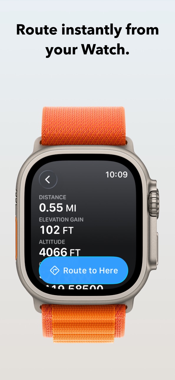
Need a simple route on the go? Plan directly on your watch from wherever you are. Quick Route lets you create instant point-to-point routes right from your wrist — perfect for navigating to a viewpoint or exploring from your current location. No phone needed.
BACKTRACK TO YOUR START
Lost your way? While recording on Apple Watch, one tap on Backtrack creates a route back along your trail — with turn-by-turn guidance all the way home.
OFFLINE MAPS, FOR REAL
Download detailed summer, winter, or satellite maps straight to your watch. Once saved, they're always available — no connection needed. Choose an entire area for general use, or download map sections around a route with a single tap.
CUSTOM GPX ROUTES, INSTANT SYNC
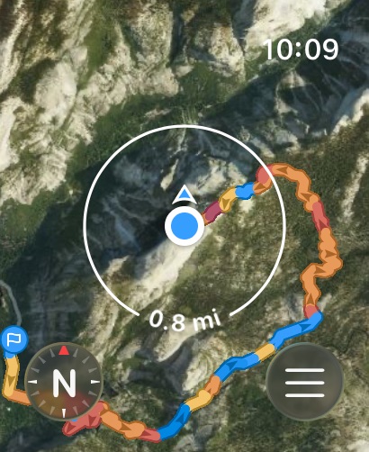
Import GPX files into the iPhone app and they sync instantly to your watch. Generate turn-by-turn directions for any imported route and navigate with voice guidance on Apple Watch. Toggle routes with a tap. Display multiple routes at once. Routes include gradient colors (orange uphill, blue downhill) and direction arrows, so you can see steepness and direction at a glance.
BUILT FOR THE OUTDOORS
Navigation on Apple Watch can be this smooth. Ultra-fast performance, sharp topography, shaded relief, satellite imagery, and winter ski trails — all optimized for Apple Watch and real-world conditions.
ICLOUD BACKUP
Routes and offline map regions sync between your devices. Everything survives reinstalls and device upgrades automatically.
PRIVATE BY DESIGN
No accounts. No advertising. No tracking. Your routes and recordings stay on your device, syncing only to your own iCloud.
FREE TO START
WristTopo is free to try with everything you need for shorter adventures:
• Up to 3 saved routes
• 3 small offline map regions
• Plan with up to 5 route points
• Follow routes on your Apple Watch
UNLOCK PRO
Upgrade for more flexibility:
• Unlimited routes and larger offline regions
• Voice-guided turn-by-turn navigation
• Workout recording with Apple Health sync
• Quick Route planning on your Apple Watch
• GPX export to share your own routes
• Support independent app development
Terms of Use: https://www.apple.com/legal/internet-services/itunes/dev/stdeula/
Privacy Policy: https://wristtopo.app/privacy
In-App Purchases ZW pricing
PRO Subscription
Yearly—
One-Time Purchases
PRO Lifetime—
Capabilities
In-App Purchases
Accessibility
ipadiphonemacrealityDevicetvoswatch
Version history 25 versions
Build 887343134v6.82026-06-23 22:03:34
• Sync to Strava — connect your Strava account and recorded workouts upload automatically, with all health metrics and full GPS track. You can also send older activities anytime from the route menu.
• More Activity Types — record activities like e-bike and eMTB, gravel, kayaking, hunting, and skateboarding, plus many more, each with its own color-coded icon and the right mapping when you sync to Strava or Health.
• Search by Coordinates — paste coordinates to jump straight to a spot: decimal degrees, DMS, Plus Codes, UTM/MGRS, even British and Swiss grids. It works offline, and the format is detected for you.
Build 886961723v6.72026-06-18 02:33:00
• Smarter Map Search — search on iPhone is faster and more accurate, suggesting places as you type and finding far more of them, including local businesses and points of interest.
• Walk & Run Routes — a new route type for everyday walks and runs that favors the shortest, most direct paths, especially in town. Prefer Hike for marked trails and more scenic routes, including trail running.
• Compass Mode on iPhone — already on Apple Watch, the iPhone map can now rotate to match the direction you're facing too. Tap the location button to center on yourself, then tap again to switch it on.
• Elevation Accuracy — improvements to the elevation gain recording algorithm for more accurate results.
Build 886854082v6.6.12026-06-12 16:15:12
Workout metrics are now fully yours to customize.
• Build Your Own Workout Screens — choose which stats you see while recording, from pace and heart rate to elevation, and arrange them just the way you like in a clean new iPhone editor.
• Syncs Live to Your Watch — your layout appears on Apple Watch the moment you change it, even mid-workout. No need to stop or re-sync.
• More Metrics to Track — splits, speed, and running dynamics join pace, heart rate, and elevation, all sorted into clear categories.
• Watch Connection — small improvements to the reliability of iPhone–Watch communication.
Build 886700848v6.62026-06-09 16:45:12
Workout metrics are now fully yours to customize.
• Build Your Own Workout Screens — choose which stats you see while recording, from pace and heart rate to elevation, and arrange them just the way you like in a clean new iPhone editor.
• Syncs Live to Your Watch — your layout appears on Apple Watch the moment you change it, even mid-workout. No need to stop or re-sync.
• More Metrics to Track — splits, speed, and running dynamics join pace, heart rate, and elevation, all sorted into clear categories.
Build 886501304v6.52026-06-04 16:28:28
A few handy new settings this time, to make WristTopo fit you a little better.
• Settings on iPhone — adjust your preferences in one place, and everything syncs to Apple Watch automatically.
• Choose Your Units — pick Metric or Imperial for distance and elevation, independent of your device's region.
• Navigation, Your Way — set Turn Cues and Off-Route Alerts separately. Each can be a haptic tap, a spoken cue, or off.
Build 886242334v6.4.12026-05-30 11:47:56
This update is almost all about the map — and it's the biggest one yet. Brand new data and a fully reworked outdoor style.
• Clearer in Cities — built-up areas are much easier to read now. Buildings, roads, and labels were retuned for a calmer, warmer look.
• Paths, Reworked — every trail and track redrawn from scratch. Dashed lines mean unpaved, solid lines mean paved, so you can read each path at a glance.
• MTB Trails — mountain bike trails are now their own layer on the map, colored by difficulty: green, blue, red, and black.
• More Alpine Detail — SAC-graded T4–T6 sections get a colored stripe so demanding terrain stands out, with more trail names and route numbers across the Alps.
• Smooth Upgrade — maps refresh automatically as you use them. No re-downloads needed.
• Bug Fixes — fixed issues with navigation and the elevation profile, plus other small improvements.
Build 886171765v6.42026-05-27 18:55:15
This update is almost all about the map — and it's the biggest one yet. Brand new data and a fully reworked outdoor style.
• Clearer in Cities — built-up areas are much easier to read now. Buildings, roads, and labels were retuned for a calmer, warmer look.
• Paths, Reworked — every trail and track redrawn from scratch. Dashed lines mean unpaved, solid lines mean paved, so you can read each path at a glance.
• MTB Trails — mountain bike trails are now their own layer on the map, colored by difficulty: green, blue, red, and black.
• More Alpine Detail — SAC-graded T4–T6 sections get a colored stripe so demanding terrain stands out, with more trail names and route numbers across the Alps.
• Smooth Upgrade — maps refresh automatically as you use them. No re-downloads needed.
• Bug Fixes — fixed issues with navigation and the elevation profile, plus other small improvements.
Build 885736852v6.3.12026-05-16 17:14:14
You've been asking for an interactive elevation chart. Here it is, on both Watch and iPhone.
• Elevation Profile on Watch — navigate a route on Apple Watch and see a live elevation profile. Slide to any point to see the distance ahead and how much elevation gain is still to go.
• Elevation Profiles on iPhone — the iPhone elevation profile got a real upgrade this version. Grade coloring highlights the steepest sections, and sliding along the chart shows your position on the map.
• Better Routes on Watch — route gradient coloring is more precise, rendering is faster, and several smaller improvements.
• Route Planner — fixed a small issue that could prevent a waypoint from being removed.
Build 885687796v6.32026-05-14 23:43:28
You've been asking for an interactive elevation chart. Here it is, on both Watch and iPhone.
• Elevation Profile on Watch — navigate a route on Apple Watch and see a live elevation profile. Slide to any point to see the distance ahead and how much elevation gain is still to go.
• Elevation Profiles on iPhone — the iPhone elevation profile got a real upgrade this version. Grade coloring highlights the steepest sections, and sliding along the chart shows your position on the map.
• Better Routes on Watch — route gradient coloring is more precise, rendering is faster, and several smaller improvements.
Build 885399921v6.22026-05-08 08:31:45
• Backtrack on Apple Watch — Lost your way? One tap during a recording navigates you back along your trail to the start, with turn-by-turn directions.
• Navigation for every route — every imported or recorded route now navigates instantly on Apple Watch, even off-trail. No setup needed.
• Snap to Trails — optional step for aligning routes to known paths when you want extra precision.
Build 885073408v6.12026-05-02 18:57:41
• Live track on Apple Watch — see your path drawn on the map in real time as you record.
• Smoother turn-by-turn navigation — refined engine with better handling of U-turns and unusual maneuvers.
Build 884804099v6.02026-04-23 22:02:35
• Record workouts on Apple Watch — hikes, runs, cycling, and more. Track distance, pace, elevation, and heart rate in real time, then sync to Apple Health.
• Apple Watch Ultra: start a workout and open the Data Screen with the Action Button.
• Double tap to quickly open or close the Data Screen.
• Star the routes you need for your trip — use the Starred filter on Apple Watch to find them fast.
• Reorganized routes on Apple Watch — tap any route to show it on the map or start navigating.
Build 883063298v5.22026-03-05 21:32:20
• Imported GPX routes now support turn-by-turn navigation. Generate directions for any route and navigate with your Apple Watch.
Build 882443217v5.12026-02-13 19:42:08
• Routes now display start and finish flag markers on both iPhone and Apple Watch, so you can instantly see where your route begins and ends.
• Redesigned turn-by-turn navigation markers on Apple Watch for a cleaner look.
• Navigation engine and audio reliability improvements.
Build 880926594v5.02025-12-28 00:08:20
• Turn-by-turn navigation is here! Get voice and visual cues for upcoming turns right on your Apple Watch. Your outdoor adventures just got a whole lot easier.
• Various fixes and performance improvements.
Build 879535506v4.62025-11-10 17:23:04
• Brazilian Portuguese support.
• Major infrastructure upgrades underway for v5.0's turn-by-turn navigation! Want early access? Contact Support to join the beta testing program.
Build 879274876v4.52025-10-28 21:21:29
• The app now supports Spanish, French, Japanese, Italian, and Korean.
Build 878813449v4.42025-10-11 10:31:04
• Watch App clock now adjusts its color depending on the map type for better readability (black for light maps, and white for satellite).
• Significantly improved performance of the watch app map panning for even better responsiveness.
Build 878718430v4.32025-10-08 01:53:48
• Chinese language support — the app now fully supports Simplified Chinese.
• Fixed a rare crash that could occur when deleting routes, improving overall app reliability.
Build 878635234v4.2.12025-10-04 11:05:35
• Offline maps with elevation data — the Watch app now displays elevation gain and loss in the info bubble, even when you're offline.
• Minor updates to enhance app performance and stability.
Build 878547276v4.22025-10-01 01:33:56
• Offline maps with elevation data — the Watch app now displays elevation gain and loss in the info bubble, even when you're offline.
Build 878410164v4.1.12025-09-26 06:32:54
• Liquid Glass restyling — enjoy the beautiful new design on iPhone and Apple Watch.
• Location info bubble — pan around the map and see crosshair with distance and elevation info.
• Quick Route on Apple Watch — create routes from your current location right on your wrist.
• Smart map overlay theming — controls adapt to light/dark based on map type.
• WatchOS10/iOS17 stability fix — resolved crash issue when adding or importing routes.
• Under the hood improvements — minor updates to enhance app performance and stability.
Build 878240969v4.12025-09-20 04:22:17
• Liquid Glass restyling — enjoy the beautiful new design on iPhone and Apple Watch.
• Location info bubble — pan around the map and see crosshair with distance and elevation info.
• Quick Route on Apple Watch — create routes from your current location right on your wrist.
• Smart map overlay theming — controls adapt to light/dark based on map type.
• WatchOS10/iOS17 stability fix — resolved crash issue when adding or importing routes.
Build 877789261v4.0.12025-09-03 05:58:48
• Route Planner – now built into WristTopo! Create routes on iPhone and sync them to Apple Watch instantly
• Interactive 3D maps – explore terrain and elevation in stunning detail
• Refreshed interface – cleaner, faster, easier to use
• Enhanced GPX import and export – smoother syncing and the ability to share your routes
• Performance improvements and bug fixes – making WristTopo more reliable than ever
Build 877091296v4.02025-08-28 21:20:53
• Route Planner – now built into WristTopo! Create routes on iPhone and sync them to Apple Watch instantly
• Interactive 3D maps – explore terrain and elevation in stunning detail
• Refreshed interface – cleaner, faster, easier to use
• Enhanced GPX import and export – smoother syncing and the ability to share your routes
• Performance improvements and bug fixes – making WristTopo more reliable than ever
Price history by region
Currency
Show
Columns
Search
Availability 118 of 119 storefronts
| Region | Language | Price | Ratings | Avg | Version |
|---|---|---|---|---|---|
| DE | de-DE | Free | 102 | 4.8 | 6.8 |
| PL | en-GB | Free | 66 | 4.8 | 6.8 |
| US | en-US | Free | 53 | 4.8 | 6.8 |
| FR | fr-FR | Free | 24 | 4.9 | 6.8 |
| IT | it | Free | 17 | 4.7 | 6.8 |
| GB | en-GB | Free | 13 | 5.0 | 6.8 |
| CH | de-CH | Free | 11 | 4.9 | 6.8 |
| CA | en-CA | Free | 9 | 4.6 | 6.8 |
| AT | de-DE | Free | 8 | 4.9 | 6.8 |
| CZ | en-GB | Free | 8 | 4.9 | 6.8 |
| ES | es-ES | Free | 8 | 5.0 | 6.8 |
| EC | es-MX | Free | 6 | 5.0 | 6.8 |
| MX | es-MX | Free | 6 | 5.0 | 6.8 |
| NL | nl | Free | 5 | 4.6 | 6.8 |
| AU | en-AU | Free | 4 | 5.0 | 6.8 |
| SE | sv | Free | 3 | 5.0 | 6.8 |
| BE | en-GB | Free | 2 | 5.0 | 6.8 |
| CL | es-MX | Free | 2 | 5.0 | 6.8 |
| HU | en-GB | Free | 2 | 5.0 | 6.8 |
| NO | en-GB | Free | 2 | 5.0 | 6.8 |
| SI | en-GB | Free | 2 | 5.0 | 6.8 |
| AR | es-MX | Free | 1 | 5.0 | 6.8 |
| BG | en-GB | Free | 1 | 5.0 | 6.8 |
| CG | en-GB | Free | 1 | 5.0 | 6.8 |
| LT | en-GB | Free | 1 | 1.0 | 6.8 |
| RO | en-GB | Free | 1 | 5.0 | 6.8 |
| SK | en-GB | Free | 1 | 5.0 | 6.8 |
| UA | en-GB | Free | 1 | 5.0 | 6.8 |
| ZW | en-GB | Free | 1 | 5.0 | 6.8 |
| AG | en-GB | Free | 0 | — | 6.8 |
| AI | en-GB | Free | 0 | — | 6.8 |
| AL | en-GB | Free | 0 | — | 6.8 |
| AO | en-GB | Free | 0 | — | 6.8 |
| BA | en-GB | Free | 0 | — | 6.8 |
| BB | en-GB | Free | 0 | — | 6.8 |
| BF | en-GB | Free | 0 | — | 6.8 |
| BJ | en-GB | Free | 0 | — | 6.8 |
| BO | es-MX | Free | 0 | — | 6.8 |
| BR | pt-BR | Free | 0 | — | 6.8 |
| BS | en-GB | Free | 0 | — | 6.8 |
| BW | en-GB | Free | 0 | — | 6.8 |
| BY | en-GB | Free | 0 | — | 6.8 |
| BZ | en-GB | Free | 0 | — | 6.8 |
| CD | en-GB | Free | 0 | — | 6.8 |
| CI | fr-FR | Free | 0 | — | 6.8 |
| CM | fr-FR | Free | 0 | — | 6.8 |
| CO | es-MX | Free | 0 | — | 6.8 |
| CR | es-MX | Free | 0 | — | 6.8 |
| CV | en-GB | Free | 0 | — | 6.8 |
| CY | en-GB | Free | 0 | — | 6.8 |
| DK | en-GB | Free | 0 | — | 6.8 |
| DM | en-GB | Free | 0 | — | 6.8 |
| DO | es-MX | Free | 0 | — | 6.8 |
| DZ | en-GB | Free | 0 | — | 6.8 |
| EE | en-GB | Free | 0 | — | 6.8 |
| FI | en-GB | Free | 0 | — | 6.8 |
| GA | fr-FR | Free | 0 | — | 6.8 |
| GD | en-GB | Free | 0 | — | 6.8 |
| GH | en-GB | Free | 0 | — | 6.8 |
| GM | en-GB | Free | 0 | — | 6.8 |
| GR | en-GB | Free | 0 | — | 6.8 |
| GT | es-MX | Free | 0 | — | 6.8 |
| GW | en-GB | Free | 0 | — | 6.8 |
| GY | en-GB | Free | 0 | — | 6.8 |
| HN | es-MX | Free | 0 | — | 6.8 |
| HR | en-GB | Free | 0 | — | 6.8 |
| IE | en-GB | Free | 0 | — | 6.8 |
| IS | en-GB | Free | 0 | — | 6.8 |
| JM | en-GB | Free | 0 | — | 6.8 |
| KE | en-GB | Free | 0 | — | 6.8 |
| KN | en-GB | Free | 0 | — | 6.8 |
| KY | en-GB | Free | 0 | — | 6.8 |
| LC | en-GB | Free | 0 | — | 6.8 |
| LR | en-GB | Free | 0 | — | 6.8 |
| LU | en-GB | Free | 0 | — | 6.8 |
| LV | en-GB | Free | 0 | — | 6.8 |
| LY | en-GB | Free | 0 | — | 6.8 |
| MA | en-GB | Free | 0 | — | 6.8 |
| MD | en-GB | Free | 0 | — | 6.8 |
| ME | en-GB | Free | 0 | — | 6.8 |
| MG | en-GB | Free | 0 | — | 6.8 |
| MK | en-GB | Free | 0 | — | 6.8 |
| ML | en-GB | Free | 0 | — | 6.8 |
| MS | en-GB | Free | 0 | — | 6.8 |
| MT | en-GB | Free | 0 | — | 6.8 |
| MU | en-GB | Free | 0 | — | 6.8 |
| MW | en-GB | Free | 0 | — | 6.8 |
| MZ | en-GB | Free | 0 | — | 6.8 |
| NA | en-GB | Free | 0 | — | 6.8 |
| NE | en-GB | Free | 0 | — | 6.8 |
| NG | en-GB | Free | 0 | — | 6.8 |
| NI | es-MX | Free | 0 | — | 6.8 |
| NZ | en-AU | Free | 0 | — | 6.8 |
| PA | es-MX | Free | 0 | — | 6.8 |
| PE | es-MX | Free | 0 | — | 6.8 |
| PT | pt-PT | Free | 0 | — | 6.8 |
| PY | es-MX | Free | 0 | — | 6.8 |
| RS | en-GB | Free | 0 | — | 6.8 |
| RW | en-GB | Free | 0 | — | 6.8 |
| SC | en-GB | Free | 0 | — | 6.8 |
| SL | en-GB | Free | 0 | — | 6.8 |
| SN | en-GB | Free | 0 | — | 6.8 |
| SR | en-GB | Free | 0 | — | 6.8 |
| ST | en-GB | Free | 0 | — | 6.8 |
| SV | es-MX | Free | 0 | — | 6.8 |
| SZ | en-GB | Free | 0 | — | 6.8 |
| TC | en-GB | Free | 0 | — | 6.8 |
| TD | en-GB | Free | 0 | — | 6.8 |
| TN | en-GB | Free | 0 | — | 6.8 |
| TT | en-GB | Free | 0 | — | 6.8 |
| TZ | en-GB | Free | 0 | — | 6.8 |
| UG | en-GB | Free | 0 | — | 6.8 |
| UY | en-GB | Free | 0 | — | 6.8 |
| VC | en-GB | Free | 0 | — | 6.8 |
| VE | es-MX | Free | 0 | — | 6.8 |
| VG | en-GB | Free | 0 | — | 6.8 |
| XK | en-GB | Free | 0 | — | 6.8 |
| ZM | en-GB | Free | 0 | — | 6.8 |
Not available in: RU
Change log 29 changes · ZW
✎
releaseNotes updated
• Sync to Strava — connect your Strava account and recorded workouts upload automatically, with all health metrics and full GPS track. You can also send older a
✎
description updated
Never lose your way. From planning to navigating to recording — all in WristTopo. Plan routes on your iPhone, sync them instantly, and navigate offline on your
✎
subtitle updated
Hiking, Running & Biking GPS
✎
name updated
WristTopo: Maps for Watch
◆
Version 6.8 released
• Sync to Strava — connect your Strava account and recorded workouts upload automatically, with all health metrics and full GPS track. You can also send older activities anytime from the route menu.
• More Activity Types — record activities
◆
Version 6.7 released
• Smarter Map Search — search on iPhone is faster and more accurate, suggesting places as you type and finding far more of them, including local businesses and points of interest.
• Walk & Run Routes — a new route type for everyday walks an
◆
Version 6.6.1 released
Workout metrics are now fully yours to customize.
• Build Your Own Workout Screens — choose which stats you see while recording, from pace and heart rate to elevation, and arrange them just the way you like in a clean new iPhone editor.
• S
◆
Version 6.6 released
Workout metrics are now fully yours to customize.
• Build Your Own Workout Screens — choose which stats you see while recording, from pace and heart rate to elevation, and arrange them just the way you like in a clean new iPhone editor.
• S
◆
Version 6.5 released
A few handy new settings this time, to make WristTopo fit you a little better.
• Settings on iPhone — adjust your preferences in one place, and everything syncs to Apple Watch automatically.
• Choose Your Units — pick Metric or Imperial for
◆
Version 6.4.1 released
This update is almost all about the map — and it's the biggest one yet. Brand new data and a fully reworked outdoor style.
• Clearer in Cities — built-up areas are much easier to read now. Buildings, roads, and labels were retuned for a cal
◆
Version 6.4 released
This update is almost all about the map — and it's the biggest one yet. Brand new data and a fully reworked outdoor style.
• Clearer in Cities — built-up areas are much easier to read now. Buildings, roads, and labels were retuned for a cal
◆
Version 6.3.1 released
You've been asking for an interactive elevation chart. Here it is, on both Watch and iPhone.
• Elevation Profile on Watch — navigate a route on Apple Watch and see a live elevation profile. Slide to any point to see the distance ahead and h
◆
Version 6.3 released
You've been asking for an interactive elevation chart. Here it is, on both Watch and iPhone.
• Elevation Profile on Watch — navigate a route on Apple Watch and see a live elevation profile. Slide to any point to see the distance ahead and h
◆
Version 6.2 released
• Backtrack on Apple Watch — Lost your way? One tap during a recording navigates you back along your trail to the start, with turn-by-turn directions.
• Navigation for every route — every imported or recorded route now navigates instantly o
◆
Version 6.1 released
• Live track on Apple Watch — see your path drawn on the map in real time as you record.
• Smoother turn-by-turn navigation — refined engine with better handling of U-turns and unusual maneuvers.
◆
Version 6.0 released
• Record workouts on Apple Watch — hikes, runs, cycling, and more. Track distance, pace, elevation, and heart rate in real time, then sync to Apple Health.
• Apple Watch Ultra: start a workout and open the Data Screen with the Action Button
◆
Version 5.2 released
• Imported GPX routes now support turn-by-turn navigation. Generate directions for any route and navigate with your Apple Watch.
◆
Version 5.1 released
• Routes now display start and finish flag markers on both iPhone and Apple Watch, so you can instantly see where your route begins and ends.
• Redesigned turn-by-turn navigation markers on Apple Watch for a cleaner look.
• Navigation engin
◆
Version 5.0 released
• Turn-by-turn navigation is here! Get voice and visual cues for upcoming turns right on your Apple Watch. Your outdoor adventures just got a whole lot easier.
• Various fixes and performance improvements.
◆
Version 4.6 released
• Brazilian Portuguese support.
• Major infrastructure upgrades underway for v5.0's turn-by-turn navigation! Want early access? Contact Support to join the beta testing program.
◆
Version 4.5 released
• The app now supports Spanish, French, Japanese, Italian, and Korean.
◆
Version 4.4 released
• Watch App clock now adjusts its color depending on the map type for better readability (black for light maps, and white for satellite).
• Significantly improved performance of the watch app map panning for even better responsiveness.
◆
Version 4.3 released
• Chinese language support — the app now fully supports Simplified Chinese.
• Fixed a rare crash that could occur when deleting routes, improving overall app reliability.
◆
Version 4.2.1 released
• Offline maps with elevation data — the Watch app now displays elevation gain and loss in the info bubble, even when you're offline.
• Minor updates to enhance app performance and stability.
◆
Version 4.2 released
• Offline maps with elevation data — the Watch app now displays elevation gain and loss in the info bubble, even when you're offline.
◆
Version 4.1.1 released
• Liquid Glass restyling — enjoy the beautiful new design on iPhone and Apple Watch.
• Location info bubble — pan around the map and see crosshair with distance and elevation info.
• Quick Route on Apple Watch — create routes from your curr
◆
Version 4.1 released
• Liquid Glass restyling — enjoy the beautiful new design on iPhone and Apple Watch.
• Location info bubble — pan around the map and see crosshair with distance and elevation info.
• Quick Route on Apple Watch — create routes from your curr
◆
Version 4.0.1 released
• Route Planner – now built into WristTopo! Create routes on iPhone and sync them to Apple Watch instantly
• Interactive 3D maps – explore terrain and elevation in stunning detail
• Refreshed interface – cleaner, faster, easier to use
• Enh
◆
Version 4.0 released
• Route Planner – now built into WristTopo! Create routes on iPhone and sync them to Apple Watch instantly
• Interactive 3D maps – explore terrain and elevation in stunning detail
• Refreshed interface – cleaner, faster, easier to use
• Enh