Home › Navigation

 CA
CA
 FRfr-FR
 BGen-GB
 CHde-CH
 ALen-GB
 ATde-DE
 BAen-GB
 BEen-GB
 BYen-GBCAen-CA
 CYen-GB
 CZen-GB
 DEde-DE
 DKen-GB
 EEen-GB
 ESes-ES
 FIen-GB
 GBen-GB
 GRen-GB
 HRen-GB
 HUen-GB
 IEen-GB
 ISen-GB
 ITit
ITit LTen-GB
 LUen-GB
 LVen-GB
 MDen-GB
 MEen-GB
 MKen-GB
 MTen-GB
 NLnl
NLnl NOen-GB
 PLen-GB
 PTpt-PT
 ROen-GB
 RSen-GB
 RUru
RUru SEsv
SEsv SIen-GB
 SKen-GB
 TRen-GB
 UAen-GB
 USen-US
 XKen-GB
 AENot Available
 AFNot Available
 AGNot Available
 AINot Available
 AMNot Available
 AONot Available
 ARNot Available
 AUNot Available
 AZNot Available
 BBNot Available
 BFNot Available
 BHNot Available
 BJNot Available
 BMNot Available
 BNNot Available
 BONot Available
 BRNot Available
 BSNot Available
 BTNot Available
 BWNot Available
 BZNot Available
 CDNot Available
 CGNot Available
 CINot Available
 CLNot Available
 CMNot Available
 CNNot Available
 CONot Available
 CRNot Available
 CVNot Available
 DMNot Available
 DONot Available
 DZNot Available
 ECNot Available
 EGNot Available
 FJNot Available
 FMNot Available
 GANot Available
 GDNot Available
 GENot Available
 GHNot Available
 GMNot Available
 GTNot Available
 GWNot Available
 GYNot Available
 HKNot Available
 HNNot Available
 IDNot Available
 ILNot Available
 INNot Available
 IQNot Available
 JMNot Available
 JONot Available
 JPNot Available
 KENot Available
 KGNot Available
 KHNot Available
 KNNot Available
 KRNot Available
 KWNot Available
 KYNot Available
 KZNot Available
 LANot Available
 LBNot Available
 LCNot Available
 LKNot Available
 LRNot Available
 LYNot Available
 MANot Available
 MGNot Available
 MLNot Available
 MMNot Available
 MNNot Available
 MONot Available
 MRNot Available
 MSNot Available
 MUNot Available
 MVNot Available
 MWNot Available
 MXNot Available
 MYNot Available
 MZNot Available
 NANot Available
 NENot Available
 NGNot Available
 NINot Available
 NPNot Available
 NRNot Available
 NZNot Available
 OMNot Available
 PANot Available
 PENot Available
 PGNot Available
 PHNot Available
 PKNot Available
 PWNot Available
 PYNot Available
 QANot Available
 RWNot Available
 SANot Available
 SBNot Available
 SCNot Available
 SGNot Available
 SLNot Available
 SNNot Available
 SRNot Available
 STNot Available
 SVNot Available
 SZNot Available
 TCNot Available
 TDNot Available
 THNot Available
 TJNot Available
 TMNot Available
 TNNot Available
 TONot Available
 TTNot Available
 TWNot Available
 TZNot Available
 UGNot Available
 UYNot Available
 UZNot Available
 VCNot Available
 VENot Available
 VGNot Available
 VNNot Available
 VUNot Available
 YENot Available
 ZANot Available
 ZMNot Available
 ZWNot Available
44 of 175 storefronts
Content in en-US
Content in en-US
Information
Preview 2 platforms
iPhone 5 images



iPad 5 images


What’s New Version 1.384
- CG points can now have a weight/mass of 0 in the aircraft add/edit form.
Description
This application is designed for pilots of aircraft operating under visual flight rules (VFR).
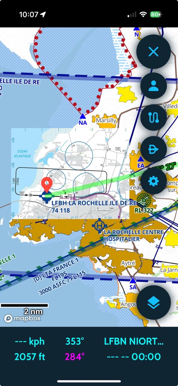
Coverage: Artic, France, British Isles, Eastern Europe, Iberia, Balkans, Italia, Scandinavia, Central Europe
Features:
- Application in English or French
- Home made Europe vector map
- Day and night styles
- Remove upper airspaces with a ceiling filter
- Traditional SDICAO map still available
- Free ICAO additional maps (14 countries)
- Chargeable maps available (see shop at https://skydreamsoft.fr)
- Online maps (plan, terrain, satellite, hybrid)
- Use your maps in MBTiles format
- Use your map layers (KML, GeoJSON, SHP)
- Display several maps simultaneously
- Change maps according to zoom
- Manage your custom waypoints
- Georeferenced VAC maps (automatic zoom mode)
- GPS tracking (speed vector & time bubbles)
- Be alerted in the event of loss of GPS or traffic stream (GDL90)
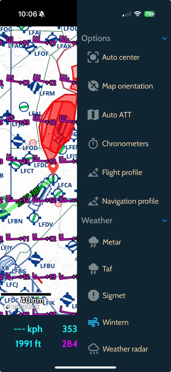
- Estimation of wind aloft
- Height estimation (accurate terrain model)
- Magnetic declination
- Map options (auto-center, orientation)
- Direct function (including localities search)
- Live track
- Replay tracks
- Customisable black box
- Export of tracks in KML and GPX formats
- 2D and 3D track display
- Stopwatches
- VFR & IFR Notams
- Zones from SUPAIP
- RTBA (very low altitude network) activations
- Double-tap airspace details
- Flight profile
- Navigation profile
- Create your navigations in just a few clicks
- Configurable flight log
- Take into account climb/descent times
- Drift and effective wind taken into account
- Overlaps (radio navigation)
- Help with choosing frequencies
- Export and import of GPX, KML, PLN (Flight Simulator) and FPL (Garmin) navigations
- METAR & TAF & SIGMET (raw and decoded)
- Wintems (18 levels and 24-hour forecasts)
- WINTEM and TEMSI weather maps from Météo-France
- Weather radar
- Data sheets for your aircraft
- Weight and balance screen
- Fuel estimates
- Narrow route briefing (weather, airfields and notams on your route)
- Generation of complete flight report
- French documentation (VAC, AIP, ULM, SUP AIP, FFA ICARUS)
- Load your personal documents and associate them with custom waypoints
- Library of VFR & weather guides, map supplements, legends, etc.
- Replace GPS with your flight simulator (FS2020/4, FSX, P3D, X-Plane, FlightGear, AeroFly)
- Use SafeSky or your traffic detection unit with GDL90
- Synchronise navigations, aircraft, custom points and tracks between your devices
- Numerous customisation options!
Accessibility
ipadiphonemacrealityDevicetvoswatch
Version history 25 versions
Build 887786601v1.3842026-07-04 05:12:54
- CG points can now have a weight/mass of 0 in the aircraft add/edit form.
Build 887089979v1.3832026-06-17 19:16:48
- Aligning filenames for Trace and Navigation exports.
- Fixed an issue where aircraft points could be duplicated under certain conditions.
Build 886669096v1.3822026-06-08 19:13:13
- Migrated dependency management from CocoaPods to Swift Package Manager.
- Major performance improvements to navigation profile computation.
- Fixed buffer calculation (UTM SRID) and reduced trace extrusion from 40 m to 30 m.
- Display the Update Document button only when relevant.
Build 885862394v1.382026-05-19 22:28:34
- Fixed an issue with vector layer configuration when disabling a raster basemap while one or more other basemaps were still displayed.
- Fixed the yellow label color for user waypoints.
- Fixed the list of user waypoint types being empty immediately after import.
Build 884600231v1.372026-04-16 22:12:34
- Fixed a cache issue when updating an alternative map
Build 883750863v1.362026-03-25 19:11:43
- Ability to apply a different wintem slot to the flight log
- Improved sorting of airfield features in the "Route" tab
- Option to rename a personal document (long press)
- French translation of "Scratch Pad" to "Bloc note"
Build 883542996v1.352026-03-19 18:46:21
- Automatic refresh of temporary airspace after an update
- Fixed an issue with automatic temporary airspace when the time format is set to 12-hour mode
- Navigation point notes are now saved continuously
- Fixed widget display issues on iPad
Build 883462566v1.342026-03-17 18:50:19
- Fixed an issue where an AIP document could remain stuck on an old version if the download failed.
- Removed the Weather Charts tab from the Account/Profile section.
- Attempted to fix a non-reproducible issue where the METAR/TAF widget would not update.
- Fixed the maximum zoom level of the weather radar, which could display a loading tile error at higher zoom levels.
- Changed temporary airspace color to magenta.
- Exposed the automatic temporary airspace opacity setting.
- Added an auto-zoom button to the Temporary Airspace search view.
Build 882633026v1.332026-02-21 01:15:48
- Fixed weirdness of Apple build.
Build 882602934v1.322026-02-20 00:12:14
- Fixed an issue with the shape and color of imported v1 user waypoints
- Fixed an issue where the route NOTAM list became desynchronized after filter changes
- Fixed a memory leak in the route NOTAM list
Build 882505175v1.312026-02-16 20:02:53
- Hiding weather radar type selector
- On logout stopping properly all services and restarting them on login
- Fixing translations on file import alerts
Build 882321819v1.302026-02-10 20:41:07
- Added a search bar and date filters to the trace list
- Mapbox 11.8.1: seems to fix the issue where speed vector bubbles would occasionally disappear or display incorrect values
- Improved handling of synchronization locking for user waypoints
- Added an alert when a file import fails
- Clearer enforcement of GPS location initialization at application startup
- Performance optimizations
Build 881525699v1.292026-01-15 22:22:10
- Tentative crash fix: Unsafe synchronous in DynamicDataManager
- Set tracking privacy setting to disabled at app start
- Tentative crash fix: nearestOnNavigationFrom (index 0 on spatialdatabase)
- Tentative crash fix: drawSpeedVector (convertion to Int failed because of value going over Int.max)
- Fix issue with external keyboard on FuelBalance form
- Web tracking rework
- Some translation fixes
Build 881213730v1.282026-01-05 23:58:53
- Fix a crash when 2 nav points are very close to each other and inside an airspace with height limit
- Fix tentative: specialized Array.remove(at) when deleting multiple navPoint in the feature popup list
- Sim mode is now disabled at each restart
- Fix wind conversion in bottom bar (Datablock)
- Automatically moving all PDF from root folder to userPersonalFolder
- Fixed the display order of active and inactive NOTAMs
Build 880712504v1.272025-12-16 23:06:01
- Fixed an SQLite crash during elevation database access.
Build 880061229v1.262025-11-25 19:10:17
- Fixing graphical notam display order to have the active one on top
- Allowing to set the bottom bar height to a minimum of 40pt
- Fixing FlightGear Simulator location
- Fixing saturated yellow color on user waypoint
Build 879727766v1.252025-11-13 20:39:35
- Moved all settings (cog) buttons to the left side to prevent overlap with the recently relocated close button.
- Harmonized all keyboards across the app for a consistent input experience.
- Removed unnecessary dividers in lists for a cleaner look.
- Optimized navigation profile computations.
- Optimized temporary airspace import performance.
- Fixed an issue where import alerts (Trace / Nav / MBTiles / PDF) were not displayed after a previous import.
- Fixed weight & balance not being computed or included in the flight record after loading a navigation.
- Harmonized descriptions shown when double-tapping NOTAM results (e.g. in NOTAM route view).
- Updated to SpatiaLite 5.1.
Build 879485552v1.242025-11-05 01:40:31
- Hotfix : Fixed an app crash at startup caused by duplicate temporary airspaces when multiple regions are installed.
Build 879417111v1.232025-11-04 00:34:37
- Graphical notams
- New option to hide the Q line of notams
- Simplified style for automatic or manual temporary areas
- Improved cache management after map updates
- Corrections
Build 879077443v1.222025-10-21 11:31:36
- Added distance-based and time-based throttling for QNH metric updates.
- Fixed documentation not updating after being postponed.
- Fixed location service not starting at app launch when Safesky is running first.
- Fixed VAC GEO/PDF auto-download getting stuck when having already downloaded some of the GEOVAC or PDF for the same airport.
- Removed duplicate Nav Export button.
- Fixed trace items reappearing in the list after deletion.
- Moved the red close button to the top-right corner of views.
Build 878744358v1.212025-10-08 19:47:25
- Hotfix: Fixed a crash occurring on first launch after a new installation.
- Fixed an issue preventing region deletion.
- Fixed an issue preventing the user waypoint list view from closing after creating or updating a user waypoint.
Build 878696292v1.202025-10-07 16:27:27
- Fixing unit issue on the Add/Edit Aircraft form view for stations.
- Fixing issue when peristing/updating an aircraft.
Build 878642575v1.192025-10-04 22:00:47
- Widget (You can find the settings in the general settings at the very end)
- Adding bottom bar data metric "QNH" and "Frequency"
- Fix issue when loading a nav and the close view button (red cross) did not appear to close the nav log
- Fix issue when skipping general update and not being notified to update after app restart
- FIx Metar/Taf secondary color display
- Adding current waypoint info view (disabled by default. To be enabled in the general setting above "Light Mode")
Build 878519681v1.182025-09-30 13:59:09
- Scratch Pad (can only be activated in the quick access menu in the top bar)
- Fix traffic altitude relative to current altitude
- Adding option to display nav point label
- Smarter synchronisation delay if multiple user actions
- Better synchronisation management when saving an aircraft
- Dynamic dotted line (leash) between the aircraft and the current point
- VAC buttons verically placed on the left on landscape
- Wind display is now reactive to the aircraft unit (nav log and bottom bar metric and mapclick)
- Devices are notified after a flight report has been generated and it is automatically downloaded to personal documents
- Fix app beeing frozen after quickly and multiple time triggering open/close sheet/view
- Fix iOS26 horizontal navigation profile not being scrollable
- Disabling all custom sheet animation on iOS 16 for better compatibility
Build 878201009v1.172025-09-18 07:52:53
- Fix ceiling filter slider and app load crash for iOS26
- Adding confirmation alert when removing a nav/user waypoint from the map
- Adding 'street' geocoding search in direct to enable the search of a street without using a number
- Adding filter geocoding/locality in direct
- Changing timeout of geocoding search to 5s
- Disabling alternate reserve field if an alternate airport is selected
- Fix alternate list not using the proper semi corridor parameter
- Filter airport notams by active date
No pricing data captured yet — comparisons appear once the app has paid storefronts or in-app purchases.
Availability 44 of 175 storefronts
| Region | Language | Price | Ratings | Avg | Version |
|---|---|---|---|---|---|
| FR | fr-FR | Free | 78 | 4.1 | 1.384 |
| BG | en-GB | Free | 1 | 5.0 | 1.384 |
| CH | de-CH | Free | 1 | 5.0 | 1.384 |
| AL | en-GB | Free | 0 | — | 1.384 |
| AT | de-DE | Free | 0 | — | 1.384 |
| BA | en-GB | Free | 0 | — | 1.384 |
| BE | en-GB | Free | 0 | — | 1.384 |
| BY | en-GB | Free | 0 | — | 1.384 |
| CA | en-CA | Free | 0 | — | 1.384 |
| CY | en-GB | Free | 0 | — | 1.384 |
| CZ | en-GB | Free | 0 | — | 1.384 |
| DE | de-DE | Free | 0 | — | 1.384 |
| DK | en-GB | Free | 0 | — | 1.384 |
| EE | en-GB | Free | 0 | — | 1.384 |
| ES | es-ES | Free | 0 | — | 1.384 |
| FI | en-GB | Free | 0 | — | 1.384 |
| GB | en-GB | Free | 0 | — | 1.384 |
| GR | en-GB | Free | 0 | — | 1.384 |
| HR | en-GB | Free | 0 | — | 1.384 |
| HU | en-GB | Free | 0 | — | 1.384 |
| IE | en-GB | Free | 0 | — | 1.384 |
| IS | en-GB | Free | 0 | — | 1.384 |
| IT | it | Free | 0 | — | 1.384 |
| LT | en-GB | Free | 0 | — | 1.384 |
| LU | en-GB | Free | 0 | — | 1.384 |
| LV | en-GB | Free | 0 | — | 1.384 |
| MD | en-GB | Free | 0 | — | 1.384 |
| ME | en-GB | Free | 0 | — | 1.384 |
| MK | en-GB | Free | 0 | — | 1.384 |
| MT | en-GB | Free | 0 | — | 1.384 |
| NL | nl | Free | 0 | — | 1.384 |
| NO | en-GB | Free | 0 | — | 1.384 |
| PL | en-GB | Free | 0 | — | 1.384 |
| PT | pt-PT | Free | 0 | — | 1.384 |
| RO | en-GB | Free | 0 | — | 1.384 |
| RS | en-GB | Free | 0 | — | 1.384 |
| RU | ru | Free | 0 | — | 1.384 |
| SE | sv | Free | 0 | — | 1.384 |
| SI | en-GB | Free | 0 | — | 1.384 |
| SK | en-GB | Free | 0 | — | 1.384 |
| TR | en-GB | Free | 0 | — | 1.384 |
| UA | en-GB | Free | 0 | — | 1.384 |
| US | en-US | Free | 0 | — | 1.384 |
| XK | en-GB | Free | 0 | — | 1.384 |
Not available in: AE, AF, AG, AI, AM, AO, AR, AU, AZ, BB, BF, BH, BJ, BM, BN, BO, BR, BS, BT, BW, BZ, CD, CG, CI, CL, CM, CN, CO, CR, CV, DM, DO, DZ, EC, EG, FJ, FM, GA, GD, GE, GH, GM, GT, GW, GY, HK, HN, ID, IL, IN, IQ, JM, JO, JP, KE, KG, KH, KN, KR, KW, KY, KZ, LA, LB, LC, LK, LR, LY, MA, MG, ML, MM, MN, MO, MR, MS, MU, MV, MW, MX, MY, MZ, NA, NE, NG, NI, NP, NR, NZ, OM, PA, PE, PG, PH, PK, PW, PY, QA, RW, SA, SB, SC, SG, SL, SN, SR, ST, SV, SZ, TC, TD, TH, TJ, TM, TN, TO, TT, TW, TZ, UG, UY, UZ, VC, VE, VG, VN, VU, YE, ZA, ZM, ZW
Change log 28 changes · CA
✎
releaseNotes updated
- CG points can now have a weight/mass of 0 in the aircraft add/edit form.
✎
description updated
This application is designed for pilots of aircraft operating under visual flight rules (VFR).
Coverage: Artic, France, British Isles, Eastern Europe, Iberia,
✎
name updated
SDVFR Next
◆
Version 1.384 released
- CG points can now have a weight/mass of 0 in the aircraft add/edit form.
◆
Version 1.383 released
- Aligning filenames for Trace and Navigation exports.
- Fixed an issue where aircraft points could be duplicated under certain conditions.
◆
Version 1.382 released
- Migrated dependency management from CocoaPods to Swift Package Manager.
- Major performance improvements to navigation profile computation.
- Fixed buffer calculation (UTM SRID) and reduced trace extrusion from 40 m to 30 m.
- Display the
◆
Version 1.38 released
- Fixed an issue with vector layer configuration when disabling a raster basemap while one or more other basemaps were still displayed.
- Fixed the yellow label color for user waypoints.
- Fixed the list of user waypoint types being empty i
◆
Version 1.37 released
- Fixed a cache issue when updating an alternative map
◆
Version 1.36 released
- Ability to apply a different wintem slot to the flight log
- Improved sorting of airfield features in the "Route" tab
- Option to rename a personal document (long press)
- French translation of "Scratch Pad" to "Bloc note"
◆
Version 1.35 released
- Automatic refresh of temporary airspace after an update
- Fixed an issue with automatic temporary airspace when the time format is set to 12-hour mode
- Navigation point notes are now saved continuously
- Fixed widget display issues on iP
◆
Version 1.34 released
- Fixed an issue where an AIP document could remain stuck on an old version if the download failed.
- Removed the Weather Charts tab from the Account/Profile section.
- Attempted to fix a non-reproducible issue where the METAR/TAF widget wo
◆
Version 1.33 released
- Fixed weirdness of Apple build.
◆
Version 1.32 released
- Fixed an issue with the shape and color of imported v1 user waypoints
- Fixed an issue where the route NOTAM list became desynchronized after filter changes
- Fixed a memory leak in the route NOTAM list
◆
Version 1.31 released
- Hiding weather radar type selector
- On logout stopping properly all services and restarting them on login
- Fixing translations on file import alerts
◆
Version 1.30 released
- Added a search bar and date filters to the trace list
- Mapbox 11.8.1: seems to fix the issue where speed vector bubbles would occasionally disappear or display incorrect values
- Improved handling of synchronization locking for user wayp
◆
Version 1.29 released
- Tentative crash fix: Unsafe synchronous in DynamicDataManager
- Set tracking privacy setting to disabled at app start
- Tentative crash fix: nearestOnNavigationFrom (index 0 on spatialdatabase)
- Tentative crash fix: drawSpeedVector (conv
◆
Version 1.28 released
- Fix a crash when 2 nav points are very close to each other and inside an airspace with height limit
- Fix tentative: specialized Array.remove(at) when deleting multiple navPoint in the feature popup list
- Sim mode is now disabled at each
◆
Version 1.27 released
- Fixed an SQLite crash during elevation database access.
◆
Version 1.26 released
- Fixing graphical notam display order to have the active one on top
- Allowing to set the bottom bar height to a minimum of 40pt
- Fixing FlightGear Simulator location
- Fixing saturated yellow color on user waypoint
◆
Version 1.25 released
- Moved all settings (cog) buttons to the left side to prevent overlap with the recently relocated close button.
- Harmonized all keyboards across the app for a consistent input experience.
- Removed unnecessary dividers in lists for a clea
◆
Version 1.24 released
- Hotfix : Fixed an app crash at startup caused by duplicate temporary airspaces when multiple regions are installed.
◆
Version 1.23 released
- Graphical notams
- New option to hide the Q line of notams
- Simplified style for automatic or manual temporary areas
- Improved cache management after map updates
- Corrections
◆
Version 1.22 released
- Added distance-based and time-based throttling for QNH metric updates.
- Fixed documentation not updating after being postponed.
- Fixed location service not starting at app launch when Safesky is running first.
- Fixed VAC GEO/PDF auto-d
◆
Version 1.21 released
- Hotfix: Fixed a crash occurring on first launch after a new installation.
- Fixed an issue preventing region deletion.
- Fixed an issue preventing the user waypoint list view from closing after creating or updating a user waypoint.
◆
Version 1.20 released
- Fixing unit issue on the Add/Edit Aircraft form view for stations.
- Fixing issue when peristing/updating an aircraft.
◆
Version 1.19 released
- Widget (You can find the settings in the general settings at the very end)
- Adding bottom bar data metric "QNH" and "Frequency"
- Fix issue when loading a nav and the close view button (red cross) did not appear to close the nav log
- Fi
◆
Version 1.18 released
- Scratch Pad (can only be activated in the quick access menu in the top bar)
- Fix traffic altitude relative to current altitude
- Adding option to display nav point label
- Smarter synchronisation delay if multiple user actions
- Better s
◆
Version 1.17 released
- Fix ceiling filter slider and app load crash for iOS26
- Adding confirmation alert when removing a nav/user waypoint from the map
- Adding 'street' geocoding search in direct to enable the search of a street without using a number
- Addin