Home › Navigation

 US
US
USen-US GBen-GB
 CAen-CA
 DEde-DE
 GRen-GB
 SBen-GB
 AEen-GB
 AFen-GB
 AGen-GB
 AIen-GB
 ALen-GB
 AMen-GB
 AOen-GB
 ARes-MX
 ATde-DE
 AUen-AU
 AZen-GB
 BAen-GB
 BBen-GB
 BEen-GB
 BFen-GB
 BGen-GB
 BHen-GB
 BJen-GB
 BMen-GB
 BNen-GB
 BOes-MX
 BRpt-BR
 BSen-GB
 BTen-GB
 BWen-GB
 BYen-GB
 BZen-GB
 CDen-GB
 CGen-GB
 CHde-CH
 CIfr-FR
 CLes-MX
 CMfr-FR
 CNzh-Hans-CN
 COes-MX
 CRes-MX
 CVen-GB
 CYen-GB
 CZen-GB
 DKen-GB
 DMen-GB
 DOes-MX
 DZen-GB
 ECes-MX
 EEen-GB
 EGen-GB
 ESes-ES
 FIen-GB
 FJen-GB
 FMen-GB
 FRfr-FR
 GAfr-FR
 GDen-GB
 GEen-GB
 GHen-GB
 GMen-GB
 GTes-MX
 GWen-GB
 GYen-GB
 HKzh-Hant-HK
 HNes-MX
 HRen-GB
 HUen-GB
 IDen-GB
 IEen-GB
 ILen-GB
 INen-GB
 IQen-GB
 ISen-GB
 ITit
ITit JMen-GB
 JOen-GB
 JPja
JPja KEen-GB
 KGen-GB
 KHen-GB
 KNen-GB
 KRko
KRko KWen-GB
 KYen-GB
 KZen-GB
 LAen-GB
 LBen-GB
 LCen-GB
 LKen-GB
 LRen-GB
 LTen-GB
 LUen-GB
 LVen-GB
 LYen-GB
 MAen-GB
 MDen-GB
 MEen-GB
 MGen-GB
 MKen-GB
 MLen-GB
 MMen-GB
 MNen-GB
 MOzh-Hant-HK
 MRen-GB
 MSen-GB
 MTen-GB
 MUen-GB
 MVen-GB
 MWen-GB
 MXes-MX
 MYen-GB
 MZen-GB
 NAen-GB
 NEen-GB
 NGen-GB
 NIes-MX
 NLnl
NLnl NOen-GB
 NPen-GB
 NRen-GB
 NZen-AU
 OMen-GB
 PAes-MX
 PEes-MX
 PGen-GB
 PHen-GB
 PKen-GB
 PLen-GB
 PTpt-PT
 PWen-GB
 PYes-MX
 QAen-GB
 ROen-GB
 RSen-GB
 RUru
RUru RWen-GB
 SAen-GB
 SCen-GB
 SEsv
SEsv SGen-GB
 SIen-GB
 SKen-GB
 SLen-GB
 SNen-GB
 SRen-GB
 STen-GB
 SVes-MX
 SZen-GB
 TCen-GB
 TDen-GB
 THen-GB
 TJen-GB
 TMen-GB
 TNen-GB
 TOen-GB
 TRen-GB
 TTen-GB
 TWzh-Hant-TW
 TZen-GB
 UAen-GB
 UGen-GB
 UYen-GB
 UZen-GB
 VCen-GB
 VEes-MX
 VGen-GB
 VNen-GB
 VUen-GB
 XKen-GB
 YEen-GB
 ZAen-GB
 ZMen-GB
 ZWen-GB
175 of 175 storefronts
Content in en-US
Content in en-US
Information
Preview 3 platforms
iPhone 10 images





iPad 9 images


Apple Watch 6 images


What’s New Version 5.5.4
Satellite view improvements, larger own boat symbol, configurable sog and cog vectors for own boat and other ships.
SeaNav autoroute:
Set start and end point for a route and let SeaNav propose a route and waypoints including the ICW
SeaNav AutoPilot:
Navigate routes automatically. SeaNav can now remotely control Raymarine and Navico/Simrad/Lowrance Auto tillers and helms. You can also use the free SeaNav Apple Watch app to control a Raymarine autohelm and tiller from your wrist.
iOS 26 updates.
Description
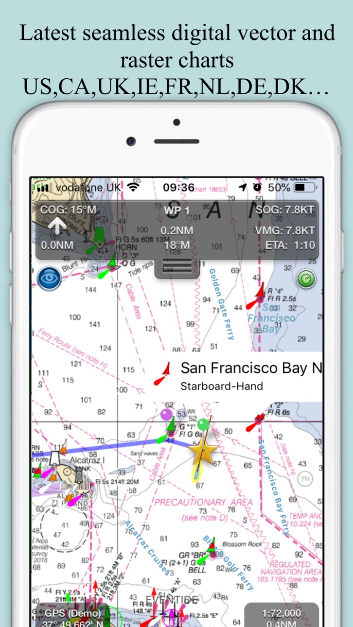
Explore, Plan and Navigate your boating trips in real time and outstanding high-resolution with the latest NOAA Marine charts covering the USA and US Great Lakes.
- Includes all US Coastal, ICW, Inland (USACE) and Great Lakes Digital Vector Charts
- Buoys, lights etc. are tappable with bearing and distance
- Free Apple Watch app
- Live AIS Ship targets and collision alerts (requires Boat Beacon)
- Seamless panning and zooming across charts
- Unique live Augmented Reality camera view
- Route Planning and tracking with Waypoints, ETA, XTE, etc. plus SeaNav autorouting
- Offline charts
- Route export and import to MFDs and other apps via gpx
- ActiveCaptain Marinas, Anchorage, Hazards and reviews
- US NOAA Raster charts available via IAP
- Canadian charts via IAP
- British Virgin Islands & Bermuda charts via IAP
- External NMEA over Wifi
SeaNav uses Digital Vector charts providing a wealth of benefits and advantages. Buoys, Lights, Bridges, Depth Contours, Depth Soundings, Rocks, Anchorage areas, NOAA Weather Buoys etc. are all selectable and have real time distance, bearing and detail information. Turn off layers to de-clutter the display and only show what is important at the time. Tides, moon and sun times and weather are also all available at your fingertips.
SeaNav’s unique AR view mode allows you to view buoys, lights, ships, waypoints and track overlaid on your iPhone or iPad live camera view. With "AR LockOn" you can select a target on the chart and then be guided to it in the AR camera view.
SeaNav lets you measure distances and bearings and record waypoints on routes. When at sea, the app’s Sailing HUD shows your position, Course over ground (COG), Speed over ground (SOG), Vector Made Good (VMG), Estimated Time of Arrival (ETA), Distance and bearing to next Waypoint. Waypoint reached alerts, auto-routing to the next waypoint and collision alerts.
SeaNav comes with a free Apple Watch companion app .
Lowrance, Simrad and B&G GoFree support included.
Your purchase of SeaNav includes 12 months of free updates to the included US chart set. Further chart updates are then available via an in-app purchase. Charts for other regions including Canada may also be added to your product via optional in-app purchase.
Our in-app purchases are 1 year subscriptions, which automatically renew at the end of the subscription period unless auto-renew is turned off at least 24-hours before the end of the current period. Payment will be charged to your iTunes Account at confirmation of purchase, and will be charged for renewal within 24-hours prior to the end of the current period. Pricing for our 1 year US Charts update subscription is US$9.99.
Subscriptions may be managed by the iTunes account holder and auto-renewal may be turned off by going to Account Settings after purchase.
No cancellation of the current subscription is allowed during active subscription period.
Our Privacy Policy may be accessed via http://seanav.net/privacy.php
Requires iPhone or iPad. GPS only required for real time route navigation. Optional Real time AIS, Tides and Weather information require an active internet connection.
iPhone devices and iPads with a cellular modem already have a built-in GPS, even if they do not have an active service plan.
If you have a WiFi-only iPad you will need an external GPS receiver or GPS feed to enable navigation.
Please note that continued use of GPS running in the background can dramatically decrease battery life.
NOT FOR NAVIGATION
This program is distributed in the hope that it will be useful. SeaNav should only be used for basic navigation reference and should not be solely relied upon to determine precise locations, proximity, distance, or direction.
Terms of Use: http://seanav.net/termsofuse.php
Privacy Policy: http://seanav.net/privacy.php
Support: help@pocketmariner.com
Third Party Licenses and Notices
NOTICE: US Marine Charts are derived from official NOAA Electronic Navigational Charts.
In-App Purchases US pricing
Bermuda & British Virgin Island Charts Subscription
Bermuda and BVI Charts · Yearly$12.99
Canada Charts Subscription
Yearly$29.99
NOAA US Raster charts Subscription
Yearly 1-month free trial$9.99
UK Charts Subscription
Yearly$13.99
US Chart Updates Subscription
Yearly$19.99
Weather forecasts Subscription
Weather charts · Yearly$7.49
One-Time Purchases
Man Overboard & Anchor Watch$4.99
Capabilities
In-App Purchases
Accessibility
ipadiphonemacrealityDevicetvoswatch
Version history 25 versions
Build 886207079v5.5.42026-06-01 09:18:56
Satellite view improvements, larger own boat symbol, configurable sog and cog vectors for own boat and other ships.
SeaNav autoroute:
Set start and end point for a route and let SeaNav propose a route and waypoints including the ICW
SeaNav AutoPilot:
Navigate routes automatically. SeaNav can now remotely control Raymarine and Navico/Simrad/Lowrance Auto tillers and helms. You can also use the free SeaNav Apple Watch app to control a Raymarine autohelm and tiller from your wrist.
iOS 26 updates.
Build 880601439v5.5.12026-03-16 09:35:10
SeaNav autoroute:
Set start and end point for a route and let SeaNav propose a route and waypoints including the ICW
SeaNav AutoPilot:
Navigate routes automatically. SeaNav can now remotely control Raymarine and Navico/Simrad/Lowrance Auto tillers and helms. You can also use the free SeaNav Apple Watch app to control a Raymarine autohelm and tiller from your wrist.
iOS 26 updates.
Build 878324669v5.4.202025-09-23 09:10:37
Improved ruler UI :- endpoints now easier to select & drag and magnifier view added to show what's under your finger for more exact placement.
Improvements to offline handling.
Battery level indicator for iPhone landscape mode
Time sensitive alerts for anchor watch and CPA.
Build 875529008v5.4.182025-06-12 10:36:09
Weather forecast overlay with animated Wind, Waves and currents for next 7 days (IAP)
Chart update improvements
Build 873001417v5.4.162025-03-06 13:02:24
Man overboard (MOB) and Anchor Watch features added (IAP).
-Anchor Watch alerts if drifted more than the anchor length or dirfts at more than 1 Knot
-MOB and Anchor buttons on the mainscreen top left (can be turned off in settings)
-MOB distance, bearing and time in water displayed
-MOB takes priority over Anchor Watch
-Anchor Watch also provides an email alert with a map
-SeaNav remains in sailing mode when MOB or Anchor are cleared.
- Check the userguide for more information about using Anchor Watch and Man Overboard
Build 872623505v5.4.152025-02-19 15:35:38
Tide stations and tide currents now available for the US.
Build 871202001v5.4.122024-12-20 10:59:53
UI Improvements
Update for iOS18
Build 866742866v5.4.92024-06-17 09:35:14
UI Improvements and fixes
-Quick Link to Boat Beacon button added (top right) - Boat Beacon also has a quick link back to SeaNav
-Request to launch Boat Beacon on start sailing now defaulted to not show( re-enable in Advanced settings or just use the new Boat Beacon quick link button).
-iPhone landscape mode now also displays current time
-iPad instruments side panel in landscape displays time
-SART TEST targets no longer fire an alarm
-Weather map now scrolls up and down
Build 855897602v5.4.52024-01-10 15:33:37
Fix for updatable charts that have not been updated not displaying if SeaNav is not connected to the internet.
Build 855561782v5.4.22023-03-20 09:59:59
Apple Watch App greatly improved Nav, Waypoint, Map ,CPA Alerts & new real time wind display
My Boat Details now lets you set the type - e.g. Sail, Pleasure, Fishing.
Own boat icon now bigger so more easily viewed and colour shows boat type.
Bridges, Shoreline and Traffic zones UI improvements
Flashing light patterns updated for South Cardinals
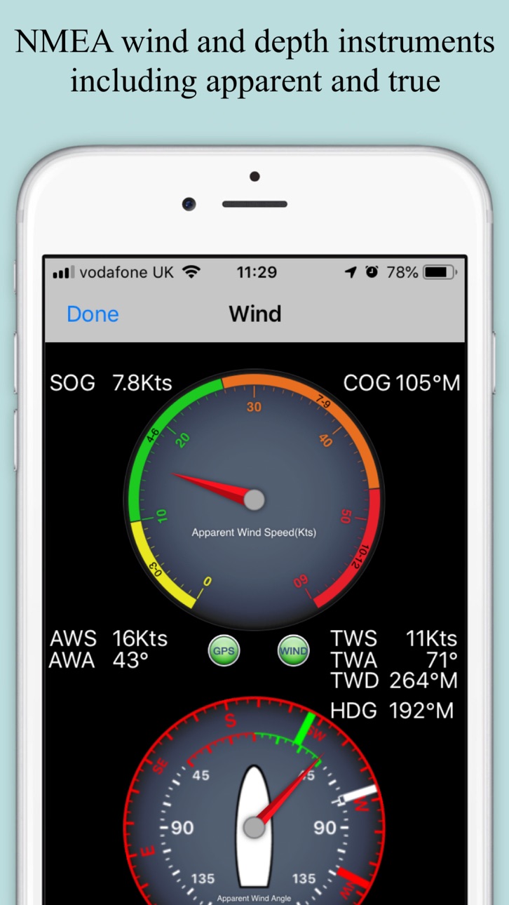
Realtime local wind instrument using SeaNav's Weather feed (IAP) or NMEA over Wifi
Improved Instruments for Nav (inc. Depth), Waypoints & Wind
Export tracks and routes as GPX (e.g to MFDs, Chart plotters and Navionics)
Export and import all POIs
Settings for Auto/Day/Night mode display
Notification sounds fixed
iOS16 ready
Build 848167404v5.42022-04-14 11:02:57
Apple Watch App greatly improved Nav, Waypoint, Map ,CPA Alerts & new real time wind display
Realtime local wind instrument using SeaNav's Weather feed (IAP) or NMEA over Wifi
Improved Instruments for Nav (inc. Depth), Waypoints & Wind
Export tracks and routes as GPX (e.g to MFDs, Chart plotters and Navionics)
Export and import all POIs
Settings for Auto/Day/Night mode display
iOS15 ready
Build 842425826v5.3.32021-06-16 17:02:23
Much faster chart drawing on newer Apple devices ( iPhone 9 and later and iPad 6th gen and later)
Support for iOS Dark mode - better for night time vision and use.
SeaNav iOS and its charts now works on the new MacBook M1.
Cardinal mark light patterns now displayed correctly in light details
Supports full screen width on new iPad Pros
Fix for Apple Watch app sometimes getting stuck
Build 840724297v5.3.12021-03-04 12:20:03
Much faster chart drawing on newer Apple devices ( iPhone 9 and later and iPad 6th gen and later)
Support for iOS Dark mode - better for night time vision and use.
SeaNav iOS and its charts now works on the new MacBook M1.
Cardinal mark light patterns now displayed correctly in light details
Build 831388890v5.12019-05-24 18:42:11
Support for iPhone X full screen - charts now go all the way to the edges.
Detailed animated weather forecast maps including wind, waves & pressure from now up to the 2 weeks ahead based on GFS model as used by NOAA and other leading Met Offices (IAP required).
Simulation mode lets you experience all the features for free.
UI improvements
Build 829104492v4.8.12018-10-31 09:42:58
Fix for SeaNav crashing when SeaNav Watch app is launched
Ship AIS Safety Messages now shown ( ship icon will flash if it is broadcasting a Type 14: Safety-Related Broadcast Message)
Collision detection Time to Collision and Distance collision guards can now be changed from the default of 200m in 10 minutes to any distance and time and can also be disabled by setting CPA Time to 0 - See Boat Details in SeaNav Settings..
POI Manage/Add new POI bug fix.
Fixes for using local AIS over Wifi for own boat location ( AIVDO message - speed and heading now correct)
Build 827620775v4.72018-07-13 09:14:30
Updated Apple Watch app including crown support and adjustable countdown timer.
Fixed Notifications and alerts for iOS and Watch.
Improved search function.
General UI fixes and updates.
GDPR updates
Build 823662594v4.32017-09-18 08:16:59
iOS11 ready.
NMEA Wind, Depth and Boat Speed instruments added.
Build 822854694v4.2.12017-07-12 08:08:22
Fix to re-enable location tracking in background when in Sailing Mode.
Fix for weather information.
4.2 added:-
Favourite Places (POIs):- Add markers for places you want to remember, add a photo and share them with friends too. Add fishing spots with a photo of the one that didn't get away, diving locations, cosy anchorages, hazards, reminders to call in on a VHF channel etc.
Air Draft: See if your boat will fit under a bridge or cable you are approaching in our unique augmented reality view.
Build 822694452v4.22017-06-28 15:48:16
Favourite Places (POIs):- Add markers for places you want to remember, add a photo and share them with friends too. Add fishing spots with a photo of the one that didn't get away, diving locations, cosy anchorages, hazards, reminders to call in on a VHF channel etc.
Air Draft: See if your boat will fit under a bridge or cable you are approaching in our unique augmented reality view.
Ruler for measuring bearings in AR mode when sailing.
Build 822425818v4.12017-06-07 08:52:57
Marine charts for the whole of Spain now available via IAP
Wind instruments added with support for NMEA Wind data via Wi-fi, GoFree and SailTimer ( http://pocketmariner.com/sailtimer ) via Bluetooth. Includes Apparent and True Wind direction and speed readouts. (update for new SailTimer API).
Apple Watch AIS support improvements.
Dropbox™ v2 support for route export and import
Build 819111018v3.8.32016-09-30 15:27:54
Wind instruments added with support for NMEA Wind data via Wi-fi, GoFree and SailTimer ( http://SailTimerWind.com/PocketMariner ) via Bluetooth. Includes Apparent and True Wind direction and speed readouts.(update for new API support).
US Caribbean and Panama Canal Charts now available in US chart set.
Apple Watch GoFree support improvements.
NOAA US Raster Charts IAP option, vector enhanced with tappable buoys/lights etc.
Fix for charts not downloading on iOS10 fresh install.
Build 817928229v3.8.22016-06-30 13:51:10
Wind instruments added with support for NMEA Wind data via Wi-fi, GoFree and SailTimer ( http://SailTimerWind.com/PocketMariner ) via Bluetooth. Includes Apparent and True Wind direction and speed readouts.(update for new API support).
US Caribbean and Panama Canal Charts now available in US chart set.
Apple Watch GoFree support improvements.
NOAA US Raster Charts IAP option, vector enhanced with tappable buoys/lights etc.
Build 817085432v3.82016-06-08 16:37:58
Wind instruments added with support for NMEA Wind data via Wi-fi, GoFree and SailTimer ( http://SailTimerWind.com/PocketMariner ) via Bluetooth. Includes Apparent and True Wind direction and speed readouts.
US Caribbean and Panama Canal Charts now available in US chart set.
Apple Watch GoFree support improvements.
NOAA US Raster Charts IAP option, vector enhanced with tappable buoys/lights etc.
Lock Gates with depths and widths (where available) now show.
Latest spring US Chart updates.
Apple Watch SeaNav app now supports local AIS via Wifi and GoFree.
Build 816748634v3.72016-03-24 23:15:46
NOAA US Raster Charts IAP option, vector enhanced with tappable buoys/lights etc.
Performance improvements
Lock gates now drawn
IALAB buoyage correctly drawn
Build 815116048v3.6.42016-01-05 10:03:43
Improved NMEA support for Wind, Depth and Waypoint information
AIS AtoN buoys and symbols with IALA A and B Buoyage.
Fix for routes not displaying after pressing the eye button.
iOS 9 ready
ActiveCaptain: Marinas, Anchorage, Local Knowledge and Hazards markers and details added. "The best quantity and quality of information available to boaters worldwide". Details on thousands of US and Canadian marinas, anchorages, hazards, local knowledge information, as well as, reviews from other boaters.
Apple Watch support. Check your navigation, waypoints and compass live directly on your Apple Watch from anywhere on your boat.
Navigation, Waypoint, Compass, AIS, Race Timer and Night Mode watch screens provided.
Watch Navigation shows real time SOG,COG,Lat and Long.
Check distance, bearing and time to your next waypoint together with cross track error with a glance at your wrist.
A compass with Course over ground or Heading and bearing to next waypoint. The heading is your true boats heading if your iPhone or iPad is laterally fixed to your boat.
Run a countdown timer to cross the starting line in prime position.
Get AIS alerts to potential collisions and check out the CPA bearing, distance and time to target on the map on your watch.
Price history by region
Currency
Show
Columns
Search
App performance US
Availability 175 of 175 storefronts
| Region | Language | Price | Ratings | Avg | Version |
|---|---|---|---|---|---|
| US | en-US | USD 19.99 | 100 | 4.3 | 5.5.4 |
| GB | en-GB | GBP 19.99 | 3 | 5.0 | 5.5.4 |
| CA | en-CA | CAD 24.99 | 1 | 5.0 | 5.5.4 |
| DE | de-DE | EUR 22.99 | 1 | 5.0 | 5.5.4 |
| GR | en-GB | EUR 22.99 | 1 | 5.0 | 5.5.4 |
| SB | en-GB | USD 19.99 | 1 | 5.0 | 5.5.4 |
| AE | en-GB | AED 79.99 | 0 | — | 5.5.4 |
| AF | en-GB | USD 19.99 | 0 | — | 5.5.4 |
| AG | en-GB | USD 19.99 | 0 | — | 5.5.4 |
| AI | en-GB | USD 19.99 | 0 | — | 5.5.4 |
| AL | en-GB | USD 22.99 | 0 | — | 5.5.4 |
| AM | en-GB | USD 22.99 | 0 | — | 5.5.4 |
| AO | en-GB | USD 19.99 | 0 | — | 5.5.4 |
| AR | es-MX | USD 19.99 | 0 | — | 5.5.4 |
| AT | de-DE | EUR 22.99 | 0 | — | 5.5.4 |
| AU | en-AU | AUD 29.99 | 0 | — | 5.5.4 |
| AZ | en-GB | USD 22.99 | 0 | — | 5.5.4 |
| BA | en-GB | EUR 22.99 | 0 | — | 5.5.4 |
| BB | en-GB | USD 22.99 | 0 | — | 5.5.4 |
| BE | en-GB | EUR 22.99 | 0 | — | 5.5.4 |
| BF | en-GB | USD 19.99 | 0 | — | 5.5.4 |
| BG | en-GB | EUR 22.99 | 0 | — | 5.5.4 |
| BH | en-GB | USD 19.99 | 0 | — | 5.5.4 |
| BJ | en-GB | USD 22.99 | 0 | — | 5.5.4 |
| BM | en-GB | USD 19.99 | 0 | — | 5.5.4 |
| BN | en-GB | USD 19.99 | 0 | — | 5.5.4 |
| BO | es-MX | USD 19.99 | 0 | — | 5.5.4 |
| BR | pt-BR | BRL 129.9 | 0 | — | 5.5.4 |
| BS | en-GB | USD 19.99 | 0 | — | 5.5.4 |
| BT | en-GB | USD 19.99 | 0 | — | 5.5.4 |
| BW | en-GB | USD 19.99 | 0 | — | 5.5.4 |
| BY | en-GB | USD 22.99 | 0 | — | 5.5.4 |
| BZ | en-GB | USD 19.99 | 0 | — | 5.5.4 |
| CD | en-GB | USD 19.99 | 0 | — | 5.5.4 |
| CG | en-GB | USD 19.99 | 0 | — | 5.5.4 |
| CH | de-CH | CHF 18 | 0 | — | 5.5.4 |
| CI | fr-FR | USD 22.99 | 0 | — | 5.5.4 |
| CL | es-MX | CLP 22990 | 0 | — | 5.5.4 |
| CM | fr-FR | USD 22.99 | 0 | — | 5.5.4 |
| CN | zh-Hans-CN | CNY 148 | 0 | — | 5.5.4 |
| CO | es-MX | COP 99900 | 0 | — | 5.5.4 |
| CR | es-MX | USD 19.99 | 0 | — | 5.5.4 |
| CV | en-GB | USD 19.99 | 0 | — | 5.5.4 |
| CY | en-GB | EUR 22.99 | 0 | — | 5.5.4 |
| CZ | en-GB | CZK 499 | 0 | — | 5.5.4 |
| DK | en-GB | DKK 179 | 0 | — | 5.5.4 |
| DM | en-GB | USD 19.99 | 0 | — | 5.5.4 |
| DO | es-MX | USD 19.99 | 0 | — | 5.5.4 |
| DZ | en-GB | USD 19.99 | 0 | — | 5.5.4 |
| EC | es-MX | USD 19.99 | 0 | — | 5.5.4 |
| EE | en-GB | EUR 22.99 | 0 | — | 5.5.4 |
| EG | en-GB | EGP 999.99 | 0 | — | 5.5.4 |
| ES | es-ES | EUR 22.99 | 0 | — | 5.5.4 |
| FI | en-GB | EUR 22.99 | 0 | — | 5.5.4 |
| FJ | en-GB | USD 19.99 | 0 | — | 5.5.4 |
| FM | en-GB | USD 19.99 | 0 | — | 5.5.4 |
| FR | fr-FR | EUR 22.99 | 0 | — | 5.5.4 |
| GA | fr-FR | USD 19.99 | 0 | — | 5.5.4 |
| GD | en-GB | USD 19.99 | 0 | — | 5.5.4 |
| GE | en-GB | USD 22.99 | 0 | — | 5.5.4 |
| GH | en-GB | USD 22.99 | 0 | — | 5.5.4 |
| GM | en-GB | USD 19.99 | 0 | — | 5.5.4 |
| GT | es-MX | USD 19.99 | 0 | — | 5.5.4 |
| GW | en-GB | USD 19.99 | 0 | — | 5.5.4 |
| GY | en-GB | USD 19.99 | 0 | — | 5.5.4 |
| HK | zh-Hant-HK | HKD 148 | 0 | — | 5.5.4 |
| HN | es-MX | USD 19.99 | 0 | — | 5.5.4 |
| HR | en-GB | EUR 22.99 | 0 | — | 5.5.4 |
| HU | en-GB | HUF 8990 | 0 | — | 5.5.4 |
| ID | en-GB | IDR 349000 | 0 | — | 5.5.4 |
| IE | en-GB | EUR 22.99 | 0 | — | 5.5.4 |
| IL | en-GB | ILS 69.9 | 0 | — | 5.5.4 |
| IN | en-GB | INR 1999 | 0 | — | 5.5.4 |
| IQ | en-GB | USD 19.99 | 0 | — | 5.5.4 |
| IS | en-GB | USD 22.99 | 0 | — | 5.5.4 |
| IT | it | EUR 22.99 | 0 | — | 5.5.4 |
| JM | en-GB | USD 19.99 | 0 | — | 5.5.4 |
| JO | en-GB | USD 19.99 | 0 | — | 5.5.4 |
| JP | ja | JPY 3000 | 0 | — | 5.5.4 |
| KE | en-GB | USD 22.99 | 0 | — | 5.5.4 |
| KG | en-GB | USD 19.99 | 0 | — | 5.5.4 |
| KH | en-GB | USD 19.99 | 0 | — | 5.5.4 |
| KN | en-GB | USD 19.99 | 0 | — | 5.5.4 |
| KR | ko | KRW 33000 | 0 | — | 5.5.4 |
| KW | en-GB | USD 19.99 | 0 | — | 5.5.4 |
| KY | en-GB | USD 19.99 | 0 | — | 5.5.4 |
| KZ | en-GB | KZT 11990 | 0 | — | 5.5.4 |
| LA | en-GB | USD 19.99 | 0 | — | 5.5.4 |
| LB | en-GB | USD 19.99 | 0 | — | 5.5.4 |
| LC | en-GB | USD 19.99 | 0 | — | 5.5.4 |
| LK | en-GB | USD 19.99 | 0 | — | 5.5.4 |
| LR | en-GB | USD 19.99 | 0 | — | 5.5.4 |
| LT | en-GB | EUR 22.99 | 0 | — | 5.5.4 |
| LU | en-GB | EUR 22.99 | 0 | — | 5.5.4 |
| LV | en-GB | EUR 22.99 | 0 | — | 5.5.4 |
| LY | en-GB | USD 19.99 | 0 | — | 5.5.4 |
| MA | en-GB | USD 19.99 | 0 | — | 5.5.4 |
| MD | en-GB | USD 22.99 | 0 | — | 5.5.4 |
| ME | en-GB | EUR 19.99 | 0 | — | 5.5.4 |
| MG | en-GB | USD 19.99 | 0 | — | 5.5.4 |
| MK | en-GB | USD 19.99 | 0 | — | 5.5.4 |
| ML | en-GB | USD 19.99 | 0 | — | 5.5.4 |
| MM | en-GB | USD 19.99 | 0 | — | 5.5.4 |
| MN | en-GB | USD 19.99 | 0 | — | 5.5.4 |
| MO | zh-Hant-HK | USD 19.99 | 0 | — | 5.5.4 |
| MR | en-GB | USD 19.99 | 0 | — | 5.5.4 |
| MS | en-GB | USD 19.99 | 0 | — | 5.5.4 |
| MT | en-GB | EUR 22.99 | 0 | — | 5.5.4 |
| MU | en-GB | USD 22.99 | 0 | — | 5.5.4 |
| MV | en-GB | USD 19.99 | 0 | — | 5.5.4 |
| MW | en-GB | USD 19.99 | 0 | — | 5.5.4 |
| MX | es-MX | MXN 399 | 0 | — | 5.5.4 |
| MY | en-GB | MYR 99.9 | 0 | — | 5.5.4 |
| MZ | en-GB | USD 19.99 | 0 | — | 5.5.4 |
| NA | en-GB | USD 19.99 | 0 | — | 5.5.4 |
| NE | en-GB | USD 19.99 | 0 | — | 5.5.4 |
| NG | en-GB | NGN 29900 | 0 | — | 5.5.4 |
| NI | es-MX | USD 19.99 | 0 | — | 5.5.4 |
| NL | nl | EUR 22.99 | 0 | — | 5.5.4 |
| NO | en-GB | NOK 249 | 0 | — | 5.5.4 |
| NP | en-GB | USD 22.99 | 0 | — | 5.5.4 |
| NR | en-GB | USD 19.99 | 0 | — | 5.5.4 |
| NZ | en-AU | NZD 39.99 | 0 | — | 5.5.4 |
| OM | en-GB | USD 19.99 | 0 | — | 5.5.4 |
| PA | es-MX | USD 19.99 | 0 | — | 5.5.4 |
| PE | es-MX | PEN 89.9 | 0 | — | 5.5.4 |
| PG | en-GB | USD 19.99 | 0 | — | 5.5.4 |
| PH | en-GB | PHP 1290 | 0 | — | 5.5.4 |
| PK | en-GB | PKR 4900 | 0 | — | 5.5.4 |
| PL | en-GB | PLN 99.99 | 0 | — | 5.5.4 |
| PT | pt-PT | EUR 22.99 | 0 | — | 5.5.4 |
| PW | en-GB | USD 19.99 | 0 | — | 5.5.4 |
| PY | es-MX | USD 19.99 | 0 | — | 5.5.4 |
| QA | en-GB | QAR 69.99 | 0 | — | 5.5.4 |
| RO | en-GB | RON 99.99 | 0 | — | 5.5.4 |
| RS | en-GB | EUR 22.99 | 0 | — | 5.5.4 |
| RU | ru | RUB 1790 | 0 | — | 5.5.4 |
| RW | en-GB | USD 19.99 | 0 | — | 5.5.4 |
| SA | en-GB | SAR 89.99 | 0 | — | 5.5.4 |
| SC | en-GB | USD 19.99 | 0 | — | 5.5.4 |
| SE | sv | SEK 249 | 0 | — | 5.5.4 |
| SG | en-GB | SGD 29.98 | 0 | — | 5.5.4 |
| SI | en-GB | EUR 22.99 | 0 | — | 5.5.4 |
| SK | en-GB | EUR 22.99 | 0 | — | 5.5.4 |
| SL | en-GB | USD 19.99 | 0 | — | 5.5.4 |
| SN | en-GB | USD 22.99 | 0 | — | 5.5.4 |
| SR | en-GB | USD 19.99 | 0 | — | 5.5.4 |
| ST | en-GB | USD 19.99 | 0 | — | 5.5.4 |
| SV | es-MX | USD 19.99 | 0 | — | 5.5.4 |
| SZ | en-GB | USD 19.99 | 0 | — | 5.5.4 |
| TC | en-GB | USD 19.99 | 0 | — | 5.5.4 |
| TD | en-GB | USD 19.99 | 0 | — | 5.5.4 |
| TH | en-GB | THB 699 | 0 | — | 5.5.4 |
| TJ | en-GB | USD 19.99 | 0 | — | 5.5.4 |
| TM | en-GB | USD 19.99 | 0 | — | 5.5.4 |
| TN | en-GB | USD 19.99 | 0 | — | 5.5.4 |
| TO | en-GB | USD 19.99 | 0 | — | 5.5.4 |
| TR | en-GB | TRY 999.99 | 0 | — | 5.5.4 |
| TT | en-GB | USD 19.99 | 0 | — | 5.5.4 |
| TW | zh-Hant-TW | TWD 690 | 0 | — | 5.5.4 |
| TZ | en-GB | TZS 59900 | 0 | — | 5.5.4 |
| UA | en-GB | USD 22.99 | 0 | — | 5.5.4 |
| UG | en-GB | USD 22.99 | 0 | — | 5.5.4 |
| UY | en-GB | USD 19.99 | 0 | — | 5.5.4 |
| UZ | en-GB | USD 19.99 | 0 | — | 5.5.4 |
| VC | en-GB | USD 19.99 | 0 | — | 5.5.4 |
| VE | es-MX | USD 19.99 | 0 | — | 5.5.4 |
| VG | en-GB | USD 19.99 | 0 | — | 5.5.4 |
| VN | en-GB | VND 599000 | 0 | — | 5.5.4 |
| VU | en-GB | USD 19.99 | 0 | — | 5.5.4 |
| XK | en-GB | EUR 22.99 | 0 | — | 5.5.4 |
| YE | en-GB | USD 19.99 | 0 | — | 5.5.4 |
| ZA | en-GB | ZAR 399.99 | 0 | — | 5.5.4 |
| ZM | en-GB | USD 22.99 | 0 | — | 5.5.4 |
| ZW | en-GB | USD 22.99 | 0 | — | 5.5.4 |
Reviews 30 reviews · US
★★★★★
AIS integration
The integration with my em-trak AIS receiver/transmitter is the killer feature. That lets me do heavy-duty nav/piloting in the iOS/WiFi universe rather than in some manufacturer's proprietary OS universe and the nichey, expensive, specialized marine networking universe.
Ted in NC2026-04-14
★★★★★
Removing ‘Crashes on open’ comment
SeaNav has always worked well for me but recently after updating my subscription it crashed on open for about 2 days on my iPhone 16. A reboot and reinstall did not help. However after this time the app works again. Upgrading review to 4 star but suggest not changing subscription during a stormy day out sailing.
Johnd442025-06-26
★★★★★
Deceptive
Product doesn’t allow you to try before it charges you and then refuses refund. Beware
Bobsully532025-06-06
★★★★★
Too basic
This app offers little more than a colorful map with a few icons. It is of zero use in navigation.
Sunrise462021-07-12
★★★★★
Very good navigation app
I’ve used SeaNav and Boat Beacon for six years, extensive offline use in British Columbia and Washington.
Of the six or seven IOS marine navigation apps I’ve owned, it’s the best and most enduring.
Well maintained and very responsive tech support.
MV Kinnikinnick2020-11-18
★★★★★
Waste of money can’t get a river depth it old version was free
Google maps is better
Danrprt2019-12-07
★★★★★
Not user friendly
Very difficult to use but have heard good things from other Captians
Capt. David S Hamilton2019-10-16
★★★★★
Not for iPhone!
I sail Alamitos Bay in Long Beach, CA. Although I have Anchorages layer OFF, the chart still indicates all anchorages. So many are shown that they overlap and are unreadable. On my iPhone 6 Plus, the chart is useless. Tech support claims that the anchorages are the names of the 'water areas' and will show even with the Anchorages layer turned OFF. $30 bucks out the window, as far as I'm concerned.
blazer6btf2015-04-04
★★★★★
Poor & slow
Crash & calibrate,seems that's all I do with this app. This app is not even good for recreational boating. Don't waste your time & money.
Pet Gear Depot2015-04-01
★★★★★
Crashed 5 times in the first 15 minutes - Yuk
Crashed so often that I couldn't even view harbors. Vey allow on my LTE iPad Mini.
Depth contours 0-18', 18-30', and 30-600'are less than ideal. I would want to navigate my boat using this app and its maps.
D_Snow2015-01-27
★★★★★
Good app but NO detailed depth contours for Tennessee River
I give it 5 stars because it is an intuitive app, and if you do any type of weekend trip on a cabin cruiser near the major bays, it's probably fine.
I like the fact that it pings GPS every minute when in background mode to save energy. I like the intuitive interface, and myriad options one can set.
Their tech support is great. I've been emailing them and they have done all they can to work with me, and even suggesting a refund. I appreciate a company like this but I did ask them to update their description to make sure people know about the Tennessee River depth contour issue.
I bought a com
Flexoffset2014-07-08
★★★★★
Snappy and helpful
The app is crisp and responsive on my 4th gen iPad -- and the AR feature was a huge help in confirming landmarks while sailing through the fog along the Monterey coast.
gschroder2013-11-12
★★★★★
Nice improvements
They keep working on this app and its become much better, performance is good on my iphone 5
SuperSaint20092013-11-11
★★★★★
Unusable
The charts draw soooooo slowly, this app is virtually unusable.
Appkiller4342013-11-08
★★★★★
Slow to the point of being unusable
The slightest move on the chart causes a 5-20 second wait for the map to redraw itself. Zooming out makes the map unreadable for at least as long. Simplifying the map only helps a little bit...still too slow to use.
The charts are way too busy graphically speaking-very hard to even find a channel with giant marker icons.
The only good thing is that is coordinates with boat beacon, a very good app.
Get Navionics. 1000 times better.
Layr Layr2013-10-17
★★★★★
Crashes frequently
I am running this app on an iPhone 5 with iOS 7. Since purchasing I haven't been able to use the app due to it crashing every time I open it. Please update your app to work with the new iOS or remove it from the App Store if you cannot support it.
JFNeal2013-10-04
★★★★★
Crashes!!!
when you set sail to a point it crashes and then you have to start all over. Adding spots should be simple but its not, (you should be able to tap in boat position and add your fav spot), zoom in out is app took a time to load or freezes!
Moemoe332013-09-29
★★★★★
Needs work
It would be a great app IF it would use iPad internal gps. At the moment it requires you to connect to external gps! How stupid is that?! I used version of this software back on PC. Back than I understood need of external gps. Not theses days. Please fix it. Meantime I will stick to iSailor.
Sailoresa2013-09-19
★★★★★
Awesome!
This app saved us last night in the fog. Got home safe thanks to this excellent app!
New boater2013-09-02
★★★★★
Misleading
App is suppose to cover all US charts yet none of the lakes in my area show up. In fact, none of the lakes in my state show up, and we are talking some rather large bodies of water. The only body of water to show up is a floodplain called little blue river which isn't even navigable, lol. App should correctly read only select US bodies of water, not ALL U.S. charts. Waste of $10. Navionics is much more complete.
Media-amp2013-08-30
★★★★★
Exceptional
Love the look and feel of the charts. Easy to read. Zoom in and out makes my onboard Raymarine software/equipment a relic. Use in conjunction with Boat Beacon (app). This will give you real time AIS!
Porter2013-08-17
★★★★★
SeaNav
Works best on iPad 3 with cellular/wifi as this iPad 3G has a GPS assisted capability whether connected or not to a cellular network.
IPad 2 wifi (no cellular) dees NOT have a GPS Satellite Receiver in them so you would need to add a GPS receiver to an iPad 2. I tried using a Verizon Hot Spot Cellular with iPad 2 and neither worked, nor did Apple Maps or Google Maps.
There are no cellular towers in the middle of Lake Michigan, so the triangulated cellular cannot function on a iPad 2. You end up sliding along the shoreline and never go out into the Lake. The same problem happens with Apple M
YOSWife2013-08-17
★★★★★
Very cool app!
I also have boat beacon that overlays AIS data on these nautical charts and its great to watch, especially during meetings when you'd rather be on the water :)
Kim berck2013-07-25
★★★★★
Self
Purchased app yesterday and initially worked perfectly, then my iPad wouldn't show position on SeaNAv. Strange. I emailed Steve Bennett @ Pocket Electric (the developer) and I had an email back from him this morning. There's a known bug in the llatest bersion of iOS software that prevents the iPad from accepting location from the extenral GPS (in my case, a Dual). The fix is on the iPad: (1) turn off location services on iPad; (2) reboot iPad; (3) wait 5 seconds and turn iPad on; (4) turn location services on. This may need to be done whenever the problem reappears. Let's hope Apple fixes this
OwlsHeadGuy2013-06-27
★★★★★
Amazing app
This app is truly amazing. It automatically couples with other apps, like the AIS beacon app, et al.
Cap'n Robert2013-06-20
Change log 29 changes · US
✎
releaseNotes updated
Satellite view improvements, larger own boat symbol, configurable sog and cog vectors for own boat and other ships.
SeaNav autoroute:
Set start and end point
✎
description updated
Explore, Plan and Navigate your boating trips in real time and outstanding high-resolution with the latest NOAA Marine charts covering the USA and US Great Lake
✎
subtitle updated
HD Marine Navigation & Charts
✎
name updated
SeaNav US
◆
Version 5.5.4 released
Satellite view improvements, larger own boat symbol, configurable sog and cog vectors for own boat and other ships.
SeaNav autoroute:
Set start and end point for a route and let SeaNav propose a route and waypoints including the ICW
Sea
◆
Version 5.5.1 released
SeaNav autoroute:
Set start and end point for a route and let SeaNav propose a route and waypoints including the ICW
SeaNav AutoPilot:
Navigate routes automatically. SeaNav can now remotely control Raymarine and Navico/Simrad/Lowrance A
◆
Version 5.4.20 released
Improved ruler UI :- endpoints now easier to select & drag and magnifier view added to show what's under your finger for more exact placement.
Improvements to offline handling.
Battery level indicator for iPhone landscape mode
Time sensitiv
◆
Version 5.4.18 released
Weather forecast overlay with animated Wind, Waves and currents for next 7 days (IAP)
Chart update improvements
◆
Version 5.4.16 released
Man overboard (MOB) and Anchor Watch features added (IAP).
-Anchor Watch alerts if drifted more than the anchor length or dirfts at more than 1 Knot
-MOB and Anchor buttons on the mainscreen top left (can be turned off in settings)
-MOB d
◆
Version 5.4.15 released
Tide stations and tide currents now available for the US.
◆
Version 5.4.12 released
UI Improvements
Update for iOS18
◆
Version 5.4.9 released
UI Improvements and fixes
-Quick Link to Boat Beacon button added (top right) - Boat Beacon also has a quick link back to SeaNav
-Request to launch Boat Beacon on start sailing now defaulted to not show( re-enable in Advanced settings or j
◆
Version 5.4.5 released
Fix for updatable charts that have not been updated not displaying if SeaNav is not connected to the internet.
◆
Version 5.4.2 released
Apple Watch App greatly improved Nav, Waypoint, Map ,CPA Alerts & new real time wind display
My Boat Details now lets you set the type - e.g. Sail, Pleasure, Fishing.
Own boat icon now bigger so more easily viewed and colour shows boat typ
◆
Version 5.4 released
Apple Watch App greatly improved Nav, Waypoint, Map ,CPA Alerts & new real time wind display
Realtime local wind instrument using SeaNav's Weather feed (IAP) or NMEA over Wifi
Improved Instruments for Nav (inc. Depth), Waypoints & Wind
Expo
◆
Version 5.3.3 released
Much faster chart drawing on newer Apple devices ( iPhone 9 and later and iPad 6th gen and later)
Support for iOS Dark mode - better for night time vision and use.
SeaNav iOS and its charts now works on the new MacBook M1.
Cardinal mark
◆
Version 5.3.1 released
Much faster chart drawing on newer Apple devices ( iPhone 9 and later and iPad 6th gen and later)
Support for iOS Dark mode - better for night time vision and use.
SeaNav iOS and its charts now works on the new MacBook M1.
Cardinal mark
◆
Version 5.1 released
Support for iPhone X full screen - charts now go all the way to the edges.
Detailed animated weather forecast maps including wind, waves & pressure from now up to the 2 weeks ahead based on GFS model as used by NOAA and other leading Met Of
◆
Version 4.8.1 released
Fix for SeaNav crashing when SeaNav Watch app is launched
Ship AIS Safety Messages now shown ( ship icon will flash if it is broadcasting a Type 14: Safety-Related Broadcast Message)
Collision detection Time to Collision and Distance collis
◆
Version 4.7 released
Updated Apple Watch app including crown support and adjustable countdown timer.
Fixed Notifications and alerts for iOS and Watch.
Improved search function.
General UI fixes and updates.
GDPR updates
◆
Version 4.3 released
iOS11 ready.
NMEA Wind, Depth and Boat Speed instruments added.
◆
Version 4.2.1 released
Fix to re-enable location tracking in background when in Sailing Mode.
Fix for weather information.
4.2 added:-
Favourite Places (POIs):- Add markers for places you want to remember, add a photo and share them with friends too. Add fishin
◆
Version 4.2 released
Favourite Places (POIs):- Add markers for places you want to remember, add a photo and share them with friends too. Add fishing spots with a photo of the one that didn't get away, diving locations, cosy anchorages, hazards, reminders to cal
◆
Version 4.1 released
Marine charts for the whole of Spain now available via IAP
Wind instruments added with support for NMEA Wind data via Wi-fi, GoFree and SailTimer ( http://pocketmariner.com/sailtimer ) via Bluetooth. Includes Apparent and True Wind directio
◆
Version 3.8.3 released
Wind instruments added with support for NMEA Wind data via Wi-fi, GoFree and SailTimer ( http://SailTimerWind.com/PocketMariner ) via Bluetooth. Includes Apparent and True Wind direction and speed readouts.(update for new API support).
US C
◆
Version 3.8.2 released
Wind instruments added with support for NMEA Wind data via Wi-fi, GoFree and SailTimer ( http://SailTimerWind.com/PocketMariner ) via Bluetooth. Includes Apparent and True Wind direction and speed readouts.(update for new API support).
US C
◆
Version 3.8 released
Wind instruments added with support for NMEA Wind data via Wi-fi, GoFree and SailTimer ( http://SailTimerWind.com/PocketMariner ) via Bluetooth. Includes Apparent and True Wind direction and speed readouts.
US Caribbean and Panama Canal Cha
◆
Version 3.7 released
NOAA US Raster Charts IAP option, vector enhanced with tappable buoys/lights etc.
Performance improvements
Lock gates now drawn
IALAB buoyage correctly drawn
◆
Version 3.6.4 released
Improved NMEA support for Wind, Depth and Waypoint information
AIS AtoN buoys and symbols with IALA A and B Buoyage.
Fix for routes not displaying after pressing the eye button.
iOS 9 ready
ActiveCaptain: Marinas, Anchorage, Local Knowl