Home › Navigation

 US
US
1 of 1 storefronts
Content in en-US
Content in en-US
Information
Preview 3 platforms
iPhone 10 images





iPad 9 images


Apple Watch 6 images


What’s New Version 5.5.4
Satellite view improvements, larger own boat symbol, configurable sog and cog vectors for own boat and other ships.
SeaNav autoroute:
Set start and end point for a route and let SeaNav propose a route and waypoints including the ICW
SeaNav AutoPilot:
Navigate routes automatically. SeaNav can now remotely control Raymarine and Navico/Simrad/Lowrance Auto tillers and helms. You can also use the free SeaNav Apple Watch app to control a Raymarine autohelm and tiller from your wrist.
iOS 26 updates.
Description
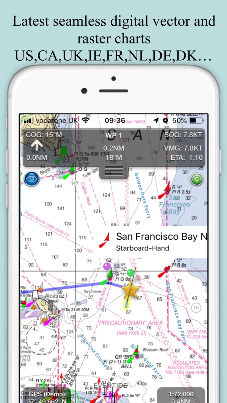
Explore, Plan and Navigate your boating trips in real time and outstanding high-resolution with the latest NOAA Marine charts covering the USA and US Great Lakes.
- Includes all US Coastal, ICW, Inland (USACE) and Great Lakes Digital Vector Charts
- Buoys, lights etc. are tappable with bearing and distance
- Free Apple Watch app
- Live AIS Ship targets and collision alerts (requires Boat Beacon)
- Seamless panning and zooming across charts
- Unique live Augmented Reality camera view
- Route Planning and tracking with Waypoints, ETA, XTE, etc. plus SeaNav autorouting
- Offline charts
- Route export and import to MFDs and other apps via gpx
- ActiveCaptain Marinas, Anchorage, Hazards and reviews
- US NOAA Raster charts available via IAP
- Canadian charts via IAP
- British Virgin Islands & Bermuda charts via IAP
- External NMEA over Wifi
SeaNav uses Digital Vector charts providing a wealth of benefits and advantages. Buoys, Lights, Bridges, Depth Contours, Depth Soundings, Rocks, Anchorage areas, NOAA Weather Buoys etc. are all selectable and have real time distance, bearing and detail information. Turn off layers to de-clutter the display and only show what is important at the time. Tides, moon and sun times and weather are also all available at your fingertips.
SeaNav’s unique AR view mode allows you to view buoys, lights, ships, waypoints and track overlaid on your iPhone or iPad live camera view. With "AR LockOn" you can select a target on the chart and then be guided to it in the AR camera view.
SeaNav lets you measure distances and bearings and record waypoints on routes. When at sea, the app’s Sailing HUD shows your position, Course over ground (COG), Speed over ground (SOG), Vector Made Good (VMG), Estimated Time of Arrival (ETA), Distance and bearing to next Waypoint. Waypoint reached alerts, auto-routing to the next waypoint and collision alerts.
SeaNav comes with a free Apple Watch companion app .
Lowrance, Simrad and B&G GoFree support included.
Your purchase of SeaNav includes 12 months of free updates to the included US chart set. Further chart updates are then available via an in-app purchase. Charts for other regions including Canada may also be added to your product via optional in-app purchase.
Our in-app purchases are 1 year subscriptions, which automatically renew at the end of the subscription period unless auto-renew is turned off at least 24-hours before the end of the current period. Payment will be charged to your iTunes Account at confirmation of purchase, and will be charged for renewal within 24-hours prior to the end of the current period. Pricing for our 1 year US Charts update subscription is US$9.99.
Subscriptions may be managed by the iTunes account holder and auto-renewal may be turned off by going to Account Settings after purchase.
No cancellation of the current subscription is allowed during active subscription period.
Our Privacy Policy may be accessed via http://seanav.net/privacy.php
Requires iPhone or iPad. GPS only required for real time route navigation. Optional Real time AIS, Tides and Weather information require an active internet connection.
iPhone devices and iPads with a cellular modem already have a built-in GPS, even if they do not have an active service plan.
If you have a WiFi-only iPad you will need an external GPS receiver or GPS feed to enable navigation.
Please note that continued use of GPS running in the background can dramatically decrease battery life.
NOT FOR NAVIGATION
This program is distributed in the hope that it will be useful. SeaNav should only be used for basic navigation reference and should not be solely relied upon to determine precise locations, proximity, distance, or direction.
Terms of Use: http://seanav.net/termsofuse.php
Privacy Policy: http://seanav.net/privacy.php
Support: help@pocketmariner.com
Third Party Licenses and Notices
NOTICE: US Marine Charts are derived from official NOAA Electronic Navigational Charts.
In-App Purchases US pricing
Bermuda & British Virgin Island Charts Subscription
Bermuda and BVI Charts · Yearly$12.99
Canada Charts Subscription
Yearly$29.99
NOAA US Raster charts Subscription
Yearly 1-month free trial$9.99
UK Charts Subscription
Yearly$13.99
US Chart Updates Subscription
Yearly$19.99
Weather forecasts Subscription
Weather charts · Yearly$7.49
One-Time Purchases
Man Overboard & Anchor Watch$4.99
Capabilities
In-App Purchases
Accessibility
ipadiphonemacrealityDevicetvoswatch
Version history 25 versions
Build 886207079v5.5.42026-06-01 09:18:56
Satellite view improvements, larger own boat symbol, configurable sog and cog vectors for own boat and other ships.
SeaNav autoroute:
Set start and end point for a route and let SeaNav propose a route and waypoints including the ICW
SeaNav AutoPilot:
Navigate routes automatically. SeaNav can now remotely control Raymarine and Navico/Simrad/Lowrance Auto tillers and helms. You can also use the free SeaNav Apple Watch app to control a Raymarine autohelm and tiller from your wrist.
iOS 26 updates.
Build 880601439v5.5.12026-03-16 09:35:10
SeaNav autoroute:
Set start and end point for a route and let SeaNav propose a route and waypoints including the ICW
SeaNav AutoPilot:
Navigate routes automatically. SeaNav can now remotely control Raymarine and Navico/Simrad/Lowrance Auto tillers and helms. You can also use the free SeaNav Apple Watch app to control a Raymarine autohelm and tiller from your wrist.
iOS 26 updates.
Build 878324669v5.4.202025-09-23 09:10:37
Improved ruler UI :- endpoints now easier to select & drag and magnifier view added to show what's under your finger for more exact placement.
Improvements to offline handling.
Battery level indicator for iPhone landscape mode
Time sensitive alerts for anchor watch and CPA.
Build 875529008v5.4.182025-06-12 10:36:09
Weather forecast overlay with animated Wind, Waves and currents for next 7 days (IAP)
Chart update improvements
Build 873001417v5.4.162025-03-06 13:02:24
Man overboard (MOB) and Anchor Watch features added (IAP).
-Anchor Watch alerts if drifted more than the anchor length or dirfts at more than 1 Knot
-MOB and Anchor buttons on the mainscreen top left (can be turned off in settings)
-MOB distance, bearing and time in water displayed
-MOB takes priority over Anchor Watch
-Anchor Watch also provides an email alert with a map
-SeaNav remains in sailing mode when MOB or Anchor are cleared.
- Check the userguide for more information about using Anchor Watch and Man Overboard
Build 872623505v5.4.152025-02-19 15:35:38
Tide stations and tide currents now available for the US.
Build 871202001v5.4.122024-12-20 10:59:53
UI Improvements
Update for iOS18
Build 866742866v5.4.92024-06-17 09:35:14
UI Improvements and fixes
-Quick Link to Boat Beacon button added (top right) - Boat Beacon also has a quick link back to SeaNav
-Request to launch Boat Beacon on start sailing now defaulted to not show( re-enable in Advanced settings or just use the new Boat Beacon quick link button).
-iPhone landscape mode now also displays current time
-iPad instruments side panel in landscape displays time
-SART TEST targets no longer fire an alarm
-Weather map now scrolls up and down
Build 855897602v5.4.52024-01-10 15:33:37
Fix for updatable charts that have not been updated not displaying if SeaNav is not connected to the internet.
Build 855561782v5.4.22023-03-20 09:59:59
Apple Watch App greatly improved Nav, Waypoint, Map ,CPA Alerts & new real time wind display
My Boat Details now lets you set the type - e.g. Sail, Pleasure, Fishing.
Own boat icon now bigger so more easily viewed and colour shows boat type.
Bridges, Shoreline and Traffic zones UI improvements
Flashing light patterns updated for South Cardinals
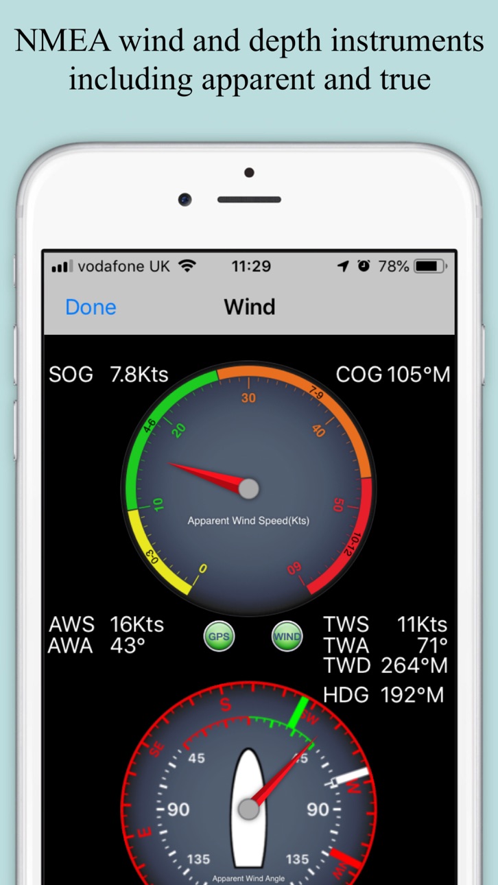
Realtime local wind instrument using SeaNav's Weather feed (IAP) or NMEA over Wifi
Improved Instruments for Nav (inc. Depth), Waypoints & Wind
Export tracks and routes as GPX (e.g to MFDs, Chart plotters and Navionics)
Export and import all POIs
Settings for Auto/Day/Night mode display
Notification sounds fixed
iOS16 ready
Build 848167404v5.42022-04-14 11:02:57
Apple Watch App greatly improved Nav, Waypoint, Map ,CPA Alerts & new real time wind display
Realtime local wind instrument using SeaNav's Weather feed (IAP) or NMEA over Wifi
Improved Instruments for Nav (inc. Depth), Waypoints & Wind
Export tracks and routes as GPX (e.g to MFDs, Chart plotters and Navionics)
Export and import all POIs
Settings for Auto/Day/Night mode display
iOS15 ready
Build 842425826v5.3.32021-06-16 17:02:23
Much faster chart drawing on newer Apple devices ( iPhone 9 and later and iPad 6th gen and later)
Support for iOS Dark mode - better for night time vision and use.
SeaNav iOS and its charts now works on the new MacBook M1.
Cardinal mark light patterns now displayed correctly in light details
Supports full screen width on new iPad Pros
Fix for Apple Watch app sometimes getting stuck
Build 840724297v5.3.12021-03-04 12:20:03
Much faster chart drawing on newer Apple devices ( iPhone 9 and later and iPad 6th gen and later)
Support for iOS Dark mode - better for night time vision and use.
SeaNav iOS and its charts now works on the new MacBook M1.
Cardinal mark light patterns now displayed correctly in light details
Build 831388890v5.12019-05-24 18:42:11
Support for iPhone X full screen - charts now go all the way to the edges.
Detailed animated weather forecast maps including wind, waves & pressure from now up to the 2 weeks ahead based on GFS model as used by NOAA and other leading Met Offices (IAP required).
Simulation mode lets you experience all the features for free.
UI improvements
Build 829104492v4.8.12018-10-31 09:42:58
Fix for SeaNav crashing when SeaNav Watch app is launched
Ship AIS Safety Messages now shown ( ship icon will flash if it is broadcasting a Type 14: Safety-Related Broadcast Message)
Collision detection Time to Collision and Distance collision guards can now be changed from the default of 200m in 10 minutes to any distance and time and can also be disabled by setting CPA Time to 0 - See Boat Details in SeaNav Settings..
POI Manage/Add new POI bug fix.
Fixes for using local AIS over Wifi for own boat location ( AIVDO message - speed and heading now correct)
Build 827620775v4.72018-07-13 09:14:30
Updated Apple Watch app including crown support and adjustable countdown timer.
Fixed Notifications and alerts for iOS and Watch.
Improved search function.
General UI fixes and updates.
GDPR updates
Build 823662594v4.32017-09-18 08:16:59
iOS11 ready.
NMEA Wind, Depth and Boat Speed instruments added.
Build 822854694v4.2.12017-07-12 08:08:22
Fix to re-enable location tracking in background when in Sailing Mode.
Fix for weather information.
4.2 added:-
Favourite Places (POIs):- Add markers for places you want to remember, add a photo and share them with friends too. Add fishing spots with a photo of the one that didn't get away, diving locations, cosy anchorages, hazards, reminders to call in on a VHF channel etc.
Air Draft: See if your boat will fit under a bridge or cable you are approaching in our unique augmented reality view.
Build 822694452v4.22017-06-28 15:48:16
Favourite Places (POIs):- Add markers for places you want to remember, add a photo and share them with friends too. Add fishing spots with a photo of the one that didn't get away, diving locations, cosy anchorages, hazards, reminders to call in on a VHF channel etc.
Air Draft: See if your boat will fit under a bridge or cable you are approaching in our unique augmented reality view.
Ruler for measuring bearings in AR mode when sailing.
Build 822425818v4.12017-06-07 08:52:57
Marine charts for the whole of Spain now available via IAP
Wind instruments added with support for NMEA Wind data via Wi-fi, GoFree and SailTimer ( http://pocketmariner.com/sailtimer ) via Bluetooth. Includes Apparent and True Wind direction and speed readouts. (update for new SailTimer API).
Apple Watch AIS support improvements.
Dropbox™ v2 support for route export and import
Build 819111018v3.8.32016-09-30 15:27:54
Wind instruments added with support for NMEA Wind data via Wi-fi, GoFree and SailTimer ( http://SailTimerWind.com/PocketMariner ) via Bluetooth. Includes Apparent and True Wind direction and speed readouts.(update for new API support).
US Caribbean and Panama Canal Charts now available in US chart set.
Apple Watch GoFree support improvements.
NOAA US Raster Charts IAP option, vector enhanced with tappable buoys/lights etc.
Fix for charts not downloading on iOS10 fresh install.
Build 817928229v3.8.22016-06-30 13:51:10
Wind instruments added with support for NMEA Wind data via Wi-fi, GoFree and SailTimer ( http://SailTimerWind.com/PocketMariner ) via Bluetooth. Includes Apparent and True Wind direction and speed readouts.(update for new API support).
US Caribbean and Panama Canal Charts now available in US chart set.
Apple Watch GoFree support improvements.
NOAA US Raster Charts IAP option, vector enhanced with tappable buoys/lights etc.
Build 817085432v3.82016-06-08 16:37:58
Wind instruments added with support for NMEA Wind data via Wi-fi, GoFree and SailTimer ( http://SailTimerWind.com/PocketMariner ) via Bluetooth. Includes Apparent and True Wind direction and speed readouts.
US Caribbean and Panama Canal Charts now available in US chart set.
Apple Watch GoFree support improvements.
NOAA US Raster Charts IAP option, vector enhanced with tappable buoys/lights etc.
Lock Gates with depths and widths (where available) now show.
Latest spring US Chart updates.
Apple Watch SeaNav app now supports local AIS via Wifi and GoFree.
Build 816748634v3.72016-03-24 23:15:46
NOAA US Raster Charts IAP option, vector enhanced with tappable buoys/lights etc.
Performance improvements
Lock gates now drawn
IALAB buoyage correctly drawn
Build 815116048v3.6.42016-01-05 10:03:43
Improved NMEA support for Wind, Depth and Waypoint information
AIS AtoN buoys and symbols with IALA A and B Buoyage.
Fix for routes not displaying after pressing the eye button.
iOS 9 ready
ActiveCaptain: Marinas, Anchorage, Local Knowledge and Hazards markers and details added. "The best quantity and quality of information available to boaters worldwide". Details on thousands of US and Canadian marinas, anchorages, hazards, local knowledge information, as well as, reviews from other boaters.
Apple Watch support. Check your navigation, waypoints and compass live directly on your Apple Watch from anywhere on your boat.
Navigation, Waypoint, Compass, AIS, Race Timer and Night Mode watch screens provided.
Watch Navigation shows real time SOG,COG,Lat and Long.
Check distance, bearing and time to your next waypoint together with cross track error with a glance at your wrist.
A compass with Course over ground or Heading and bearing to next waypoint. The heading is your true boats heading if your iPhone or iPad is laterally fixed to your boat.
Run a countdown timer to cross the starting line in prime position.
Get AIS alerts to potential collisions and check out the CPA bearing, distance and time to target on the map on your watch.
Price history by region
Currency
Show
Columns
Search
Availability 1 of 1 storefronts
| Region | Language | Price | Ratings | Avg | Version |
|---|---|---|---|---|---|
| US | en-US | USD 19.99 | 98 | 4.3 | 5.5.4 |
Change log 29 changes · US
✎
releaseNotes updated
Satellite view improvements, larger own boat symbol, configurable sog and cog vectors for own boat and other ships.
SeaNav autoroute:
Set start and end point
✎
description updated
Explore, Plan and Navigate your boating trips in real time and outstanding high-resolution with the latest NOAA Marine charts covering the USA and US Great Lake
✎
subtitle updated
HD Marine Navigation & Charts
✎
name updated
SeaNav US
◆
Version 5.5.4 released
Satellite view improvements, larger own boat symbol, configurable sog and cog vectors for own boat and other ships.
SeaNav autoroute:
Set start and end point for a route and let SeaNav propose a route and waypoints including the ICW
Sea
◆
Version 5.5.1 released
SeaNav autoroute:
Set start and end point for a route and let SeaNav propose a route and waypoints including the ICW
SeaNav AutoPilot:
Navigate routes automatically. SeaNav can now remotely control Raymarine and Navico/Simrad/Lowrance A
◆
Version 5.4.20 released
Improved ruler UI :- endpoints now easier to select & drag and magnifier view added to show what's under your finger for more exact placement.
Improvements to offline handling.
Battery level indicator for iPhone landscape mode
Time sensitiv
◆
Version 5.4.18 released
Weather forecast overlay with animated Wind, Waves and currents for next 7 days (IAP)
Chart update improvements
◆
Version 5.4.16 released
Man overboard (MOB) and Anchor Watch features added (IAP).
-Anchor Watch alerts if drifted more than the anchor length or dirfts at more than 1 Knot
-MOB and Anchor buttons on the mainscreen top left (can be turned off in settings)
-MOB d
◆
Version 5.4.15 released
Tide stations and tide currents now available for the US.
◆
Version 5.4.12 released
UI Improvements
Update for iOS18
◆
Version 5.4.9 released
UI Improvements and fixes
-Quick Link to Boat Beacon button added (top right) - Boat Beacon also has a quick link back to SeaNav
-Request to launch Boat Beacon on start sailing now defaulted to not show( re-enable in Advanced settings or j
◆
Version 5.4.5 released
Fix for updatable charts that have not been updated not displaying if SeaNav is not connected to the internet.
◆
Version 5.4.2 released
Apple Watch App greatly improved Nav, Waypoint, Map ,CPA Alerts & new real time wind display
My Boat Details now lets you set the type - e.g. Sail, Pleasure, Fishing.
Own boat icon now bigger so more easily viewed and colour shows boat typ
◆
Version 5.4 released
Apple Watch App greatly improved Nav, Waypoint, Map ,CPA Alerts & new real time wind display
Realtime local wind instrument using SeaNav's Weather feed (IAP) or NMEA over Wifi
Improved Instruments for Nav (inc. Depth), Waypoints & Wind
Expo
◆
Version 5.3.3 released
Much faster chart drawing on newer Apple devices ( iPhone 9 and later and iPad 6th gen and later)
Support for iOS Dark mode - better for night time vision and use.
SeaNav iOS and its charts now works on the new MacBook M1.
Cardinal mark
◆
Version 5.3.1 released
Much faster chart drawing on newer Apple devices ( iPhone 9 and later and iPad 6th gen and later)
Support for iOS Dark mode - better for night time vision and use.
SeaNav iOS and its charts now works on the new MacBook M1.
Cardinal mark
◆
Version 5.1 released
Support for iPhone X full screen - charts now go all the way to the edges.
Detailed animated weather forecast maps including wind, waves & pressure from now up to the 2 weeks ahead based on GFS model as used by NOAA and other leading Met Of
◆
Version 4.8.1 released
Fix for SeaNav crashing when SeaNav Watch app is launched
Ship AIS Safety Messages now shown ( ship icon will flash if it is broadcasting a Type 14: Safety-Related Broadcast Message)
Collision detection Time to Collision and Distance collis
◆
Version 4.7 released
Updated Apple Watch app including crown support and adjustable countdown timer.
Fixed Notifications and alerts for iOS and Watch.
Improved search function.
General UI fixes and updates.
GDPR updates
◆
Version 4.3 released
iOS11 ready.
NMEA Wind, Depth and Boat Speed instruments added.
◆
Version 4.2.1 released
Fix to re-enable location tracking in background when in Sailing Mode.
Fix for weather information.
4.2 added:-
Favourite Places (POIs):- Add markers for places you want to remember, add a photo and share them with friends too. Add fishin
◆
Version 4.2 released
Favourite Places (POIs):- Add markers for places you want to remember, add a photo and share them with friends too. Add fishing spots with a photo of the one that didn't get away, diving locations, cosy anchorages, hazards, reminders to cal
◆
Version 4.1 released
Marine charts for the whole of Spain now available via IAP
Wind instruments added with support for NMEA Wind data via Wi-fi, GoFree and SailTimer ( http://pocketmariner.com/sailtimer ) via Bluetooth. Includes Apparent and True Wind directio
◆
Version 3.8.3 released
Wind instruments added with support for NMEA Wind data via Wi-fi, GoFree and SailTimer ( http://SailTimerWind.com/PocketMariner ) via Bluetooth. Includes Apparent and True Wind direction and speed readouts.(update for new API support).
US C
◆
Version 3.8.2 released
Wind instruments added with support for NMEA Wind data via Wi-fi, GoFree and SailTimer ( http://SailTimerWind.com/PocketMariner ) via Bluetooth. Includes Apparent and True Wind direction and speed readouts.(update for new API support).
US C
◆
Version 3.8 released
Wind instruments added with support for NMEA Wind data via Wi-fi, GoFree and SailTimer ( http://SailTimerWind.com/PocketMariner ) via Bluetooth. Includes Apparent and True Wind direction and speed readouts.
US Caribbean and Panama Canal Cha
◆
Version 3.7 released
NOAA US Raster Charts IAP option, vector enhanced with tappable buoys/lights etc.
Performance improvements
Lock gates now drawn
IALAB buoyage correctly drawn
◆
Version 3.6.4 released
Improved NMEA support for Wind, Depth and Waypoint information
AIS AtoN buoys and symbols with IALA A and B Buoyage.
Fix for routes not displaying after pressing the eye button.
iOS 9 ready
ActiveCaptain: Marinas, Anchorage, Local Knowl