Home › Navigation

 BB
BB
 USen-US
 CAen-CA
 CZen-GB
 DEde-DE
 GBen-GB
 NOen-GB
 SKen-GB
 TWzh-Hant-TW
 AEen-GB
 AFen-GB
 AGen-GB
 AIen-GB
 ALen-GB
 AMen-GB
 AOen-GB
 ARes-MX
 ATde-DE
 AUen-AU
 AZen-GB
 BAen-GBBBen-GB
 BEen-GB
 BFen-GB
 BGen-GB
 BHen-GB
 BJen-GB
 BMen-GB
 BNen-GB
 BRpt-BR
 BSen-GB
 BTen-GB
 BWen-GB
 BYen-GB
 BZen-GB
 CDen-GB
 CGen-GB
 CHde-CH
 CIfr-FR
 CLes-MX
 CMfr-FR
 CNzh-Hans-CN
 COes-MX
 CVen-GB
 CYen-GB
 DKen-GB
 DMen-GB
 DZen-GB
 ECes-MX
 EEen-GB
 ESes-ES
 FIen-GB
 FJen-GB
 FMen-GB
 FRfr-FR
 GAfr-FR
 GDen-GB
 GEen-GB
 GHen-GB
 GMen-GB
 GRen-GB
 GTes-MX
 GWen-GB
 GYen-GB
 HKzh-Hant-HK
 HNes-MX
 HRen-GB
 HUen-GB
 IDen-GB
 IEen-GB
 ILen-GB
 INen-GB
 ISen-GB
 ITit
ITit JMen-GB
 JOen-GB
 JPja
JPja KEen-GB
 KGen-GB
 KHen-GB
 KNen-GB
 KRko
KRko KWen-GB
 KYen-GB
 KZen-GB
 LAen-GB
 LBen-GB
 LCen-GB
 LKen-GB
 LRen-GB
 LTen-GB
 LUen-GB
 LVen-GB
 LYen-GB
 MAen-GB
 MDen-GB
 MEen-GB
 MGen-GB
 MKen-GB
 MLen-GB
 MMen-GB
 MNen-GB
 MOzh-Hant-HK
 MRen-GB
 MSen-GB
 MTen-GB
 MUen-GB
 MVen-GB
 MWen-GB
 MXes-MX
 MYen-GB
 MZen-GB
 NAen-GB
 NEen-GB
 NGen-GB
 NIes-MX
 NLnl
NLnl NPen-GB
 NRen-GB
 NZen-AU
 OMen-GB
 PAes-MX
 PEes-MX
 PGen-GB
 PHen-GB
 PKen-GB
 PLen-GB
 PTpt-PT
 PWen-GB
 QAen-GB
 ROen-GB
 RSen-GB
 RUru
RUru RWen-GB
 SAen-GB
 SBen-GB
 SCen-GB
 SEsv
SEsv SGen-GB
 SIen-GB
 SLen-GB
 SNen-GB
 SRen-GB
 STen-GB
 SZen-GB
 TCen-GB
 TDen-GB
 THen-GB
 TJen-GB
 TMen-GB
 TNen-GB
 TOen-GB
 TRen-GB
 TTen-GB
 TZen-GB
 UAen-GB
 UGen-GB
 UZen-GB
 VCen-GB
 VEes-MX
 VGen-GB
 VNen-GB
 VUen-GB
 XKen-GB
 YEen-GB
 ZAen-GB
 ZMen-GB
 ZWen-GB
167 of 167 storefronts
Content in en-US
Content in en-US
Information
Apple ID1527565210
Bundle IDcz.dronetag.app
SellerSeller
Min iOS16.0
Min macOS13.0
Device familiesiphone, ipad
Released2021-08-28
Copyright© 2026 Dronetag s.r.o
Privacy policyLink ↗
Preview 2 platforms
iPhone 4 images


iPad 3 images


What’s New Version 2.240.0
This release brings a new functionality: You can add your custom colors & labels to detected drones. The color & label then show up on detection cards, the detection table, detail panels, and even live on the dashboard map overlay. No more squinting to tell aircraft apart.
Thanks for flying with Dronetag.
Description
Dronetag brings an all-in-one solution for safe drone flights that allows you to comply with the new European regulations, manage your fleet and stay informed about your current flights. Our vision is to provide drones with safe access to the airspace and to prevent their accidents.
We manufacture a hardware device Dronetag Mini designed as an add-on that can be mounted to any drone. Mini ensures that your drone is visible for all air traffic participants. It is no larger than half of your favorite müsli bar, weighs 30 grams, and stays charged for up to 8 hours. The device may be combined with our app to unlock new possibilities for your flights.
The combination of the Dronetag Mini device and app offers the following:
- Local and network remote identification in compliance with the European regulations.
- Add and manage an unlimited number of unmanned aircraft.
- View restricted zones such as airports within the whole EU.
- Plan your flight, including the time and altitude.
- Track your current flight on the map and receive notifications.
- Keep and export a flight journal for all your drones.
- See other airspace participants with Dronetag devices installed.
- Search full-text: Locations, restricted zones, aircraft, and Dronetag devices.
Accessibility
ipadiphonemacrealityDevicetvoswatch
Version history 25 versions
Build 886831445v2.240.02026-06-11 20:34:02
This release brings a new functionality: You can add your custom colors & labels to detected drones. The color & label then show up on detection cards, the detection table, detail panels, and even live on the dashboard map overlay. No more squinting to tell aircraft apart.
Thanks for flying with Dronetag.
Build 885380016v2.235.22026-05-20 20:01:37
This update adds the ability to filter air traffic by type and technology (you can now hide ADS-B traffic to focus only on what's relevant to you). Users migrating from the previous notifications and local Alerts setup will find new tools to help transition smoothly to the current notification system. This release also includes minor bug fixes and removes an outdated zones map layer.
Build 884984130v2.228.02026-04-28 01:50:39
We have resolved a reported issue that occasionally prevented the complete loading of the information panel for real-time detection.
Build 884594753v2.227.12026-04-20 22:28:00
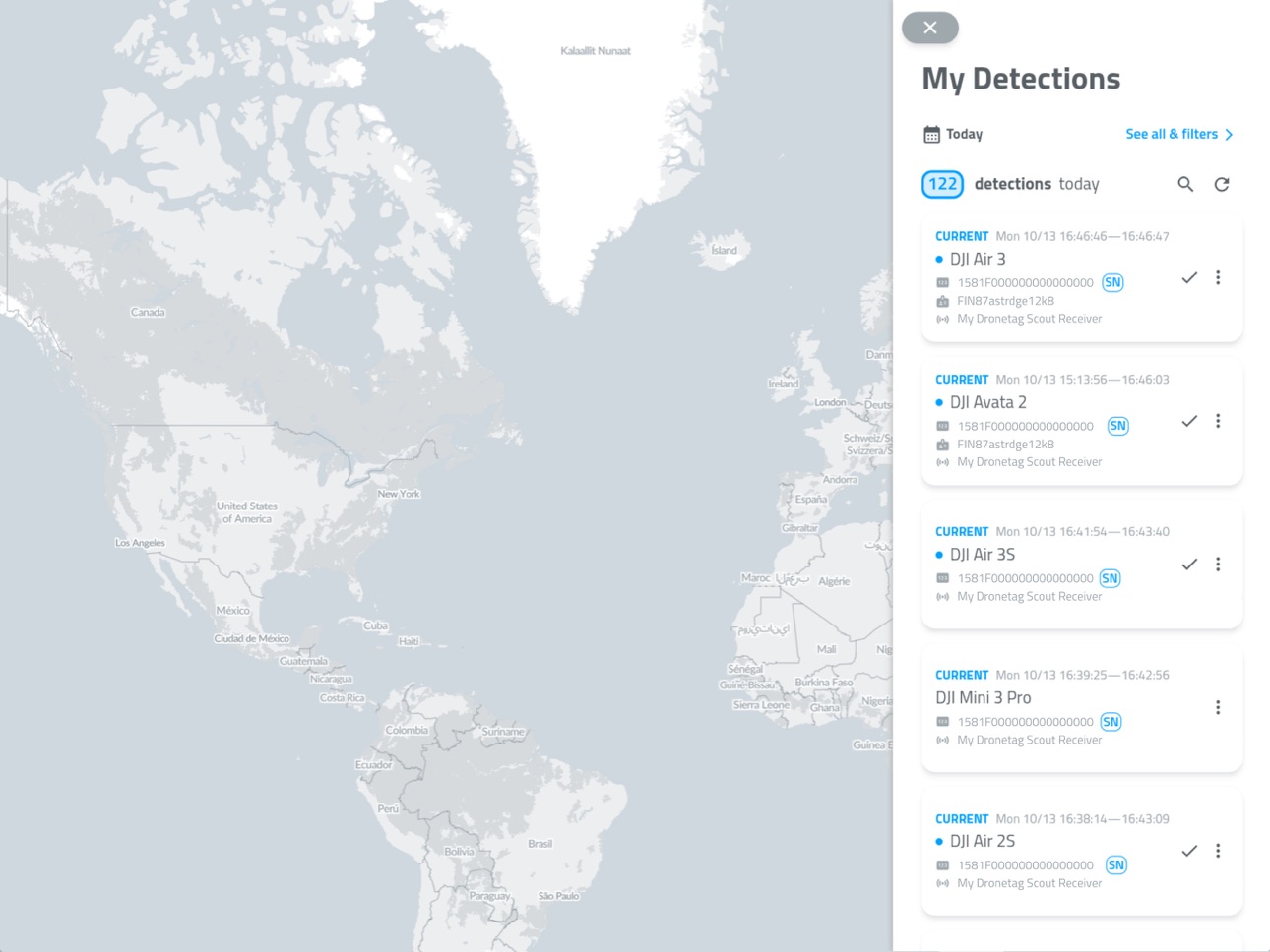
We have released a 'Map view' – a new view type available in detections screen
Build 884502892v2.227.02026-04-14 19:13:40
New notifications are leaving early access and are now publicly available to all users – the new system adds support for Dronetag RIDER and Scout, introduces geozones, ignore lists for specific drones, and new alert types.
Build 883714358v2.218.02026-03-25 14:36:33
This update expands the notifications early access with new options to define monitoring regions and ignore specific UAS IDs. Push notifications now play sound and show visual effects, matching the behavior of real-time Alerts. First-time installs will also find the map automatically centered on their local area.
Build 882915174v2.212.02026-03-01 22:38:45
This update brings early access to the new notification system for a selected group of customers and introduces several quality-of-life improvements, including refinements to notification settings.
We’ve also made small UI tweaks for faster access — “Mark all as seen” and export actions were moved to the detections overview bar. Sharing is now clearer, with the sender’s e-mail shown on shared detection badges and tooltips. Finally, sign-in errors are easier to understand when authentication fails.
Build 882110495v2.203.12026-02-03 21:03:42
Map layers (such as FAA UAS Facility Maps) are now enabled by default for all users.
This version also fixes various issues with detection filtering, accessing your map pins, and more.
Build 881289717v2.198.12026-01-13 00:22:15
Improved offline flight synchronization flow and its reliability. Fixed handling of imperial altitude units across different parts of the application. Flight export processing should now be more reliable and less memory consuming. Added support for Remote ID identification setup in the United Kingdom.
Build 880242970v2.188.22025-12-01 20:26:09
Improved map reliability, aircraft and telemetry accuracy, added clearer connection and alert controls, and fixed several crashes and UI inconsistencies for a smoother overall experience.
Build 878896816v2.180.52025-10-14 18:07:01
New map layers available in map settings – altitude grids in US (FAA) and CZ (ANS) are now available both on the real-time map and in detection details. Map reloading has been improved, plus multiple minor features and bugfixes included too.
Build 878590193v2.176.02025-10-02 04:31:13
The latest update introduces powerful new features: set up custom alert zones for local detection, refine your detections with advanced filters and drone model search, and share receiver positions independent of cloud visibility settings. We’ve also enhanced map support of altitude units.
Build 878329568v2.167.32025-09-22 23:41:14
We're bringing another update of our app with a few new features – we have slightly improved filtering and searching on the My Detections Screen. You can now see devices which were shared with you, and share devices with others, using the new feature on device detail screen. When multiple receivers are used to detect single aircraft, you will now see all receivers positions on detection detail when browsing history. Lastly, few bugs here and there were fixed.
Build 878070583v2.161.62025-09-14 09:48:41
We're bringing another update, consisting mostly of minor bug fixes, and with one small feature – it is now possible to share devices with other users, see "Share data with others" option on device detail screen
Build 877169352v2.155.112025-08-12 03:27:43
This update brings a completely redesigned detection detail view, new options to mark and hide seen detections, better performance and reliability on poor connections, fixes for DRI scanning on certain devices, new configuration and firmware support for Dronetag RIDER, a basic geographic radius setting for real-time alerts, vastly improved detection list performance for heavy users, and numerous minor bug fixes.
Build 876521162v2.149.12025-07-19 18:06:56
The historical data browsing mode has been restored to the map, enabling users to access information from previous days. Additionally, the export functionality has been freed from its previous limitations. Minor issues, such as occasional duplication of aircraft selections upon tapping the map, have also been rectified.
Build 876157706v2.148.22025-07-07 17:38:53
In our new app version you can assign your Dronetag devices new color tags and callsigns.
Build 875815987v2.147.02025-06-23 22:08:56
We have released a minor app update to fix a few minor bugs.
Build 875600368v2.145.12025-06-15 23:13:13
This update introduces an experimental new feature: real-time alerts. On the Detections screen, you can now export a full day's worth of detections for a single receiver. And as always, this update also includes minor performance improvements and bug fixes.
Build 875420922v2.143.02025-06-09 06:34:06
We're bringing another update with new features and bugfixes – minor changes and fixes to our map, added support for new UA identifier types, operation details now show more detailed information.
Build 874448669v2.138.12025-05-01 16:27:13
We’ve fixed several crashes that occurred when scanning drones. You can now monitor the status of Dronetag Scout devices directly in the app. Additionally, Dronetag RIDER devices can now be configured to filter detections via a new settings screen.
Build 874027167v2.136.02025-04-15 13:57:18
We have fixed a few minor issues — mostly related to the map on the dashboard and the flight detail screen.
Build 873813341v2.134.02025-04-06 22:13:26
For user accounts using callsigns and color tags, we now display them in device list too.
Build 873786489v2.132.02025-04-04 21:47:11
We've improved the performance and functionality of our map. You can now view the real-time positions of your receivers, select multiple altitudes to display, and benefit from several smaller fixes and enhancements.
Build 873526310v2.130.22025-03-25 19:19:54
We have added the ability to enable DRI traffic scanned by your phone on the new Global Map. This feature is opt-in and can be enabled in the map settings. We have also fixed issues causing stuttering during scrolling on the timeline in the flight/detail detection view. The operator's position is now displayed on the map even if it falls outside the selected time range. Various minor fixes and improvements have been made, improving navigation, and enhancing the flight player timeline scrolling.
No pricing data captured yet — comparisons appear once the app has paid storefronts or in-app purchases.
Availability 167 of 167 storefronts
| Region | Language | Price | Ratings | Avg | Version |
|---|---|---|---|---|---|
| US | en-US | Free | 8 | 2.9 | 2.240.0 |
| CA | en-CA | Free | 2 | 1.0 | 2.240.0 |
| CZ | en-GB | Free | 2 | 5.0 | 2.240.0 |
| DE | de-DE | Free | 1 | 1.0 | 2.240.0 |
| GB | en-GB | Free | 1 | 5.0 | 2.240.0 |
| NO | en-GB | Free | 1 | 5.0 | 2.240.0 |
| SK | en-GB | Free | 1 | 5.0 | 2.240.0 |
| TW | zh-Hant-TW | Free | 1 | 5.0 | 2.240.0 |
| AE | en-GB | Free | 0 | — | 2.240.0 |
| AF | en-GB | Free | 0 | — | 2.240.0 |
| AG | en-GB | Free | 0 | — | 2.240.0 |
| AI | en-GB | Free | 0 | — | 2.240.0 |
| AL | en-GB | Free | 0 | — | 2.240.0 |
| AM | en-GB | Free | 0 | — | 2.240.0 |
| AO | en-GB | Free | 0 | — | 2.240.0 |
| AR | es-MX | Free | 0 | — | 2.240.0 |
| AT | de-DE | Free | 0 | — | 2.240.0 |
| AU | en-AU | Free | 0 | — | 2.240.0 |
| AZ | en-GB | Free | 0 | — | 2.240.0 |
| BA | en-GB | Free | 0 | — | 2.240.0 |
| BB | en-GB | Free | 0 | — | 2.240.0 |
| BE | en-GB | Free | 0 | — | 2.240.0 |
| BF | en-GB | Free | 0 | — | 2.240.0 |
| BG | en-GB | Free | 0 | — | 2.240.0 |
| BH | en-GB | Free | 0 | — | 2.240.0 |
| BJ | en-GB | Free | 0 | — | 2.240.0 |
| BM | en-GB | Free | 0 | — | 2.240.0 |
| BN | en-GB | Free | 0 | — | 2.240.0 |
| BR | pt-BR | Free | 0 | — | 2.240.0 |
| BS | en-GB | Free | 0 | — | 2.240.0 |
| BT | en-GB | Free | 0 | — | 2.240.0 |
| BW | en-GB | Free | 0 | — | 2.240.0 |
| BY | en-GB | Free | 0 | — | 2.240.0 |
| BZ | en-GB | Free | 0 | — | 2.240.0 |
| CD | en-GB | Free | 0 | — | 2.240.0 |
| CG | en-GB | Free | 0 | — | 2.240.0 |
| CH | de-CH | Free | 0 | — | 2.240.0 |
| CI | fr-FR | Free | 0 | — | 2.240.0 |
| CL | es-MX | Free | 0 | — | 2.240.0 |
| CM | fr-FR | Free | 0 | — | 2.240.0 |
| CN | zh-Hans-CN | Free | 0 | — | 2.240.0 |
| CO | es-MX | Free | 0 | — | 2.240.0 |
| CV | en-GB | Free | 0 | — | 2.240.0 |
| CY | en-GB | Free | 0 | — | 2.240.0 |
| DK | en-GB | Free | 0 | — | 2.240.0 |
| DM | en-GB | Free | 0 | — | 2.240.0 |
| DZ | en-GB | Free | 0 | — | 2.240.0 |
| EC | es-MX | Free | 0 | — | 2.240.0 |
| EE | en-GB | Free | 0 | — | 2.240.0 |
| ES | es-ES | Free | 0 | — | 2.240.0 |
| FI | en-GB | Free | 0 | — | 2.240.0 |
| FJ | en-GB | Free | 0 | — | 2.240.0 |
| FM | en-GB | Free | 0 | — | 2.240.0 |
| FR | fr-FR | Free | 0 | — | 2.240.0 |
| GA | fr-FR | Free | 0 | — | 2.240.0 |
| GD | en-GB | Free | 0 | — | 2.240.0 |
| GE | en-GB | Free | 0 | — | 2.240.0 |
| GH | en-GB | Free | 0 | — | 2.240.0 |
| GM | en-GB | Free | 0 | — | 2.240.0 |
| GR | en-GB | Free | 0 | — | 2.240.0 |
| GT | es-MX | Free | 0 | — | 2.240.0 |
| GW | en-GB | Free | 0 | — | 2.240.0 |
| GY | en-GB | Free | 0 | — | 2.240.0 |
| HK | zh-Hant-HK | Free | 0 | — | 2.240.0 |
| HN | es-MX | Free | 0 | — | 2.240.0 |
| HR | en-GB | Free | 0 | — | 2.240.0 |
| HU | en-GB | Free | 0 | — | 2.240.0 |
| ID | en-GB | Free | 0 | — | 2.240.0 |
| IE | en-GB | Free | 0 | — | 2.240.0 |
| IL | en-GB | Free | 0 | — | 2.240.0 |
| IN | en-GB | Free | 0 | — | 2.240.0 |
| IS | en-GB | Free | 0 | — | 2.240.0 |
| IT | it | Free | 0 | — | 2.240.0 |
| JM | en-GB | Free | 0 | — | 2.240.0 |
| JO | en-GB | Free | 0 | — | 2.240.0 |
| JP | ja | Free | 0 | — | 2.240.0 |
| KE | en-GB | Free | 0 | — | 2.240.0 |
| KG | en-GB | Free | 0 | — | 2.240.0 |
| KH | en-GB | Free | 0 | — | 2.240.0 |
| KN | en-GB | Free | 0 | — | 2.240.0 |
| KR | ko | Free | 0 | — | 2.240.0 |
| KW | en-GB | Free | 0 | — | 2.240.0 |
| KY | en-GB | Free | 0 | — | 2.240.0 |
| KZ | en-GB | Free | 0 | — | 2.240.0 |
| LA | en-GB | Free | 0 | — | 2.240.0 |
| LB | en-GB | Free | 0 | — | 2.240.0 |
| LC | en-GB | Free | 0 | — | 2.240.0 |
| LK | en-GB | Free | 0 | — | 2.240.0 |
| LR | en-GB | Free | 0 | — | 2.240.0 |
| LT | en-GB | Free | 0 | — | 2.240.0 |
| LU | en-GB | Free | 0 | — | 2.240.0 |
| LV | en-GB | Free | 0 | — | 2.240.0 |
| LY | en-GB | Free | 0 | — | 2.240.0 |
| MA | en-GB | Free | 0 | — | 2.240.0 |
| MD | en-GB | Free | 0 | — | 2.240.0 |
| ME | en-GB | Free | 0 | — | 2.240.0 |
| MG | en-GB | Free | 0 | — | 2.240.0 |
| MK | en-GB | Free | 0 | — | 2.240.0 |
| ML | en-GB | Free | 0 | — | 2.240.0 |
| MM | en-GB | Free | 0 | — | 2.240.0 |
| MN | en-GB | Free | 0 | — | 2.240.0 |
| MO | zh-Hant-HK | Free | 0 | — | 2.240.0 |
| MR | en-GB | Free | 0 | — | 2.240.0 |
| MS | en-GB | Free | 0 | — | 2.240.0 |
| MT | en-GB | Free | 0 | — | 2.240.0 |
| MU | en-GB | Free | 0 | — | 2.240.0 |
| MV | en-GB | Free | 0 | — | 2.240.0 |
| MW | en-GB | Free | 0 | — | 2.240.0 |
| MX | es-MX | Free | 0 | — | 2.240.0 |
| MY | en-GB | Free | 0 | — | 2.240.0 |
| MZ | en-GB | Free | 0 | — | 2.240.0 |
| NA | en-GB | Free | 0 | — | 2.240.0 |
| NE | en-GB | Free | 0 | — | 2.240.0 |
| NG | en-GB | Free | 0 | — | 2.240.0 |
| NI | es-MX | Free | 0 | — | 2.240.0 |
| NL | nl | Free | 0 | — | 2.240.0 |
| NP | en-GB | Free | 0 | — | 2.240.0 |
| NR | en-GB | Free | 0 | — | 2.240.0 |
| NZ | en-AU | Free | 0 | — | 2.240.0 |
| OM | en-GB | Free | 0 | — | 2.240.0 |
| PA | es-MX | Free | 0 | — | 2.240.0 |
| PE | es-MX | Free | 0 | — | 2.240.0 |
| PG | en-GB | Free | 0 | — | 2.240.0 |
| PH | en-GB | Free | 0 | — | 2.240.0 |
| PK | en-GB | Free | 0 | — | 2.240.0 |
| PL | en-GB | Free | 0 | — | 2.240.0 |
| PT | pt-PT | Free | 0 | — | 2.240.0 |
| PW | en-GB | Free | 0 | — | 2.240.0 |
| QA | en-GB | Free | 0 | — | 2.240.0 |
| RO | en-GB | Free | 0 | — | 2.240.0 |
| RS | en-GB | Free | 0 | — | 2.240.0 |
| RU | ru | Free | 0 | — | 2.240.0 |
| RW | en-GB | Free | 0 | — | 2.240.0 |
| SA | en-GB | Free | 0 | — | 2.240.0 |
| SB | en-GB | Free | 0 | — | 2.240.0 |
| SC | en-GB | Free | 0 | — | 2.240.0 |
| SE | sv | Free | 0 | — | 2.240.0 |
| SG | en-GB | Free | 0 | — | 2.240.0 |
| SI | en-GB | Free | 0 | — | 2.240.0 |
| SL | en-GB | Free | 0 | — | 2.240.0 |
| SN | en-GB | Free | 0 | — | 2.240.0 |
| SR | en-GB | Free | 0 | — | 2.240.0 |
| ST | en-GB | Free | 0 | — | 2.240.0 |
| SZ | en-GB | Free | 0 | — | 2.240.0 |
| TC | en-GB | Free | 0 | — | 2.240.0 |
| TD | en-GB | Free | 0 | — | 2.240.0 |
| TH | en-GB | Free | 0 | — | 2.240.0 |
| TJ | en-GB | Free | 0 | — | 2.240.0 |
| TM | en-GB | Free | 0 | — | 2.240.0 |
| TN | en-GB | Free | 0 | — | 2.240.0 |
| TO | en-GB | Free | 0 | — | 2.240.0 |
| TR | en-GB | Free | 0 | — | 2.240.0 |
| TT | en-GB | Free | 0 | — | 2.240.0 |
| TZ | en-GB | Free | 0 | — | 2.240.0 |
| UA | en-GB | Free | 0 | — | 2.240.0 |
| UG | en-GB | Free | 0 | — | 2.240.0 |
| UZ | en-GB | Free | 0 | — | 2.240.0 |
| VC | en-GB | Free | 0 | — | 2.240.0 |
| VE | es-MX | Free | 0 | — | 2.240.0 |
| VG | en-GB | Free | 0 | — | 2.240.0 |
| VN | en-GB | Free | 0 | — | 2.240.0 |
| VU | en-GB | Free | 0 | — | 2.240.0 |
| XK | en-GB | Free | 0 | — | 2.240.0 |
| YE | en-GB | Free | 0 | — | 2.240.0 |
| ZA | en-GB | Free | 0 | — | 2.240.0 |
| ZM | en-GB | Free | 0 | — | 2.240.0 |
| ZW | en-GB | Free | 0 | — | 2.240.0 |
Change log 28 changes · BB
✎
releaseNotes updated
This release brings a new functionality: You can add your custom colors & labels to detected drones. The color & label then show up on detection cards, the dete
✎
description updated
Dronetag brings an all-in-one solution for safe drone flights that allows you to comply with the new European regulations, manage your fleet and stay informed a
✎
name updated
Dronetag
◆
Version 2.240.0 released
This release brings a new functionality: You can add your custom colors & labels to detected drones. The color & label then show up on detection cards, the detection table, detail panels, and even live on the dashboard map overlay. No more
◆
Version 2.235.2 released
This update adds the ability to filter air traffic by type and technology (you can now hide ADS-B traffic to focus only on what's relevant to you). Users migrating from the previous notifications and local Alerts setup will find new tools t
◆
Version 2.228.0 released
We have resolved a reported issue that occasionally prevented the complete loading of the information panel for real-time detection.
◆
Version 2.227.1 released
We have released a 'Map view' – a new view type available in detections screen
◆
Version 2.227.0 released
New notifications are leaving early access and are now publicly available to all users – the new system adds support for Dronetag RIDER and Scout, introduces geozones, ignore lists for specific drones, and new alert types.
◆
Version 2.218.0 released
This update expands the notifications early access with new options to define monitoring regions and ignore specific UAS IDs. Push notifications now play sound and show visual effects, matching the behavior of real-time Alerts. First-time i
◆
Version 2.212.0 released
This update brings early access to the new notification system for a selected group of customers and introduces several quality-of-life improvements, including refinements to notification settings.
We’ve also made small UI tweaks for faste
◆
Version 2.203.1 released
Map layers (such as FAA UAS Facility Maps) are now enabled by default for all users.
This version also fixes various issues with detection filtering, accessing your map pins, and more.
◆
Version 2.198.1 released
Improved offline flight synchronization flow and its reliability. Fixed handling of imperial altitude units across different parts of the application. Flight export processing should now be more reliable and less memory consuming. Added sup
◆
Version 2.188.2 released
Improved map reliability, aircraft and telemetry accuracy, added clearer connection and alert controls, and fixed several crashes and UI inconsistencies for a smoother overall experience.
◆
Version 2.180.5 released
New map layers available in map settings – altitude grids in US (FAA) and CZ (ANS) are now available both on the real-time map and in detection details. Map reloading has been improved, plus multiple minor features and bugfixes included too
◆
Version 2.176.0 released
The latest update introduces powerful new features: set up custom alert zones for local detection, refine your detections with advanced filters and drone model search, and share receiver positions independent of cloud visibility settings. W
◆
Version 2.167.3 released
We're bringing another update of our app with a few new features – we have slightly improved filtering and searching on the My Detections Screen. You can now see devices which were shared with you, and share devices with others, using the n
◆
Version 2.161.6 released
We're bringing another update, consisting mostly of minor bug fixes, and with one small feature – it is now possible to share devices with other users, see "Share data with others" option on device detail screen
◆
Version 2.155.11 released
This update brings a completely redesigned detection detail view, new options to mark and hide seen detections, better performance and reliability on poor connections, fixes for DRI scanning on certain devices, new configuration and firmwar
◆
Version 2.149.1 released
The historical data browsing mode has been restored to the map, enabling users to access information from previous days. Additionally, the export functionality has been freed from its previous limitations. Minor issues, such as occasional d
◆
Version 2.148.2 released
In our new app version you can assign your Dronetag devices new color tags and callsigns.
◆
Version 2.147.0 released
We have released a minor app update to fix a few minor bugs.
◆
Version 2.145.1 released
This update introduces an experimental new feature: real-time alerts. On the Detections screen, you can now export a full day's worth of detections for a single receiver. And as always, this update also includes minor performance improvemen
◆
Version 2.143.0 released
We're bringing another update with new features and bugfixes – minor changes and fixes to our map, added support for new UA identifier types, operation details now show more detailed information.
◆
Version 2.138.1 released
We’ve fixed several crashes that occurred when scanning drones. You can now monitor the status of Dronetag Scout devices directly in the app. Additionally, Dronetag RIDER devices can now be configured to filter detections via a new settings
◆
Version 2.136.0 released
We have fixed a few minor issues — mostly related to the map on the dashboard and the flight detail screen.
◆
Version 2.134.0 released
For user accounts using callsigns and color tags, we now display them in device list too.
◆
Version 2.132.0 released
We've improved the performance and functionality of our map. You can now view the real-time positions of your receivers, select multiple altitudes to display, and benefit from several smaller fixes and enhancements.
◆
Version 2.130.2 released
We have added the ability to enable DRI traffic scanned by your phone on the new Global Map. This feature is opt-in and can be enabled in the map settings. We have also fixed issues causing stuttering during scrolling on the timeline in the