Home › Utilities

 EE
EE
 USen-US
 INen-GB
 KHen-GB
 ARes-MX
 THen-GB
 RUru
RUru UAen-GB
 ROen-GB
 KZen-GB
 VNen-GB
 ITit
ITit UZen-GB
 GBen-GB
 NZen-AU
 AUen-AU
 IDen-GB
 ESes-ES
 CAen-CA
 PTpt-PT
 PYes-MX
 FRfr-FR
 ZAen-GB
 DEde-DE
 IEen-GB
 KGen-GB
 TRen-GB
 LKen-GB
 DOes-MX
 AZen-GB
 PKen-GB
 BGen-GB
 GRen-GB
 PHen-GB
 HUen-GB
 CRes-MX
 MYen-GB
 MMen-GB
 AMen-GB
 BOes-MX
 SGen-GB
 KRko
KRko ECes-MX
 ALen-GB
 SAen-GB
 PLen-GB
 MDen-GB
 NLnl
NLnl TWzh-Hant-TW
 VEes-MX
 EGen-GB
 PAes-MX
 LTen-GB
 BYen-GB
 IQen-GB
 BEen-GB
 AEen-GB
 HRen-GB
 ILen-GB
 TJen-GB
 JPja
JPja RSen-GB
 SNen-GB
 GEen-GB
 LVen-GB
 CHde-CH
 MNen-GB
 XKen-GB
 AOen-GB
 CNzh-Hans-CN
 LAen-GB
 DKen-GB
 CZen-GB
 TNen-GB
 SEsv
SEsv ATde-DE
 SKen-GB
 TMen-GB
 CYen-GB
 SIen-GB
 NPen-GB
 QAen-GB
 AFen-GB
 MKen-GB
 YEen-GB
 BAen-GB
 MRen-GB
 JOen-GB
 LBen-GB
 OMen-GB
 PWen-GB
 NOen-GB
 FIen-GB
 KWen-GB
 HKzh-Hant-HK
 BTen-GB
 FJen-GBEEen-GB
 LUen-GB
 BHen-GB
 MEen-GB
 BNen-GB
 ISen-GB
 PGen-GB
 TOen-GB
 MTen-GB
 VUen-GB
 CVen-GB
 MOzh-Hant-HK
 SBen-GB
 BMen-GB
 BSen-GB
 FMen-GB
 MVen-GB
 NRen-GB
114 of 114 storefronts
Content in en-US
Content in en-US
Information
Preview 2 platforms
iPhone 10 images



iPad 6 images


What’s New Version 2.34.0
- New! Unit converter
- New! Split field using grid
- Improved coordinate editing
- UI, performance improvements
- Bug fixes
Description
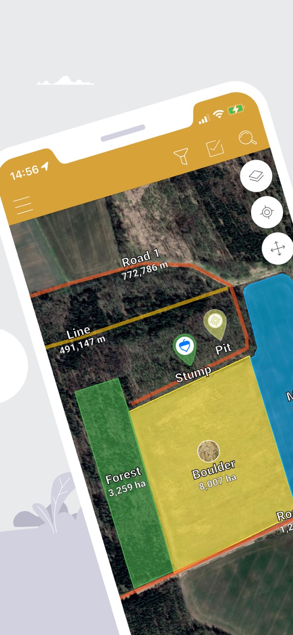
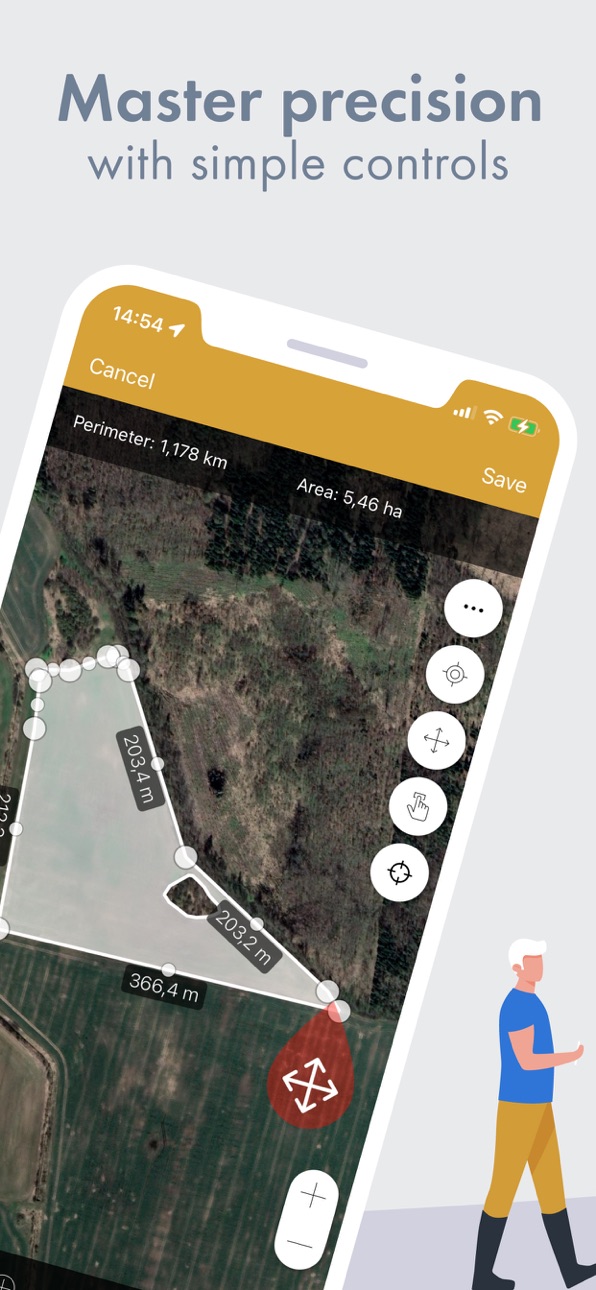
GPS Fields Area Measure lets you accurately calculate distance, perimeter and area — even without internet.
Mark any point with notes, photos or custom data. Ideal for field scouting, equipment tracking, land inspection or issue logging.
Designed for:
-------------
• Farmers & agronomists (field mapping, crop scouting, fertilizer & spray planning, issue logging)
• Land surveyors & construction (fencing, irrigation layout)
• Real estate & property teams (map parcels and store notes, photos & site info)
Key Features:
-------------
• One-tap GPS walking/driving measurement
• Precise manual editing with point markers
• Add notes, photos & custom objects
• Fully offline — works anywhere
• Save, group & edit projects
• Export to KML, KMZ or Shapefile
• Add custom map layers — drone imagery, raster maps or any WMS service
• Elevation profiles & built-in compass
What our users say:
-------------------
“Best measuring app I’ve ever used. Replaced my expensive handheld GPS.” — John, USA
“Perfect for remote areas with no signal.” — Maria, UK
“Great for property inspections. All my notes, photos and boundaries are stored in one app — no more messy folders.” — Mark, Australia
4.6 stars from 11K+ reviews • Used in 150+ countries • Regular feature updates
Download free. Unlock Premium for advanced tools and cloud storage.
• Privacy policy: https://privacy.farmis.com/
• Terms of Use: https://privacy.farmis.com/
In-App Purchases EE pricing
Synchronisation Subscription
1 month premium subscription · Monthly—
6 months premium subscription · 6 months—
12 months premium subscription · Yearly—
Premium 1 week · 7 days—
Capabilities
In-App Purchases
Accessibility
ipadiphonemacrealityDevicetvoswatch
Version history 25 versions
Build 883915745v2.34.02026-05-20 15:24:34
- New! Unit converter
- New! Split field using grid
- Improved coordinate editing
- UI, performance improvements
- Bug fixes
Build 883551987v2.33.02026-03-23 07:11:46
- Improved coordinate search — now supports multiple formats (UTM, DDM, Decimal Degrees, and more)
- New! Support for national coordinate systems (EPSG)
- Updated search with map marker placement
- Improved coordinate editing
- UI, performance improvements and bug fixes
Build 883063186v2.32.02026-03-12 11:41:53
- New! Using coordinates in multiple formats: UTM, DMS, DDM, Decimal Degrees.
- UTM coordinates can now be included when sharing measurements as PDF
- Option to hide or show previous measurements while making new measurements
- UI improvements and bug fixes
Build 882636289v2.31.02026-02-27 07:05:34
- New export options! CSV, DXF, TXT and GPX formats
- Introducing UTM coordinates option.
Build 880109168v2.30.02026-01-25 19:05:30
-Improved GPS mode visibility by making color change indicate the mode
-Fixed issues with units and opacity settings
-Small UI updates
-Bug fixes
Build 877863825v2.29.22025-09-08 10:11:14
Bug fixes and performance improvements
Build 877130129v2.29.12025-08-14 10:54:49
- Bug fixes and performance improvements
Build 876774835v2.29.02025-07-30 14:58:19
- New feature: add icons to your measurements on the map
- Bug fixes
Build 876443104v2.28.02025-07-18 06:30:43
- Bug fixes and performance improvements
Build 876004721v2.27.02025-07-09 14:43:56
- New Notes feature: add descriptions and photos
- New Measurement Info Card with bottom sheet design
- "Groups" feature updated: view all group measures with one click
- New options to export coordinates in PDF format
- New feature: create measurement by scanning coordinates
- Added ability to move polygons and distances
- Added option to duplicate measurements
- Bug fixes and performance improvements
Build 873304184v2.26.22025-03-18 21:42:01
-Bug fixes
Build 873172495v2.26.12025-03-12 15:01:39
-Bug fixes
Build 873114899v2.26.02025-03-10 22:19:43
-Bug fixes
Build 872814682v2.25.12025-02-27 09:20:35
-Bug fixes
Build 872774488v2.25.02025-02-26 06:54:54
-Resolved some crashes for a smoother experience
-Optimized internal processes for better performance
-Bug fixes
Build 872294998v2.24.02025-02-11 06:51:47
-Improved PDF export with new formatting options
-Resolved crashing issues
-Bug fixes
Build 872079992v2.23.02025-01-29 11:40:51
-The 'Hide group' feature has returned to the Groups section.
-Added a new export option: you can now export measurements as a .jpg file for easier printing.
-Added the option to turn off measurement labels.
Build 871615657v2.22.12025-01-12 19:52:27
-Bug Fixes
Build 871335776v2.22.02025-01-08 12:11:33
-Introducing custom styling, choose measurement opacity and border thickness
-Option to export the whole measurement group
-Option to assign group while importing measurements
-Other import improvements
-Minor usage improvements
-Bug Fixes
Build 871035604v2.21.22024-12-11 06:49:43
- Bug fixes
Build 870942319v2.21.12024-12-09 06:50:27
- Bug fixes
Build 870838324v2.21.02024-12-05 08:30:56
- Improved way of showing images on fields
- Distance between points added
- Additional mode for long click
- Compass added to the map
- Important Bug fixes
Build 870532033v2.20.12024-11-21 06:18:51
- Improved performance
- Bug fixes
- Other minor usage improvements
Build 870185719v2.20.02024-11-14 14:53:01
- Freehand mode for quick area measuring
- Grid layout to view measurements
- Long-click and drag action to multiselect measurements in list
- Proximity Sorting to find closest and farthest measures from current GPS location
- Updated sorting options
- Naming of exported files
- Bug fixes
Build 869616694v2.19.02024-10-16 07:16:12
- Group search implemented
- Map multi-select mode added
- Drag to select multiple objects on the map
- Option to select/deselect visible objects
- Measurement count now shown next to type and group
- Hybrid and Satellite map layers added
- Field direction arrow added
Price history by region
Currency
Show
Columns
Search
Availability 114 of 114 storefronts
| Region | Language | Price | Ratings | Avg | Version |
|---|---|---|---|---|---|
| US | en-US | Free | 12.2k | 4.6 | 2.34.0 |
| IN | en-GB | Free | 7.6k | 4.5 | 2.34.0 |
| KH | en-GB | Free | 7.2k | 4.6 | 2.34.0 |
| AR | es-MX | Free | 3.2k | 4.8 | 2.34.0 |
| TH | en-GB | Free | 2.2k | 4.7 | 2.34.0 |
| RU | ru | Free | 1.9k | 4.8 | 2.34.0 |
| UA | en-GB | Free | 1.7k | 4.8 | 2.34.0 |
| RO | en-GB | Free | 1.6k | 4.7 | 2.34.0 |
| KZ | en-GB | Free | 1.6k | 4.9 | 2.34.0 |
| VN | en-GB | Free | 1.6k | 4.7 | 2.34.0 |
| IT | it | Free | 1.4k | 4.6 | 2.34.0 |
| UZ | en-GB | Free | 1.4k | 4.8 | 2.34.0 |
| GB | en-GB | Free | 1.3k | 4.6 | 2.34.0 |
| NZ | en-AU | Free | 1.2k | 4.6 | 2.34.0 |
| AU | en-AU | Free | 1.2k | 4.6 | 2.34.0 |
| ID | en-GB | Free | 1.1k | 4.8 | 2.34.0 |
| ES | es-ES | Free | 1.1k | 4.6 | 2.34.0 |
| CA | en-CA | Free | 956 | 4.5 | 2.34.0 |
| PT | pt-PT | Free | 946 | 4.6 | 2.34.0 |
| PY | es-MX | Free | 867 | 4.8 | 2.34.0 |
| FR | fr-FR | Free | 865 | 4.6 | 2.34.0 |
| ZA | en-GB | Free | 832 | 4.6 | 2.34.0 |
| DE | de-DE | Free | 803 | 4.5 | 2.34.0 |
| IE | en-GB | Free | 750 | 4.6 | 2.34.0 |
| KG | en-GB | Free | 719 | 4.8 | 2.34.0 |
| TR | en-GB | Free | 632 | 4.6 | 2.34.0 |
| LK | en-GB | Free | 564 | 4.6 | 2.34.0 |
| DO | es-MX | Free | 406 | 4.7 | 2.34.0 |
| AZ | en-GB | Free | 374 | 4.9 | 2.34.0 |
| PK | en-GB | Free | 371 | 4.6 | 2.34.0 |
| BG | en-GB | Free | 364 | 4.7 | 2.34.0 |
| GR | en-GB | Free | 330 | 4.6 | 2.34.0 |
| PH | en-GB | Free | 317 | 4.6 | 2.34.0 |
| HU | en-GB | Free | 305 | 4.8 | 2.34.0 |
| CR | es-MX | Free | 279 | 4.7 | 2.34.0 |
| MY | en-GB | Free | 277 | 4.7 | 2.34.0 |
| MM | en-GB | Free | 273 | 4.5 | 2.34.0 |
| AM | en-GB | Free | 270 | 4.9 | 2.34.0 |
| BO | es-MX | Free | 270 | 4.7 | 2.34.0 |
| SG | en-GB | Free | 261 | 4.7 | 2.34.0 |
| KR | ko | Free | 256 | 4.6 | 2.34.0 |
| EC | es-MX | Free | 250 | 4.9 | 2.34.0 |
| AL | en-GB | Free | 236 | 4.7 | 2.34.0 |
| SA | en-GB | Free | 216 | 4.6 | 2.34.0 |
| PL | en-GB | Free | 211 | 4.7 | 2.34.0 |
| MD | en-GB | Free | 209 | 4.8 | 2.34.0 |
| NL | nl | Free | 197 | 4.6 | 2.34.0 |
| TW | zh-Hant-TW | Free | 180 | 4.8 | 2.34.0 |
| VE | es-MX | Free | 167 | 4.8 | 2.34.0 |
| EG | en-GB | Free | 136 | 4.4 | 2.34.0 |
| PA | es-MX | Free | 130 | 4.8 | 2.34.0 |
| LT | en-GB | Free | 124 | 4.7 | 2.34.0 |
| BY | en-GB | Free | 123 | 4.8 | 2.34.0 |
| IQ | en-GB | Free | 119 | 4.7 | 2.34.0 |
| BE | en-GB | Free | 118 | 4.6 | 2.34.0 |
| AE | en-GB | Free | 115 | 4.6 | 2.34.0 |
| HR | en-GB | Free | 114 | 4.8 | 2.34.0 |
| IL | en-GB | Free | 111 | 4.5 | 2.34.0 |
| TJ | en-GB | Free | 110 | 4.9 | 2.34.0 |
| JP | ja | Free | 103 | 4.4 | 2.34.0 |
| RS | en-GB | Free | 103 | 4.8 | 2.34.0 |
| SN | en-GB | Free | 103 | 4.3 | 2.34.0 |
| GE | en-GB | Free | 100 | 4.8 | 2.34.0 |
| LV | en-GB | Free | 94 | 4.8 | 2.34.0 |
| CH | de-CH | Free | 92 | 4.7 | 2.34.0 |
| MN | en-GB | Free | 91 | 4.7 | 2.34.0 |
| XK | en-GB | Free | 87 | 4.9 | 2.34.0 |
| AO | en-GB | Free | 86 | 4.5 | 2.34.0 |
| CN | zh-Hans-CN | Free | 82 | 4.7 | 2.34.0 |
| LA | en-GB | Free | 76 | 4.7 | 2.34.0 |
| DK | en-GB | Free | 73 | 4.5 | 2.34.0 |
| CZ | en-GB | Free | 67 | 4.7 | 2.34.0 |
| TN | en-GB | Free | 62 | 4.5 | 2.34.0 |
| SE | sv | Free | 59 | 4.4 | 2.34.0 |
| AT | de-DE | Free | 56 | 4.7 | 2.34.0 |
| SK | en-GB | Free | 51 | 4.7 | 2.34.0 |
| TM | en-GB | Free | 45 | 4.6 | 2.34.0 |
| CY | en-GB | Free | 36 | 4.8 | 2.34.0 |
| SI | en-GB | Free | 35 | 4.8 | 2.34.0 |
| NP | en-GB | Free | 34 | 4.5 | 2.34.0 |
| QA | en-GB | Free | 32 | 4.4 | 2.34.0 |
| AF | en-GB | Free | 30 | 4.5 | 2.34.0 |
| MK | en-GB | Free | 27 | 4.9 | 2.34.0 |
| YE | en-GB | Free | 27 | 4.2 | 2.34.0 |
| BA | en-GB | Free | 25 | 4.4 | 2.34.0 |
| MR | en-GB | Free | 24 | 4.2 | 2.34.0 |
| JO | en-GB | Free | 23 | 4.9 | 2.34.0 |
| LB | en-GB | Free | 23 | 4.3 | 2.34.0 |
| OM | en-GB | Free | 23 | 4.8 | 2.34.0 |
| PW | en-GB | Free | 21 | 4.9 | 2.34.0 |
| NO | en-GB | Free | 19 | 4.6 | 2.34.0 |
| FI | en-GB | Free | 17 | 4.3 | 2.34.0 |
| KW | en-GB | Free | 17 | 4.5 | 2.34.0 |
| HK | zh-Hant-HK | Free | 12 | 4.5 | 2.34.0 |
| BT | en-GB | Free | 11 | 4.5 | 2.34.0 |
| FJ | en-GB | Free | 8 | 4.1 | 2.34.0 |
| EE | en-GB | Free | 7 | 4.4 | 2.34.0 |
| LU | en-GB | Free | 6 | 4.5 | 2.34.0 |
| BH | en-GB | Free | 5 | 4.6 | 2.34.0 |
| ME | en-GB | Free | 4 | 5.0 | 2.34.0 |
| BN | en-GB | Free | 3 | 5.0 | 2.34.0 |
| IS | en-GB | Free | 3 | 5.0 | 2.34.0 |
| PG | en-GB | Free | 3 | 4.7 | 2.34.0 |
| TO | en-GB | Free | 3 | 4.0 | 2.34.0 |
| MT | en-GB | Free | 2 | 5.0 | 2.34.0 |
| VU | en-GB | Free | 2 | 5.0 | 2.34.0 |
| CV | en-GB | Free | 1 | 5.0 | 2.34.0 |
| MO | zh-Hant-HK | Free | 1 | 5.0 | 2.34.0 |
| SB | en-GB | Free | 1 | 5.0 | 2.34.0 |
| BM | en-GB | Free | 0 | — | 2.34.0 |
| BS | en-GB | Free | 0 | — | 2.34.0 |
| FM | en-GB | Free | 0 | — | 2.34.0 |
| MV | en-GB | Free | 0 | — | 2.34.0 |
| NR | en-GB | Free | 0 | — | 2.34.0 |
Change log 29 changes · EE
✎
releaseNotes updated
- New! Unit converter
- New! Split field using grid
- Improved coordinate editing
- UI, performance improvements
- Bug fixes
✎
description updated
GPS Fields Area Measure lets you accurately calculate distance, perimeter and area — even without internet.
Mark any point with notes, photos or custom data. I
✎
subtitle updated
Distance, acres, boundaries
✎
name updated
GPS Fields Area Measure Map
◆
Version 2.34.0 released
- New! Unit converter
- New! Split field using grid
- Improved coordinate editing
- UI, performance improvements
- Bug fixes
◆
Version 2.33.0 released
- Improved coordinate search — now supports multiple formats (UTM, DDM, Decimal Degrees, and more)
- New! Support for national coordinate systems (EPSG)
- Updated search with map marker placement
- Improved coordinate editing
- UI, performa
◆
Version 2.32.0 released
- New! Using coordinates in multiple formats: UTM, DMS, DDM, Decimal Degrees.
- UTM coordinates can now be included when sharing measurements as PDF
- Option to hide or show previous measurements while making new measurements
- UI improvem
◆
Version 2.31.0 released
- New export options! CSV, DXF, TXT and GPX formats
- Introducing UTM coordinates option.
◆
Version 2.30.0 released
-Improved GPS mode visibility by making color change indicate the mode
-Fixed issues with units and opacity settings
-Small UI updates
-Bug fixes
◆
Version 2.29.2 released
Bug fixes and performance improvements
◆
Version 2.29.1 released
- Bug fixes and performance improvements
◆
Version 2.29.0 released
- New feature: add icons to your measurements on the map
- Bug fixes
◆
Version 2.28.0 released
- Bug fixes and performance improvements
◆
Version 2.27.0 released
- New Notes feature: add descriptions and photos
- New Measurement Info Card with bottom sheet design
- "Groups" feature updated: view all group measures with one click
- New options to export coordinates in PDF format
- New feature: create
◆
Version 2.26.2 released
-Bug fixes
◆
Version 2.26.1 released
-Bug fixes
◆
Version 2.26.0 released
-Bug fixes
◆
Version 2.25.1 released
-Bug fixes
◆
Version 2.25.0 released
-Resolved some crashes for a smoother experience
-Optimized internal processes for better performance
-Bug fixes
◆
Version 2.24.0 released
-Improved PDF export with new formatting options
-Resolved crashing issues
-Bug fixes
◆
Version 2.23.0 released
-The 'Hide group' feature has returned to the Groups section.
-Added a new export option: you can now export measurements as a .jpg file for easier printing.
-Added the option to turn off measurement labels.
◆
Version 2.22.1 released
-Bug Fixes
◆
Version 2.22.0 released
-Introducing custom styling, choose measurement opacity and border thickness
-Option to export the whole measurement group
-Option to assign group while importing measurements
-Other import improvements
-Minor usage improvements
-Bug F
◆
Version 2.21.2 released
- Bug fixes
◆
Version 2.21.1 released
- Bug fixes
◆
Version 2.21.0 released
- Improved way of showing images on fields
- Distance between points added
- Additional mode for long click
- Compass added to the map
- Important Bug fixes
◆
Version 2.20.1 released
- Improved performance
- Bug fixes
- Other minor usage improvements
◆
Version 2.20.0 released
- Freehand mode for quick area measuring
- Grid layout to view measurements
- Long-click and drag action to multiselect measurements in list
- Proximity Sorting to find closest and farthest measures from current GPS location
- Updated sorti
◆
Version 2.19.0 released
- Group search implemented
- Map multi-select mode added
- Drag to select multiple objects on the map
- Option to select/deselect visible objects
- Measurement count now shown next to type and group
- Hybrid and Satellite map layers added
-