Home › Productivity

 CA
CA
 USen-US
 BRpt-BR
 ARes-MX
 AUen-AU
 BEen-GB
 BSen-GBCAen-CA
 CHde-CH
 CLes-MX
 CRes-MX
 DEde-DE
 DKen-GB
 ECes-MX
 ESes-ES
 FIen-GB
 FRfr-FR
 GBen-GB
 GTes-MX
 IEen-GB
 LCen-GB
 MXes-MX
 NLnl
NLnl NOen-GB
 NZen-AU
 PEes-MX
 SEsv
SEsv VGen-GB
 AENot Available
 AFNot Available
 AGNot Available
 AINot Available
 ALNot Available
 AMNot Available
 AONot Available
 ATNot Available
 AZNot Available
 BANot Available
 BBNot Available
 BFNot Available
 BGNot Available
 BHNot Available
 BMNot Available
 BNNot Available
 BONot Available
 BTNot Available
 BWNot Available
 BYNot Available
 BZNot Available
 CINot Available
 CMNot Available
 CNNot Available
 CONot Available
 CVNot Available
 CYNot Available
 CZNot Available
 DMNot Available
 DONot Available
 DZNot Available
 EENot Available
 EGNot Available
 FJNot Available
 FMNot Available
 GDNot Available
 GENot Available
 GHNot Available
 GMNot Available
 GRNot Available
 GWNot Available
 GYNot Available
 HKNot Available
 HNNot Available
 HRNot Available
 HUNot Available
 IDNot Available
 ILNot Available
 INNot Available
 IQNot Available
 ISNot Available
 ITNot Available
 JMNot Available
 JONot Available
 JPNot Available
 KENot Available
 KGNot Available
 KHNot Available
 KNNot Available
 KRNot Available
 KWNot Available
 KYNot Available
 KZNot Available
 LANot Available
 LBNot Available
 LKNot Available
 LRNot Available
 LTNot Available
 LUNot Available
 LVNot Available
 LYNot Available
 MANot Available
 MDNot Available
 MENot Available
 MGNot Available
 MKNot Available
 MLNot Available
 MMNot Available
 MNNot Available
 MONot Available
 MRNot Available
 MSNot Available
 MTNot Available
 MUNot Available
 MVNot Available
 MWNot Available
 MYNot Available
 MZNot Available
 NANot Available
 NGNot Available
 NINot Available
 NPNot Available
 NRNot Available
 OMNot Available
 PANot Available
 PGNot Available
 PHNot Available
 PKNot Available
 PLNot Available
 PTNot Available
 PWNot Available
 PYNot Available
 QANot Available
 RONot Available
 RSNot Available
 RUNot Available
 RWNot Available
 SANot Available
 SBNot Available
 SCNot Available
 SGNot Available
 SINot Available
 SKNot Available
 SLNot Available
 SNNot Available
 SRNot Available
 STNot Available
 SVNot Available
 SZNot Available
 TCNot Available
 TDNot Available
 THNot Available
 TJNot Available
 TMNot Available
 TNNot Available
 TONot Available
 TRNot Available
 TTNot Available
 TWNot Available
 TZNot Available
 UANot Available
 UGNot Available
 UYNot Available
 UZNot Available
 VCNot Available
 VENot Available
 VNNot Available
 VUNot Available
 XKNot Available
 YENot Available
 ZANot Available
 ZMNot Available
 ZWNot Available
27 of 170 storefronts
Content in en-CA
Content in en-CA
Information
Preview 2 platforms
iPhone 8 images


iPad 8 images




What’s New Version 25.3.4
IMPROVED: Sync optimizations.
Description
Ecobot Collector is the mobile app for field data collection within the Ecobot platform. Capture accurate field data, map features, organize photos, and complete required forms with workflows designed specifically for wetlands, streams, and natural resources assessments. Collector helps you eliminate repetitive data entry so you can stay focused on the scientific insight your clients rely on.
Collector pairs with Ecobot Manager, the web-based part of the platform, to create a connected field-to-office workflow. Together, they keep your data consistent, organized, and ready for reporting.
WHY ENVIRONMENTAL SCIENTISTS USE ECOBOT
Accurate field data
Standardized data entry, photo organization, calculations, and references support clear and defensible documentation.
Built for real field conditions
Work online or offline. Collector saves entries locally and syncs when you are back online. Unsynced data alerts keep you confident that nothing is left behind.
More time for science
Fast entry, smart defaults, and automated calculations reduce time spent on paperwork and rework.
Consistent data across your team
Unified mobile and web workflows reduce variation and help teams deliver reliable results. Project Merge and Project Transfer let you simplify large projects and reassign ownership easily.
Connected to Ecobot Manager
Review, manage, QA, and export data from the web with enhanced photo editing, favorites, rotation, and multi-image tools. Two-factor authentication and role-based permissions support better team controls.
KEY FEATURES
Field data collection for wetlands, streams, and natural resources
Capture vegetation, soils, hydrology indicators, OHWM observations, and more. Record photos with mapped metadata and build automated project photo logs. Work entirely offline when needed.
Standardized forms and automated calculations
Use USACE Regional Wetland Determination Data Sheets, USACE Rapid OHWM, and NC DWQ Stream Identification forms. Collector automates indicators, dominance ratios, prevalence indices, and other required calculations.
Integrated mapping
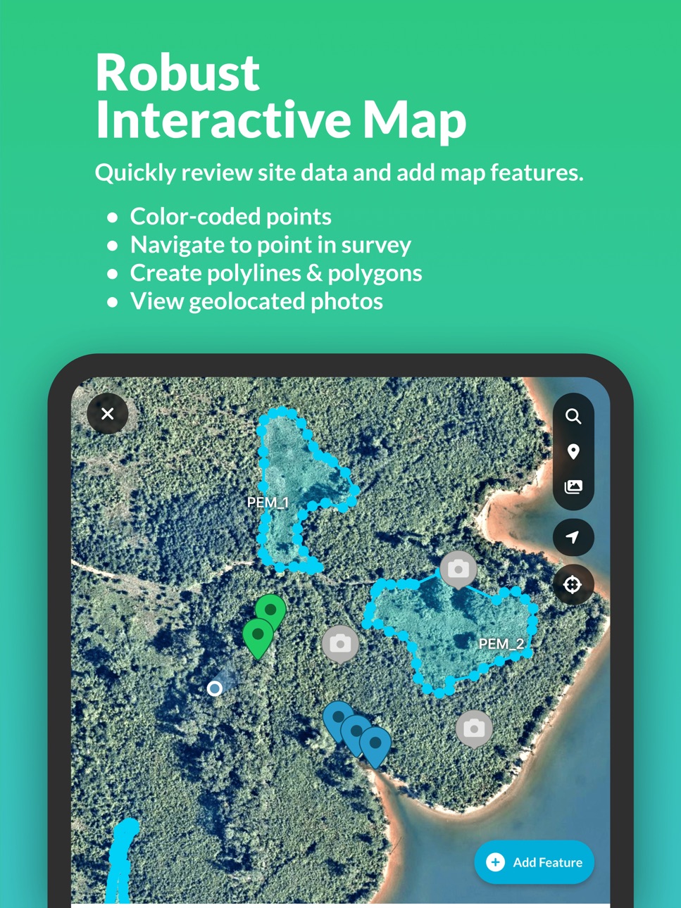
Drop points, lines, and polygons. Navigate to features. View geolocated photos. Use mobile GPS or compatible GNSS receivers in the field. Jump directly to features and photos from the home screen.
Advanced photo tools
Capture, organize, and sort photos instantly. Tag favorites, rotate incorrectly oriented images, and use incremental loading for faster viewing. Use Ecobot Manager to review and QA photos efficiently.
Survey and workflow enhancements
Enjoy distraction-free survey views, color-coded status indicators, new manage-survey modal, and direct navigation between points, features, and photos.
Team and security features
Project Merge and Project Transfer simplify large-scale workflows and team reorganization. Unsynced data alerts and device naming support field-office alignment. Two-factor authentication and role-based permissions bring enterprise-grade controls.
Secure data storage
Ecobot uses AWS-backed infrastructure so your project data is safely stored, backed up, and accessible.
Ecobot is built by environmental consultants and trusted by leading AEC firms. With connected mobile and web workflows, Ecobot helps teams collect accurate data, reduce rework, and deliver consistent, defensible results.
ECOBOT® is a trademark of Ecobot, Inc. Patent pending.
Accessibility
ipadiphonemacrealityDevicetvoswatch
Version history 25 versions
Build 883440717v25.3.42026-03-20 12:47:33
IMPROVED: Sync optimizations.
Build 881285274v25.3.32026-01-12 16:03:21
NEW: Project Merge & Transfer — combine or reassign projects.
NEW: Device Naming & Sync Alerts — track devices and prevent unsynced data.
IMPROVED: Photo Tools — favorites, rotation, faster thumbnails, smoother
review.
IMPROVED: Survey Workflow — cleaner UI, color statuses, quick map jumps.
IMPROVED: Performance — faster sync and stronger offline tiles.
IMPROVED: Performance — faster sync
SECURITY UPDATE: Role-based permissions and 2FA.
IMPROVED: Sync optimizations.
Build 880124154v25.3.12025-11-27 13:12:03
NEW: Project Merge & Project Transfer — easily combine or reassign large-scale projects across your team.
NEW: Unsynced Data Alerts & Device Naming — keep track of field devices and ensure all survey data is synced before you head back to the office.
IMPROVED: Advanced Photo Tools — now with favorites, image rotation, faster thumbnails and seamless review in Ecobot Manager.
IMPROVED: Survey Workflow & Navigation — fresh distraction-free view, color-coded statuses, and jump-to-feature capability straight from the map.
IMPROVED: Performance & Offline Stability — faster sync, fresh UI updates, and enhanced offline tile support for map features.
IMPROVED: Sync optimizations.
SECURITY UPDATE: Role-Based Permissions & Two-Factor Authentication support added for team administrators.
BUG FIXES & general enhancements across Collector and Manager.
Build 876334825v25.3.02025-11-23 02:12:40
NEW: Project Merge & Project Transfer — easily combine or reassign large-scale projects across your team.
NEW: Unsynced Data Alerts & Device Naming — keep track of field devices and ensure all survey data is synced before you head back to the office.
IMPROVED: Advanced Photo Tools — now with favorites, image rotation, faster thumbnails and seamless review in Ecobot Manager.
IMPROVED: Survey Workflow & Navigation — fresh distraction-free view, color-coded statuses, and jump-to-feature capability straight from the map.
IMPROVED: Performance & Offline Stability — faster sync, fresh UI updates, and enhanced offline tile support for map features.
SECURITY UPDATE: Role-Based Permissions & Two-Factor Authentication support added for team administrators.
BUG FIXES & general enhancements across Collector and Manager.
Build 875002392v4.9.22025-05-27 13:02:48
NEW: Multi image support for vegetation ID.
UPDATE: Camera improvements.
Build 874652871v4.9.12025-05-21 18:04:50
NEW: Multi image support for vegetation ID.
UPDATE: Camera improvements.
Build 872859823v4.8.02025-02-28 12:21:21
NEW: 2024 USACE regional wetland determination forms.
NEW: Updated NWI Citation.
Build 871981987v4.7.02025-01-24 14:42:38
NEW: Recently used landforms
NEW: Add photos from the camera roll
NEW: Save photo to the camera roll
NEW: Camera controls: focus and zoom
NEW: Plant ID now displays the plant's status based on the project's region
Bug fixes and improvements
Build 870222515v4.6.12024-11-06 10:05:55
Bug fixes and improvements.
Build 869960195v4.6.02024-10-28 04:34:25
NEW: Vegetation Lookup powered by AI
NEW: Built in NC DWQ Stream ID manual
Build 869655353v4.5.02024-10-14 06:45:17
NEW: NC DWQ Stream Identification Form
IMPROVED: Customize map layers
Build 869005401v4.4.02024-09-16 19:28:49
NEW: Automated soil suggestions for hydric indicators.
NEW: Camera in point. Capture photos at any time during data collection.
NEW: Matrix color swatch to help verify color fields.
Build 868820041v4.3.42024-09-08 10:35:03
Bug fixes and improvements.
Build 868726553v4.3.32024-09-04 10:45:00
Bug fixes and improvements.
Build 868604343v4.3.12024-09-01 17:57:29
NEW: Tap a point to see more details and navigate to it. Search for survey points easily.
NEW: Photos appear directly on the map. Tap photo icon to view photo details and access the full photo gallery.
NEW: Fetch location to automate wetland point fields: subregion, soil map unit, NWI, section township range, county, and state from point coordinate.
NEW: General Field Observation (GFO) form to drop any point on a map, add photos and title/description.
IMPROVED: Survey points are color-coded—green for uplands and blue for wetlands.
IMPROVED: Investigator field added to new survey setup.
Build 867666174v4.2.32024-07-23 00:11:05
Bug fixes and improvements.
Build 867585872v4.2.22024-07-18 18:24:34
NEW: Support for auto check in
IMPROVED: Photo Sync
Build 867497926v4.2.12024-07-16 01:19:31
Bug fixes and improvements.
Build 867331201v4.2.02024-07-09 00:34:19
NEW: Added Photos feature for capturing, editing, and managing photos in the field. Photo capture page includes compass direction and location metadata. Associate photos with survey points, add titles and descriptions, and mark favorites. Edit photos to make changes or delete as needed. Manage images with a resizable photo grid, sorting by favorites for quick access.
Build 866367030v4.1.112024-06-01 08:25:55
We're always making Ecobot better. Enable updates and never miss out on our latest features and improvements.
Build 866342144v4.1.102024-05-31 02:12:54
Bug fixes and improvements.
Build 866312072v4.1.92024-05-30 07:42:33
IMPROVED: Sync speed
IMPROVED: Update notifications
NEW: Add points without coordinates
Build 866175395v4.1.72024-05-29 02:49:23
IMPROVED: Sync speed
IMPROVED: Update notifications
NEW: Add points without coordinates
Build 864626296v4.1.22024-03-22 01:45:39
Vegetation improvements
Build 864206762v4.1.12024-03-05 02:31:21
Bug fixes and improvements.
No pricing data captured yet — comparisons appear once the app has paid storefronts or in-app purchases.
Availability 27 of 170 storefronts
| Region | Language | Price | Ratings | Avg | Version |
|---|---|---|---|---|---|
| US | en-US | Free | 133 | 4.9 | 25.3.4 |
| BR | pt-BR | Free | 2 | 5.0 | 25.3.4 |
| AR | es-MX | Free | 0 | — | 25.3.4 |
| AU | en-AU | Free | 0 | — | 25.3.4 |
| BE | en-GB | Free | 0 | — | 25.3.4 |
| BS | en-GB | Free | 0 | — | 25.3.4 |
| CA | en-CA | Free | 0 | — | 25.3.4 |
| CH | de-CH | Free | 0 | — | 25.3.4 |
| CL | es-MX | Free | 0 | — | 25.3.4 |
| CR | es-MX | Free | 0 | — | 25.3.4 |
| DE | de-DE | Free | 0 | — | 25.3.4 |
| DK | en-GB | Free | 0 | — | 25.3.4 |
| EC | es-MX | Free | 0 | — | 25.3.4 |
| ES | es-ES | Free | 0 | — | 25.3.4 |
| FI | en-GB | Free | 0 | — | 25.3.4 |
| FR | fr-FR | Free | 0 | — | 25.3.4 |
| GB | en-GB | Free | 0 | — | 25.3.4 |
| GT | es-MX | Free | 0 | — | 25.3.4 |
| IE | en-GB | Free | 0 | — | 25.3.4 |
| LC | en-GB | Free | 0 | — | 25.3.4 |
| MX | es-MX | Free | 0 | — | 25.3.4 |
| NL | nl | Free | 0 | — | 25.3.4 |
| NO | en-GB | Free | 0 | — | 25.3.4 |
| NZ | en-AU | Free | 0 | — | 25.3.4 |
| PE | es-MX | Free | 0 | — | 25.3.4 |
| SE | sv | Free | 0 | — | 25.3.4 |
| VG | en-GB | Free | 0 | — | 25.3.4 |
Not available in: AE, AF, AG, AI, AL, AM, AO, AT, AZ, BA, BB, BF, BG, BH, BM, BN, BO, BT, BW, BY, BZ, CI, CM, CN, CO, CV, CY, CZ, DM, DO, DZ, EE, EG, FJ, FM, GD, GE, GH, GM, GR, GW, GY, HK, HN, HR, HU, ID, IL, IN, IQ, IS, IT, JM, JO, JP, KE, KG, KH, KN, KR, KW, KY, KZ, LA, LB, LK, LR, LT, LU, LV, LY, MA, MD, ME, MG, MK, ML, MM, MN, MO, MR, MS, MT, MU, MV, MW, MY, MZ, NA, NG, NI, NP, NR, OM, PA, PG, PH, PK, PL, PT, PW, PY, QA, RO, RS, RU, RW, SA, SB, SC, SG, SI, SK, SL, SN, SR, ST, SV, SZ, TC, TD, TH, TJ, TM, TN, TO, TR, TT, TW, TZ, UA, UG, UY, UZ, VC, VE, VN, VU, XK, YE, ZA, ZM, ZW
Change log 29 changes · CA
✎
releaseNotes updated
IMPROVED: Sync optimizations.
✎
description updated
Ecobot Collector is the mobile app for field data collection within the Ecobot platform. Capture accurate field data, map features, organize photos, and complet
✎
subtitle updated
Collect environmental data
✎
name updated
Ecobot Collector
◆
Version 25.3.4 released
IMPROVED: Sync optimizations.
◆
Version 25.3.3 released
NEW: Project Merge & Transfer — combine or reassign projects.
NEW: Device Naming & Sync Alerts — track devices and prevent unsynced data.
IMPROVED: Photo Tools — favorites, rotation, faster thumbnails, smoother
review.
IMPROVED: Survey Wor
◆
Version 25.3.1 released
NEW: Project Merge & Project Transfer — easily combine or reassign large-scale projects across your team.
NEW: Unsynced Data Alerts & Device Naming — keep track of field devices and ensure all survey data is synced before you head back to t
◆
Version 25.3.0 released
NEW: Project Merge & Project Transfer — easily combine or reassign large-scale projects across your team.
NEW: Unsynced Data Alerts & Device Naming — keep track of field devices and ensure all survey data is synced before you head back to t
◆
Version 4.9.2 released
NEW: Multi image support for vegetation ID.
UPDATE: Camera improvements.
◆
Version 4.9.1 released
NEW: Multi image support for vegetation ID.
UPDATE: Camera improvements.
◆
Version 4.8.0 released
NEW: 2024 USACE regional wetland determination forms.
NEW: Updated NWI Citation.
◆
Version 4.7.0 released
NEW: Recently used landforms
NEW: Add photos from the camera roll
NEW: Save photo to the camera roll
NEW: Camera controls: focus and zoom
NEW: Plant ID now displays the plant's status based on the project's region
Bug fixes and improvements
◆
Version 4.6.1 released
Bug fixes and improvements.
◆
Version 4.6.0 released
NEW: Vegetation Lookup powered by AI
NEW: Built in NC DWQ Stream ID manual
◆
Version 4.5.0 released
NEW: NC DWQ Stream Identification Form
IMPROVED: Customize map layers
◆
Version 4.4.0 released
NEW: Automated soil suggestions for hydric indicators.
NEW: Camera in point. Capture photos at any time during data collection.
NEW: Matrix color swatch to help verify color fields.
◆
Version 4.3.4 released
Bug fixes and improvements.
◆
Version 4.3.3 released
Bug fixes and improvements.
◆
Version 4.3.1 released
NEW: Tap a point to see more details and navigate to it. Search for survey points easily.
NEW: Photos appear directly on the map. Tap photo icon to view photo details and access the full photo gallery.
NEW: Fetch location to automate wetlan
◆
Version 4.2.3 released
Bug fixes and improvements.
◆
Version 4.2.2 released
NEW: Support for auto check in
IMPROVED: Photo Sync
◆
Version 4.2.1 released
Bug fixes and improvements.
◆
Version 4.2.0 released
NEW: Added Photos feature for capturing, editing, and managing photos in the field. Photo capture page includes compass direction and location metadata. Associate photos with survey points, add titles and descriptions, and mark favorites. E
◆
Version 4.1.11 released
We're always making Ecobot better. Enable updates and never miss out on our latest features and improvements.
◆
Version 4.1.10 released
Bug fixes and improvements.
◆
Version 4.1.9 released
IMPROVED: Sync speed
IMPROVED: Update notifications
NEW: Add points without coordinates
◆
Version 4.1.7 released
IMPROVED: Sync speed
IMPROVED: Update notifications
NEW: Add points without coordinates
◆
Version 4.1.2 released
Vegetation improvements
◆
Version 4.1.1 released
Bug fixes and improvements.