Home › Navigation

 PH
PH
 HNes-MX
 LVen-GB
 USen-US
 AFen-GB
 ALen-GB
 AOen-GB
 AZen-GB
 BAen-GB
 BGen-GB
 BMen-GB
 BYen-GB
 CVen-GB
 CYen-GB
 EEen-GB
 EGen-GB
 GEen-GB
 GRen-GB
 GTes-MX
 HRen-GB
 IDen-GB
 INen-GB
 KRko
KRko LKen-GB
 LTen-GB
 LUen-GB
 MDen-GB
 MEen-GB
 MKen-GB
 MOzh-Hant-HK
 MRen-GB
 MTen-GB
 MYen-GB
 NIes-MX
 NPen-GBPHen-GB
 PKen-GB
 RSen-GB
 RUru
RUru SGen-GB
 SIen-GB
 SNen-GB
 SVes-MX
 THen-GB
 TRen-GB
 TWzh-Hant-TW
 UAen-GB
 VNen-GB
 XKen-GB
48 of 48 storefronts
Content in en-US
Content in en-US
Information
Preview 2 platforms
iPhone 6 images



iPad 6 images


What’s New Version 4.2.1
This update adds two new zoom levels to the map, making the terrain map more detailed than before.
Description
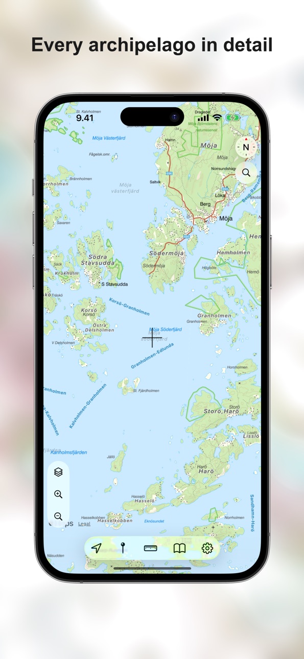
Topo maps - Sweden puts Lantmäteriet's detailed topographic map of Sweden right in your pocket. From mountain trails and forest roads to the archipelago, you've got a clear outdoor map that keeps working when reception disappears.
The map covers Sweden at practical outdoor scales and looks sharp on Retina displays.
What's inside
- Full offline use — download any area to your device and leave reception behind
- Tracks and waypoints, with GPX import and export (folders stay intact)
- Ruler for measuring distances on the map
- Display, copy, and search coordinates in WGS84 (DD, DDM, DMS), ETRS-TM35FIN, MGRS, UTM / ETRS89, SWEREF 99 TM, and ETRS-GK
- Drop a base camp and navigate back to it whenever you need
- Address and place search with recents and autocomplete
- Apple street and satellite maps when you need a different view
A small note on GPS: tracking in the background drains the battery faster than usual, so keep an eye on it on longer trips.
Map data: © Lantmäteriet
Accessibility
ipadiphonemacrealityDevicetvoswatch
Version history 19 versions
Build 886067435v4.2.12026-05-31 18:14:39
This update adds two new zoom levels to the map, making the terrain map more detailed than before.
Build 885819460v4.2.02026-05-20 23:17:23
This update adds:
- New coordinate systems for the map and coordinate search: MGRS, UTM / ETRS89, SWEREF 99 TM, and ETRS-GK.
- Live Activity support for track recording.
- Sorting for bookmarks.
Build 885042416v4.0.12026-05-03 19:12:04
We're back — and the app has had a proper rebuild.
It took a while (sorry about that), but under the hood this is very nearly a fresh start. Same topo maps and outdoor tools, just cleaner, faster, and happier on modern devices.
A few things you might notice:
- Offline map downloads now have a dedicated screen with clearer progress
- GPX import and export keep folder structure intact
- Track, navigation, and ruler distances now follow your unit settings
- Search has been reworked with autocomplete and recents
- Snappier in-app indicators thanks to a rebuilt loading HUD
- The "Details" button on track and route callouts now opens the details
Thanks for sticking around.
Build 884805915v4.0.02026-04-26 18:16:48
We're back — and the app has had a proper rebuild.
It took a while (sorry about that), but under the hood this is very nearly a fresh start. Same topo maps and outdoor tools, just cleaner, faster, and happier on modern devices.
A few things you might notice:
- Offline map downloads now have a dedicated screen with clearer progress
- GPX import and export keep folder structure intact
- Track, navigation, and ruler distances now follow your unit settings
- Search has been reworked with autocomplete and recents
- Snappier in-app indicators thanks to a rebuilt loading HUD
- The "Details" button on track and route callouts now opens the details
Thanks for sticking around.
Build 875791951v3.7.22025-06-22 22:31:02
Problem med kartinläsning åtgärdat
Build 875544200v3.7.12025-06-12 20:16:23
Minor fixes
Build 871149993v3.7.02024-12-16 09:41:11
Removed location sharing as it no longer worked reliably.
Build 848160977v3.6.32022-07-06 23:21:33
Minor improvements
Build 842042240v3.6.22021-06-22 22:37:03
All 3rd party analytics removed
Build 836968488v3.6.12020-07-26 19:56:54
- Improved GPX handling
- Basecamp feature improvements
- Faster map loading
- Heading arrow
- iPad bug fixes
- Better compatibilty with dark mode
Build 835720957v3.5.12020-04-28 15:08:06
Minor improvements
Build 835605214v3.5.02020-04-19 16:39:42
- Much better maps. You can now zoom much closer than before.
- Pointer and Ruler tools improved for usability
- A lot of smaller under the hood improvements
Build 835121996v3.3.32020-03-29 19:43:54
A lot of improvements and new features!
- Search
- Zoom buttons and support for tap-to-zoom
- Ability to use Apple's street map and satellite images
- A lot of other smaller improvements
Build 828926768v1.0.52018-10-17 16:39:43
Performance fixes
Build 819083003v1.0.42016-09-30 00:12:38
- Scale indicator fixed
Build 818507096v1.0.32016-09-12 23:08:47
- Optimization
Build 816793121v1.0.22016-03-27 17:59:46
- A lot of larger area can be downloaded for offline use
Build 816655239v1.0.12016-03-11 21:22:09
- Tips & Tricks fixed
- Optimization
- New icon
Build 816510294v1.02016-02-25 18:38:41
Price history by region
Currency
Show
Columns
Search
Availability 48 of 48 storefronts
| Region | Language | Price | Ratings | Avg | Version |
|---|---|---|---|---|---|
| HN | es-MX | USD 3.99 | 1 | 5.0 | 4.2.1 |
| LV | en-GB | EUR 3.99 | 1 | 5.0 | 4.2.1 |
| US | en-US | USD 3.99 | 1 | 5.0 | 4.2.1 |
| AF | en-GB | USD 3.99 | 0 | — | 4.2.1 |
| AL | en-GB | USD 4.99 | 0 | — | 4.2.1 |
| AO | en-GB | USD 3.99 | 0 | — | 4.2.1 |
| AZ | en-GB | USD 4.99 | 0 | — | 4.2.1 |
| BA | en-GB | EUR 3.99 | 0 | — | 4.2.1 |
| BG | en-GB | EUR 3.99 | 0 | — | 4.2.1 |
| BM | en-GB | USD 3.99 | 0 | — | 4.2.1 |
| BY | en-GB | USD 4.99 | 0 | — | 4.2.1 |
| CV | en-GB | USD 3.99 | 0 | — | 4.2.1 |
| CY | en-GB | EUR 3.99 | 0 | — | 4.2.1 |
| EE | en-GB | EUR 3.99 | 0 | — | 4.2.1 |
| EG | en-GB | EGP 199.99 | 0 | — | 4.2.1 |
| GE | en-GB | USD 4.99 | 0 | — | 4.2.1 |
| GR | en-GB | EUR 3.99 | 0 | — | 4.2.1 |
| GT | es-MX | USD 3.99 | 0 | — | 4.2.1 |
| HR | en-GB | EUR 3.99 | 0 | — | 4.2.1 |
| ID | en-GB | IDR 69000 | 0 | — | 4.2.1 |
| IN | en-GB | INR 399 | 0 | — | 4.2.1 |
| KR | ko | KRW 6600 | 0 | — | 4.2.1 |
| LK | en-GB | USD 3.99 | 0 | — | 4.2.1 |
| LT | en-GB | EUR 3.99 | 0 | — | 4.2.1 |
| LU | en-GB | EUR 3.99 | 0 | — | 4.2.1 |
| MD | en-GB | USD 4.99 | 0 | — | 4.2.1 |
| ME | en-GB | EUR 3.99 | 0 | — | 4.2.1 |
| MK | en-GB | USD 3.99 | 0 | — | 4.2.1 |
| MO | zh-Hant-HK | USD 3.99 | 0 | — | 4.2.1 |
| MR | en-GB | USD 3.99 | 0 | — | 4.2.1 |
| MT | en-GB | EUR 3.99 | 0 | — | 4.2.1 |
| MY | en-GB | MYR 19.9 | 0 | — | 4.2.1 |
| NI | es-MX | USD 3.99 | 0 | — | 4.2.1 |
| NP | en-GB | USD 4.99 | 0 | — | 4.2.1 |
| PH | en-GB | PHP 249 | 0 | — | 4.2.1 |
| PK | en-GB | PKR 1100 | 0 | — | 4.2.1 |
| RS | en-GB | EUR 3.99 | 0 | — | 4.2.1 |
| RU | ru | RUB 349 | 0 | — | 4.2.1 |
| SG | en-GB | SGD 5.98 | 0 | — | 4.2.1 |
| SI | en-GB | EUR 3.99 | 0 | — | 4.2.1 |
| SN | en-GB | USD 4.99 | 0 | — | 4.2.1 |
| SV | es-MX | USD 3.99 | 0 | — | 4.2.1 |
| TH | en-GB | THB 149 | 0 | — | 4.2.1 |
| TR | en-GB | TRY 199.99 | 0 | — | 4.2.1 |
| TW | zh-Hant-TW | TWD 120 | 0 | — | 4.2.1 |
| UA | en-GB | USD 4.99 | 0 | — | 4.2.1 |
| VN | en-GB | VND 119000 | 0 | — | 4.2.1 |
| XK | en-GB | EUR 3.99 | 0 | — | 4.2.1 |
Change log 23 changes · PH
✎
releaseNotes updated
This update adds two new zoom levels to the map, making the terrain map more detailed than before.
✎
description updated
Topo maps - Sweden puts Lantmäteriet's detailed topographic map of Sweden right in your pocket. From mountain trails and forest roads to the archipelago, you've
✎
subtitle updated
Detailed topo maps
✎
name updated
Topo maps - Sweden
◆
Version 4.2.1 released
This update adds two new zoom levels to the map, making the terrain map more detailed than before.
◆
Version 4.2.0 released
This update adds:
- New coordinate systems for the map and coordinate search: MGRS, UTM / ETRS89, SWEREF 99 TM, and ETRS-GK.
- Live Activity support for track recording.
- Sorting for bookmarks.
◆
Version 4.0.1 released
We're back — and the app has had a proper rebuild.
It took a while (sorry about that), but under the hood this is very nearly a fresh start. Same topo maps and outdoor tools, just cleaner, faster, and happier on modern devices.
A few thin
◆
Version 4.0.0 released
We're back — and the app has had a proper rebuild.
It took a while (sorry about that), but under the hood this is very nearly a fresh start. Same topo maps and outdoor tools, just cleaner, faster, and happier on modern devices.
A few thin
◆
Version 3.7.2 released
Problem med kartinläsning åtgärdat
◆
Version 3.7.1 released
Minor fixes
◆
Version 3.7.0 released
Removed location sharing as it no longer worked reliably.
◆
Version 3.6.3 released
Minor improvements
◆
Version 3.6.2 released
All 3rd party analytics removed
◆
Version 3.6.1 released
- Improved GPX handling
- Basecamp feature improvements
- Faster map loading
- Heading arrow
- iPad bug fixes
- Better compatibilty with dark mode
◆
Version 3.5.1 released
Minor improvements
◆
Version 3.5.0 released
- Much better maps. You can now zoom much closer than before.
- Pointer and Ruler tools improved for usability
- A lot of smaller under the hood improvements
◆
Version 3.3.3 released
A lot of improvements and new features!
- Search
- Zoom buttons and support for tap-to-zoom
- Ability to use Apple's street map and satellite images
- A lot of other smaller improvements
◆
Version 1.0.5 released
Performance fixes
◆
Version 1.0.4 released
- Scale indicator fixed
◆
Version 1.0.3 released
- Optimization
◆
Version 1.0.2 released
- A lot of larger area can be downloaded for offline use
◆
Version 1.0.1 released
- Tips & Tricks fixed
- Optimization
- New icon
◆
Version 1.0 released