Home › Business

 US
US
 ALen-GB
 AMen-GB
 ATde-DE
 AUen-AU
 AZen-GB
 BAen-GB
 BEen-GB
 BGen-GB
 BYen-GB
 CAen-CA
 CHde-CH
 CYen-GB
 CZen-GB
 DEde-DE
 DKen-GB
 EEen-GB
 EGen-GB
 ESes-ES
 FIen-GB
 FRfr-FR
 GBen-GB
 GEen-GB
 GRen-GB
 HRen-GB
 HUen-GB
 IEen-GB
 ILen-GB
 IQen-GB
 ISen-GB
 ITit
ITit LBen-GB
 LTen-GB
 LUen-GB
 LVen-GB
 MDen-GB
 MEen-GB
 MKen-GB
 MTen-GB
 NLnl
NLnl NOen-GB
 NZen-AU
 PLen-GB
 PTpt-PT
 ROen-GB
 RSen-GB
 RUru
RUru SAen-GB
 SEsv
SEsv SIen-GB
 SKen-GB
 TRen-GB
 UAen-GBUSen-US
 XKen-GB
 YEen-GB
55 of 55 storefronts
Content in en-US
Content in en-US
Information
Apple ID6765971349
Bundle IDcom.qconp.seainfomap
SellerSeller
Min iOS13.0
Min macOS11.0
Device familiesiphone, ipad, ipod
Released2026-06-24
Copyright© 2026 qconp
Privacy policyLink ↗
Preview 2 platforms
iPhone 7 images




iPad 6 images


What’s New Version 1.1.1
Optimized map data usage and rendering performance.
Description
Sea Info Map brings tides, weather, ocean and astronomy together in a single map pin — built for working on and around the water.
■ Offline tide graph
High-accuracy tide prediction runs entirely on your device, using official harmonic constants. Even offshore with no signal, see high/low tide times, spring/neap tides, and the continuous tide curve. Covers 239 reference ports across Japan.
■ Map overlays (heat-map layers)
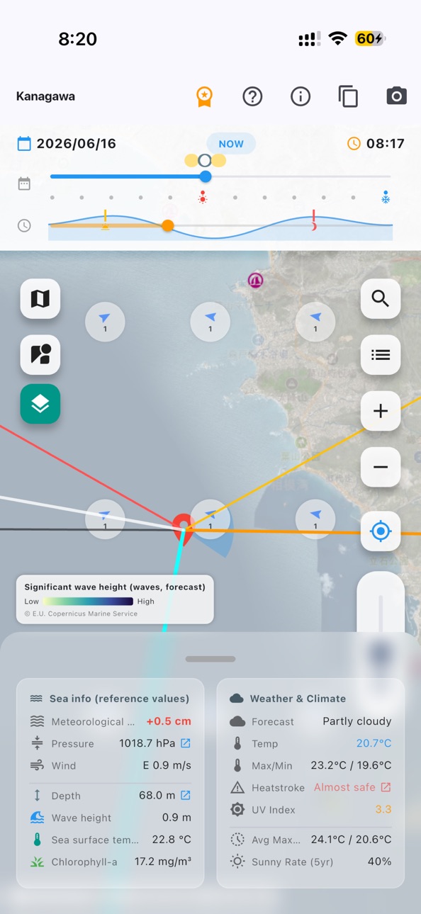
Overlay sea surface temperature (SST), chlorophyll-a (a fishing-ground / tide-line indicator), significant wave height and ocean currents as color layers on the map. Temperature fronts (tide lines) and strong-current bands such as the Kuroshio stand out at a glance. SST uses the latest ~5 km gap-free data and is shown from launch. Wave and current layers are forecast-aware and animate with the time slider.
■ Wind
Wind arrows show where the wind is blowing (direction + speed), so you can read wind direction and strength at a glance. Forecast-aware and synced to the time slider.
■ Charts & base map
Satellite / standard base maps with OpenSeaMap nautical marks (lighthouses, buoys, navigation aids, depth marks) overlaid. The day/night terminator is shown too.
■ Point data (tap to read)
Temperature, wind speed/direction, pressure, precipitation chance, UV index and conditions; SST, currents, wave height, chlorophyll-a and depth. Also an estimate of how pressure (inverse barometer) and wind (set-up) may raise/lower the actual water level, plus a heat-stress (heatstroke) alert.
■ Astronomy (offline)
Sunrise/sunset, moonrise/moonset and moon phase — handy for night fishing and night work.
■ Time slider
Drag the date/time slider at the bottom and the tide curve, weather, ocean data and map overlays (forecast, up to ~10 days ahead) update together on the map — from the past into the future.
■ Favorites & CSV export
Save your go-to spots and export tide (high/low), weather and ocean data to CSV for reports and records.
■ Made for
- Fishing (shore, boat, breakwater)
- Fisheries and aquaculture
- Marine construction, harbor work, diving operations
- Diving and marine leisure
- Operating small craft
Note: data in this app is a planning/leisure reference only and is not a substitute for official nautical charts or tide tables. Use official sources for navigation and safety.
Tide data: Japan Meteorological Agency (https://www.data.jma.go.jp/)
Ocean data: NOAA CoastWatch, E.U. Copernicus Marine Service Information (DOI: 10.48670/moi-00017)
Maps: Mapbox / OpenStreetMap / OpenSeaMap
Terms of Use (EULA): https://www.apple.com/legal/internet-services/itunes/dev/stdeula/
In-App Purchases US pricing
Sea Info Map Subscription
Monthly · Monthly$15.00
Sun Map Clock Yearly · Yearly$150.00
Capabilities
In-App Purchases
Accessibility
ipadiphonemacrealityDevicetvoswatch
Version history 2 versions
Build 887646038v1.1.12026-07-01 04:38:56
Optimized map data usage and rendering performance.
Build 885197398v1.1.02026-06-24 14:30:57
Price history by region
Currency
Show
Columns
Search
Availability 55 of 55 storefronts
| Region | Language | Price | Ratings | Avg | Version |
|---|---|---|---|---|---|
| AL | en-GB | Free | 0 | — | 1.1.1 |
| AM | en-GB | Free | 0 | — | 1.1.1 |
| AT | de-DE | Free | 0 | — | 1.1.1 |
| AU | en-AU | Free | 0 | — | 1.1.1 |
| AZ | en-GB | Free | 0 | — | 1.1.1 |
| BA | en-GB | Free | 0 | — | 1.1.1 |
| BE | en-GB | Free | 0 | — | 1.1.1 |
| BG | en-GB | Free | 0 | — | 1.1.1 |
| BY | en-GB | Free | 0 | — | 1.1.1 |
| CA | en-CA | Free | 0 | — | 1.1.1 |
| CH | de-CH | Free | 0 | — | 1.1.1 |
| CY | en-GB | Free | 0 | — | 1.1.1 |
| CZ | en-GB | Free | 0 | — | 1.1.1 |
| DE | de-DE | Free | 0 | — | 1.1.1 |
| DK | en-GB | Free | 0 | — | 1.1.1 |
| EE | en-GB | Free | 0 | — | 1.1.1 |
| EG | en-GB | Free | 0 | — | 1.1.1 |
| ES | es-ES | Free | 0 | — | 1.1.1 |
| FI | en-GB | Free | 0 | — | 1.1.1 |
| FR | fr-FR | Free | 0 | — | 1.1.1 |
| GB | en-GB | Free | 0 | — | 1.1.1 |
| GE | en-GB | Free | 0 | — | 1.1.1 |
| GR | en-GB | Free | 0 | — | 1.1.1 |
| HR | en-GB | Free | 0 | — | 1.1.1 |
| HU | en-GB | Free | 0 | — | 1.1.1 |
| IE | en-GB | Free | 0 | — | 1.1.1 |
| IL | en-GB | Free | 0 | — | 1.1.1 |
| IQ | en-GB | Free | 0 | — | 1.1.1 |
| IS | en-GB | Free | 0 | — | 1.1.1 |
| IT | it | Free | 0 | — | 1.1.1 |
| LB | en-GB | Free | 0 | — | 1.1.1 |
| LT | en-GB | Free | 0 | — | 1.1.1 |
| LU | en-GB | Free | 0 | — | 1.1.1 |
| LV | en-GB | Free | 0 | — | 1.1.1 |
| MD | en-GB | Free | 0 | — | 1.1.1 |
| ME | en-GB | Free | 0 | — | 1.1.1 |
| MK | en-GB | Free | 0 | — | 1.1.1 |
| MT | en-GB | Free | 0 | — | 1.1.1 |
| NL | nl | Free | 0 | — | 1.1.1 |
| NO | en-GB | Free | 0 | — | 1.1.1 |
| NZ | en-AU | Free | 0 | — | 1.1.1 |
| PL | en-GB | Free | 0 | — | 1.1.1 |
| PT | pt-PT | Free | 0 | — | 1.1.1 |
| RO | en-GB | Free | 0 | — | 1.1.1 |
| RS | en-GB | Free | 0 | — | 1.1.1 |
| RU | ru | Free | 0 | — | 1.1.1 |
| SA | en-GB | Free | 0 | — | 1.1.1 |
| SE | sv | Free | 0 | — | 1.1.1 |
| SI | en-GB | Free | 0 | — | 1.1.1 |
| SK | en-GB | Free | 0 | — | 1.1.1 |
| TR | en-GB | Free | 0 | — | 1.1.1 |
| UA | en-GB | Free | 0 | — | 1.1.1 |
| US | en-US | Free | 0 | — | 1.1.1 |
| XK | en-GB | Free | 0 | — | 1.1.1 |
| YE | en-GB | Free | 0 | — | 1.1.1 |
Change log 6 changes · US
✎
releaseNotes updated
Optimized map data usage and rendering performance.
✎
description updated
Sea Info Map brings tides, weather, ocean and astronomy together in a single map pin — built for working on and around the water.
■ Offline tide graph
High-acc
✎
subtitle updated
Tide charts & marine weather
✎
name updated
Sea Info Map -Tides,Fishing
◆
Version 1.1.1 released
Optimized map data usage and rendering performance.
◆
Version 1.1.0 released