Home › Navigation

Altimate Pilot Flight Planning
Weather, METAR, NOTAM, Logbook
 US
US
 AGen-GB
 AIen-GB
 AOen-GB
 ARes-MX
 BBen-GB
 BFen-GB
 BJen-GB
 BOes-MX
 BRpt-BR
 BSen-GB
 BWen-GB
 BZen-GB
 CDen-GB
 CGen-GB
 CIfr-FR
 CLes-MX
 CMfr-FR
 COes-MX
 CRes-MX
 CVen-GB
 DMen-GB
 DOes-MX
 DZen-GB
 ECes-MX
 GAfr-FR
 GDen-GB
 GHen-GB
 GMen-GB
 GTes-MX
 GWen-GB
 GYen-GB
 HNes-MX
 JMen-GB
 KEen-GB
 KNen-GB
 KYen-GB
 LCen-GB
 LRen-GB
 LYen-GB
 MAen-GB
 MGen-GB
 MLen-GB
 MSen-GB
 MUen-GB
 MWen-GB
 MXes-MX
 MZen-GB
 NAen-GB
 NEen-GB
 NGen-GB
 NIes-MX
 PAes-MX
 PEes-MX
 PYes-MX
 RWen-GB
 SCen-GB
 SLen-GB
 SNen-GB
 SRen-GB
 STen-GB
 SVes-MX
 SZen-GB
 TCen-GB
 TDen-GB
 TNen-GB
 TTen-GB
 TZen-GB
 UGen-GBUSen-US
 UYen-GB
 VCen-GB
 VEes-MX
 VGen-GB
 ZMen-GB
 ZWen-GB
75 of 75 storefronts
Content in en-US
Content in en-US
Information
Preview 2 platforms
iPhone 6 images



iPad 1 image

Description
PLAN. FLY. LOG. CONNECT: Altimate Pilot is an all-in-one companion for private pilots who are tired of juggling 5+ apps before every flight.
It combines weather, flight planning, navigation, digital logbook and other essential pilot tools in one powerful and user-friendly app.
WHY PILOTS CHOOSE ALTIMATE PILOT
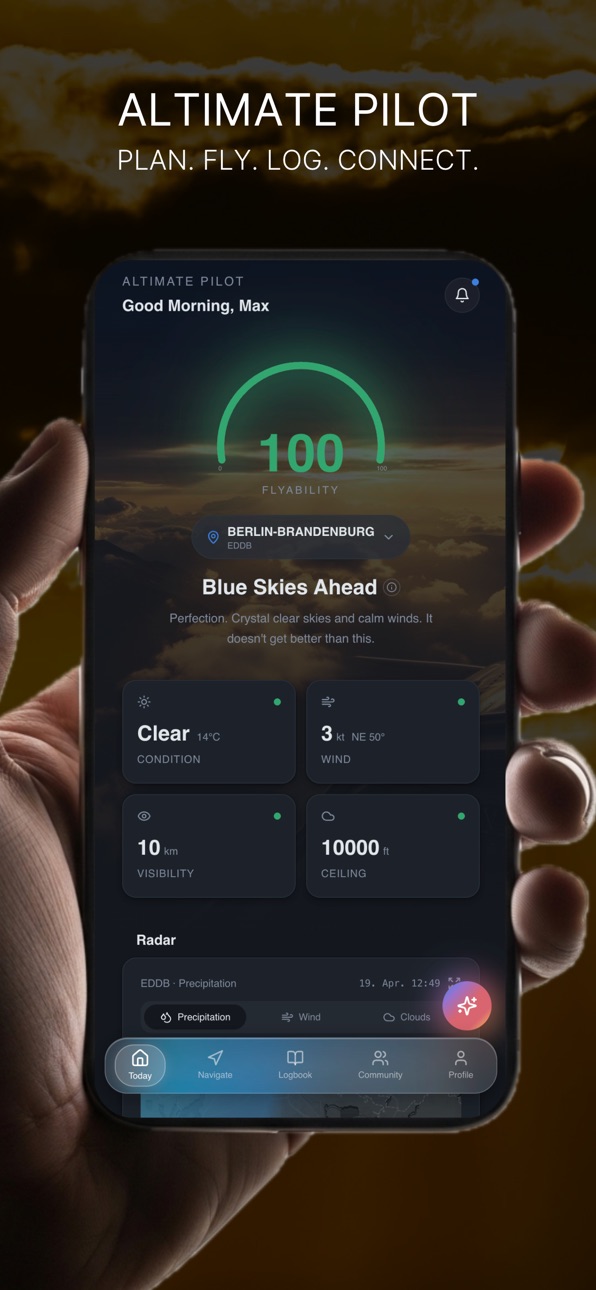
• Flyability Score: one 0–100 score from live METAR data to nail your go/no-go decision
• Weather Suite: METAR, TAF, NOTAM + AI copilot, radar, 7-day forecast, sunrise/sunset
• Flight Planning & Navigation: route planning with auto-calculated flight time and fuel, airspace overlays, back-to-back navigation
• Digital Logbook: manual entry, camera import from paper logbooks, auto-logging via navigation, statistics & Excel export
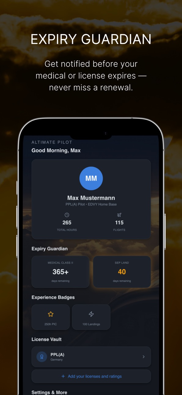
• Expiry Guardian: get notified before your medical or license lapses
• Community: share flights, find local events, connect with pilots near you
FLYABILITY SCORE — INSTANT GO / NO-GO
The Flyability Score combines wind, visibility, ceiling, and weather into a simple 0–100 rating - so you know if conditions are suitable for VFR flight at any airport or along your route.
AVIATION WEATHER, SIMPLIFIED
• Wind, visibility, ceiling, and clouds at a glance
• METAR, TAF, SIGMET decoded into plain language
• Color-coded flight categories (VFR, MVFR, IFR, LIFR)
• 7-day airport weather forecast worldwide
• NOTAMs filtered for relevance
VFR MAP & FLIGHT PLANNER
• Interactive VFR navigation map with airspaces
• Tap airports for runways, frequencies, elevation
• Plan multi-leg routes with headings and distance
• Visualize Flyability Scores directly on the map
• Weather radar overlay with precipitation, cloud, wind and SIGMET view
PILOT LOGBOOK (EASA standard)
• Log flights in seconds
• Personal flight statistics
• Automatic totals, currency, and flight time tracking
• Import paper logbook via photo and AI
• Track aircraft: callsign, TAS, fuel burn
EXPIRY TRACKING
Stay current and compliant. Track medicals, licenses, and ratings with smart reminders before expiry.
AI COPILOT
Ask questions about weather, airspace, and VFR flight planning—get instant, context-aware answers.
ALTIMATE PILOT PRO
Unlock full functionality:
• Live METAR, TAF, NOTAMs and SIGMETs (decoded)
• Flyability Score across routes and map
• Full digital logbook with sync and stats
• AI Copilot
• Expiry alerts and tracking
• Community features
Subscriptions auto-renew unless cancelled at least 24 hours before the end of the current period. Manage anytime in App Store settings.
BUILT FOR PILOTS
Download Altimate Pilot and turn your iPhone into a powerful VFR copilot.
Terms: https://altimatepilot.app/terms
Privacy: https://altimatepilot.app/privacy
In-App Purchases US pricing
Altimate Pilot Pro Subscription
Yearly · Monthly 1-month free trial$6.99
Yearly · Yearly 1-month free trial$69.99
Capabilities
In-App PurchasesWallet
Accessibility
ipadiphonemacrealityDevicetvoswatch
Version history 1 versions
Build 884420088v1.02026-06-17 14:00:54
Price history by region
Currency
Show
Columns
Search
Availability 75 of 75 storefronts
| Region | Language | Price | Ratings | Avg | Version |
|---|---|---|---|---|---|
| AG | en-GB | Free | 0 | — | 1.0 |
| AI | en-GB | Free | 0 | — | 1.0 |
| AO | en-GB | Free | 0 | — | 1.0 |
| AR | es-MX | Free | 0 | — | 1.0 |
| BB | en-GB | Free | 0 | — | 1.0 |
| BF | en-GB | Free | 0 | — | 1.0 |
| BJ | en-GB | Free | 0 | — | 1.0 |
| BO | es-MX | Free | 0 | — | 1.0 |
| BR | pt-BR | Free | 0 | — | 1.0 |
| BS | en-GB | Free | 0 | — | 1.0 |
| BW | en-GB | Free | 0 | — | 1.0 |
| BZ | en-GB | Free | 0 | — | 1.0 |
| CD | en-GB | Free | 0 | — | 1.0 |
| CG | en-GB | Free | 0 | — | 1.0 |
| CI | fr-FR | Free | 0 | — | 1.0 |
| CL | es-MX | Free | 0 | — | 1.0 |
| CM | fr-FR | Free | 0 | — | 1.0 |
| CO | es-MX | Free | 0 | — | 1.0 |
| CR | es-MX | Free | 0 | — | 1.0 |
| CV | en-GB | Free | 0 | — | 1.0 |
| DM | en-GB | Free | 0 | — | 1.0 |
| DO | es-MX | Free | 0 | — | 1.0 |
| DZ | en-GB | Free | 0 | — | 1.0 |
| EC | es-MX | Free | 0 | — | 1.0 |
| GA | fr-FR | Free | 0 | — | 1.0 |
| GD | en-GB | Free | 0 | — | 1.0 |
| GH | en-GB | Free | 0 | — | 1.0 |
| GM | en-GB | Free | 0 | — | 1.0 |
| GT | es-MX | Free | 0 | — | 1.0 |
| GW | en-GB | Free | 0 | — | 1.0 |
| GY | en-GB | Free | 0 | — | 1.0 |
| HN | es-MX | Free | 0 | — | 1.0 |
| JM | en-GB | Free | 0 | — | 1.0 |
| KE | en-GB | Free | 0 | — | 1.0 |
| KN | en-GB | Free | 0 | — | 1.0 |
| KY | en-GB | Free | 0 | — | 1.0 |
| LC | en-GB | Free | 0 | — | 1.0 |
| LR | en-GB | Free | 0 | — | 1.0 |
| LY | en-GB | Free | 0 | — | 1.0 |
| MA | en-GB | Free | 0 | — | 1.0 |
| MG | en-GB | Free | 0 | — | 1.0 |
| ML | en-GB | Free | 0 | — | 1.0 |
| MS | en-GB | Free | 0 | — | 1.0 |
| MU | en-GB | Free | 0 | — | 1.0 |
| MW | en-GB | Free | 0 | — | 1.0 |
| MX | es-MX | Free | 0 | — | 1.0 |
| MZ | en-GB | Free | 0 | — | 1.0 |
| NA | en-GB | Free | 0 | — | 1.0 |
| NE | en-GB | Free | 0 | — | 1.0 |
| NG | en-GB | Free | 0 | — | 1.0 |
| NI | es-MX | Free | 0 | — | 1.0 |
| PA | es-MX | Free | 0 | — | 1.0 |
| PE | es-MX | Free | 0 | — | 1.0 |
| PY | es-MX | Free | 0 | — | 1.0 |
| RW | en-GB | Free | 0 | — | 1.0 |
| SC | en-GB | Free | 0 | — | 1.0 |
| SL | en-GB | Free | 0 | — | 1.0 |
| SN | en-GB | Free | 0 | — | 1.0 |
| SR | en-GB | Free | 0 | — | 1.0 |
| ST | en-GB | Free | 0 | — | 1.0 |
| SV | es-MX | Free | 0 | — | 1.0 |
| SZ | en-GB | Free | 0 | — | 1.0 |
| TC | en-GB | Free | 0 | — | 1.0 |
| TD | en-GB | Free | 0 | — | 1.0 |
| TN | en-GB | Free | 0 | — | 1.0 |
| TT | en-GB | Free | 0 | — | 1.0 |
| TZ | en-GB | Free | 0 | — | 1.0 |
| UG | en-GB | Free | 0 | — | 1.0 |
| US | en-US | Free | 0 | — | 1.0 |
| UY | en-GB | Free | 0 | — | 1.0 |
| VC | en-GB | Free | 0 | — | 1.0 |
| VE | es-MX | Free | 0 | — | 1.0 |
| VG | en-GB | Free | 0 | — | 1.0 |
| ZM | en-GB | Free | 0 | — | 1.0 |
| ZW | en-GB | Free | 0 | — | 1.0 |
Change log 4 changes · US
✎
description updated
PLAN. FLY. LOG. CONNECT: Altimate Pilot is an all-in-one companion for private pilots who are tired of juggling 5+ apps before every flight.
It combines weathe
✎
subtitle updated
Weather, METAR, NOTAM, Logbook
✎
name updated
Altimate Pilot Flight Planning
◆
Version 1.0 released