Home › Navigation

 GB
GB
GBen-GB AFNot Available
 ALNot Available
 AMNot Available
 ATNot Available
 AUNot Available
 AZNot Available
 BANot Available
 BENot Available
 BGNot Available
 BMNot Available
 BNNot Available
 BTNot Available
 BYNot Available
 CANot Available
 CHNot Available
 CYNot Available
 CZNot Available
 DENot Available
 DKNot Available
 EENot Available
 EGNot Available
 ESNot Available
 FINot Available
 FJNot Available
 FMNot Available
 FRNot Available
 GENot Available
 GRNot Available
 HRNot Available
 HUNot Available
 IDNot Available
 IENot Available
 INNot Available
 IQNot Available
 ISNot Available
 ITNot Available
 JPNot Available
 KGNot Available
 KHNot Available
 KRNot Available
 KWNot Available
 KZNot Available
 LANot Available
 LKNot Available
 LTNot Available
 LUNot Available
 LVNot Available
 MDNot Available
 MENot Available
 MKNot Available
 MMNot Available
 MNNot Available
 MONot Available
 MRNot Available
 MTNot Available
 MVNot Available
 MYNot Available
 NLNot Available
 NONot Available
 NPNot Available
 NRNot Available
 NZNot Available
 PGNot Available
 PHNot Available
 PKNot Available
 PLNot Available
 PTNot Available
 PWNot Available
 RONot Available
 RSNot Available
 RUNot Available
 SBNot Available
 SENot Available
 SGNot Available
 SINot Available
 SKNot Available
 THNot Available
 TJNot Available
 TMNot Available
 TONot Available
 TRNot Available
 TWNot Available
 UANot Available
 UZNot Available
 VNNot Available
 VUNot Available
 XKNot Available
 YENot Available
 ZANot Available
1 of 90 storefronts
Content in en-US
Content in en-US
Information
Preview 2 platforms
iPhone 10 images





iPad 6 images


What’s New Version 2.6
Fixed a major overheating issue with the new auto-camera mode
Comes with improvements to CarPlay, including some major bug fixes
Traffic alerts and DVSA button have now been added to CarPlay
Route calculations should also be around 2 times faster
A new arrow mode under the Navigation section
Import places from TomTom
Pinned locations. You can pin your favs for example your Home or Yard. Pinned locations will appear on CarPlay too, just a single tap and off you go
A new ETA system that takes into consideration road speed limits instead of just your actual speed. This is much better than the old approach but not perfect. Traffic is still not taken into consideration.
Description
Michael is a navigation app for HGVs built and optimised for the UK.
It has the following features:
CarPlay support
• Height adjustments
• Length, width and weight settings
• Custom dimensions, enter your own
• Motorway gantry messages shown in advance for example you'll know of any accident 5 miles in advance
• Reaper mode. If you have ever used Delm8 or PostTag, this is a similar feature that identifies businesses on the map with precision. It is integrated for free and should only be used when needed
• Respect Time Restrictions feature that takes into consideration night time HGV road bans
• Live Traffic. When off routes are planned without taking traffic into consideration, this is useful when you want to stick to the main roads regardless of the waiting time in traffic
• Over 6,800 bridges added from Network Rail, so the chance of encountering a bridge en route is zero
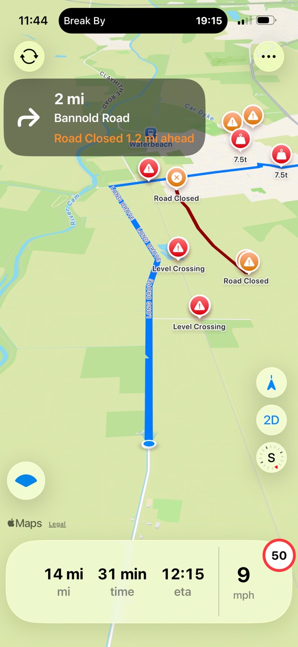
• Live road closures updated in real time by National Highways so you can plan ahead and see which ones may affect your route to the destination. No more surprises
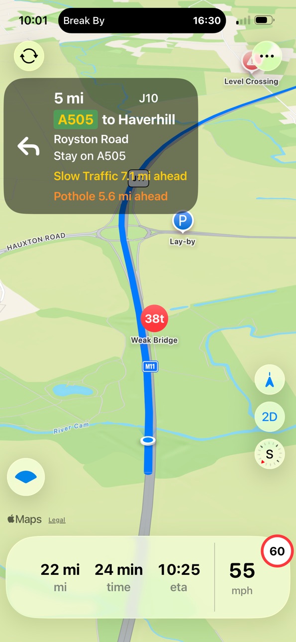
• Diversion routes and motorway variable message signs showing in real time what's going on ahead eg. Obstruction, slow traffic, incident, etc.
• School streets. The majority of school streets ban HGV access during drop off and pick up times. They are clearly marked on the map so you are aware if you are being routed through them. If you access one, you may risk a fine
• The parking section consists of lay-bys pinned on the map, HGV parking and industrial areas. Treat this with caution as the data is not 100 percent complete, so report anything missing
• Routing line and colour let you customise navigation
• London section includes emission zone boundaries, height restrictions, coach parking and live incidents. Data is provided in real time by TFL
• Night Shift mode takes your ETA and alerts you about any planned closures that may affect your route. It will not avoid closures automatically, so you must plan in advance
• Fuel stations and Greggs locations
• iPad support.
Terms: https://www.apple.com/legal/internet-services/itunes/dev/stdeula/
Privacy Policy: https://michaelhgv.co.uk/privacypolicy
In-App Purchases GB pricing
Choose Your Plan Subscription
Monthly · Monthly 3-day free trial£4.99
Annual · Yearly 3-day free trial£39.99
Capabilities
In-App Purchases
Accessibility
ipadiphonemacrealityDevicetvoswatch
Version history 17 versions
Build 887406992v2.62026-07-01 23:07:15
Fixed a major overheating issue with the new auto-camera mode
Comes with improvements to CarPlay, including some major bug fixes
Traffic alerts and DVSA button have now been added to CarPlay
Route calculations should also be around 2 times faster
A new arrow mode under the Navigation section
Import places from TomTom
Pinned locations. You can pin your favs for example your Home or Yard. Pinned locations will appear on CarPlay too, just a single tap and off you go
A new ETA system that takes into consideration road speed limits instead of just your actual speed. This is much better than the old approach but not perfect. Traffic is still not taken into consideration.
Build 887165846v2.52026-06-23 17:26:45
Comes with a new Auto Camera feature and the first version of CarPlay
The first version of CarPlay currently doesn't display traffic alerts. Support for this feature will be added later this month
Build 886888292v2.42026-06-13 01:26:07
Your vehicle profile won't survive app updates, unfortunately
First of all Waze alerts are now working at 100% capacity
Added to the While Driving section:
-Other Bridges, a separate dataset that complements the Network Rail bridges
-Junction numbers
-More lay-bys. Previously, we only had 7,000 locations; now it includes 39,000 locations.
-Speed cameras
-Level crossings and fords
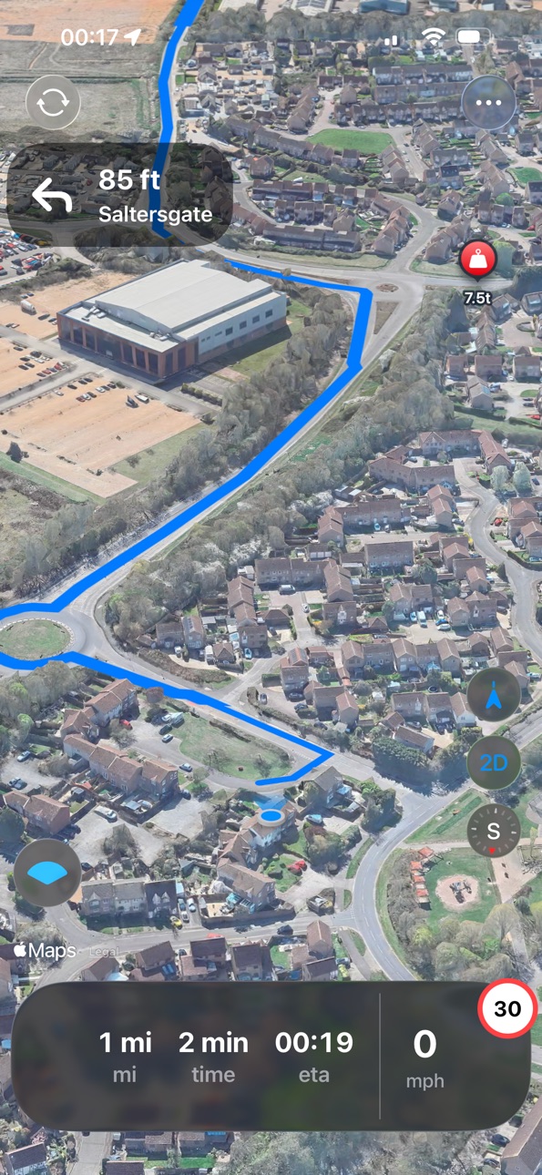
-Road restrictions (weight, length, width)
-Farm gates
-Weak bridges
-Abnormal-friendly lay-bys
-Lots of other features were added, along with many performance improvements.
Build 886122219v2.32026-06-02 11:45:16
Be aware that your saved profile will not survive app updates. Unfortunately, this inconvenience will remain until I stabilise the app
Added Markerpost Lookup
Added Waze, Google and TomTom traffic alerts
Added Traffic Lights and Crossings visible as you drive
Added recovery, horse box, tractor + trailer vehicle profiles
Improved the map view for road closures, diversions, etc.
Added LCS (Lorry Control Scheme) for London
Added 3D in Satellite Mode
Added a system where everyone can contribute by marking goods in locations, hazards, safe parking areas, and much more on the map
I’ve also improved the app’s performance significantly
Build 886031280v2.22026-05-23 02:14:45
Fixed an issue where Planning Mode was not working as expected.
Build 885936143v2.12026-05-21 22:36:45
This update may impact your saved profiles
Added tipper to vehicle profiles
Return Route lets you get back the same way you came
New and improved road closure management
Traffic incident design adjustments
Planning Mode now supports building your own route with waypoints, taking this mode to the next level
Lots of work has been done to improve performance
Build 885775071v2.02026-05-18 04:50:28
Comes with
First of all, fixed an issue where the display was auto-locking by itself.
• what3words integration – Simply copy and paste a what3words address into the search field.
• Avoid a specific road – Tap the map to avoid a specific road and the app will safely reroute you. This is also useful for avoiding blindside reversing.
• Traffic banners added – Upcoming traffic incidents are now shown below the directions as you drive. Updates every 15 minutes.
• Check for 7.5t restrictions – Zoom into your area of interest and tap “Check for 7.5t restrictions.”
• Design adjustments and many more improvements.
Build 885501421v1.92026-05-14 00:13:32
This update will reset your current vehicle settings. If you had Fuel Stations installed, you'll need to update the data, tap Update in the Fuel Stations section or delete and reinstall the app. Without doing this, upcoming motorway fuel stations won't appear
Added Car, Van, Caravan, Crane and Tractor vehicle profiles.
Crane & Abnormal Loads --- I’m collecting more information from industry experts and working on importing routes from services like ABhaulier. At the moment I can't offer much for routing
Save multiple vehicles and switch between them. Find the save button at the bottom of Vehicle Profile Settings.
Missed Turn --- The app reroutes in the direction you’re already travelling, as it should. A banner appears after a missed turn showing the next 3 roundabouts ahead to help you decide whether to turn around or continue with the alternative route. However, after passing the next 3 roundabouts, it assumes that you are sticking with the current alternative route and the roundabout banner disappears.
Multi-Stop changes --- When you pre-plan multiple drops, it hides the remaining drops until you have completed the current one. This helps remove overlapping map lines.
Sharp Turns --- Alerts you to any sharp turns detected along your route before you set off, giving you the chance to review before committing.
Upcoming Fuel Stations --- Shows the next motorway service station ahead in case you missed the signs. If you installed this previously, you’ll need to update Fuel Stations, otherwise, it won’t work.
Wind Conditions --- shows whether it's Calm, Breezy or Stormy at your destination. You're going there anyway, but good to know
Driving in London --- by default, rerouting kicks in when you hit 20 mph. In London or slow city traffic you may never reach that speed, so enable this to reroute as soon as you drift off course. Only turn it on if you actually drive in these conditions.
Stop Here --- This will appear at the top of the selected Fuel Station. Once you calculate a route and have Fuel Stations shown along the route, you can stop on your way. Bonus: toggle Greggs locations to check whether that fuel station has one
Lock Route --- Disables automatic rerouting. This is particularly useful for Saved Routes, where manoeuvring in a yard could accidentally trigger a route recalculation without you being aware and pull you off your saved route. The trade-off is that if there’s a road closure ahead and you get diverted, you won’t be rerouted automatically unless you manually tap the Recalculate button in the top-left corner. This button is a safety feature for such scenarios.
Speed Limit Sign --- Shows your real-time speed and displays the current road speed limit as a sign alongside it, similar to other satnavs. This is optional, toggle it in Vehicle Profile
Added axle weight and number of axles for custom dimensions
Route loading has been improved --- routes now calculate faster
Working on improving the traffic service. Currently at 30%
Build 885304207v1.82026-05-06 21:00:50
Lots of performance improvements, especially for long route calculations.
It also comes with STGO categories, fuel stations, Greggs locations, copy and paste coordinates in the search field, and saved locations/routes added to the main search for quick access.
Build 885253481v1.72026-05-04 21:31:38
Planning mode, calculate up to 10 stops
Fuel Stations is coming in the next update
Build 885208254v1.62026-05-03 21:14:34
Comes with many improvements to reduce lag. It is important to understand that because of the large number of datasets, the app can become overwhelmed, especially when navigating with all Explore (now renamed to Show on map) options enabled, which display all data on the map at once.
This has now been solved. When you start navigation, these options turn off automatically
I have also added a Storage section in Settings, accessed via the gear icon in the top right corner. It lets you delete data you do not use. For example, you may have installed Closures, School Streets, Emergency Areas, Diversion Routes, and Lay-bys and many more, but you may not actually need them. Remove what you do not use to free up space and reduce memory usage.
Build 885143805v1.52026-05-01 14:49:17
Live traffic now displays correctly on your route during navigation
Fixed an issue where the Emergency Areas (SOS) download would fail
Build 885001947v1.42026-04-29 01:58:04
Fixes the lag issue. This happened if you had any data installed from the London section. Under the hood, instead of loading bits of data, it was loading all data for London on the map in one go, which caused your phone to melt. This is now fixed
A cool feature I have added is the traffic service. When you calculate a route, it will take data from Google for traffic such as slow traffic and jams. It will update every 10 minutes along your journey. If you have used Google Maps before, it is the same traffic aware service. Make sure to also toggle on the Traffic Drone for live alerts
Slow traffic alerts within 1 mile.
Traffic jams will alert within 2 miles.
Note: Before starting navigation, make sure the “Explore” options are turned off. Keep only the “Alongside Route” options that are optimised for travelling.
Get in touch with me to suggest features.
Build 884902868v1.32026-04-25 16:48:06
This update comes with custom dimensions option, enter your own length, width and weight
Option to save a specific route: If you regularly travel the same route, you can save it and stick to it regardless of traffic or events. In other words, keep me on this route even if there’s 15–20 minutes of traffic, don’t send me through city centres or country lanes. You can save multiple routes and name them as you wish.
Coach routing, I won’t neglect coach drivers :)
Motorway navigation banners: These will show upcoming events in advance. For example, you’ll know about accidents up to 5 miles ahead, giving you a heads-up
Points of Interest in Navigation: When turned off, this removes businesses, petrol stations, hotels, and shops from the map. This is useful if your device is older and you don’t need the extra overhead
Motorway and major A roads emergency areas and telephones + designated bus and coach stopping points on the Strategic Road Network
Thanks
Build 884695390v1.22026-04-20 19:15:01
Diversion routes and motorway variable message signs showing in real time what's going on ahead eg. Obstruction, slow traffic, incident, etc.
Build 884651003v1.12026-04-18 20:54:46
Added some improvements to the navigation instructions and updated the app screenshots :)
Build 883636186v1.02026-04-15 19:43:02
Price history by region
Currency
Show
Columns
Search
App performance GB
Availability 1 of 90 storefronts
| Region | Language | Price | Ratings | Avg | Version |
|---|---|---|---|---|---|
| GB | en-GB | Free | 17 | 4.8 | 2.6 |
Not available in: AF, AL, AM, AT, AU, AZ, BA, BE, BG, BM, BN, BT, BY, CA, CH, CY, CZ, DE, DK, EE, EG, ES, FI, FJ, FM, FR, GE, GR, HR, HU, ID, IE, IN, IQ, IS, IT, JP, KG, KH, KR, KW, KZ, LA, LK, LT, LU, LV, MD, ME, MK, MM, MN, MO, MR, MT, MV, MY, NL, NO, NP, NR, NZ, PG, PH, PK, PL, PT, PW, RO, RS, RU, SB, SE, SG, SI, SK, TH, TJ, TM, TO, TR, TW, UA, UZ, VN, VU, XK, YE, ZA
Change log 21 changes · GB
✎
releaseNotes updated
Fixed a major overheating issue with the new auto-camera mode
Comes with improvements to CarPlay, including some major bug fixes
Traffic alerts and DVSA button
✎
description updated
Michael is a navigation app for HGVs built and optimised for the UK.
It has the following features:
CarPlay support
• Height adjustments
• Length, width and we
✎
subtitle updated
HGV, Agriculture, Leisure.
✎
name updated
Michael: HGV Nav
◆
Version 2.6 released
Fixed a major overheating issue with the new auto-camera mode
Comes with improvements to CarPlay, including some major bug fixes
Traffic alerts and DVSA button have now been added to CarPlay
Route calculations should also be around 2 times
◆
Version 2.5 released
Comes with a new Auto Camera feature and the first version of CarPlay
The first version of CarPlay currently doesn't display traffic alerts. Support for this feature will be added later this month
◆
Version 2.4 released
Your vehicle profile won't survive app updates, unfortunately
First of all Waze alerts are now working at 100% capacity
Added to the While Driving section:
-Other Bridges, a separate dataset that complements the Network Rail bridges
-Junc
◆
Version 2.3 released
Be aware that your saved profile will not survive app updates. Unfortunately, this inconvenience will remain until I stabilise the app
Added Markerpost Lookup
Added Waze, Google and TomTom traffic alerts
Added Traffic Lights and Crossings
◆
Version 2.2 released
Fixed an issue where Planning Mode was not working as expected.
◆
Version 2.1 released
This update may impact your saved profiles
Added tipper to vehicle profiles
Return Route lets you get back the same way you came
New and improved road closure management
Traffic incident design adjustments
Planning Mode now supports buildi
◆
Version 2.0 released
Comes with
First of all, fixed an issue where the display was auto-locking by itself.
• what3words integration – Simply copy and paste a what3words address into the search field.
• Avoid a specific road – Tap the map to avoid a specific r
◆
Version 1.9 released
This update will reset your current vehicle settings. If you had Fuel Stations installed, you'll need to update the data, tap Update in the Fuel Stations section or delete and reinstall the app. Without doing this, upcoming motorway fuel st
◆
Version 1.8 released
Lots of performance improvements, especially for long route calculations.
It also comes with STGO categories, fuel stations, Greggs locations, copy and paste coordinates in the search field, and saved locations/routes added to the main sear
◆
Version 1.7 released
Planning mode, calculate up to 10 stops
Fuel Stations is coming in the next update
◆
Version 1.6 released
Comes with many improvements to reduce lag. It is important to understand that because of the large number of datasets, the app can become overwhelmed, especially when navigating with all Explore (now renamed to Show on map) options enabled
◆
Version 1.5 released
Live traffic now displays correctly on your route during navigation
Fixed an issue where the Emergency Areas (SOS) download would fail
◆
Version 1.4 released
Fixes the lag issue. This happened if you had any data installed from the London section. Under the hood, instead of loading bits of data, it was loading all data for London on the map in one go, which caused your phone to melt. This is now
◆
Version 1.3 released
This update comes with custom dimensions option, enter your own length, width and weight
Option to save a specific route: If you regularly travel the same route, you can save it and stick to it regardless of traffic or events. In other wor
◆
Version 1.2 released
Diversion routes and motorway variable message signs showing in real time what's going on ahead eg. Obstruction, slow traffic, incident, etc.
◆
Version 1.1 released
Added some improvements to the navigation instructions and updated the app screenshots :)
◆
Version 1.0 released