Home › Navigation

 US
US
1 of 1 storefronts
Content in en-US
Content in en-US
Information
Apple ID6760226028
Bundle IDapp.topoalpin.guide
SellerSeller
Min iOS17.0
Min macOS14.0
Device familiesiphone
Released2026-03-19
Copyright© 2026 topo^alpin
Privacy policyLink ↗
Preview 1 platform
iPhone 9 images




What’s New Version 1.23.0
New: Tour-Check and avalanche terrain
Tour-Check rates your GPX tour: risk score, avalanche terrain (ATES) and key sections directly in the elevation profile.
- Avalanche terrain classification for the Alps
- Terrain risk overlay on the map
- Meteogram shows the past 3 days
- Weather warnings badge in the weather tab
Description
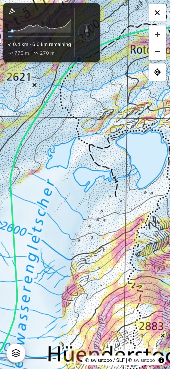
topo^alpin is your planning tool for alpine mountain tours. Draw your route directly on the map or upload a GPX file, analyse slope angles and elevation profiles, and navigate to the summit via GPS – all in one app.
Interactive maps:
- slopemap HD: custom base map and slope angle maps at 5 m resolution for the entire Alps
- Official topographic maps from swisstopo (CH), BEV (AT), LDBV (BY) and IGN (FR)
- Avalanche terrain classification ATES (AutoATES v2) for the Alps and SLF CAT/ATH
- Ski touring, snowshoe and hiking trails
- Wildlife and herd protection zones
- Offline maps: download map tiles in advance for areas without reception
Route planning:
- Draw your route on the map with automatic DEM elevation data
- Upload GPX files and analyse the elevation profile with slope angles
- Export drawn routes as GPX files
- GPS navigation to the summit or along your route
- Slope meter with live device sensor
- Compass rose, distance, elevation delta and progress indicator
- Dynamic Island and Lock Screen: remaining distance and elevation at a glance
Mountain weather:
- 6 weather models (ICON EU, ICON D2, AROME, ECMWF, GFS, AIFS) as a weighted ensemble
- 2-day weather summary with avalanche danger level at a glance
- 10-day overview and 48-hour detail view
- Thunderstorm risk, summit wind at various elevation levels
- Freezing level and cloud base
- Fresh snow (24h/72h/7d) from the nearest station – automatically during snow season
- Sunrise, sunset and daylight hours – elevation-corrected
- Weather warnings from MeteoAlarm for the Alpine region
- Real-time mountain weather stations from CH, AT, DE, IT and FR
Tour-Check:
- Risk assessment of your GPX tour with key-section markers directly in the elevation profile
- ATES avalanche terrain classification and terrain risk overlay along the whole tour
- Toggle in the elevation profile between Tour-Check and terrain risk
- Avalanche danger level fallback in Settings if no current bulletin is available
topo^alpin is a self-responsibility tool. It does not replace alpine experience or careful tour planning.
Accessibility
ipadiphonemacrealityDevicetvoswatch
Version history 8 versions
Build 886529051v1.23.02026-06-04 22:54:40
New: Tour-Check and avalanche terrain
Tour-Check rates your GPX tour: risk score, avalanche terrain (ATES) and key sections directly in the elevation profile.
- Avalanche terrain classification for the Alps
- Terrain risk overlay on the map
- Meteogram shows the past 3 days
- Weather warnings badge in the weather tab
Build 885580330v1.16.12026-05-12 19:27:58
New:
- Meteogram now shows the past 3 days – great for comparing how the weather was with what's coming
- Weather tab shows a badge when active weather warnings are in effect
Improved:
- Meteogram scroll position is preserved when switching between weather models
Build 885332497v1.15.32026-05-07 16:46:50
New:
- Dynamic Island: Live Activity shows remaining distance, elevation and progress during navigation – also on the Lock Screen
- Fresh snow: Current fresh snow depth (24h/72h/7d) from the nearest station – automatically during snow season
- Weather summary: 2-day forecast with weather icon, min/max temperature and avalanche danger level at a glance
- Sun times: Sunrise, sunset and daylight hours – elevation-corrected
- Thunderstorm risk: Thunderstorm score in meteogram detail with colour-coded warning
Build 883842896v1.5.02026-03-28 09:00:48
New Features:
- Tab navigation on iPhone — quickly switch between route, map and weather
- Resume drawn routes — tap the pencil and your markers are instantly restored
- Redesigned settings — clear tabs with icons, more space
Improvements & Fixes:
- Minimum elevation in nearby search up to 4000 m (for 3000+ m peaks)
- Settings sliders respond more precisely on touchscreen
Build 883675774v1.4.02026-03-25 00:07:27
- NEW: Offline maps — download map tiles along your GPX track and use them without internet
- Back-to-track button: quickly jump back to your route when you scroll away
- Wider terrain overlay opacity slider on mobile
Build 883553294v1.3.32026-03-20 00:11:07
- Navigation arrow now points correctly to the target (45° offset fixed)
- Stable navigation HUD width when distance values change
- Larger map buttons for better touch targets
- Slope meter: consistent sheet header style
Build 883131891v1.0.32026-03-19 07:42:50
Build 883535370v1.3.22026-03-19 12:06:02
- GPX export and import now work reliably on iOS (share sheet and file browser)
- Improved weather warning translations
- Legal pages now available in French and Italian
- New: Redesigned GPX route view – track name display, round-trip option, cleaner layout
- Compass and summit needle: Reliable recovery after switching apps
- Improved API security
- Settings: Improved slider responsiveness
- Settings reorganised: Clear tabs (General, Navigation, Search)
- New: Compass rose in navigation – shows heading direction in real time
- New: Slope meter – measure the incline directly on the slope using the device sensor
- Nearby search: Much faster and more reliable detection of nearby peaks and huts
- Elevation data: Dedicated elevation server for more precise terrain profiles
No pricing data captured yet — comparisons appear once the app has paid storefronts or in-app purchases.
Availability 1 of 1 storefronts
| Region | Language | Price | Ratings | Avg | Version |
|---|---|---|---|---|---|
| US | en-US | Free | 0 | — | 1.23.0 |
Change log 12 changes · US
✎
releaseNotes updated
New: Tour-Check and avalanche terrain
Tour-Check rates your GPX tour: risk score, avalanche terrain (ATES) and key sections directly in the elevation profile.
✎
description updated
topo^alpin is your planning tool for alpine mountain tours. Draw your route directly on the map or upload a GPX file, analyse slope angles and elevation profile
✎
subtitle updated
Tour Planning & Alpine Weather
✎
name updated
topo^alpin
◆
Version 1.23.0 released
New: Tour-Check and avalanche terrain
Tour-Check rates your GPX tour: risk score, avalanche terrain (ATES) and key sections directly in the elevation profile.
- Avalanche terrain classification for the Alps
- Terrain risk overlay on the m
◆
Version 1.16.1 released
New:
- Meteogram now shows the past 3 days – great for comparing how the weather was with what's coming
- Weather tab shows a badge when active weather warnings are in effect
Improved:
- Meteogram scroll position is preserved when switchin
◆
Version 1.15.3 released
New:
- Dynamic Island: Live Activity shows remaining distance, elevation and progress during navigation – also on the Lock Screen
- Fresh snow: Current fresh snow depth (24h/72h/7d) from the nearest station – automatically during snow seaso
◆
Version 1.5.0 released
New Features:
- Tab navigation on iPhone — quickly switch between route, map and weather
- Resume drawn routes — tap the pencil and your markers are instantly restored
- Redesigned settings — clear tabs with icons, more space
Improvements
◆
Version 1.4.0 released
- NEW: Offline maps — download map tiles along your GPX track and use them without internet
- Back-to-track button: quickly jump back to your route when you scroll away
- Wider terrain overlay opacity slider on mobile
◆
Version 1.3.3 released
- Navigation arrow now points correctly to the target (45° offset fixed)
- Stable navigation HUD width when distance values change
- Larger map buttons for better touch targets
- Slope meter: consistent sheet header style
◆
Version 1.3.2 released
- GPX export and import now work reliably on iOS (share sheet and file browser)
- Improved weather warning translations
- Legal pages now available in French and Italian
- New: Redesigned GPX route view – track name display, round-trip opti
◆
Version 1.0.3 released