Home › Photo & Video

 US
US
 ESes-ES
 ALen-GB
 ATde-DE
 AUen-AU
 BAen-GB
 BEen-GB
 BGen-GB
 BYen-GB
 CAen-CA
 CHde-CH
 CYen-GB
 CZen-GB
 DEde-DE
 DKen-GB
 EEen-GB
 FIen-GB
 FRfr-FR
 GBen-GB
 GRen-GB
 HRen-GB
 HUen-GB
 IEen-GB
 ISen-GB
 ITit
ITit LTen-GB
 LUen-GB
 LVen-GB
 MDen-GB
 MEen-GB
 MKen-GB
 MTen-GB
 NLnl
NLnl NOen-GB
 NZen-AU
 PLen-GB
 PTpt-PT
 ROen-GB
 RSen-GB
 RUru
RUru SEsv
SEsv SIen-GB
 SKen-GB
 TRen-GB
 UAen-GBUSen-US
 XKen-GB
46 of 46 storefronts
Content in en-US
Content in en-US
Information
Preview 2 platforms
iPhone 6 images
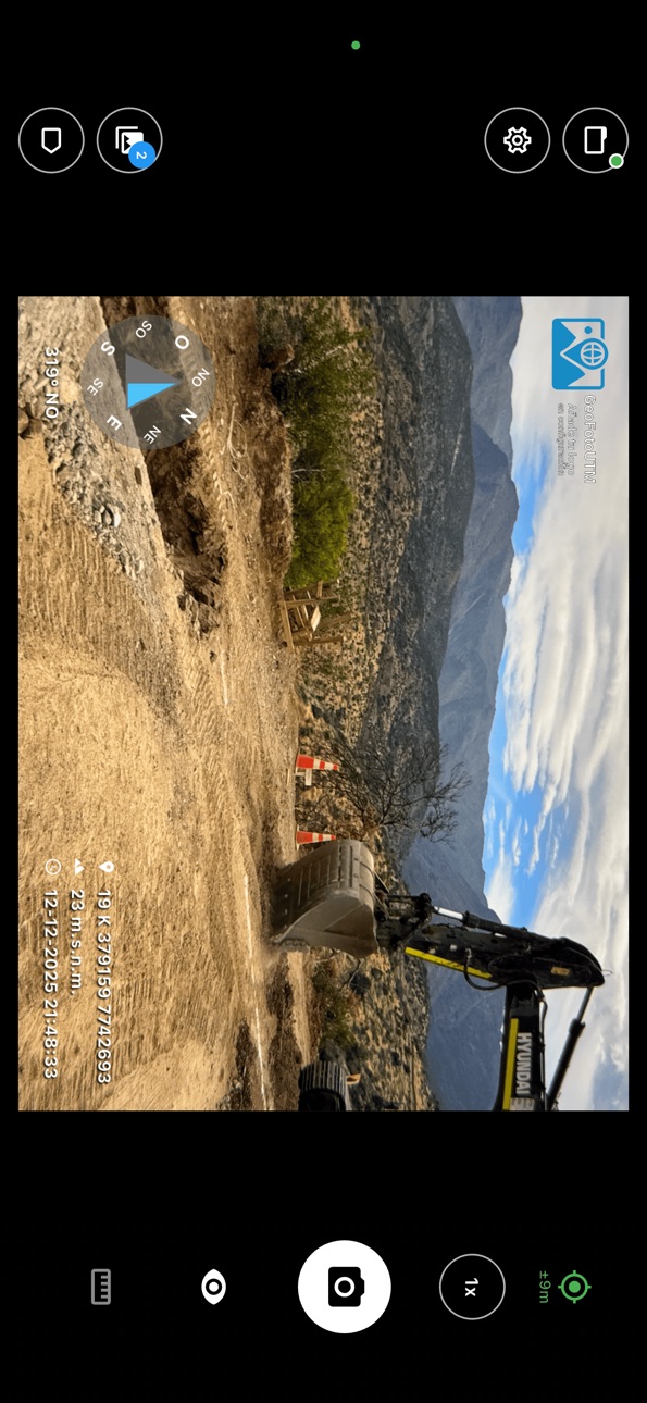


iPad 1 image

What’s New Version 1.6.1
• Fixed an issue when exporting to Google Earth (KMZ).
• Stability and performance improvements.
Description
GeoFotoUTM is designed for professionals working in the field in archaeology, paleontology, flora and fauna surveys, baselines, environmental impact assessments, soil studies, cadastre, and project monitoring.
The app allows you to take photos with complete geographic information integrated into the image metadata, ensuring consistency and traceability for use in reports and databases. If you require advanced customization, you can use our desktop app, also named GeoFotoUTM (available for macOS).
Each photo stores:
-GPS coordinates (latitude, longitude, altitude, and accuracy).
- Compass orientation (azimuth).
- Device tilt and orientation.
- Automatic conversion to UTM coordinates.
- EXIF metadata with associated geographic information.
Field Workflow
- Camera preview with real-time geospatial data.
- Configurable overlay on the image (text, coordinates, institution, or consultancy logo).
- Date and time stamp with time zone.
- Utilization of the device's focus and stabilization capabilities.
GeoFotoUTM aims to reduce manual post-processing work: coordinates, orientation, and altitude are already embedded in the photo, ready to be used in reports, field forms, or GIS systems.
Geospatial Data
- GPS reading with accuracy indicator.
- Calibratable compass with signal quality warning.
- 3D Orientation (pitch, roll, and heading of the device).
- Coordinates in decimal, DMS (degrees, minutes, seconds), and UTM (zone and hemisphere).
User Experience
- Interface designed for continuous outdoor use.
- Light and dark themes depending on lighting conditions.
- Configuration of what information is displayed on the screen.
- Adjustment of size and position of the overlaid information.
Use Cases
- Archaeology: Registration of sites, findings, and structures with exact coordinates and documented orientation.
- Paleontology: Documentation of findings, profiles, and stratigraphic contexts with precise location.
- Flora: Photographic record of plots, transects, species, and sampling points in the field.
- Fauna: Documentation of sightings, traps, camera traps, and monitoring points.
- Topography and Cadastre: Photographic support for surveys, boundary markings, and review of areas of interest.
- Geological and Biodiversity Studies: Documentation of sampling points, outcrops, stations, and routes.
Privacy and Permissions
GeoFoto UTM saves photos and their metadata solely on your device. We do not send or store your information on external servers.
Necessary permissions:
Camera: To take photos.
Location: To obtain GPS coordinates.
Storage: To save images.
Sensors (compass, accelerometer, and gyroscope): For device orientation and tilt.
Vibration: For haptic feedback.
Technical Requirements
iOS 16 or higher
GPS and magnetometer (compass).
Accelerometer and gyroscope for tilt data.
Best performance outdoors with a clear view of the sky.
Tips for Improving Accuracy
- Use the app outdoors with a clear view of the sky.
- Calibrate the compass occasionally from within the app.
- Wait for the GPS to reach reasonable accuracy before shooting.
- Keep the device away from metallic objects or magnets.
Supported Formats
Coordinates: Decimal, DMS (degrees-minutes-seconds), and UTM.
Images: JPEG with full EXIF metadata.
Reference System: WGS84 (GPS) with automatic conversion to UTM.
--------------------------------------
GeoFotoUTM helps you document your fieldwork with photos that already include the geographic information you need, without extra steps after shooting.
Accessibility
ipadiphonemacrealityDevicetvoswatch
Version history 16 versions
Build 887043888v1.6.12026-06-16 20:25:32
• Fixed an issue when exporting to Google Earth (KMZ).
• Stability and performance improvements.
Build 886648987v1.6.02026-06-08 00:49:08
What's New in Version 1.6.0
NEW LANGUAGE
• The app is now available in Portuguese, in addition to Spanish and English. The language follows your device automatically.
MORE ACCURATE ALTITUDE
• You can now choose how altitude is recorded: above sea level or exactly as reported by the device.
• Altitude above sea level better reflects the real terrain.
• When importing photos, you can set the matching altitude reference.
CLEARER PHOTO VERIFICATION
• If a photo can't be verified, the app clearly explains why (for example, a manually entered location or an unregistered device) and how to fix it.
• Easy recovery if your signing key stops being valid: you can generate a new one on the device.
• Verification keeps working offline and syncs automatically when the connection returns.
UPDATE ALERTS
• The app lets you know when a new version is published, so you always have the latest improvements.
IMPORT AND ORGANIZATION
• Step-by-step guided photo import: direction, altitude and date/time, with the option to apply the same data to the rest.
• Search for features (points, zones and routes) on the map.
• More options when restyling photos: show or hide the data box, coordinates, altitude and date/time.
STABILITY AND CLARITY
• Clearer, more helpful error messages (connection, files, iCloud photos, database).
• Improved GPS averaging behavior, with alerts when the signal isn't strong enough.
• Greater reliability when processing and saving photos.
Thank you for using GeoFoto UTM.
Build 884994532v1.5.22026-04-29 20:00:51
What's new in version 1.5.2
- Measure distances directly on the map between photos, points, or any location.
- Control which photos are visible on the map, including show/hide options by day.
- Manage polygons, points, and tracks from a unified screen with search, multi-select, and bulk actions.
- Export selected content more easily, with clearer choices for what to include.
- Improved sharing, KMZ/KML import and export, backup restore, and low-storage handling.
- Better camera and GPS reliability while sensors initialize.
- Stability and performance improvements across map rendering, database startup, and capture flows.
Build 884565636v1.5.12026-04-16 17:25:48
• Projection suggestions: the app detects your location and recommends the most accurate local coordinate system for your area.
• Improved file sharing: open .geofoto, .gpx, .kml, and other formats directly from other apps.
• More accurate compass: improved sensor calibration for more reliable heading readings.
• Tag context menu: select text in any descriptive field and quickly use it as a tag.
• Map marker clustering: nearby photos are automatically grouped for a cleaner view.
• General performance and stability improvements.
Build 883626551v1.5.02026-03-22 20:23:47
New
New photo verification with cryptographic signing, integrity validation, and external edit detection.
New backup and restore system with project selection, progress tracking, and cancellation support.
New tools for managing geographic points and tracks, including track analysis and improved organization in the map and gallery.
Improvements
Shared import now supports images, GPX routes, and KML/KMZ files with points and tracks.
The map adds custom markers, direction cones, and more display controls.
The camera is improved with multi-lens support, quick exposure control, and stronger low-storage and error handling.
General stability, performance, and error-handling improvements are included.
Build 882666599v1.4.52026-02-22 00:03:54
Bug fixes and stability improvements.
Build 882444024v1.4.32026-02-13 19:36:41
Photo metadata editing, project import/export (.geofoto), manual projected coordinate input and stability improvements.
Build 882083643v1.4.22026-02-02 23:26:22
NEW FEATURES:
• Photo Import: Import existing photos from your gallery. Automatically extracts GPS coordinates, date, and heading from EXIF metadata.
• Custom Projections: Define your own coordinate projections using PROJ strings for specialized mapping workflows.
• Advanced Gallery Filters: Filter photos by date range and tags for easier organization.
IMPROVEMENTS:
• Text alignment options for overlay elements
• Background and border styling for text and logo overlays
• Better memory handling for large photos
• Enhanced timezone handling for imported photos
Build 881514506v1.4.12026-01-16 14:52:16
What's New in this version:
• Critical Fix
- Fixed bug showing incorrect date/time on captured photos
• Advanced Polygon Customization
- Configurable stroke color and opacity
- Adjustable line width
- Independent fill color and opacity
• Improved Folder Management
- New option to delete folders with all contents
- Content preview before deletion
• Stability and performance improvements
Build 881330169v1.4.02026-01-08 22:35:31
WHAT'S NEW
Geographic Polygons
- Complete polygon management with organizational folders
- KML/KMZ file import with configurable options
- Support for multiple geometries and folder structures
- Multi-select for batch operations
- Progress indicator for imports
New Visual Design
- Redesigned interface with professional look
- New fonts for better readability
- Improved visual experience across all screens
Points and Routes
- New support for geographic points of interest
- Create and manage routes and lines
Photo Map
- View your geolocated photos on the map
- Variable resolution capture
Improved Performance
- Faster loading of large lists
- Smoother map display
- Reduced memory usage
Fixes
- Overall app stability improvements
- Improved GPS synchronization
- Better photo format compatibility
- More accurate area calculations for large polygons
- Expanded coordinate format support
Build 881026065v1.3.12025-12-27 00:55:18
What's new in 1.3.1:
• RESTYLE OVERLAYS
You can now change the style of your existing photos without retaking them. Adjust labels, logo, and format directly from the gallery.
• STANDALONE AZIMUTH
New option to display orientation (azimuth) as a separate element in the overlay, giving you more flexibility in data presentation.
• IMPROVED GALLERY
- New always-visible multi-select button
- Visual indicators on thumbnails during selection mode
- Restyle button directly in photo detail view
• TECHNICAL IMPROVEMENTS
- Optimized sensor service with better lifecycle management
- Overall app stability improvements
Build 880628130v1.3.02025-12-14 06:19:18
NEW COMPASS STYLES!
• 11 compass rose designs to choose from: from minimalist to professional detailed rose
• New styles: North Arrow, Circle Rose, Detailed Rose, Full Cardinals, Minimalist, Ring Cardinals and 8-Point
• Customize colors: primary, secondary, background and text for your compass
• Choose whether the rose rotates with heading or stays fixed
PROFESSIONAL CLASSIC COMPASS
• New full-screen compass with two rings: true north and magnetic north
• Built-in bubble level to check device horizontality
• Magnetic declination indicator
MORE UPDATES
• Template system (.geofoto): export and import your complete configuration including logo
• Stability and performance improvements
Build 880410920v1.2.12025-12-07 05:01:20
- Added multi-language support.
- Improved performance.
- Fixed capture bugs in some devices.
Build 880286114v1.22025-12-03 13:14:42
Novedades
- Exportación de proyectos a KMZ con fotos georreferenciadas.
- Ingreso manual de coordenadas GPS y selección de punto en mapa interactivo.
- Parser de coordenadas con soporte para DD, DMS, UTM, etc.
Mejoras
- Interfaz con rotación automática según orientación del dispositivo.
- Indicadores de pitch/roll más precisos.
- Pantalla de detalle de foto optimizada.
- Borrado de fotos directamente desde la galería.
- Servicio de sensores con mayor estabilidad y precisión.
Correcciones
- Mejoras generales de estabilidad e interfaz.
Build 880020557v1.12025-11-24 16:49:55
Novedades:
• Sistema de Proyectos y Etiquetas personalizadas
• Galería con visor EXIF completo
• Cámara: Modo GPS PRO (promediado), horizonte y enfoque mejorado
• Opciones flexibles para compartir fotos
Mejoras:
• Mayor estabilidad, velocidad de captura y corrección de orientación
• Interfaz renovada y optimización de memoria
• Corrección de errores y bugs varios
Build 879854285v1.02025-11-20 07:24:40
No pricing data captured yet — comparisons appear once the app has paid storefronts or in-app purchases.
Availability 46 of 46 storefronts
| Region | Language | Price | Ratings | Avg | Version |
|---|---|---|---|---|---|
| ES | es-ES | Free | 2 | 5.0 | 1.6.1 |
| AL | en-GB | Free | 0 | — | 1.6.1 |
| AT | de-DE | Free | 0 | — | 1.6.1 |
| AU | en-AU | Free | 0 | — | 1.6.1 |
| BA | en-GB | Free | 0 | — | 1.6.1 |
| BE | en-GB | Free | 0 | — | 1.6.1 |
| BG | en-GB | Free | 0 | — | 1.6.1 |
| BY | en-GB | Free | 0 | — | 1.6.1 |
| CA | en-CA | Free | 0 | — | 1.6.1 |
| CH | de-CH | Free | 0 | — | 1.6.1 |
| CY | en-GB | Free | 0 | — | 1.6.1 |
| CZ | en-GB | Free | 0 | — | 1.6.1 |
| DE | de-DE | Free | 0 | — | 1.6.1 |
| DK | en-GB | Free | 0 | — | 1.6.1 |
| EE | en-GB | Free | 0 | — | 1.6.1 |
| FI | en-GB | Free | 0 | — | 1.6.1 |
| FR | fr-FR | Free | 0 | — | 1.6.1 |
| GB | en-GB | Free | 0 | — | 1.6.1 |
| GR | en-GB | Free | 0 | — | 1.6.1 |
| HR | en-GB | Free | 0 | — | 1.6.1 |
| HU | en-GB | Free | 0 | — | 1.6.1 |
| IE | en-GB | Free | 0 | — | 1.6.1 |
| IS | en-GB | Free | 0 | — | 1.6.1 |
| IT | it | Free | 0 | — | 1.6.1 |
| LT | en-GB | Free | 0 | — | 1.6.1 |
| LU | en-GB | Free | 0 | — | 1.6.1 |
| LV | en-GB | Free | 0 | — | 1.6.1 |
| MD | en-GB | Free | 0 | — | 1.6.1 |
| ME | en-GB | Free | 0 | — | 1.6.1 |
| MK | en-GB | Free | 0 | — | 1.6.1 |
| MT | en-GB | Free | 0 | — | 1.6.1 |
| NL | nl | Free | 0 | — | 1.6.1 |
| NO | en-GB | Free | 0 | — | 1.6.1 |
| NZ | en-AU | Free | 0 | — | 1.6.1 |
| PL | en-GB | Free | 0 | — | 1.6.1 |
| PT | pt-PT | Free | 0 | — | 1.6.1 |
| RO | en-GB | Free | 0 | — | 1.6.1 |
| RS | en-GB | Free | 0 | — | 1.6.1 |
| RU | ru | Free | 0 | — | 1.6.1 |
| SE | sv | Free | 0 | — | 1.6.1 |
| SI | en-GB | Free | 0 | — | 1.6.1 |
| SK | en-GB | Free | 0 | — | 1.6.1 |
| TR | en-GB | Free | 0 | — | 1.6.1 |
| UA | en-GB | Free | 0 | — | 1.6.1 |
| US | en-US | Free | 0 | — | 1.6.1 |
| XK | en-GB | Free | 0 | — | 1.6.1 |
Change log 20 changes · US
✎
releaseNotes updated
• Fixed an issue when exporting to Google Earth (KMZ).
• Stability and performance improvements.
✎
description updated
GeoFotoUTM is designed for professionals working in the field in archaeology, paleontology, flora and fauna surveys, baselines, environmental impact assessments
✎
subtitle updated
Fotografías georreferenciadas
✎
name updated
GeoFotoUTM
◆
Version 1.6.1 released
• Fixed an issue when exporting to Google Earth (KMZ).
• Stability and performance improvements.
◆
Version 1.6.0 released
What's New in Version 1.6.0
NEW LANGUAGE
• The app is now available in Portuguese, in addition to Spanish and English. The language follows your device automatically.
MORE ACCURATE ALTITUDE
• You can now choose how altitude is recorded: a
◆
Version 1.5.2 released
What's new in version 1.5.2
- Measure distances directly on the map between photos, points, or any location.
- Control which photos are visible on the map, including show/hide options by day.
- Manage polygons, points, and tracks from a uni
◆
Version 1.5.1 released
• Projection suggestions: the app detects your location and recommends the most accurate local coordinate system for your area.
• Improved file sharing: open .geofoto, .gpx, .kml, and other formats directly from other apps.
• More accurate
◆
Version 1.5.0 released
New
New photo verification with cryptographic signing, integrity validation, and external edit detection.
New backup and restore system with project selection, progress tracking, and cancellation support.
New tools for managing geographic
◆
Version 1.4.5 released
Bug fixes and stability improvements.
◆
Version 1.4.3 released
Photo metadata editing, project import/export (.geofoto), manual projected coordinate input and stability improvements.
◆
Version 1.4.2 released
NEW FEATURES:
• Photo Import: Import existing photos from your gallery. Automatically extracts GPS coordinates, date, and heading from EXIF metadata.
• Custom Projections: Define your own coordinate projections using PROJ strings for specia
◆
Version 1.4.1 released
What's New in this version:
• Critical Fix
- Fixed bug showing incorrect date/time on captured photos
• Advanced Polygon Customization
- Configurable stroke color and opacity
- Adjustable line width
- Independent fill color and op
◆
Version 1.4.0 released
WHAT'S NEW
Geographic Polygons
- Complete polygon management with organizational folders
- KML/KMZ file import with configurable options
- Support for multiple geometries and folder structures
- Multi-select for batch operations
- Progress
◆
Version 1.3.1 released
What's new in 1.3.1:
• RESTYLE OVERLAYS
You can now change the style of your existing photos without retaking them. Adjust labels, logo, and format directly from the gallery.
• STANDALONE AZIMUTH
New option to display orientation (azimuth
◆
Version 1.3.0 released
NEW COMPASS STYLES!
• 11 compass rose designs to choose from: from minimalist to professional detailed rose
• New styles: North Arrow, Circle Rose, Detailed Rose, Full Cardinals, Minimalist, Ring Cardinals and 8-Point
• Customize colors: pr
◆
Version 1.2.1 released
- Added multi-language support.
- Improved performance.
- Fixed capture bugs in some devices.
◆
Version 1.2 released
Novedades
- Exportación de proyectos a KMZ con fotos georreferenciadas.
- Ingreso manual de coordenadas GPS y selección de punto en mapa interactivo.
- Parser de coordenadas con soporte para DD, DMS, UTM, etc.
Mejoras
- Interfaz con rotaci
◆
Version 1.1 released
Novedades:
• Sistema de Proyectos y Etiquetas personalizadas
• Galería con visor EXIF completo
• Cámara: Modo GPS PRO (promediado), horizonte y enfoque mejorado
• Opciones flexibles para compartir fotos
Mejoras:
• Mayor estabilidad, veloci
◆
Version 1.0 released