Home › Navigation

 US
US
1 of 1 storefronts
Content in en-US
Content in en-US
Information
Preview 1 platform
iPhone 6 images




What’s New Version 2.6.10
- Improved Compass Mode and map orientation controls
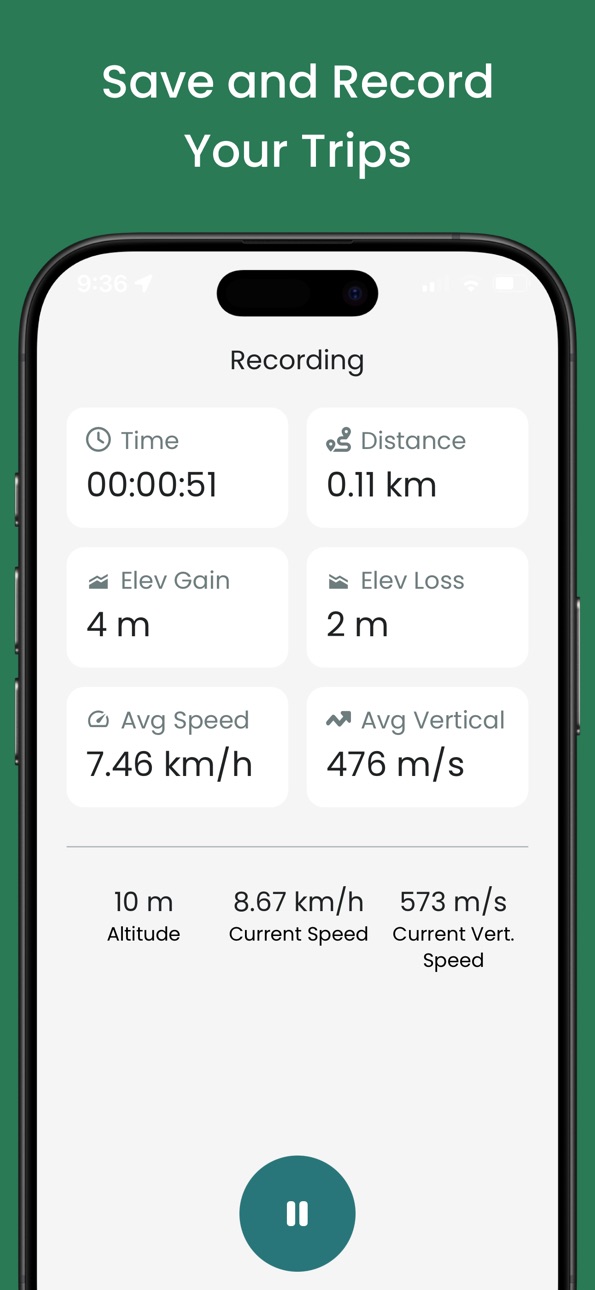
- Activity stats now include elevation loss, highest, and lowest point even offline
- More reliable trip report photo uploads
- Numerous small improvements and fixes throughout the app
Description
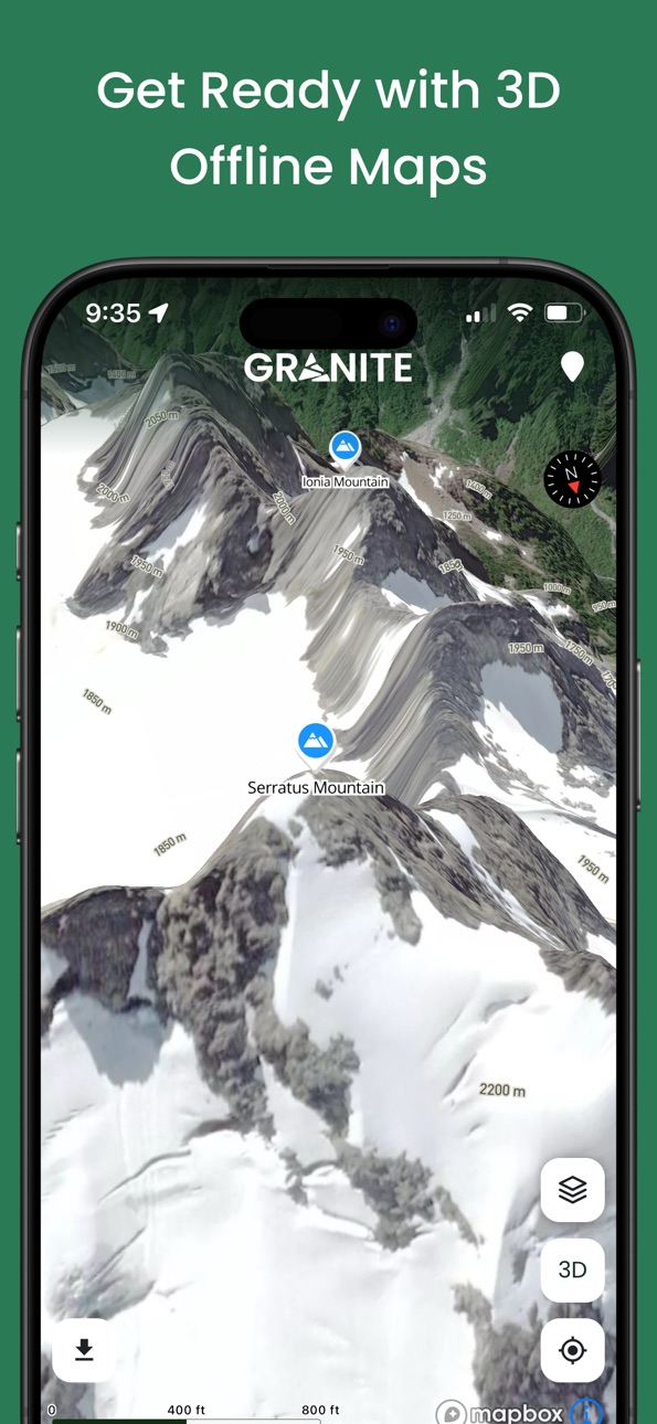
Discover Granite, the mountain app for planning, navigating, tracking, and sharing better days outside.
Explore detailed maps, find new objectives, follow recent trip reports, and discover routes shaped by local guides, experts, and mountain communities.
• Navigate Offline: Access detailed maps, terrain layers, and topographic information even when you are out of service. Download what you need before heading out and stay oriented wherever the day takes you.
• Plan With Confidence: Check useful mountain information before you go, including avalanche forecasts, wildfire and smoke conditions, and road status where available. Draw your own routes, see distance and elevation as you go, and get time estimates for the day ahead.
• Discover Local Routes: Explore curated routes and collections created with local guides, experienced contributors, and mountain communities. Find practical route details, seasonal information, and local knowledge from people who know the terrain.
• Track Your Activities: Record hikes, ski tours, climbs, trail runs, rides, and more. Sync with Garmin and Strava to automatically save key stats and GPX tracks, even when your phone stays in your pack.
• Follow Your Progress: See your mountain story grow through completed peaks, personal heatmaps, activity history, and detailed adventure stats.
• Share What You Find: Write trip reports, share current conditions and useful insights, and discover new objectives through the experiences of other mountain people.
Built in Squamish for people who love getting outside.
Hike, climb, ski, and explore with Granite.
Subject to Apple's standard end user license agreement (EULA):
https://www.apple.com/legal/internet-services/itunes/dev/stdeula/
In-App Purchases US pricing
Pro Subscription
Yearly 14-day free trial$38.99
Capabilities
In-App Purchases
Accessibility
ipadiphonemacrealityDevicetvoswatch
Version history 25 versions
Build 887908762v2.6.102026-07-06 22:32:49
- Improved Compass Mode and map orientation controls
- Activity stats now include elevation loss, highest, and lowest point even offline
- More reliable trip report photo uploads
- Numerous small improvements and fixes throughout the app
Build 887102427v2.6.92026-06-17 21:19:27
- New Fire & Smoke layer with live wildfires, fire perimeters, and smoke forecast
- New Compass Mode rotates the map with your heading
- Improved route drawing with Out and Back and Reverse tools
- Create waypoints from coordinates or save searched places with one tap
Build 886844459v2.6.82026-06-12 01:39:25
- Save GPS tracks from trip reports directly to My Content
- More accurate elevation profiles and route statistics for curated routes
- Small improvements throughout the app
Build 886586220v2.6.72026-06-07 18:19:56
- Explore routes by activity type with dedicated Hiking, Mountaineering, Skiing, MTB, and Ice Climbing map layers
- Improved trail visibility on Satellite and Winter maps
- Munter estimates now include your typical break times for more realistic trip planning
- More reliable activity selection when routes overlap trails
- Various small improvements and fixes throughout the app
Build 886208316v2.6.52026-05-27 20:35:41
- Find curated routes faster, now organized by sport and what's near you.
- Search routes by name
- Get richer trip beta on curated route, from terrain and hazards to parking and water
- A cleaner, easier-to-read route layout
- Tap photos on trip report maps to view them full-screen
- Plus polish and bug fixes
Build 885162758v2.6.22026-05-01 19:20:39
- Recalculate elevation when drawing routes, available manually and automatically on save
Build 884955971v2.6.12026-04-27 20:31:31
- Improved trail network and trail interactivity
- Snap to trail
Build 883984764v2.5.22026-04-01 04:21:41
- Curated routes now include segments, allowing each section of the route to be described in more detail
Build 883519485v2.5.02026-03-19 00:38:28
- Improved app reliability for a smoother experience
Build 882917820v2.4.52026-03-15 16:12:25
• Public profiles accessible by tapping user avatars
• GPX export for personal routes, waypoints, and folders
• New privacy settings for activities and heatmap contribution
• Strava compliance update
• Offline maps improvements and more accurate downloads
• Backroad Status with interactive road conditions
• Persistent terrain layer between app restarts
• Smoother elevation profiles for imported GPX
• Fix session timeout issue
• Other minor improvements and bug fixes
Build 882586193v2.4.22026-02-19 02:27:45
- Fix recording issues
- Expanded terrain layers to Alaska, Appalachians, Sierra Nevada, and Scandinavia.
Build 882492154v2.4.12026-02-16 00:55:13
- Search through trip reports
- Map now opens where you left
- Fix Personal route descriptions not always saving
- And many other fixes
Build 882242044v2.4.02026-02-07 01:55:42
Lot of new features in this release.
- New terrain layer to show elevations.
- Expanded terrain layers across Canada, Pacific Northwest, European Alps and Japan.
- Redesigned layer menu and improved map UI
- New compass heading tool available in map settings
- Estimated travel time when drawing routes based on your own activity data
As well as many other improvements
- Recorded activities on the map are now interactive
- Improved satellite contour visibility with refined low and high settings
- Folder selection when creating routes and waypoints
- Save descriptions when drawing routes and waypoints
- App now available on iOS 16
Build 881368383v2.3.12026-01-10 23:14:16
- Optimized waypoints selection and clustering.
- Improved terrain layer opacity and contour lines on satellite.
- Added color options to multi-routes imports.
- Multiple bug fixes with trip reports and other.
Build 881299679v2.3.02026-01-08 07:59:08
New map layers
- Terrain closures for Whistler Resort and Avalanche Canada restricted zones
- ATES layer with terrain ratings, avalanche paths and decision points
- Improved Avalanche Canada forecast
Unsynced recorded activities now appear on the map when offline
More bug fixes & polish
Build 881231383v2.2.52026-01-06 19:23:31
- Improved trip report editor with smarter linking, region selection, and faster loading
- Profile prompts now encourage adding a name and photo before sharing
Build 880779074v2.2.42025-12-17 22:41:43
- Refreshed the community feed to make trip reports more engaging.
- New reactions, improved comment system and interactive cards
- Minor fixes
Build 880570651v2.2.12025-12-12 02:16:46
- Enhanced photo viewing with zoom, pan, focus mode, and swipe to dismiss
- Clear safety acknowledgment when opening curated routes for the first time
- Improved reliability of GPX and file imports with minor bug fixes
- New loading states for curated routes and collections
Build 880285952v2.2.02025-12-03 01:56:07
- Now support KML, TCX and GPX for imports
- Import multiple routes and waypoints in one step directly into a folder
- Minor fixes including more accurate elevation data
Build 880116299v2.1.12025-11-26 21:12:01
- A new map setting letting you place a center marker to see distance from you and elevation at that point
- Minor fixes
Build 880055153v2.1.02025-11-25 12:52:37
- New folder system for personal routes and waypoints
- Minor fixes
Build 879758257v2.0.52025-11-14 05:14:07
- Extended map configs (includes: terrain layer opacity, contour on sat, distance grid)
- Routes (summer, winter, MTB) can be disabled
Build 879687257v2.0.42025-11-12 00:56:22
Explore trip reports and collections by regions.
Comment on a trip report directly on the feed.
New toggle to download winter satellite offline.
Faster search on map and better peak browsing.
Build 879470997v2.0.22025-11-04 05:46:51
Fixed Strava not connecting on iOS.
Fixed elevation calculations when using 2D maps.
Build 879379408v2.0.12025-10-31 19:36:28
Granite 2.0 is out and include a suite of new features.
- Guidebook quality collections from local guides and experts
- Winter and Summer map modes to see all relevant routes.
- Avalanche Canada forecasts
- Onboarding flow for new users
- Record your activities directly in the app
Price history by region
Currency
Show
Columns
Search
Availability 1 of 1 storefronts
| Region | Language | Price | Ratings | Avg | Version |
|---|---|---|---|---|---|
| US | en-US | Free | 0 | — | 2.6.10 |
Change log 29 changes · US
✎
releaseNotes updated
- Improved Compass Mode and map orientation controls
- Activity stats now include elevation loss, highest, and lowest point even offline
- More reliable trip re
✎
description updated
Discover Granite, the mountain app for planning, navigating, tracking, and sharing better days outside.
Explore detailed maps, find new objectives, follow rece
✎
subtitle updated
3D Maps for Hike, Ski, Climb
✎
name updated
Granite - Built for Mountains
◆
Version 2.6.10 released
- Improved Compass Mode and map orientation controls
- Activity stats now include elevation loss, highest, and lowest point even offline
- More reliable trip report photo uploads
- Numerous small improvements and fixes throughout the app
◆
Version 2.6.9 released
- New Fire & Smoke layer with live wildfires, fire perimeters, and smoke forecast
- New Compass Mode rotates the map with your heading
- Improved route drawing with Out and Back and Reverse tools
- Create waypoints from coordinates or save
◆
Version 2.6.8 released
- Save GPS tracks from trip reports directly to My Content
- More accurate elevation profiles and route statistics for curated routes
- Small improvements throughout the app
◆
Version 2.6.7 released
- Explore routes by activity type with dedicated Hiking, Mountaineering, Skiing, MTB, and Ice Climbing map layers
- Improved trail visibility on Satellite and Winter maps
- Munter estimates now include your typical break times for more real
◆
Version 2.6.5 released
- Find curated routes faster, now organized by sport and what's near you.
- Search routes by name
- Get richer trip beta on curated route, from terrain and hazards to parking and water
- A cleaner, easier-to-read route layout
- Tap photos o
◆
Version 2.6.2 released
- Recalculate elevation when drawing routes, available manually and automatically on save
◆
Version 2.6.1 released
- Improved trail network and trail interactivity
- Snap to trail
◆
Version 2.5.2 released
- Curated routes now include segments, allowing each section of the route to be described in more detail
◆
Version 2.5.0 released
- Improved app reliability for a smoother experience
◆
Version 2.4.5 released
• Public profiles accessible by tapping user avatars
• GPX export for personal routes, waypoints, and folders
• New privacy settings for activities and heatmap contribution
• Strava compliance update
• Offline maps improvements and more acc
◆
Version 2.4.2 released
- Fix recording issues
- Expanded terrain layers to Alaska, Appalachians, Sierra Nevada, and Scandinavia.
◆
Version 2.4.1 released
- Search through trip reports
- Map now opens where you left
- Fix Personal route descriptions not always saving
- And many other fixes
◆
Version 2.4.0 released
Lot of new features in this release.
- New terrain layer to show elevations.
- Expanded terrain layers across Canada, Pacific Northwest, European Alps and Japan.
- Redesigned layer menu and improved map UI
- New compass heading tool availab
◆
Version 2.3.1 released
- Optimized waypoints selection and clustering.
- Improved terrain layer opacity and contour lines on satellite.
- Added color options to multi-routes imports.
- Multiple bug fixes with trip reports and other.
◆
Version 2.3.0 released
New map layers
- Terrain closures for Whistler Resort and Avalanche Canada restricted zones
- ATES layer with terrain ratings, avalanche paths and decision points
- Improved Avalanche Canada forecast
Unsynced recorded activities now appear
◆
Version 2.2.5 released
- Improved trip report editor with smarter linking, region selection, and faster loading
- Profile prompts now encourage adding a name and photo before sharing
◆
Version 2.2.4 released
- Refreshed the community feed to make trip reports more engaging.
- New reactions, improved comment system and interactive cards
- Minor fixes
◆
Version 2.2.1 released
- Enhanced photo viewing with zoom, pan, focus mode, and swipe to dismiss
- Clear safety acknowledgment when opening curated routes for the first time
- Improved reliability of GPX and file imports with minor bug fixes
- New loading states
◆
Version 2.2.0 released
- Now support KML, TCX and GPX for imports
- Import multiple routes and waypoints in one step directly into a folder
- Minor fixes including more accurate elevation data
◆
Version 2.1.1 released
- A new map setting letting you place a center marker to see distance from you and elevation at that point
- Minor fixes
◆
Version 2.1.0 released
- New folder system for personal routes and waypoints
- Minor fixes
◆
Version 2.0.5 released
- Extended map configs (includes: terrain layer opacity, contour on sat, distance grid)
- Routes (summer, winter, MTB) can be disabled
◆
Version 2.0.4 released
Explore trip reports and collections by regions.
Comment on a trip report directly on the feed.
New toggle to download winter satellite offline.
Faster search on map and better peak browsing.
◆
Version 2.0.2 released
Fixed Strava not connecting on iOS.
Fixed elevation calculations when using 2D maps.
◆
Version 2.0.1 released
Granite 2.0 is out and include a suite of new features.
- Guidebook quality collections from local guides and experts
- Winter and Summer map modes to see all relevant routes.
- Avalanche Canada forecasts
- Onboarding flow for new users
- R