Home › Weather

 US
US
1 of 1 storefronts
Content in en-US
Content in en-US
Information
Preview 2 platforms
iPhone 10 images


iPad 9 images




What’s New Version 1.5.1
Updates to map layouts and UX improvements.
Description
Saltwater fishing and boating companion. Sea Surface Temps, Chlorophyll, Ocean conditions.
MARINE CONDITIONS - For Saltwater fishing and Boating
• Wave Forecaset Model
• NOAA Ocean Forecasts - Stay informed about weather and water conditions
• Sea Surface Temp (SST), Chlorophyll for water clarity and color
• Water Currents and Clarity
• Real-time Tide Information - Know when to fish with accurate tide data
• Sun & Moon Phases - Track how lunar cycles affect fish activity
• Shipwreck maps and details and depths
SALTWATER FISHING TOOLS
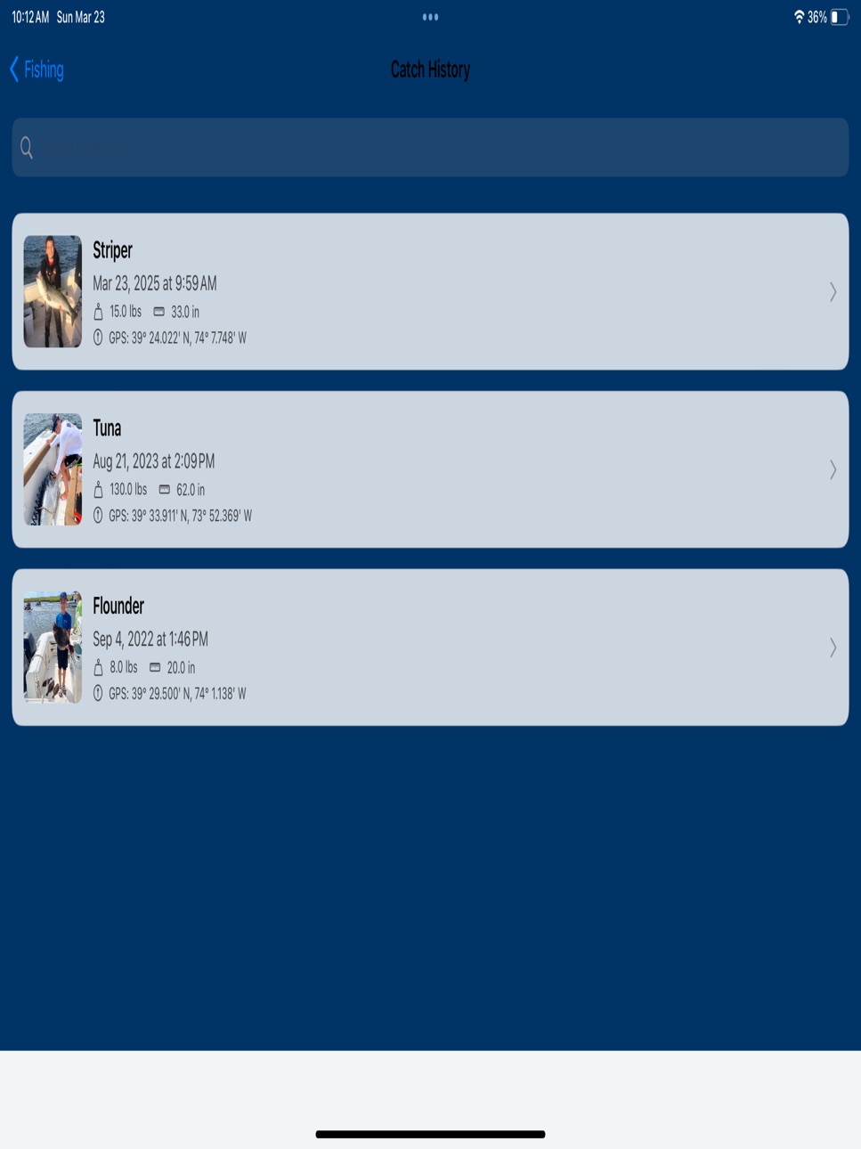
• Complete Fishing Catch Logs - Record species, weight, length, and location with photos
• Personal Best Tracking - Mark and celebrate your trophy catches
• Fishing Mapping - See where you've had success in the past
• Fishing Planner - Log your successful techniques, bait, and fishing conditions
BOATING ESSENTIALS
• USCG Notices - Stay informed about important safety notices
• Trip & Fuel Logging - Track your boat's performance and fuel usage
• Sandbar Checklist - Essential preparation for sandbar excursions
• Boating Safety List - Never forget critical safety equipment
VESSEL MANAGEMENT
• Boat Location Tracking - Always know where your vessel is located
• Boat Details Management - Keep all your vessel information organized
• Service Tracking - Stay on top of maintenance schedules
Perfect for weekend anglers and serious saltwater fishermen alike, SaltWater Scout helps you fish smarter, stay safer, and enjoy your time on the water with confidence.
Download today and transform your saltwater fishing experience!
Accessibility
ipadiphonemacrealityDevicetvoswatch
Version history 25 versions
Build 887703776v1.5.12026-07-02 00:02:31
Updates to map layouts and UX improvements.
Build 886501375v1.5.02026-06-04 16:14:19
Added bottom water temp.
Build 885879712v1.4.422026-05-20 00:35:31
Detailed bathymetric overlays.
Moved overlay details to bottom panel.
Minor bug fixes.
Build 884614359v1.4.412026-04-17 20:16:14
Update to the shipwreck maps for better performance.
Build 884208146v1.4.402026-04-07 15:12:34
Added waypoint management to the hourly SST maps.
Adjusted where the pop up for waypoints is shown.
Build 883523702v1.4.392026-03-19 18:49:59
Updates to the menus and spacing for more screen area.
Build 883319503v1.4.382026-03-13 17:14:01
Bug fix for SST in NZ.
Build 883033663v1.4.372026-03-05 01:31:22
Minor performance updates.
Build 882804203v1.4.362026-02-26 19:41:16
Minor update for GPX files.
Build 882523312v1.4.352026-02-17 01:14:10
GPX export bug fix.
Build 882423003v1.4.342026-02-13 22:36:19
Updated maps and added a waypoint management section.
Build 882205703v1.4.332026-02-05 23:24:39
Updated SDK for iOS 26.
Build 881814659v1.4.322026-01-27 04:14:37
Minor bug fixes.
Build 881619626v1.4.302026-01-19 06:19:01
Updated regions.
Build 881385079v1.4.292026-01-11 23:33:37
Removed temp legend from SST review.
Build 881043569v1.4.282025-12-28 07:59:36
Wave Map updated.
Build 880255670v1.4.262025-12-02 17:35:10
Fixed layout issue on smaller phones for drop down menus.
Build 880286148v1.4.272025-12-02 23:07:48
Addressed a menu issue on iPhone SE.
Build 878409602v1.4.252025-09-25 23:36:23
Minor bug fix.
Build 878279838v1.4.242025-09-20 04:55:35
Currents have been added
Tides now include stations with water temp and predictions where available
NOAA data added into the wave watch 3 graphs and table added.
Build 877887301v1.4.232025-09-08 09:41:02
Minor updates to the tides.
Build 877709979v1.4.222025-09-01 04:36:45
Chlorophyll adjustable range and other regions added.
Build 877204524v1.4.202025-08-13 09:45:01
Water Clarity added (kd490) with bathymetric lines
Ocean Altimetry added with bathymetric lines
Water temp range was increased to 95F
Spain, England and Ireland regions have been added
Minor Bug fixes
Build 877220814v1.4.212025-08-13 23:23:05
Addressed a bug in water clarity.
Build 876678311v1.4.192025-07-25 01:55:29
Added wave details to wreck details.
Added distance from inlet to the wavewatch map.
Fixed a clustering and performance issues in ship wrecks.
No pricing data captured yet — comparisons appear once the app has paid storefronts or in-app purchases.
Availability 1 of 1 storefronts
| Region | Language | Price | Ratings | Avg | Version |
|---|---|---|---|---|---|
| US | en-US | Free | 82 | 4.8 | 1.5.1 |
Change log 29 changes · US
✎
releaseNotes updated
Updates to map layouts and UX improvements.
✎
description updated
Saltwater fishing and boating companion. Sea Surface Temps, Chlorophyll, Ocean conditions.
MARINE CONDITIONS - For Saltwater fishing and Boating
• Wave Forec
✎
subtitle updated
Boating Fishing Tides Wave SST
✎
name updated
SaltWater Scout - Fishing
◆
Version 1.5.1 released
Updates to map layouts and UX improvements.
◆
Version 1.5.0 released
Added bottom water temp.
◆
Version 1.4.42 released
Detailed bathymetric overlays.
Moved overlay details to bottom panel.
Minor bug fixes.
◆
Version 1.4.41 released
Update to the shipwreck maps for better performance.
◆
Version 1.4.40 released
Added waypoint management to the hourly SST maps.
Adjusted where the pop up for waypoints is shown.
◆
Version 1.4.39 released
Updates to the menus and spacing for more screen area.
◆
Version 1.4.38 released
Bug fix for SST in NZ.
◆
Version 1.4.37 released
Minor performance updates.
◆
Version 1.4.36 released
Minor update for GPX files.
◆
Version 1.4.35 released
GPX export bug fix.
◆
Version 1.4.34 released
Updated maps and added a waypoint management section.
◆
Version 1.4.33 released
Updated SDK for iOS 26.
◆
Version 1.4.32 released
Minor bug fixes.
◆
Version 1.4.30 released
Updated regions.
◆
Version 1.4.29 released
Removed temp legend from SST review.
◆
Version 1.4.28 released
Wave Map updated.
◆
Version 1.4.27 released
Addressed a menu issue on iPhone SE.
◆
Version 1.4.26 released
Fixed layout issue on smaller phones for drop down menus.
◆
Version 1.4.25 released
Minor bug fix.
◆
Version 1.4.24 released
Currents have been added
Tides now include stations with water temp and predictions where available
NOAA data added into the wave watch 3 graphs and table added.
◆
Version 1.4.23 released
Minor updates to the tides.
◆
Version 1.4.22 released
Chlorophyll adjustable range and other regions added.
◆
Version 1.4.21 released
Addressed a bug in water clarity.
◆
Version 1.4.20 released
Water Clarity added (kd490) with bathymetric lines
Ocean Altimetry added with bathymetric lines
Water temp range was increased to 95F
Spain, England and Ireland regions have been added
Minor Bug fixes
◆
Version 1.4.19 released
Added wave details to wreck details.
Added distance from inlet to the wavewatch map.
Fixed a clustering and performance issues in ship wrecks.