Home › Sports

Information
Preview 2 platforms
iPhone 10 images



iPad 5 images


What’s New Version 3.5.0
Watch your spots for the conditions you want, get a heads-up the moment fresh data lands, and look back on your whole season.
New
• Watch a spot. Pick a condition like water temperature, current, or a temperature break, and we'll notify you when a spot hits it. All your watches live in one list.
• New data alerts. Get a push the moment fresh ocean data lands over your region, then tap it to jump straight to that layer on the map.
• Season story. Your Logbook now tells the story of your season, your trips, your water, and your catches in one recap.
• Overlay Sets. Save the layers you reach for as a named set, and load them back with one tap.
Improvements
• Faster playback. Replaying a recorded trip and dragging the timeline stays smooth, even on your longest days on the water.
• Charts. A cleaner, consistent look across every readout, with clearer axis labels and a current-direction arrow.
• AIS. Vessels stay readable when they crowd together, and your AIS toggle stays put across launches.
• Share. The Share Map sheet is simpler and keeps the details that matter.
Bug Fixes
• Fixed a crash when tapping a notification from the lock screen.
• Trips no longer get stuck backing up after their ocean conditions finish loading.
• Map controls no longer get stranded after closing a panel or returning to the app.
• A waypoint you just dropped can't be lost before it syncs to the cloud.
Description
Build your offshore map.
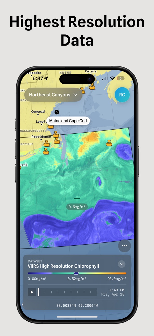
Stack sea surface temperature, chlorophyll, currents, and eddies; all in one view. Refine the range and colors to see exactly what matters. Track conditions at your spots over time. Share live maps with your crew.
Built for pros. Designed for everyone.
STACK YOUR LAYERS
One dataset tells part of the story. Stack them to see the complete picture. SST with currents. Chlorophyll with eddies. Your call.
REFINE YOUR VIEW
Dial in temperature ranges. Adjust color scales. Highlight the breaks that matter to you—not some default a developer picked.
TRACK YOUR SPOTS
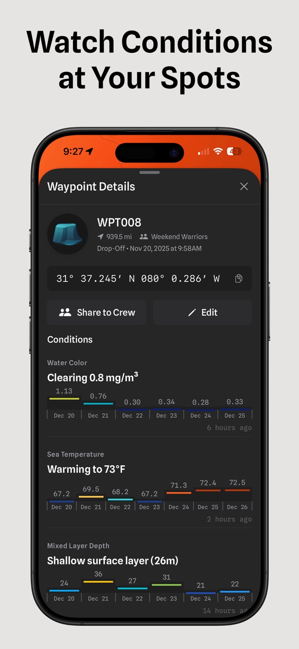
Drop a waypoint. Watch SST, chlorophyll, and mixed layer depth change over days. Know if conditions are building or fading before you run.
SHARE WITH YOUR CREW
Send a live map link—not a screenshot. Your crew sees exactly what you see. Same view. Same data. Same plan.
FRESH DATA, ALWAYS
Track satellite passes in real time. Know exactly when new imagery arrives for your region. Single-pass clarity when it counts.
ONE PLATFORM. YOUR WAY.
Salty isn't a map. It's a platform to build your map, track your water, and plan with your crew.
Download now. Start your trial. Build your first map and plan your next trip and have data to review it after.
Terms of Use (EULA): https://www.apple.com/legal/internet-services/itunes/dev/stdeula/
Privacy Policy: https://saltyoffshore.com/privacy
In-App Purchases US pricing
AIS Vessel Tracking Subscription
AIS Vessels · Monthly$9.99
Salty Pro Subscription
(Annual) · Yearly 7-day free trial$199.99
Elite Annual · Yearly 7-day free trial$500.00
Monthly · Monthly 7-day free trial$24.99
Basic Annual · Yearly 7-day free trial$99.99
Salty Basic Monthly · Monthly 7-day free trial$14.99
Capabilities
In-App Purchases
Accessibility
ipadiphonemacrealityDevicetvoswatch
Version history 25 versions
Build 887663596v3.5.02026-07-04 16:10:49
Watch your spots for the conditions you want, get a heads-up the moment fresh data lands, and look back on your whole season.
New
• Watch a spot. Pick a condition like water temperature, current, or a temperature break, and we'll notify you when a spot hits it. All your watches live in one list.
• New data alerts. Get a push the moment fresh ocean data lands over your region, then tap it to jump straight to that layer on the map.
• Season story. Your Logbook now tells the story of your season, your trips, your water, and your catches in one recap.
• Overlay Sets. Save the layers you reach for as a named set, and load them back with one tap.
Improvements
• Faster playback. Replaying a recorded trip and dragging the timeline stays smooth, even on your longest days on the water.
• Charts. A cleaner, consistent look across every readout, with clearer axis labels and a current-direction arrow.
• AIS. Vessels stay readable when they crowd together, and your AIS toggle stays put across launches.
• Share. The Share Map sheet is simpler and keeps the details that matter.
Bug Fixes
• Fixed a crash when tapping a notification from the lock screen.
• Trips no longer get stuck backing up after their ocean conditions finish loading.
• Map controls no longer get stranded after closing a panel or returning to the app.
• A waypoint you just dropped can't be lost before it syncs to the cloud.
Build 887526447v3.4.72026-06-27 16:35:15
This update fixes one bug ahead of tournaments this weekend. After a fresh install, the app didn't ask for location access, so your boat's position never showed on the map and distance tools didn't work. Location now works as soon as you install.
Build 887350299v3.4.62026-06-26 22:06:01
Lighter on your device, sharper trip-share posters, and reliable offline opens.
Improvements
• Trip Share — fresh art-first templates, swipeable, full-bleed photo, big species row.
• Backfill — stay in add-mode after each drop, so you can place several pins in one pass.
• Offline — your downloaded region opens instantly from cache, even when the launch network read fails.
• Layers — overlay categories regrouped by what captains actually reach for.
• Nav chart — symbol labels sit above land; buoy names appear only at the zoom they're readable.
• Waypoints — a focused track always shows its pins, and the pin layer rebuilds the moment waypoints change.
Bug Fixes
• Fixed a problem where panning the map could write large amounts of data to your device. Salty is now much lighter on storage.
• Trip share still renders when a photo fails to load, instead of failing silently.
• Render-stats overlay is off by default.
• Waypoint pin layers stay in sync on add and edit.
Build 887314593v3.4.42026-06-23 17:51:34
Steadier timeline controls and a wider view of the water.
Improvements
• Zoom out further to take in more of the map at once
Bug Fixes
• Timeline controls no longer disappear when you switch regions
• The overlay day picker no longer flickers or sticks on the wrong day
Build 887285957v3.4.32026-06-22 21:24:30
A faster, smoother map and more reliable trips on the water.
Improvements
• Smoother map with faster panning and zooming, even with lots of waypoints and tracks on screen
• Bolder, easier-to-follow track lines with a tapered wake
• Browse your trips as a gallery or a list
• Pick which datasets and days to download for offline use
• Trips finish right away without freezing, with a clear saving status
• Cloud sync pulls only new or changed trips, so it runs faster
Bug Fixes
• Map overlays no longer disappear when fully zoomed in
• Offline downloads stop right away when you cancel
• Your subscription no longer briefly shows free after you sign in
• Region data refreshes correctly
• My Location recenters the map again
Build 887171097v3.4.22026-06-19 14:14:28
Smoother offline downloads, smarter tracks, and fixes that keep your phone cooler on the water.
Improvements
• Finished trips get automatic names from your track data
• Waypoint ocean conditions work anywhere — no region lock
• Offline downloads start clean — existing data is cleared before a fresh download
• Map runs cooler with bathymetry and shaded relief no longer stacked at once
• GPS adapts power for battery and heat — heading sensor only when you need it
• Live Activity trip timer uses less battery — no more per-second widget updates
• Settings screens use clearer menus and consistent layout
• AIS vessel labels are more compact on the map
Bug Fixes
• Fixed a crash some captains hit opening the toolbar or station details
• Shared map links open the correct dataset
• Track detail updates live as ocean backfill completes
• Offline data downloads and loads reliably
• Offline day picker works again
• Backfill prompt no longer appears when you're offline
• Announcement sheets show and dismiss correctly
• Live Activity no longer keeps restoring after you dismiss it
Build 887063214v3.4.12026-06-17 17:51:58
Polish for your tracks, the measure tool, and waypoint coordinates — plus more reliable trip recording and sign-in.
New Features
• Resume or save a trip if recording was interrupted when the app closed
Improvements
• Tracks now open to one screen — chart, scrubber, and trip stats together
• Track names show as a clean capsule label on the map
• Smoother boat during playback, plus a live trail as you record
• Lock the map north-up while you record
• Measure tool shows water temperature at each point you drop, with the readout right on the line
• Edit a waypoint's coordinates directly
• Cleaner compass control while you record
• A clear saving state while your finished trip uploads
Bug Fixes
• Coordinates in degrees, minutes, and seconds no longer get cut off
• The coordinate format picker updates right away when you switch LORAN region
• A waypoint's water conditions now save reliably when you tap Save
• Track notes close the keyboard when you're done
• Layer picker category headers are back
• Deleting a track now removes it from cloud sync reliably
• Signing up no longer signs you out if something goes wrong mid-flow
• Reopening the app no longer signs you out when your session is still valid
• Signing out only affects this device — your other devices stay signed in
• Offline ocean data loads from your downloaded home-waters cache
• Crew and waypoint screens no longer lose your crew context when navigating
Build 886644563v3.4.02026-06-16 21:50:08
A deeper, faster map — see vessels around you, read the seafloor in 3D, and keep your tracks in sync.
New Features
• AIS vessel tracking — see nearby fishing and pleasure vessels with 24-hour history trails (Elite, or Pro can add it on)
• Shaded Relief — premium seafloor terrain with depth contours and labels that rise into 3D as you tilt the map
• Weather on the map — wind and pressure overlays (Pro & up)
• Tap anywhere to inspect — tap any point to read conditions and depth, no long-press needed
• Track sync — your recorded tracks now stay in sync across your devices
• Coordinate & LORAN readout — a new coordinate screen with LORAN TD lines and a region picker
• Quick Picker — a faster chip-based launcher for map layers and filters
• Season recap — a glanceable summary of your fishing season at the top of Tracks
• More fishing spots — 48 Bahamas marks plus additional spots
Improvements
• Full-screen map toggle that keeps your coordinate and depth readout in view
• Larger map label option for easier reading underway
• Imported tracks now render rich map snapshots with bathymetry
• Faster, more reliable waypoint sync for large libraries, plus bulk actions
• Live crew waypoint updates that heal themselves on reconnect
• Comprehensive account deletion, plus vessel name and email on your profile
• Offline downloads are hardened against partial failures
• Opens straight to the map on launch
Bug Fixes
• Tracks load reliably at launch; corrupt track data is quarantined, not lost
• Imported waypoints stay linked to their trip
• Satellite mode opens to the full globe instead of a locked zoom
• Shared waypoint edits now save correctly
• Depth readout holds steady on spotty connections instead of flickering
• Corrected LORAN chain configuration for accurate TD lines
• Delete All now stays deleted across your devices — owned waypoints no longer reappear after relaunch
Build 885782756v3.3.02026-05-21 10:55:04
Smarter waypoint filtering, livelier currents, and a cleaner-looking
chart.
• Filter your waypoints by symbol, depth, water temperature,
distance, and recency — all from one chip sheet. Combine as
many as you want.
• Currents flow noticeably livelier — particle motion retuned so
flow is easier to read at any zoom.
• Map labels redesigned with a clearer hierarchy — primary places
read first, secondary towns sit back, distant labels stay quiet.
• Crew-shared and track-linked waypoints are now protected from
"Delete All" — only your personal marks are removed, never your
crew's or marks tied to a recorded track.
Bug Fixes & Improvements
• Waypoints hide at very low zoom so the chart stays readable
• Deleting a track now cleans up the waypoints recorded with it
• Briefing text rendering improved (better paragraph spacing)
Build 885353222v3.2.42026-05-07 18:36:06
Better offshore experience; from recording tracks to sharing spots.
• Landscape chart analysis mode — rotate your phone to see a larger
chart with native selection and zoom controls
• Track visibility filter — choose which recorded tracks appear on the map
• Password managers now work across all sign-in screens
• Sargassum density layer — see floating seaweed concentrations
Reliability & Performance
• Crews load faster and recover automatically on poor connections
• Track recording camera stays flat (no 3D tilt)
• Waypoint edits save correctly
• Deep links work reliably for password resets
• Subscription status syncs automatically on launch
Build 885190850v3.2.32026-05-02 17:27:16
Bug Fixes:
• Fixed an issue where some subscribers were incorrectly shown the upgrade screen on app launch and unable to used purchased functionality.
• Improved subscription status detection for faster, more reliable access to premium features
Build 884855392v3.2.22026-04-28 12:06:33
NEW: SST Break & SSH Rotation Speed
Switch between Temperature and Break view to spot fronts instantly. For SSH, see rotation speed to gauge eddy intensity. Tap the variable chips
above the filter bar.
NEW: Interactive Onboarding
A quick guided tour walks you through the key features when you first open the app. Step-by-step tooltips show you exactly where to tap.
Smarter Particles
Current and wind particles now color-match your selected data layer, making it easier to spot temperature breaks and fronts at a glance. Adjust
particle density and opacity in Settings.
Better Track Playback
Improved speed visualization with a refined colorscale. The app now detects when you're drifting vs. trolling vs. running.
Quick Waypoints for Everyone
Drop waypoints with one tap — now available to all users.
Bug Fixes
- Fixed an issue where imported tracks from older versions wouldn't load
- Region alerts now display correctly
- Various stability improvements
Build 884409609v3.2.02026-04-20 16:02:02
NEW SUBSCRIPTION PLANS
Choose the plan that fits your fishing style. Basic gets you waypoints and ocean conditions. Pro unlocks playback, station data, and crew sharing. Elite gives you everything — including trip tracking with Live Activity on your Lock Screen.
OFFLINE MODE (Pro & Elite)
Download regions before you head offshore. Ocean data loads from cache when you're out of cell range. Fresh data syncs automatically when you're back online.
TRIP TRACKER
Record your entire trip with one tap. Live Activity shows your stats on the Lock Screen. Drop waypoints without unlocking your phone. Lost signal mid-trip? Salty recovers interrupted tracks so you never lose your path.
SAVED MAPS
Save your current map view — overlays, filters, timestamp — and jump back to it instantly.
CINEMATIC CAMERA
Playback now supports a slow rotation around your track for smoother video exports.
PLUS
- Magma colorscale for SST
- Improved gradient rendering for SST and other datasets
- Smoother filter adjustments on chlorophyll and salinity scales
- Currents chart adapts to station reporting intervals
- Refined dark surface colors for better contrast
- Loran grid visibility now persists
- Faster region loading
- Various UI polish and bug fixes
Build 884301760v3.1.12026-04-09 16:02:38
What's New in Version 3.1.1
Improved Currents Chart
Direction arrows and speed now show directly on the chart axis — see which way it's running at a glance.
Dark Mode Relief
Shaded terrain tiles now adapt to dark mode for easier reading at night.
Smoother Timeline
Physics-based momentum scrolling makes scrubbing through time feel natural.
Better Video Export
Rebuilt using screen recording for more reliable exports.
Bug Fixes
- Stale data warnings now use orange for better visibility
- Fixed crew waypoints occasionally not loading on restart
- More graceful error handling during timeline scrubbing
- Various navigation improvements
Build 883603590v3.1.02026-04-08 23:31:04
Improved SST Colors
Doubled the color ramp from 12 to 24 stops for smoother gradients.
Bug Fixes
- Fixed crash when returning to the app after extended background
- Fixed overlay layers disappearing after switching apps
- Fixed trip recording failing to start on some devices
- Fixed GPX imports not appearing in waypoint list
- Fixed temperature units in GPX exports (was showing Fahrenheit as Celsius)
- Fixed map tiles failing to load after network hiccups
- Fixed color scale flickering when scrubbing the timeline
- Fixed login screen getting cut off when keyboard appears
- Improved light mode contrast throughout the app
Build 883383743v3.0.22026-03-20 00:49:42
What's New
- Ocean currents now animate on the map. Real-time current flow is visualized as smooth, moving particles — instantly see current direction and speed without reading numbers.
- Faster, smoother data everywhere. Timeline scrubbing, layer switching, and depth changes now feel instant. No more waiting for data to load when you're scanning conditions.
- Build and share maps with your crew. Save any map configuration — dataset, time, depth, overlays — and share it directly with crew members so everyone's looking at the same picture before the trip.
- Satellite pass predictions. See exactly when a satellite will pass over your area so you know when to expect the freshest imagery.
- Temperature and depth in your units. Display ocean temperatures in °F or °C and depths in your preferred units.
- Waypoint reliability improvements. Fixed several issues with shared crew waypoints — edits, notes, and deletes now sync correctly the first time.
- My Maps in the toolbar. Quick access to your saved maps without digging through menus.
Build 883354484v3.0.12026-03-15 00:47:08
What's New
- Ocean currents now animate on the map. Real-time current flow is visualized as smooth, moving particles — instantly see current direction and speed without reading numbers.
- Faster, smoother data everywhere. Timeline scrubbing, layer switching, and depth changes now feel instant. No more waiting for data to load when you're scanning conditions.
- Build and share maps with your crew. Save any map configuration — dataset, time, depth, overlays — and share it directly with crew members so everyone's looking at the same picture before the trip.
- Satellite pass predictions. See exactly when a satellite will pass over your area so you know when to expect the freshest imagery.
- Temperature and depth in your units. Display ocean temperatures in °F or °C and depths in your preferred units.
- Waypoint reliability improvements. Fixed several issues with shared crew waypoints — edits, notes, and deletes now sync correctly the first time.
- My Maps in the toolbar. Quick access to your saved maps without digging through menus.
Build 883303379v3.02026-03-13 17:12:29
What's New
- Ocean currents now animate on the map. Real-time current flow is visualized as smooth, moving particles — instantly see current direction and speed without reading numbers.
- Faster, smoother data everywhere. Timeline scrubbing, layer switching, and depth changes now feel instant. No more waiting for data to load when you're scanning conditions.
- Build and share maps with your crew. Save any map configuration — dataset, time, depth, overlays — and share it directly with crew members so everyone's looking at the same picture before the trip.
- Satellite pass predictions. See exactly when a satellite will pass over your area so you know when to expect the freshest imagery.
- Temperature and depth in your units. Display ocean temperatures in °F or °C and depths in your preferred units.
- Waypoint reliability improvements. Fixed several issues with shared crew waypoints — edits, notes, and deletes now sync correctly the first time.
- My Maps in the toolbar. Quick access to your saved maps without digging through menus.
Build 882684175v2.61.52026-02-22 23:56:22
Updates tournament boundaries for next week in Costa Rica.
Build 882608051v2.61.22026-02-20 00:15:05
Fixes issues causing blurry images when scrolling fast on timeline.
Build 882620598v2.61.42026-02-20 06:56:20
Fixes an issue where dragging the filter bar did not update the minimum and maximum values, making it difficult to see the selected range for upcoming tournaments in Costa Rica.
Build 882428559v2.61.12026-02-13 17:48:55
Improvements to performance and stability.
Build 882025883v2.612026-02-10 00:06:33
What's New
- New map layers — Artificial reefs and marine protected areas (with restriction patterns) are now available; bathymetry shows an overview at low zoom and improved line visibility and labels.
- Redesigned layer controls — Card-based layout for layers; map menu uses the Salty logo; satellite map style added for satellite tracking.
- Better waypoints & crew — Create or join crews from the toolbar and waypoint details; crew list loads correctly with loading states; waypoints older than 60 days are auto-filtered.
- Spot menu & weather — Long-press on the map opens a radial menu with a live weather preview; weather chip adapts to light and dark mode.
- Smoother ocean data — Timeline scrubbing is smoother; consistent scaling for currents and other datasets; phytoplankton dataset added; duplicate timestamps in some datasets no longer cause crashes.
- More reliable offline — Background downloads are more resilient; clearer message when cellular is required for downloads; clear-download button only appears when you have offline data; region stays correct when switching between Wi‑Fi and cellular.
- Waypoint notifications — Swipe to dismiss; they resume correctly after returning from background; no duplicate share notifications; dismissing marks them as read.
- Smaller improvements — Fewer truncated labels on controls; easier region selection during first-time setup; depth selector tap and drag fixed; support contact added in About; entry gallery uses a calendar icon.
Build 881109307v2.602026-01-07 16:41:30
What's New
- Improved crew waypoints view with inline ocean conditions (temperature, chlorophyll) for each shared waypoint
- Added forecast summary text and combined wind/wave charts to waypoint details
- Updated chart colors to reflect wind speed and wave height intensity
- Added Costa Rica tournament boundaries (Rockstar Offshore, Pescadora Billfish Championship, IGFA Open)
- Fixed station tap to reliably open station details
- Improved waypoint selection and editing experience
Build 881022137v2.582025-12-27 01:43:21
Version 2.58 Highlights
- Added a distance measurement tool to calculate routes and view exact coordinates and depth anywhere on the map.
- New Satellite Tracking mode to see real-time coverage and upcoming pass schedules for better offshore data planning.
- Introduced interactive guides to help you get the most out of the map tools and layers.
- Added more fishing spots and reef locations across the Florida Keys.
- Improved visibility for sea-surface height (SSH) contours and refined bathymetry and currents rendering.
- Reorganized the map toolbar and interface for faster access to recording and navigation tools.
- Fixed an issue where coordinates could scale incorrectly with system font settings.
Price history by region
Currency
Show
Columns
Search
Availability 15 of 15 storefronts
| Region | Language | Price | Ratings | Avg | Version |
|---|---|---|---|---|---|
 US US | en-US | Free | 10 | 5.0 | 3.5.0 |
 BE BE | en-GB | Free | 0 | — | 3.5.0 |
 BO BO | es-MX | Free | 0 | — | 3.5.0 |
 CY CY | en-GB | Free | 0 | — | 3.5.0 |
 ID ID | en-GB | Free | 0 | — | 3.5.0 |
 IL IL | en-GB | Free | 0 | — | 3.5.0 |
 ME ME | en-GB | Free | 0 | — | 3.5.0 |
 NL NL | nl | Free | 0 | — | 3.5.0 |
 PT PT | pt-PT | Free | 0 | — | 3.5.0 |
 SV SV | es-MX | Free | 0 | — | 3.5.0 |
 TH TH | en-GB | Free | 0 | — | 3.5.0 |
 TR TR | en-GB | Free | 0 | — | 3.5.0 |
 VN VN | en-GB | Free | 0 | — | 3.5.0 |
 XK XK | en-GB | Free | 0 | — | 3.5.0 |
 ZA ZA | en-GB | Free | 0 | — | 3.5.0 |
Change log 29 changes · US
✎
releaseNotes updated
Watch your spots for the conditions you want, get a heads-up the moment fresh data lands, and look back on your whole season.
New
• Watch a spot. Pick a condit
✎
description updated
Build your offshore map.
Stack sea surface temperature, chlorophyll, currents, and eddies; all in one view. Refine the range and colors to see exactly what mat
✎
subtitle updated
Advanced Fishing Charts
✎
name updated
Salty Offshore
◆
Version 3.5.0 released
Watch your spots for the conditions you want, get a heads-up the moment fresh data lands, and look back on your whole season.
New
• Watch a spot. Pick a condition like water temperature, current, or a temperature break, and we'll notify yo
◆
Version 3.4.7 released
This update fixes one bug ahead of tournaments this weekend. After a fresh install, the app didn't ask for location access, so your boat's position never showed on the map and distance tools didn't work. Location now works as soon as you in
◆
Version 3.4.6 released
Lighter on your device, sharper trip-share posters, and reliable offline opens.
Improvements
• Trip Share — fresh art-first templates, swipeable, full-bleed photo, big species row.
• Backfill — stay in add-mode after each drop, so you can
◆
Version 3.4.4 released
Steadier timeline controls and a wider view of the water.
Improvements
• Zoom out further to take in more of the map at once
Bug Fixes
• Timeline controls no longer disappear when you switch regions
• The overlay day picker no longer flic
◆
Version 3.4.3 released
A faster, smoother map and more reliable trips on the water.
Improvements
• Smoother map with faster panning and zooming, even with lots of waypoints and tracks on screen
• Bolder, easier-to-follow track lines with a tapered wake
• Browse
◆
Version 3.4.2 released
Smoother offline downloads, smarter tracks, and fixes that keep your phone cooler on the water.
Improvements
• Finished trips get automatic names from your track data
• Waypoint ocean conditions work anywhere — no region lock
• Offline dow
◆
Version 3.4.1 released
Polish for your tracks, the measure tool, and waypoint coordinates — plus more reliable trip recording and sign-in.
New Features
• Resume or save a trip if recording was interrupted when the app closed
Improvements
• Tracks now open to on
◆
Version 3.4.0 released
A deeper, faster map — see vessels around you, read the seafloor in 3D, and keep your tracks in sync.
New Features
• AIS vessel tracking — see nearby fishing and pleasure vessels with 24-hour history trails (Elite, or Pro can add it on)
•
◆
Version 3.3.0 released
Smarter waypoint filtering, livelier currents, and a cleaner-looking
chart.
• Filter your waypoints by symbol, depth, water temperature,
distance, and recency — all from one chip sheet. Combine as
many as you want.
• Curren
◆
Version 3.2.4 released
Better offshore experience; from recording tracks to sharing spots.
◆
Version 3.2.3 released
Bug Fixes:
• Fixed an issue where some subscribers were incorrectly shown the upgrade screen on app launch and unable to used purchased f
◆
Version 3.2.2 released
NEW: SST Break & SSH Rotation Speed
Switch between Temperature and Break view to spot fronts instantly. For SSH, see rotatio
◆
Version 3.2.0 released
NEW SUBSCRIPTION PLANS
Choose the plan that fits your fishing style. Basic gets you waypoints and ocean conditions. Pro unlocks playback, station data, and crew sharing. Elite gives you everything — including trip tracking with Live Activit
◆
Version 3.1.1 released
What's New in Version 3.1.1
◆
Version 3.1.0 released
Improved SST Colors
Doubled the color ramp from 12 to 24 stops for smoother gradients.
◆
Version 3.0.2 released
What's New
- Ocean currents now animate on the map. Real-time current flow is visualized as smooth, moving particles — instantly see current direction and speed without reading numbers.
- Faster, smoother data everywhere. Timeline scrubbi
◆
Version 3.0.1 released
What's New
- Ocean currents now animate on the map. Real-time current flow is visualized as smooth, moving particles — instantly see current direction and speed without reading numbers.
- Faster, smoother data everywhere. Timeline scrubbi
◆
Version 3.0 released
What's New
- Ocean currents now animate on the map. Real-time current flow is visualized as smooth, moving particles — instantly see current direction and speed without reading numbers.
- Faster, smoother data everywhere. Timeline scrubbi
◆
Version 2.61.5 released
Updates tournament boundaries for next week in Costa Rica.
◆
Version 2.61.4 released
Fixes an issue where dragging the filter bar did not update the minimum and maximum values, making it difficult to see the selected range for upcoming tournaments in Costa Rica.
◆
Version 2.61.2 released
Fixes issues causing blurry images when scrolling fast on timeline.
◆
Version 2.61.1 released
Improvements to performance and stability.
◆
Version 2.61 released
What's New
- New map layers — Artificial reefs and marine protected areas (with restriction patterns) are now available; bathymetry shows an overview at low zoom and improved line visibility and labels.
- Redesigned layer controls — Card-b
◆
Version 2.60 released
What's New
- Improved crew waypoints view with inline ocean conditions (temperature, chlorophyll) for each shared waypoint
- Added forecast summary text and combined wind/wave charts to waypoint details
- Updated chart colors to reflect wi
◆
Version 2.58 released
Version 2.58 Highlights
- Added a distance measurement tool to calculate routes and view exact coordinates and depth anywhere on the map.
- New Satellite Tracking mode to see real-time coverage and upcoming pass schedules for better offsho