Home › Sports

 US
US
1 of 1 storefronts
Content in en-US
Content in en-US
Information
Preview 2 platforms
iPhone 5 images



iPad 5 images



What’s New Version 2.1.9
Troubleshooting
Description
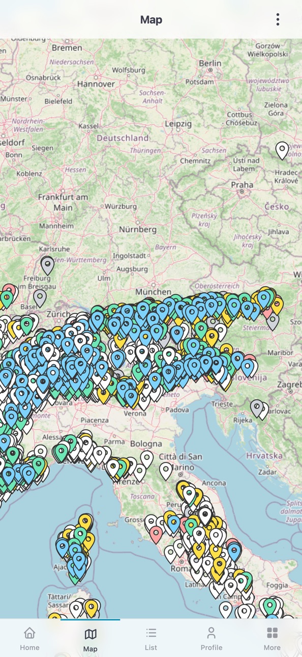
OpenCanyon.org brings the canyon database from opencanyon.org to your smartphone. The app works online and offline and is suitable for planning at home and for use on location.
Features
• Offline mode – save canyons including images, topos and descriptions locally and use them without an internet connection
• Map search – find canyons on the map
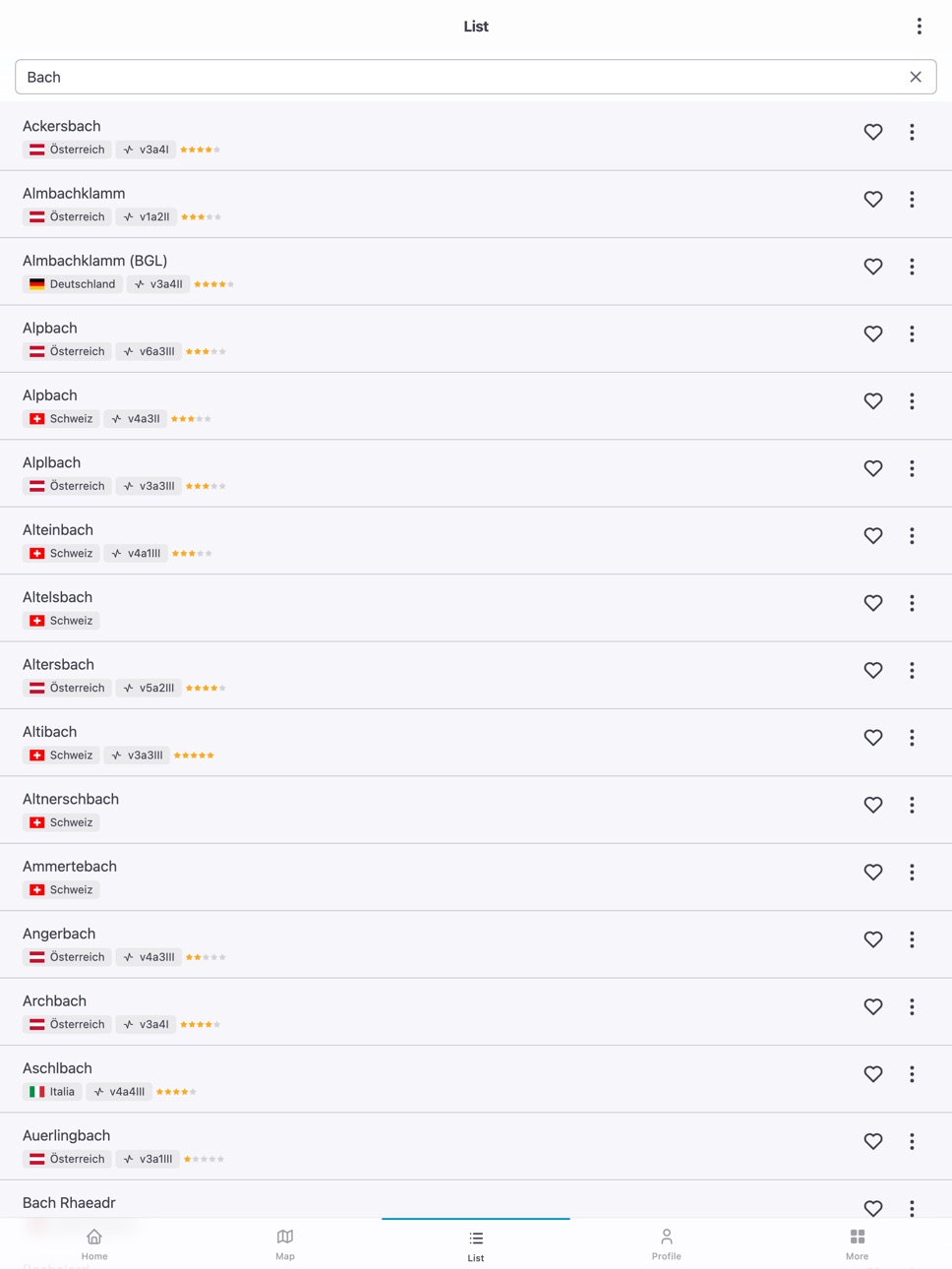
• Filters and full-text search – by name, country, duration, difficulty, number of rappels and rating
• Detail view – key data, description, GPS coordinates, trip reports, photos and links
• Navigation – open coordinates in Apple Maps, Google Maps, Organic Maps or Swisstopo
• GPX export – export the main coordinate of a canyon tour as GPX
• Community reports – descents and feedback from other users
• Content in German, French, Italian and English
OpenCanyon.org is an open, community-driven platform.
Important safety notice
Canyoning is a demanding and potentially dangerous outdoor activity. It requires physical fitness, technical skill, proper equipment and thorough preparation. The information in this app does not replace qualified training, local reconnaissance or up-to-date weather and water level reports. Use is at your own risk. Check current conditions before each trip and, when in doubt, consult experienced canyoning guides.
Accessibility
ipadiphonemacrealityDevicetvoswatch
Version history 20 versions
Build 886240283v2.1.92026-05-28 18:48:53
Troubleshooting
Build 884404178v2.1.82026-04-14 15:24:57
Changes since 1.9.9:
• Canyons available offline – images, topos and descriptions can be stored locally and used without an internet connection
• GPX export for the main coordinate of a canyon tour
• Reworked app design and clearer navigation
• Introductory tour through the key functions
• Offline badge and download progress in the canyon list
• Improvements to dropdowns, forms and reports
• Clearer GPS error messages
• Various smaller bug fixes
Build 881791856v1.9.92026-01-30 19:04:49
- Verbesserte Bedienung und Navigation
- Stabilere App mit kleineren Optimierungen
- Behebung kleiner Anzeige- und Funktionsfehler
Build 879046641v1.8.02025-11-02 12:51:35
- Aktualisierte Canyon-Informationen werden nach neuen oder bearbeiteten Meldungen sofort neu geladen
- Verbesserte Offline-Datenbank und Synchronisation sorgen für mehr Stabilität und weniger Fehlermeldungen
Build 878107681v1.7.42025-09-16 15:23:21
- Verbesserte Kontextmenüs: werden jetzt korrekt angezeigt, ohne abgeschnitten zu werden.
- Einfachere Datumsauswahl – mobile Tastaturen öffnen sich nicht mehr unnötig.
- Textfelder und Zahleneingaben reagieren sofort ohne Verzögerungen.
- Stabilitätsverbesserungen und kleine Optimierungen.
Build 878002597v1.7.22025-09-12 07:28:24
- Design: Einheitliches Dunkel‑Design.
- Karten: Vollbild‑Karten auf iOS entfernt.
- Stabilität: Spürbar flüssiger – besseres Scrollen in Modalen, stabile untere Leiste und Karten/Listen.
Build 876647024v1.6.72025-07-24 07:41:36
- Allgemeine Software-Updates und Leistungsverbesserungen
- Visuelle Bestätigung (Toast) bei erfolgreicher Datenbank-Aktualisierung
- Behebung verschiedener Fehler und Stabilitätsverbesserungen
Build 874503757v1.5.172025-05-04 15:01:28
- Toast-Benachrichtigungen anstatt Dialoge
- Erweiterte Filteroptionen: nach Land filtern und Anzahl der Startseiten-Einträge anpassen
- Integrierter Login-Bereich mit Registrierung und „Passwort vergessen“-Funktion
- Überarbeitete Übersetzungen
Build 873209424v1.14.112025-03-13 11:36:40
- Ein Fehler in der Datenbank wurde behoben
Build 872915865v1.4.102025-03-04 06:09:39
- Neue experimentelle Karte mit SwissTopo-Integration
- Eigener Standort jetzt direkt auf der Karte sichtbar
- Favoriten-Icon wird ausgefüllt, wenn ein Canyon in einer Liste gespeichert ist
- Deep Links zu Canyons – Teile Links, die direkt die App und den Canyon öffnen
- Canyons nach Land & Region anzeigen
Build 870651552v1.3.192024-11-26 21:24:57
- Neues Benutzer-Menü: Verbesserte Navigation und Übersichtlichkeit
- Favoriten: Favoriten einfach verwalten und jederzeit einsehen
- Bilderauswahl: Mehrere Bilder gleichzeitig für Begehungen wählen
- Feedback: Option zur Angabe einer E-Mail für Rückmeldungen
- Optimierungen: Kleine Anpassungen für ein besseres Nutzererlebnis
Build 869161180v1.2.92024-09-22 15:03:39
- Spanische Übersetzung optimiert
- Korrekturen und Verbesserungen
Build 868023695v1.2.72024-08-07 15:58:21
- Transportinformationen werden nun in den Details angezeigt
- In der Ansicht "Liste" öffnen sich die Details nun auch bei einem Klick auf den Titel
- Der Bearbeiten-Button wird nicht mehr bei Reports angezeigt, die nicht vom Benutzer selbst erfasst wurden
- Die Einstellung "Systemmeldungen einblenden" wird jetzt gespeichert
Build 867797070v1.2.62024-07-29 04:15:48
Number of abseils is now displayed in the canyon detail
Build 867496571v1.2.52024-07-16 11:26:18
Fixed a bug that caused some report images to be displayed too large
Build 867300135v1.2.42024-07-07 11:48:32
- Images of inspections are displayed
- Pictures of inspections can be uploaded
- It can be specified who also took part in an inspection
- Error handling has been adjusted/improved
Build 866981519v1.1.152024-06-26 11:58:00
- Fixed a bug that caused the canyons to be included twice after a manual update of the database
Build 866829924v1.1.142024-06-20 16:45:40
- Literature is displayed in the details
- Warnings are displayed in the details
- Warnings are displayed in the map
- Filter by season
- Map rotation deactivated
- Inspections can be edited (for 14 days)
- Own location on the map (not live)
- Statistics are displayed in the profile
- My ascents are displayed in the profile
- Only the database can now be reset in the settings
Build 866249969v1.0.212024-06-11 04:26:06
Update of the offline canyon database
Build 864004093v1.0.162024-05-27 14:14:38
No pricing data captured yet — comparisons appear once the app has paid storefronts or in-app purchases.
Availability 1 of 1 storefronts
| Region | Language | Price | Ratings | Avg | Version |
|---|---|---|---|---|---|
| US | en-US | Free | 0 | — | 2.1.9 |
Change log 24 changes · US
✎
releaseNotes updated
Troubleshooting
✎
description updated
OpenCanyon.org brings the canyon database from opencanyon.org to your smartphone. The app works online and offline and is suitable for planning at home and for
✎
subtitle updated
Offline canyoning database
✎
name updated
OpenCanyon.org
◆
Version 2.1.9 released
Troubleshooting
◆
Version 2.1.8 released
Changes since 1.9.9:
• Canyons available offline – images, topos and descriptions can be stored locally and used without an internet connection
• GPX export for the main coordinate of a canyon tour
• Reworked app design and clearer navigat
◆
Version 1.9.9 released
- Verbesserte Bedienung und Navigation
- Stabilere App mit kleineren Optimierungen
- Behebung kleiner Anzeige- und Funktionsfehler
◆
Version 1.8.0 released
- Aktualisierte Canyon-Informationen werden nach neuen oder bearbeiteten Meldungen sofort neu geladen
- Verbesserte Offline-Datenbank und Synchronisation sorgen für mehr Stabilität und weniger Fehlermeldungen
◆
Version 1.7.4 released
- Verbesserte Kontextmenüs: werden jetzt korrekt angezeigt, ohne abgeschnitten zu werden.
- Einfachere Datumsauswahl – mobile Tastaturen öffnen sich nicht mehr unnötig.
- Textfelder und Zahleneingaben reagieren sofort ohne Verzögerungen.
-
◆
Version 1.7.2 released
- Design: Einheitliches Dunkel‑Design.
- Karten: Vollbild‑Karten auf iOS entfernt.
- Stabilität: Spürbar flüssiger – besseres Scrollen in Modalen, stabile untere Leiste und Karten/Listen.
◆
Version 1.6.7 released
- Allgemeine Software-Updates und Leistungsverbesserungen
- Visuelle Bestätigung (Toast) bei erfolgreicher Datenbank-Aktualisierung
- Behebung verschiedener Fehler und Stabilitätsverbesserungen
◆
Version 1.5.17 released
- Toast-Benachrichtigungen anstatt Dialoge
- Erweiterte Filteroptionen: nach Land filtern und Anzahl der Startseiten-Einträge anpassen
- Integrierter Login-Bereich mit Registrierung und „Passwort vergessen“-Funktion
- Überarbeitete Übersetz
◆
Version 1.14.11 released
- Ein Fehler in der Datenbank wurde behoben
◆
Version 1.4.10 released
- Neue experimentelle Karte mit SwissTopo-Integration
- Eigener Standort jetzt direkt auf der Karte sichtbar
- Favoriten-Icon wird ausgefüllt, wenn ein Canyon in einer Liste gespeichert ist
- Deep Links zu Canyons – Teile Links, die direkt
◆
Version 1.3.19 released
- Neues Benutzer-Menü: Verbesserte Navigation und Übersichtlichkeit
- Favoriten: Favoriten einfach verwalten und jederzeit einsehen
- Bilderauswahl: Mehrere Bilder gleichzeitig für Begehungen wählen
- Feedback: Option zur Angabe einer E-Mai
◆
Version 1.2.9 released
- Spanische Übersetzung optimiert
- Korrekturen und Verbesserungen
◆
Version 1.2.7 released
- Transportinformationen werden nun in den Details angezeigt
- In der Ansicht "Liste" öffnen sich die Details nun auch bei einem Klick auf den Titel
- Der Bearbeiten-Button wird nicht mehr bei Reports angezeigt, die nicht vom Benutzer selbs
◆
Version 1.2.6 released
Number of abseils is now displayed in the canyon detail
◆
Version 1.2.5 released
Fixed a bug that caused some report images to be displayed too large
◆
Version 1.2.4 released
- Images of inspections are displayed
- Pictures of inspections can be uploaded
- It can be specified who also took part in an inspection
- Error handling has been adjusted/improved
◆
Version 1.1.15 released
- Fixed a bug that caused the canyons to be included twice after a manual update of the database
◆
Version 1.1.14 released
- Literature is displayed in the details
- Warnings are displayed in the details
- Warnings are displayed in the map
- Filter by season
- Map rotation deactivated
- Inspections can be edited (for 14 days)
- Own location on the map (not live
◆
Version 1.0.21 released
Update of the offline canyon database
◆
Version 1.0.16 released