Home › Health & Fitness

 US
US
1 of 1 storefronts
Content in en-US
Content in en-US
Information
Preview 2 platforms
iPhone 8 images




iPad 7 images


What’s New Version 2.189
Update to Gordon River starting instructions.
Description
West Coast Trail is the essential guide for hikers planning to backpack the legendary West Coast Trail on Vancouver Island, BC.
Plan every detail of your hike with all the essentials at your fingertips:
• Customize your trip with unique dates, direction (north/south), and campsites.
• Automatic tide calculations for tide-restricted beach sections using official Tofino charts, adjusted for Daylight Savings.
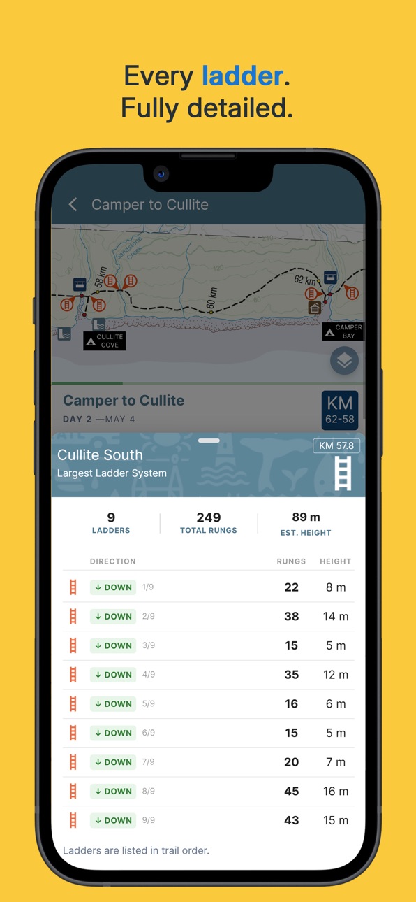
• Interactive map with points of interest, trail highlights, shipwrecks, water sources, and ladder locations (with rung counts).
• Daily summaries showing distances, ladders, and tides.
• Campsite satellite images and detailed trail descriptions.
• Sunrise and sunset times for your exact dates.
• Save multiple trip plans or explore options for a YOYO hike.
In-App Upgrade: PRO Pass
The PRO Pass is a single-year, non-renewing purchase that unlocks all trail features:
• Trail Access – use the app fully offline with no cell service; remains unlocked during your hiking dates.
• On-Trail Map - full screen immersive map for navigation on the trail with GPS locate
• Trail Weather – get precision forecasts for every major campsite.
A PRO Pass is valid for the year shown (e.g. a “2026 PRO Pass” is valid through December 31, 2026).
It’s not a subscription — it never auto-renews and doesn’t need to be cancelled.
Note: The PRO Pass is not a trail permit. A Parks Canada West Coast Trail Backcountry Use Permit is still required to hike.
Free Version
The free version is fully functional for trip planning and ad-free, but it locks during your actual hiking dates.
Upgrade to PRO to stay trail-ready and access all offline features.
Terms & Conditions:
https://www.westcoasttrail.app/terms
In-App Purchases US pricing
One-Time Purchases
PRO Pass for 2026 Season$29.99
Capabilities
In-App Purchases
Accessibility
ipadiphonemacrealityDevicetvoswatch
Version history 25 versions
Build 887817917v2.1892026-07-04 22:02:17
Update to Gordon River starting instructions.
Build 887558706v2.1852026-06-28 22:56:47
Map edits
Build 887497502v2.1842026-06-26 19:32:30
- bug fixes and typos
- missing shipwrecks on segment-maps
- missing ladders near dare pt on segment maps
Build 887396231v2.1822026-06-25 13:32:32
Minor edits:
- Improved section note editing
- Dare-Cribs Forest Trail updates
- Adrenaline water source edit
- Trailbus charter van options
Build 886756179v2.1772026-06-10 17:02:19
- Fix regression where SOBO hikers see ladders in incorrect order on large map.
- Fix am/pm error in bus schedule
- Update Nytom hours
Build 886460532v2.1752026-06-03 16:48:29
- Simplified Trail Beta page
- Improved Weather layout and add rain intensity
- Map updates: new Dare beach connector trail.
Build 886176442v2.1722026-05-27 19:41:17
- New Tide Control on the main navigation map allows for quick access to live tide info
- Fixed crash when importing a shared itinerary
- Cleaned up water-source list in the Trail Beta reporting flow
- Other minor bug fixes.
Build 885493128v2.1642026-05-11 14:30:37
Updated to 2026 pricing of Crabshack Menu and Gordon River Parking
Build 885033496v2.1622026-04-28 16:54:21
Critical hot-fix to address crash on startup with a fresh-install.
Build 884077001v2.1602026-04-26 20:24:30
- Fix timezone issue with tide tables when running on different-day zones (eg. Japan)
- Upgrade core libraries with security updates
Build 883519722v2.1502026-04-02 19:53:49
On-Trail map - fully immersive full-screen map.
Build 882804577v2.672026-02-26 19:49:50
1. Permit Search now available in Guide
2. Fixed a bug in Owen Pt Crossing Plans where a different user timezone causes incorrect tide data lookup for "lowest tide" plan.
Build 882656160v2.622026-02-25 03:19:36
- New design for Owen Pt Calendar and Crossing Plans - simplifies schedule and includes Camper in the calculations.
- Fix a bug that caused May 20th to incorrectly show as impassable.
- Fix parking page bug
- Elevate Emergency page to top level menu
- Restore missing pins on trailhead maps
Build 882397147v2.512026-02-13 20:38:16
- Fixes a blocking bug with YOYO trips
- New Contacts Page Layout
Build 882238753v2.452026-02-06 23:50:22
Minor release that fixes a critical bug where if there is a new update pending - update notification shows, but tapping does nothing. With this fix - it correctly opens the App Store page for the App where you can download the new update.
Build 882178929v2.442026-02-05 15:30:11
- New Guidebook Pages
- Travel Plans helps transportation to and from trailheads
- Trailbus Schedule Page
- Parking Page
- Updated Emergency Page
- Updated Owen Pt Guide
Build 882103991v2.362026-02-03 15:23:10
1. Fixes critical bug with Owen Pt Travel Plans where NOBO hikers only see SOBO plans (was introduced in 2.30)
2. Hiker Reports is now "Trail Beta"
3. Guide has new "Tide Charts" page that shows the tidal curve in visual form
Build 881873480v2.302026-01-27 06:29:58
- Trip Setup now supports YOYO (Turn-Around) trips
- Simplified app settings
- Improved Sharing dialog
- Minor UX edits and changes
Build 879818338v2.11.02025-11-17 20:50:25
Security updates and migration to new StoreKit2 platform APIs.
Build 878862158v2.5.02025-10-21 17:15:40
- Updated for 2026 season with 2026 tide data.
- Fix white-screen on startup bug with strong cellular signal but no data service (Usually Canadian phone rejecting roaming to US tower)
- Changed from subscription model to "2026 PRO Pass"
Build 877913070v1.15.102025-09-08 19:37:10
- Bug fix for printing tide charts on mobile, some days of tide data were being cropped from the printed page.
Build 877489194v1.15.82025-08-22 23:36:10
Updated Nitinaht Trailhead map to show both pickup (by motel) and drop off (by campground) locations for the shuttle to the Trailbus. Previously incorrectly shown as a single location.
Build 877047305v1.15.22025-08-07 21:43:10
Fix bug with in-App update notifications.
Build 876971476v1.14.42025-08-05 14:02:26
Minor Fixes:
- Relocated Shuttle Stop in Nitinaht Village to near campground
- Updated Crabshack Menu Prices
- Improved Print Layout
- Typos in trail descriptions
Build 875886654v1.14.22025-06-25 20:59:30
- Print backup tides charts on mobile
- Helper for YOYOs in trip setup
- Four night camp suggestions
- Default shipwrecks layer to ON
- Crabshack prices updated for 2025
- Minor bug fixes
Price history by region
Currency
Show
Columns
Search
Availability 1 of 1 storefronts
| Region | Language | Price | Ratings | Avg | Version |
|---|---|---|---|---|---|
| US | en-US | Free | 15 | 4.9 | 2.189 |
Change log 29 changes · US
✎
releaseNotes updated
Update to Gordon River starting instructions.
✎
description updated
West Coast Trail is the essential guide for hikers planning to backpack the legendary West Coast Trail on Vancouver Island, BC.
Plan every detail of your hike
✎
subtitle updated
Essential Backpackers Guide
✎
name updated
West Coast Trail
◆
Version 2.189 released
Update to Gordon River starting instructions.
◆
Version 2.185 released
Map edits
◆
Version 2.184 released
- bug fixes and typos
- missing shipwrecks on segment-maps
- missing ladders near dare pt on segment maps
◆
Version 2.182 released
Minor edits:
- Improved section note editing
- Dare-Cribs Forest Trail updates
- Adrenaline water source edit
- Trailbus charter van options
◆
Version 2.177 released
- Fix regression where SOBO hikers see ladders in incorrect order on large map.
- Fix am/pm error in bus schedule
- Update Nytom hours
◆
Version 2.175 released
- Simplified Trail Beta page
- Improved Weather layout and add rain intensity
- Map updates: new Dare beach connector trail.
◆
Version 2.172 released
- New Tide Control on the main navigation map allows for quick access to live tide info
- Fixed crash when importing a shared itinerary
- Cleaned up water-source list in the Trail Beta reporting flow
- Other minor bug fixes.
◆
Version 2.164 released
Updated to 2026 pricing of Crabshack Menu and Gordon River Parking
◆
Version 2.162 released
Critical hot-fix to address crash on startup with a fresh-install.
◆
Version 2.160 released
- Fix timezone issue with tide tables when running on different-day zones (eg. Japan)
- Upgrade core libraries with security updates
◆
Version 2.150 released
On-Trail map - fully immersive full-screen map.
◆
Version 2.67 released
1. Permit Search now available in Guide
2. Fixed a bug in Owen Pt Crossing Plans where a different user timezone causes incorrect tide data lookup for "lowest tide" plan.
◆
Version 2.62 released
- New design for Owen Pt Calendar and Crossing Plans - simplifies schedule and includes Camper in the calculations.
- Fix a bug that caused May 20th to incorrectly show as impassable.
- Fix parking page bug
- Elevate Emergency page to top l
◆
Version 2.51 released
- Fixes a blocking bug with YOYO trips
- New Contacts Page Layout
◆
Version 2.45 released
Minor release that fixes a critical bug where if there is a new update pending - update notification shows, but tapping does nothing. With this fix - it correctly opens the App Store page for the App where you can download the new update.
◆
Version 2.44 released
- New Guidebook Pages
- Travel Plans helps transportation to and from trailheads
- Trailbus Schedule Page
- Parking Page
- Updated Emergency Page
- Updated Owen Pt Guide
◆
Version 2.36 released
1. Fixes critical bug with Owen Pt Travel Plans where NOBO hikers only see SOBO plans (was introduced in 2.30)
2. Hiker Reports is now "Trail Beta"
3. Guide has new "Tide Charts" page that shows the tidal curve in visual form
◆
Version 2.30 released
- Trip Setup now supports YOYO (Turn-Around) trips
- Simplified app settings
- Improved Sharing dialog
- Minor UX edits and changes
◆
Version 2.11.0 released
Security updates and migration to new StoreKit2 platform APIs.
◆
Version 2.5.0 released
- Updated for 2026 season with 2026 tide data.
- Fix white-screen on startup bug with strong cellular signal but no data service (Usually Canadian phone rejecting roaming to US tower)
- Changed from subscription model to "2026 PRO Pass"
◆
Version 1.15.10 released
- Bug fix for printing tide charts on mobile, some days of tide data were being cropped from the printed page.
◆
Version 1.15.8 released
Updated Nitinaht Trailhead map to show both pickup (by motel) and drop off (by campground) locations for the shuttle to the Trailbus. Previously incorrectly shown as a single location.
◆
Version 1.15.2 released
Fix bug with in-App update notifications.
◆
Version 1.14.4 released
Minor Fixes:
- Relocated Shuttle Stop in Nitinaht Village to near campground
- Updated Crabshack Menu Prices
- Improved Print Layout
- Typos in trail descriptions
◆
Version 1.14.2 released
- Print backup tides charts on mobile
- Helper for YOYOs in trip setup
- Four night camp suggestions
- Default shipwrecks layer to ON
- Crabshack prices updated for 2025
- Minor bug fixes