Home › Navigation

 US
US
1 of 1 storefronts
Content in en-US
Content in en-US
Information
Apple ID598750261
Bundle IDnet.skycharts.scxp
SellerSeller
Min iOS12.0
Min macOS11.0
Device familiesiphone, ipad, ipod
Released2016-09-27
Copyright© 2016-2026
Privacy policyLink ↗
Preview 2 platforms
iPhone 8 images





iPad 5 images


What’s New Version 5.5.1
Support for iOS26.4
Description
Current FAA aviation charts updated every 28 days, including approach plates! Includes basic international airport data from ourairports.net and openAIP.net.
Please note that for charts outside of USA non current ONC/VFR with a current openAIP overlay is available, but NO IFR charts or plates are available.
Includes a free 30 day trial!
If you wish to continue using SkyCharts after the trial, please purchase a $3.99/month subscription. Note that buying a subscription does not unlock any additional features.
See full description regarding auto-renewing subscriptions, privacy policy and EULA below.
For USA/Alaska, the application has all current FAA VFR (sectional+WAC), IFR (High and Low), TAC, FLY (flip side of TAC chart), Helicopter, Gulf Coast WAC, Gulf Of America, and Wall aviation charts.
Grand Canyon charts are included in the TAC charts, and Bahamas and Mexico as WAC charts.
Also included is a METAR/TAF overlay, and an IFR overlay to view routes on top of VFR charts.
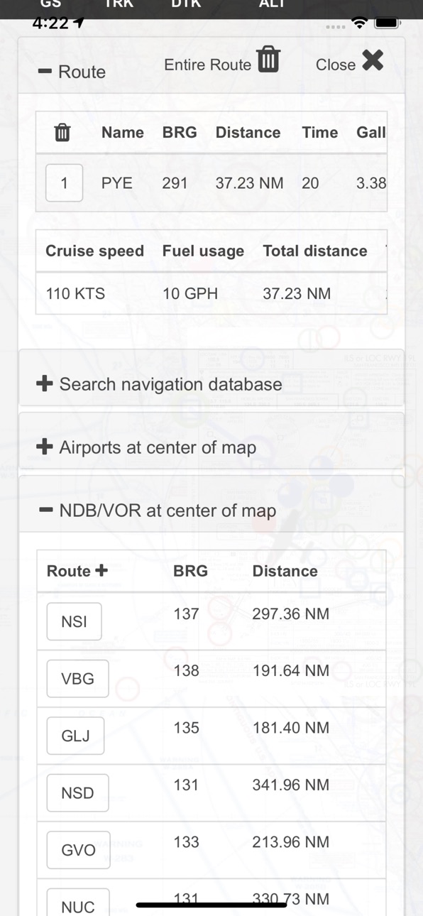
Its very easy to create and modify routes directly on the map or by drag&drop in table.
Navigation readout is configurable to fit exactly what you want to see. It also has a nifty auto-layout feature that selects fields for you in both portrait and landscape mode.
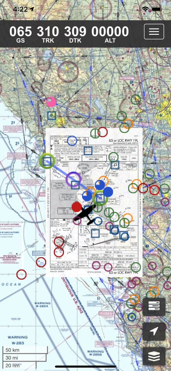
DOUBLE TAP on map to view A/FD and approach plates.
Map has VFR/IFR/LIFR color-coded weather METARs, with orange TAFs.
SUA (Special Use Airspace) information is also available.
Download charts and plates for offline usage.
Features:
* Fast zoom/scroll of included charts using standard gestures.
* Allows download of charts for offline usage. Charts are selected on a region basis.
* Navigation computes GS, TRK, DTK, DIS & ETE to final waypoint.
* METAR/TAF color coded dots according to ADDS: http://www.skycharts.net/?page_id=421
* Double tap on airport to select A/FD and TPPs/IAPs to view.
* Huge built-in navigation database, with all 20,000 airports, 45,000 FAA IFR/VFR navigation fixes and 2,100 FAA VOR/ADF fixes.
For more information, please see the webpage at
http://www.skycharts.net
The monthly subscription of SkyCharts XC aviation data of $3.99 is auto-renewed. Payment will be charged to your iTunes/App Store account at confirmation of purchase. You can turn off auto-renew at any time from your iTunes/App Store account settings, but you must do so at least 24 hours before the end of the current subscription period to avoid being billed for the next cycle. No cancellation of the current subscription is allowed during the active period. Any unused portion of a free trial period will be forfeited when you purchase a subscription to SkyCharts XC.
The privacy policy and EULA can be found here:
http://www.skycharts.net/?page_id=1465
For fast response to all questions, comments or suggestions, please email support@skycharts.net
Capabilities
In-App Purchases
Accessibility
ipadiphonemacrealityDevicetvoswatch
Version history 25 versions
Build 883678680v5.5.12026-03-24 21:33:05
Support for iOS26.4
Build 861417377v5.5.02023-11-12 19:06:15
Built in 2311 database
Build 838791020v5.4.92020-11-10 18:08:08
Bugfixes
Built in 2012 database
Build 837255337v5.4.82020-08-07 04:33:16
Minor bugfixes
Build 837038555v5.4.72020-07-29 03:38:19
Updates and improvements
Built in 2008 database
Build 832588193v5.4.62019-09-02 16:01:25
Support for iPhoneX
Built in 1909 database
Build 827209430v5.4.52018-05-20 00:09:32
*Bugfix for user defined waypoint
*You can now download the A/FD and approach plates on an airport basis! When used in conjunction with 'Charts only' option you can get away with downloading half the amount of data compared to previous versions. Note: obviously you then have to make sure all the airports you intend to use have been downloaded!
Build 826873369v5.4.42018-04-30 21:55:15
*Moved subscription info to the top and the GDPR to the bottom on the Subscription page in order to easier find info on smaller devices.
*Built in 1805 database
Build 826735289v5.4.32018-04-19 22:15:32
*GDPR updates
*METAR/TAF now stays up even when map is moved
*Built in 1804 database
Build 826421952v5.4.22018-03-24 15:50:54
*Bugfixes
In the previous release we forgot to mention that the openAIP VFR world overlay is now available!
Like most other layers you must download a region before you can view them.
Build 825922541v5.4.12018-02-27 06:46:55
*More international data!
Build 825838911v5.4.02018-02-01 03:26:03
*New layers! Now displays NDB/VOR, Airports and Fixes on charts!
*Built in 1802 database
Build 825664517v5.3.92018-01-18 15:43:43
*Bugfixes
*Built in 1801 database
Build 823799678v5.3.82017-09-27 04:00:32
*bugfixes
Build 823532606v5.3.72017-09-05 04:17:21
*bugfixes
Build 823490703v5.3.62017-09-02 05:24:20
*bugfixes
*built in 1709 database
Build 822586489v5.3.52017-06-18 17:31:32
*Stability fixes
*Built in 1706 database
*Manual lat/long support
*Routes no longer always contain direct
Please update to enjoy the latest features!
Build 821422426v5.3.42017-03-22 05:18:03
Built in 1703 database
Corrected download info for South America
Build 821088045v5.3.32017-02-26 20:02:17
Background processing adjustment - adjust automatically for type of device.
Upcoming Brazil charts! (available in cycle 1703).
Build 820855855v5.3.22017-02-08 16:49:09
Now with autoPlates!
The app will suggest geo-referenced approaches from the prevailing wind and your center of map.
You need to download a region for this to work.
You can turn off this feature by selecting Layers->Overlay->AUTO
AutoPlates is only available on devices running iOS10.
Also:
Region download percentage now counts total size and not number of files
Bugfixes
Built in 1702 database
Build 820562386v5.2.82017-01-18 01:31:47
*Built in 1701 database
*Ads now only show up when trial has expired
*Fix for TAC charts
*Bugfixes
Build 820326864v5.2.72017-01-03 07:10:34
Now with built in flight simulator communication to X-Plane and Elite!
Automatically pick up position, speed and heading when sim-flying.
Perfect for doing practice approaches using the geo-referenced plates!
Please see this page how to setup X-Plane.
http://www.skycharts.net/?page_id=228
Build 820184093v5.2.62016-12-17 05:16:21
Bugfixes
Build 820064064v5.2.52016-12-15 04:26:43
Built in 1613 database and bug fixes.
Build 819999291v5.2.22016-12-05 02:20:41
Updates and bugfixes to reduce memory usage.
No pricing data captured yet — comparisons appear once the app has paid storefronts or in-app purchases.
Availability 1 of 1 storefronts
| Region | Language | Price | Ratings | Avg | Version |
|---|---|---|---|---|---|
| US | en-US | Free | 1 | 5.0 | 5.5.1 |
Change log 29 changes · US
✎
releaseNotes updated
Support for iOS26.4
✎
description updated
Current FAA aviation charts updated every 28 days, including approach plates! Includes basic international airport data from ourairports.net and openAIP.net.
P
✎
subtitle updated
Geo plates and charts
✎
name updated
SkyCharts XC EFB
◆
Version 5.5.1 released
Support for iOS26.4
◆
Version 5.5.0 released
Built in 2311 database
◆
Version 5.4.9 released
Bugfixes
Built in 2012 database
◆
Version 5.4.8 released
Minor bugfixes
◆
Version 5.4.7 released
Updates and improvements
Built in 2008 database
◆
Version 5.4.6 released
Support for iPhoneX
Built in 1909 database
◆
Version 5.4.5 released
*Bugfix for user defined waypoint
*You can now download the A/FD and approach plates on an airport basis! When used in conjunction with 'Charts only' option you can get away with downloading half the amount of data compared to previous vers
◆
Version 5.4.4 released
*Moved subscription info to the top and the GDPR to the bottom on the Subscription page in order to easier find info on smaller devices.
*Built in 1805 database
◆
Version 5.4.3 released
*GDPR updates
*METAR/TAF now stays up even when map is moved
*Built in 1804 database
◆
Version 5.4.2 released
*Bugfixes
In the previous release we forgot to mention that the openAIP VFR world overlay is now available!
Like most other layers you must download a region before you can view them.
◆
Version 5.4.1 released
*More international data!
◆
Version 5.4.0 released
*New layers! Now displays NDB/VOR, Airports and Fixes on charts!
*Built in 1802 database
◆
Version 5.3.9 released
*Bugfixes
*Built in 1801 database
◆
Version 5.3.8 released
*bugfixes
◆
Version 5.3.7 released
*bugfixes
◆
Version 5.3.6 released
*bugfixes
*built in 1709 database
◆
Version 5.3.5 released
*Stability fixes
*Built in 1706 database
*Manual lat/long support
*Routes no longer always contain direct
Please update to enjoy the latest features!
◆
Version 5.3.4 released
Built in 1703 database
Corrected download info for South America
◆
Version 5.3.3 released
Background processing adjustment - adjust automatically for type of device.
Upcoming Brazil charts! (available in cycle 1703).
◆
Version 5.3.2 released
Now with autoPlates!
The app will suggest geo-referenced approaches from the prevailing wind and your center of map.
You need to download a region for this to work.
You can turn off this feature by selecting Layers->Overlay->AUTO
AutoPlates
◆
Version 5.2.8 released
*Built in 1701 database
*Ads now only show up when trial has expired
*Fix for TAC charts
*Bugfixes
◆
Version 5.2.7 released
Now with built in flight simulator communication to X-Plane and Elite!
Automatically pick up position, speed and heading when sim-flying.
Perfect for doing practice approaches using the geo-referenced plates!
Please see this page how to
◆
Version 5.2.6 released
Bugfixes
◆
Version 5.2.5 released
Built in 1613 database and bug fixes.
◆
Version 5.2.2 released
Updates and bugfixes to reduce memory usage.