Home › Navigation

 US
US
1 of 1 storefronts
Content in en-US
Content in en-US
Information
Preview 2 platforms
iPhone 10 images




iPad 10 images


What’s New Version 150.0.0
- Relief Shading
- Automatic Routing
- Lake Temperatures
- Compiled with laest version of Xcode
Description
Marine Navigation App offers access to NOAA marine vector charts, freshwater lake maps, USACE inland river maps. Only marine GPS app to have route assistance with Voice Prompts for marine navigation. It has route manager to create new boating routes or import existing GPX/KML routes. It supports Nautical Charts course up orientation. Includes Tide & Currents prediction.
* Hardware/GPU accelarated vector charts (text stays upright on rotation).
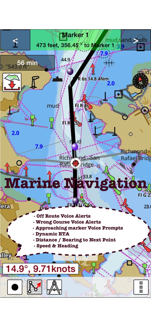
* Voice Prompts for marine navigation (requires GPS )
* 1ft / 3ft depth contour maps for anglers for selected lake maps.
* Supports GPX/KML for boating route editing/import.
* Tide & Currents prediction.
* Seamless chart quilting of marine charts
* Enter way points
* Record tracks, Autofollow with realtime track overlay
* Voice Prompts for marine navigation (requires GPS )
-prompts when approaching a boating route marker
-Continous distance and ETA updates
-Alerts when sailing/boating off route
-Alerts when boating in wrong direction
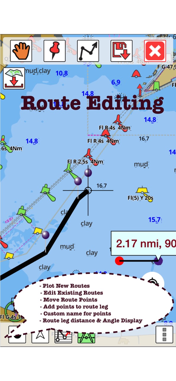
*Route Editing/Creation
-Create routes from scratch
-Edit existing GPX/KML routes.
-Add custom description to any route point.
-Drop markers along route.
* Offline NOAA marine, lake & river charts
-Visually download using grid
-Textual search
* Tide & Currents
- High / Low tides.
- Tidal Currents.
- Active currents stations.
*Seamless chart quilting of marine charts
*Distance Bearing tool
*Create custom way points
- Using GPS
-Select point on map
-Manually enter latitude & longitude coordinates
*Pan/Zoom/My Location
* Record Marine GPS tracks
* View tracks overlay
* Live track animation
* Track analytics/stats
* Export GPX trcks.
-Export to SDCard
-Share GPX tracks with friends.
* Auto Follow Mode (Course up)
-Continuously updates boat's location on chart
- Adjustable update frequency
Sample Nautical Charts (please visit http://gpsnauticalcharts.com/main/folio-catalog-nautical-charts-app for complete list)
SUGARLOAF KEY-KEY WEST
PORT RICHEY TAMPA BAY - CLEARWATER HBR
EAST BAY-WEST BAY FLORIDA
ST JOSEPH, ST ANDREW BAYS
INTRACOASTAL WATERWAY MATECUMBE-GRASSY KEY
CHESAPEAKE BAY CAPE CHARLES-NORFOLK HARBOR
ANCLOTE KEYS-CRYSTAL RIVER
ST JOSEPH SOUND
MIAMI HARBOR
Minnesota lakes - Kabetogama, Minnetonka, Waconia,Leech,Mille Lacs
Lake Keowee,Jocassee,Hartwell,Greenwood,Lake Murray
Mark Twain,Ozarks,Table Rock
Lake St. Clair
Lake Kentucky
KEY WEST-THE MISSISSIPPI RIVER
SAN PEDRO CHANNEL
LAKE MICHIGAN STONY LAKE-POINT BETSIE
APALACHICOLA BAY-CAPE SAN BLAS
EAST CAPE-MORMON KEY
CAPE HENLOPEN-INDIAN RIVER INLET
CHESAPEAKE BAY CAPE HENRY-THIMBLE SHOAL LIGHT
DULUTH-SUPERIOR HARBOR
MONHEGAN ISLAND-CAPE ELIZABETH
LAKE ONTARIO - CLAYTON-FALSE DUCKS ISL
Lake Winnipesaukee
SAN FRANCISCO ENTRANCE
MIAMI-MARATHON, FLORIDA BAY
CAPE MAY-FENWICK ISLAND
MISSISSIPPI RIVER-GALVESTON
CAPE CANAVERAL-KEY WEST
DELAWARE RIVER WILMINGTON-PHILADELPHIA
FLORIDA KEYS SOMBRERO KEY-SAND KEY
SAN PABLO BAY
RAINY LAKE BIG ISLAND MINN-OAKPOINT ISL ONT
INTRACOASTAL WATERWAY - BISCAYNE BAY
EVERGLADES NTL PARK - SHARK RVR-LOSTMANS RVR
MIAMI-MARATHON & FLORIDA BAY
BLACKBURN BAY
LAKE HURON
LAKE TAHOE
STRAITS OF MACKINAC
NORFOLK HARBOR & ELIZABETH RIVER
SAN DIEGO-SANTA ROSA ISLAND
DELAWARE BAY
CHOPTANK RIVER CAMBRIDGE-GREENSBORO
FORT LAUDERDALE PORT EVERGLADES
ST SIMONS SOUND-TOLOMATO RIVER
CHESAPEAKE DELAWARE CANAL
CAPE MENDOCINO
STRAIT OF JUAN DE FUCA ENTRANCE
PORT RICHEY CLEARWATER HBR
PAMPANO BEACH-HALLADALE FLORIDA
LAKE ERIE
LAKE MICHIGAN INCLUDING GREEN BAY
MAIMI-MARATHON and FLORIDA BAY
SANTA CATALINA ISLAND
APALACHICOLA BAY-LAKE WIMICO
Battery Disclaimer:
"Continued use of GPS running in the background can dramatically decrease battery life."
Accessibility
ipadiphonemacrealityDevicetvoswatch
Version history 14 versions
Build 869988786v150.0.02024-10-29 17:19:01
- Relief Shading
- Automatic Routing
- Lake Temperatures
- Compiled with laest version of Xcode
Build 816440341v58.0.02016-02-17 22:16:40
This update from Apple will improve the functionality of this app. No new features are included.
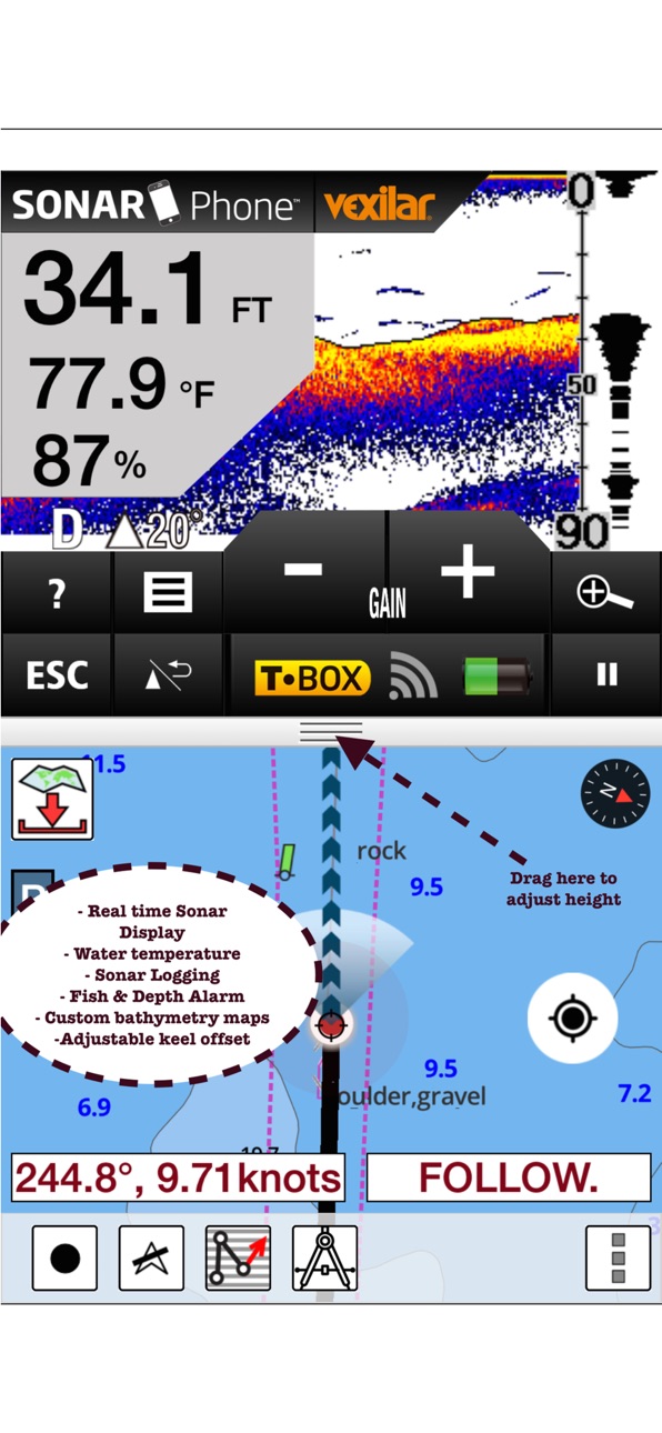
-Support for Object Query, Vexilar
Build 810913321v23.0.02015-01-04 17:02:31
-Verified on iOS8.
Build 630473353v22.0.02014-07-17 21:10:37
- New options for exporting routes.
Build 575962688v21.0.02014-05-06 21:17:15
-Route Editing Enhancements
Build 526532665v20.0.02014-04-08 19:41:49
- New options to create Way Points
Build 485222633v19.0.02014-03-26 04:24:23
- Move Points during Route Editing.
- Add points to an existing Route Leg.
Build 452442653v18.0.02014-03-14 18:48:09
1. Reverse Routes
2. Show both desired bearing/heading and current bearing/heading to next route point in Route Assistance/Voice Assistance Mode.
3. Allow interaction with chart during Auto Follow mode.
4. Show distance and bearing on edge labels during Route Editing.
Build 424922656v16.0.02014-03-04 23:49:50
1. Most lakes created by impoundment of Tennessee river now have HD bathymetry/contours.
2. Export individual waypoints.
Build 373542708v15.0.02014-02-13 08:09:32
- Verified on iOS7
- Compiled with Xcode 5.
Build 293803160v14.0.02014-01-12 21:18:42
1.) Verified on iOS 7.0
2.) Added Georgia Lakes - Carters Lake, Lake Sidney Lanier, Randy Poynter, Allatoona, Walter F George and West Point Lakes
3.) Added South Carolina Lakes - Lake Murray, Lake Greenwood, Lake Keowee, Lake Murray, Lake Hartwell, Lake Jocassee, Lake Wylie
4.) Added 1ft HD bathymetry for Minnesota Lakes - Kabetogama, Minnetonka, Waconia,Leech,Mille Lacs
Build 40602635v12.0.02013-09-27 21:34:43
1.) The app now supports major navigable rivers(Allegheny, Arkansas, Atchafalaya, Cumberland, Green, Illinois, Kanawha, Kaskaskia, Mississippi, Missouri, Monongahela, Ohio, Ouachita, Tennessee etc) in addition to Coast charts.
(Tennesse, inland lakes, reservoirs, in addition to coastal charts. Wherever possible we have tried to add detailed 1ft bathymetry.
2.) Minnesota lakes have been updated to HD (1ft bathymetry). Approximately 1400 out of 1700+ Minnesota lakes now have HD bathymetry.
http://gpsnauticalcharts.com/main/usa-noaa-charts-nautical-charts-app
3.) Real time track overlay is turned on by default with Auto Follow or Record.
4.) In Auto Follow mode, the app now shows the predicted path if the current course is followed.
Build 15640443v11.02013-06-22 23:51:43
1.) The app now supports over 7000 inland lakes and reservoirs, in addition to coastal charts. Wherever possible we have tried to add detailed 1ft bathymetry.
http://gpsnauticalcharts.com/main/usa-noaa-charts-nautical-charts-app
2.) Real time track overlay: This is available when AutoFollow or Record is turned on. Now the app shows the course/route you have already covered so far in real time.
3.) In Auto Follow mode, the app now shows the predicted path if the current course is followed.
4.) This version also includes Bulk download enhancements requested by a few users.
Build 13787434v10.02013-02-12 02:04:54
Price history by region
Currency
Show
Columns
Search
Availability 1 of 1 storefronts
| Region | Language | Price | Ratings | Avg | Version |
|---|---|---|---|---|---|
| US | en-US | USD 29.99 | 19 | 4.2 | 150.0.0 |
Change log 17 changes · US
✎
releaseNotes updated
- Relief Shading
- Automatic Routing
- Lake Temperatures
- Compiled with laest version of Xcode
✎
description updated
Marine Navigation App offers access to NOAA marine vector charts, freshwater lake maps, USACE inland river maps. Only marine GPS app to have route assistance wi
✎
name updated
Marine Navigation-USA Lake Map
◆
Version 150.0.0 released
- Relief Shading
- Automatic Routing
- Lake Temperatures
- Compiled with laest version of Xcode
◆
Version 58.0.0 released
This update from Apple will improve the functionality of this app. No new features are included.
-Support for Object Query, Vexilar
◆
Version 23.0.0 released
-Verified on iOS8.
◆
Version 22.0.0 released
- New options for exporting routes.
◆
Version 21.0.0 released
-Route Editing Enhancements
◆
Version 20.0.0 released
- New options to create Way Points
◆
Version 19.0.0 released
- Move Points during Route Editing.
- Add points to an existing Route Leg.
◆
Version 18.0.0 released
1. Reverse Routes
2. Show both desired bearing/heading and current bearing/heading to next route point in Route Assistance/Voice Assistance Mode.
3. Allow interaction with chart during Auto Follow mode.
4. Show distance and bearing on ed
◆
Version 16.0.0 released
1. Most lakes created by impoundment of Tennessee river now have HD bathymetry/contours.
2. Export individual waypoints.
◆
Version 15.0.0 released
- Verified on iOS7
- Compiled with Xcode 5.
◆
Version 14.0.0 released
1.) Verified on iOS 7.0
2.) Added Georgia Lakes - Carters Lake, Lake Sidney Lanier, Randy Poynter, Allatoona, Walter F George and West Point Lakes
3.) Added South Carolina Lakes - Lake Murray, Lake Greenwood, Lake Keowee, Lake Murray, Lak
◆
Version 12.0.0 released
1.) The app now supports major navigable rivers(Allegheny, Arkansas, Atchafalaya, Cumberland, Green, Illinois, Kanawha, Kaskaskia, Mississippi, Missouri, Monongahela, Ohio, Ouachita, Tennessee etc) in addition to Coast charts.
(Tennesse,
◆
Version 11.0 released
1.) The app now supports over 7000 inland lakes and reservoirs, in addition to coastal charts. Wherever possible we have tried to add detailed 1ft bathymetry.
http://gpsnauticalcharts.com/main/usa-noaa-charts-nautical-charts-app
2.
◆
Version 10.0 released