Home › Photo & Video
Screenshots 2 platforms
iPhone 6 shots · full-res
iPad 3 shots · full-res
Description
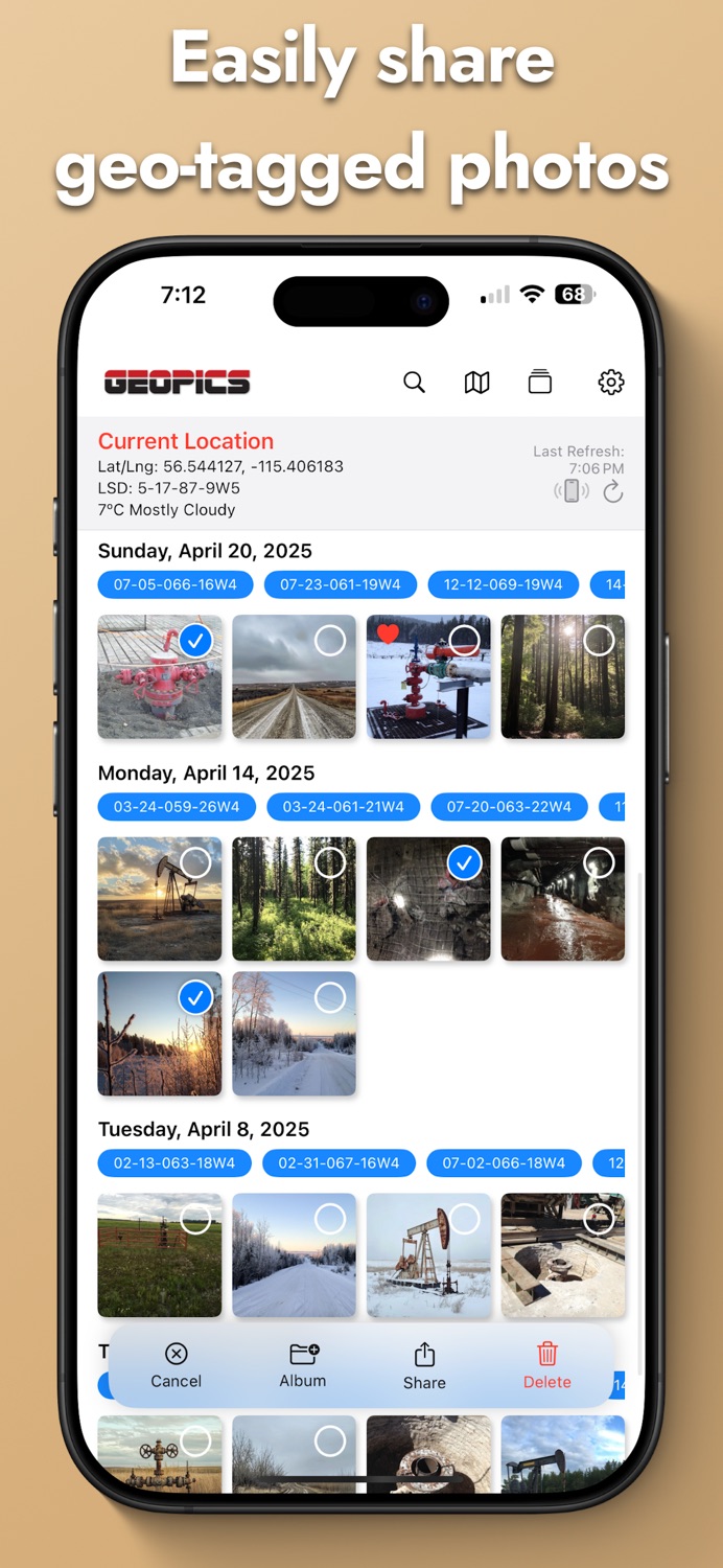
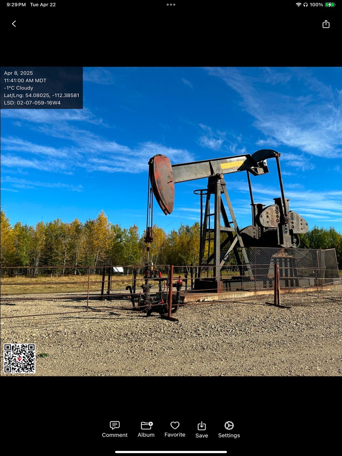
GeoPics transforms your iPhone into a geo-aware field camera—snap, stamp and share location-rich photos in seconds.
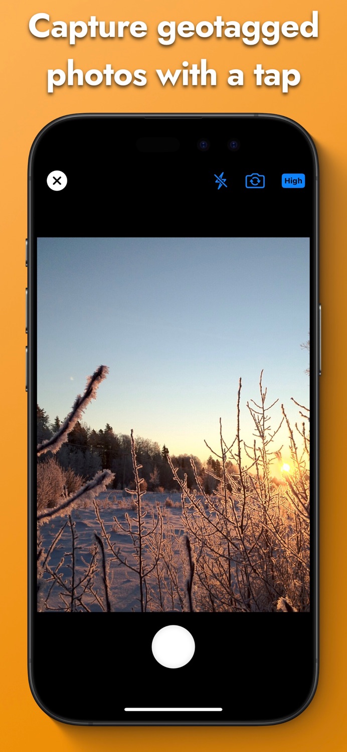
Snap geotagged photos in one tap
• Built-in geo-camera: live preview with flash, gridlines & GPS readout
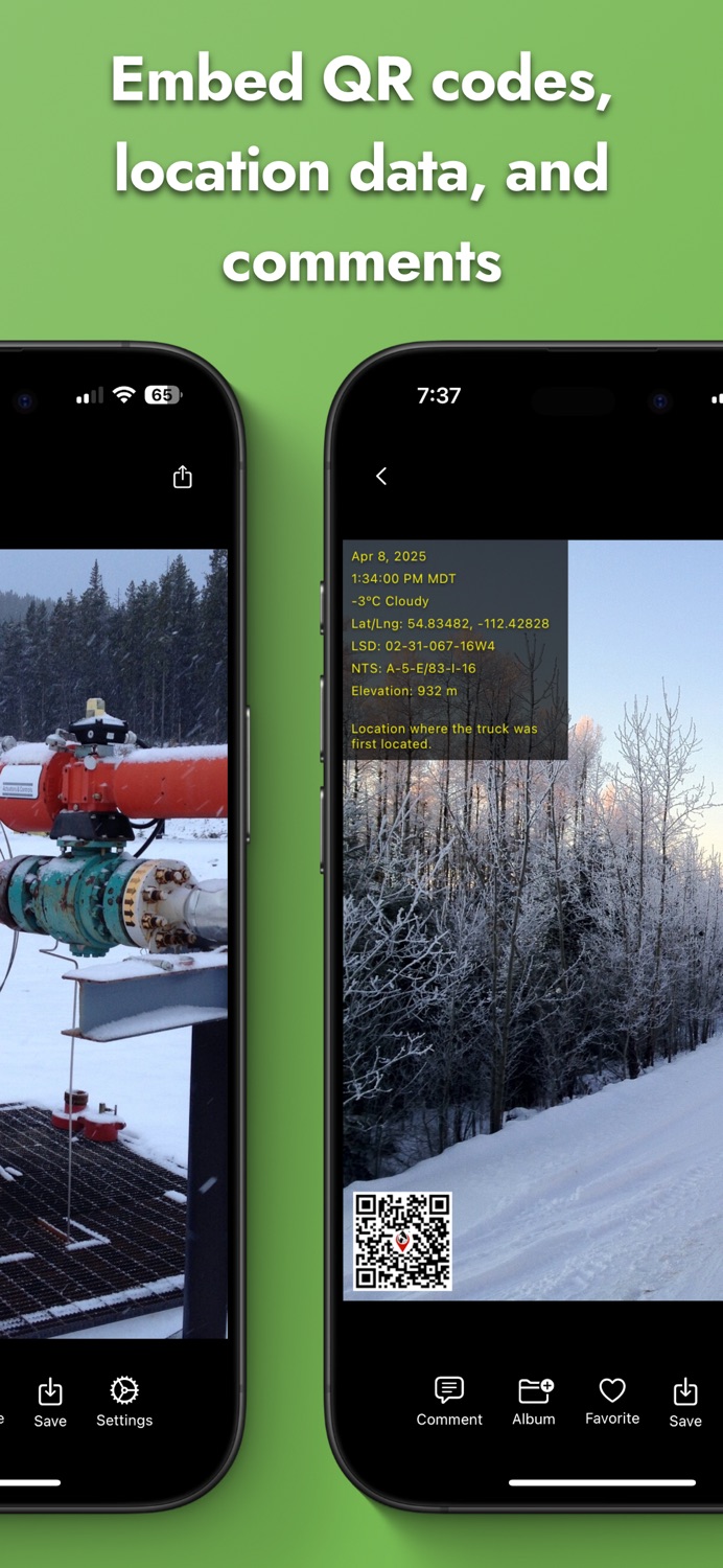
• Automatic stamping: date & time (with seconds + time zone), coordinates & QR code
• Custom overlays: customize the overlay, add comments or QR codes
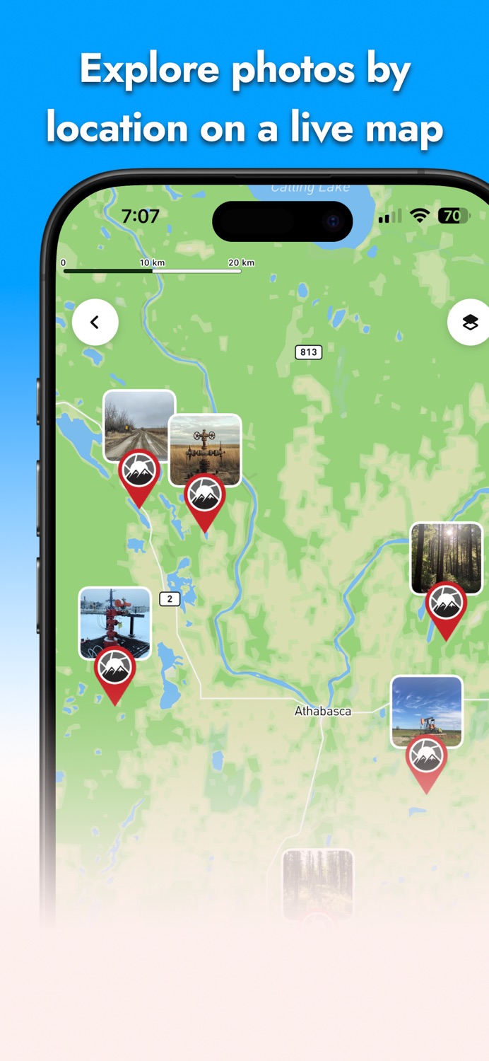
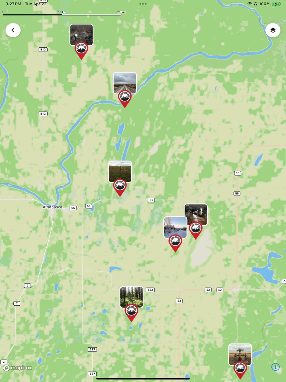
Explore on a full-screen map
• Interactive map view: browse pins, zoom, pan & tap thumbnails
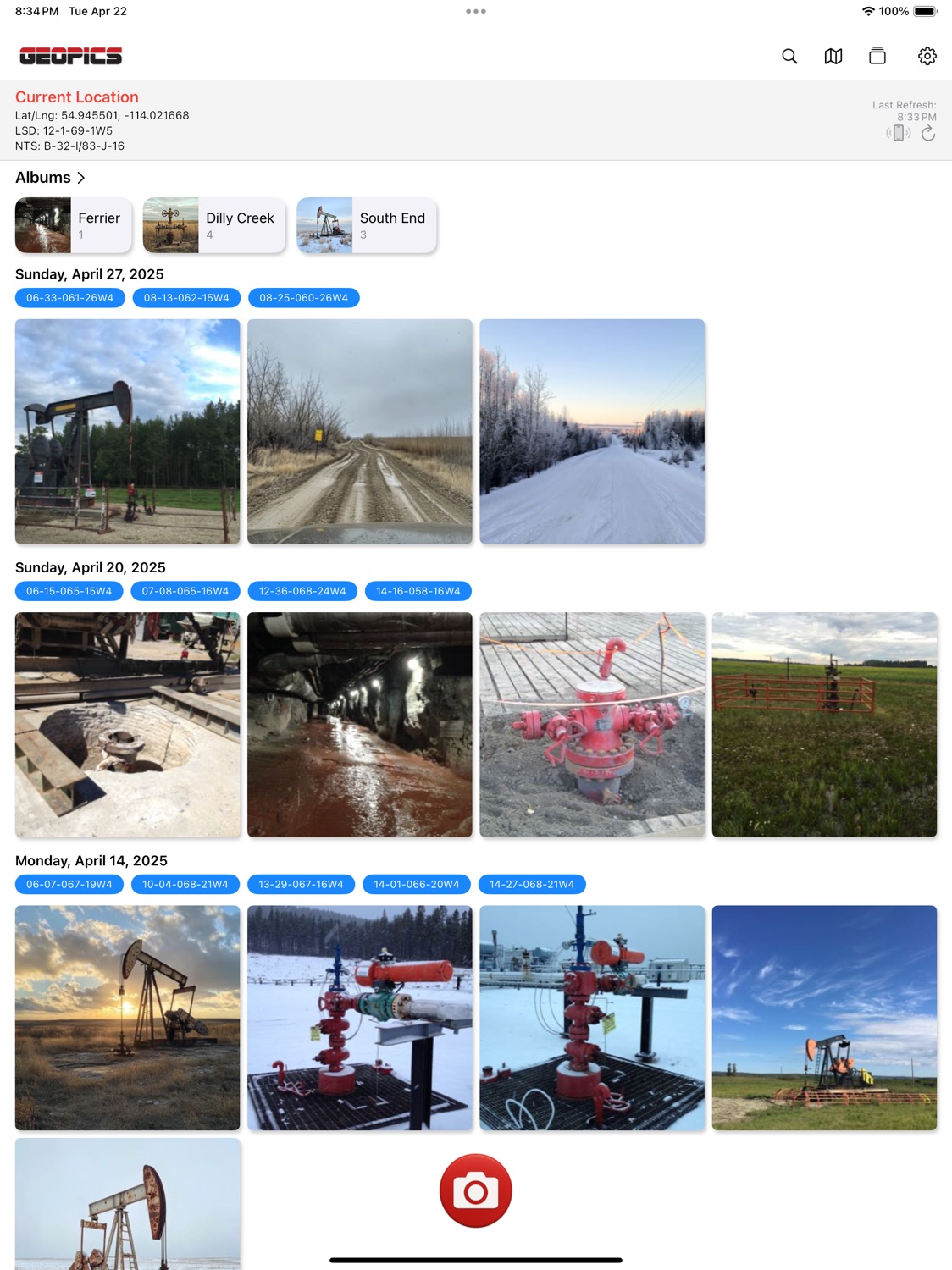
• All your coordinates: GPS, UTM, elevation—and in Western Canada, LSD & NTS
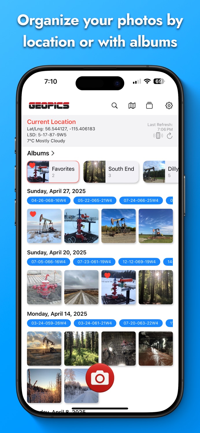
Organize & find your shots
• Dynamic albums: create, rename or reorder; album cover auto-selects its oldest photo
• Favorites: mark top shots and see them in a special “Favorites” album
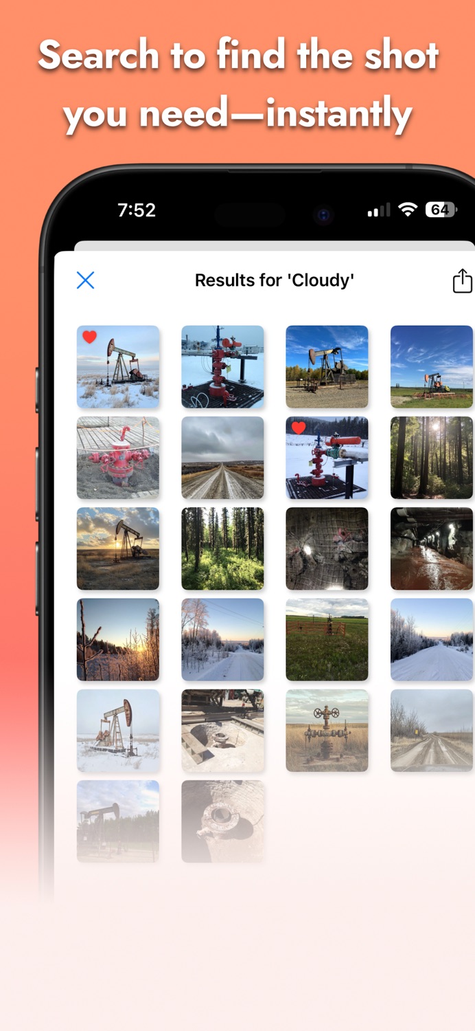
• Search the meta data and jump straight to filtered results
Comment & share instantly
• Add notes or tags post-capture
• Save to Photos or share via iMessage, SMS, Mail
Perfect for field engineers, surveyors, inspectors and outdoor photographers who need precise location data baked into every image.
Download GeoPics today and never lose track of where your photos were taken.
Information
Accessibility
ipadiphonemacrealityDevicetvoswatch
Version history · 17 recorded
2.3.027
2025-11-06
-Added Heading
-Added zoom selection buttons alongside the regular pinch to zoom
-Minor bug fixes
2.3.023
2025-08-01
Fixes
-Selecting a photo now always opens the correct image.
-Gallery updates instantly after deleting photos.
-Location data is now correctly included when sharing or saving images.
-Batch export and sharing now keep photos in the same order you see in the app.
-You can once again rotate your phone to view photos in landscape.
New Features
-Delete photos directly from the photo viewer with a confirmation prompt.
-Add comments to multiple photos at once when using multi‑select mode.
-Support for ultra‑wide (0.5x) zoom on devices with ultra‑wide cameras.
Improvements
-Smoother syncing between taking a photo and it appearing in the gallery.
-Better handling of errors during photo operations.
-Larger metadata overlay to display longer comments without covering the QR code.
2.3.022
2025-05-19
Complete overhaul!
• Built-in Geo-Camera: Flash toggle, gridlines and quality settings right in your capture view—tap once to stamp date, coords & QR code.
• Full-Screen Mapbox Map: Browse all your photos by location with smooth zoom, pan and tap-to-preview thumbnails.
• Dynamic Albums: Create, rename or reorder albums in a snap—each album cover auto-selects its oldest photo.
• Custom Metadata Overlays: Export images with QR codes, watermarks or your own labels baked in.
• Inline Search: Tap the search icon and jump straight to the shots you need.
• Favorites Album: Mark your top picks and find them in a dedicated “Favorites” album at the top.
• Western Canada Coordinates: Now includes LSD & NTS in addition to GPS, UTM and elevation.
• Performance & Stability: Under-the-hood optimizations for faster load times and smoother scrolling.
2.3.021
2025-05-08
Complete overhaul!
• Built-in Geo-Camera: Flash toggle, gridlines and quality settings right in your capture view—tap once to stamp date, coords & QR code.
• Full-Screen Mapbox Map: Browse all your photos by location with smooth zoom, pan and tap-to-preview thumbnails.
• Dynamic Albums: Create, rename or reorder albums in a snap—each album cover auto-selects its oldest photo.
• Custom Metadata Overlays: Export images with QR codes, watermarks or your own labels baked in.
• Inline Search: Tap the search icon and jump straight to the shots you need.
• Favorites Album: Mark your top picks and find them in a dedicated “Favorites” album at the top.
• Western Canada Coordinates: Now includes LSD & NTS in addition to GPS, UTM and elevation.
• Performance & Stability: Under-the-hood optimizations for faster load times and smoother scrolling.
2.3.020
2025-05-07
Complete overhaul!
• Built-in Geo-Camera: Flash toggle, gridlines and quality settings right in your capture view—tap once to stamp date, coords & QR code.
• Full-Screen Mapbox Map: Browse all your photos by location with smooth zoom, pan and tap-to-preview thumbnails.
• Dynamic Albums: Create, rename or reorder albums in a snap—each album cover auto-selects its oldest photo.
• Custom Metadata Overlays: Export images with QR codes, watermarks or your own labels baked in.
• Inline Search: Tap the search icon and jump straight to the shots you need.
• Favorites Album: Mark your top picks and find them in a dedicated “Favorites” album at the top.
• Western Canada Coordinates: Now includes LSD & NTS in addition to GPS, UTM and elevation.
• Performance & Stability: Under-the-hood optimizations for faster load times and smoother scrolling.
2.2.413
2023-10-31
Further enhanced offline LSD and NTS coordinate capabilities.
2.2.412
2023-10-30
Further enhanced offline LSD and NTS coordinate capabilities.
2.2.406
2023-08-07
Fixed a bug that caused a crash on iOS17 beta
2.2.403
2023-08-03
Minor bug fix
2.2.402
2023-08-02
Minor bug fixes.
2.2.401
2023-07-31
Bug Fixes.
2.2.400
2023-07-25
Minor bug fixes.
2.2.31
2023-07-20
Minor bug fixes.
2.2.3
2022-11-12
-Now the app caches the data, so it can load LSD locations almost instantly
-Location confirmation message only prompts the first time in a session
-LSD and GPS information is loaded and displayed on the map upon opening the app, long tap on it to select & copy the information
-Added the GPS data to the exported photos metadata
-Added a confirmation message if user tries to close photo without saving it
-Added the ability to copy/paste comments
2.2.2
2022-10-03
Minor bug fixes.
2.2.1
2022-09-21
Minor bug fixes.
2.2
2022-09-20
—
Listing history · 4 snapshots — every change kept with its date
releaseNotes
2026-06-21
-Added Heading
-Added zoom selection buttons alongside the regular pinch to zoom
-Minor bug fixes
description
2026-06-21
GeoPics transforms your iPhone into a geo-aware field camera—snap, stamp and share location-rich photos in seconds.
Snap geotagged photos in one tap
• Built-in geo-camera: live preview with flash, gridlines & GPS readou…
full text
GeoPics transforms your iPhone into a geo-aware field camera—snap, stamp and share location-rich photos in seconds. Snap geotagged photos in one tap • Built-in geo-camera: live preview with flash, gridlines & GPS readout • Automatic stamping: date & time (with seconds + time zone), coordinates & QR code • Custom overlays: customize the overlay, add comments or QR codes Explore on a full-screen map • Interactive map view: browse pins, zoom, pan & tap thumbnails • All your coordinates: GPS, UTM, elevation—and in Western Canada, LSD & NTS Organize & find your shots • Dynamic albums: create, rename or reorder; album cover auto-selects its oldest photo • Favorites: mark top shots and see them in a special “Favorites” album • Search the meta data and jump straight to filtered results Comment & share instantly • Add notes or tags post-capture • Save to Photos or share via iMessage, SMS, Mail Perfect for field engineers, surveyors, inspectors and outdoor photographers who need precise location data baked into every image. Download GeoPics today and never lose track of where your photos were taken.subtitle
2026-06-21
Take/Share Geo Stamped Photos
name
2026-06-21
GeoPics
Region availability · 1 of 1 storefronts
| Store | Price | Ratings | Avg | Version |
|---|---|---|---|---|
| US | Free | 0 | — | 2.3.027 |