Home › Photo & Video

 US
US
1 of 1 storefronts
Content in en-US
Content in en-US
Information
Preview 3 platforms
iPhone 10 images





iPad 8 images


Apple Watch 3 images


What’s New Version 9.0.0
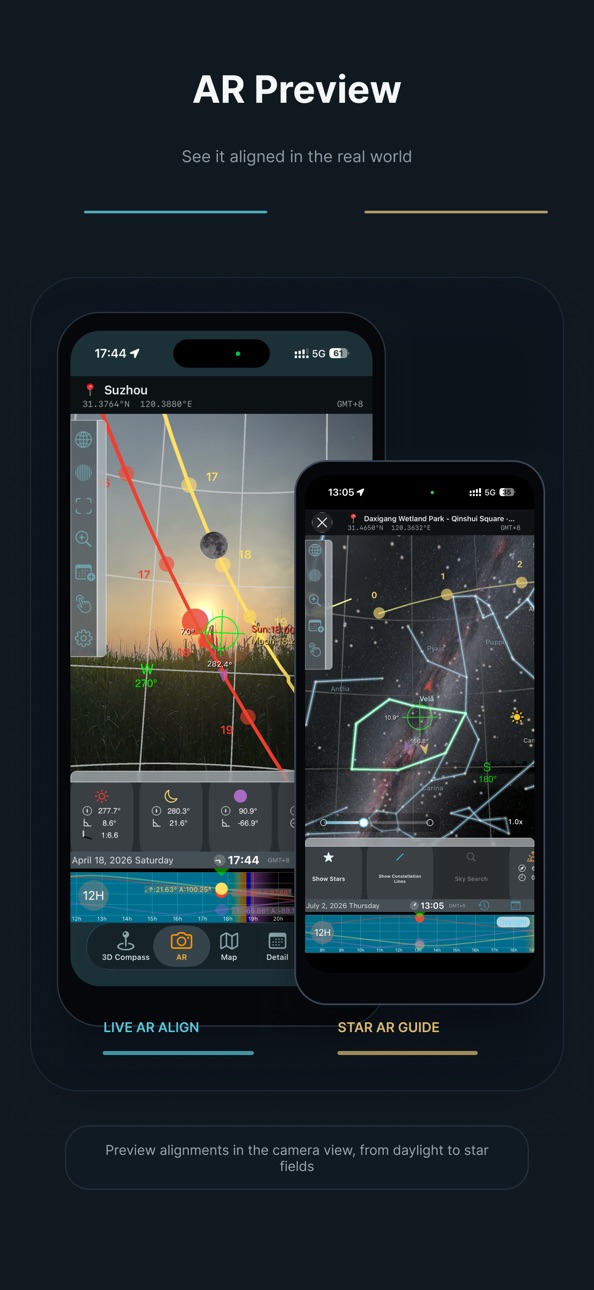
- Added the star chart feature, available in both AR and VR.
- Added a glow background for the 3D compass. You can enable it in Settings.
- Fixed known issues.
Description
Landscape Photography Helper Pro helps photographers understand and anticipate the alignment of time, light, and celestial motion behind great landscape images.
The real challenge is rarely pressing the shutter—it’s being in the right place, at the right time, facing the right direction.
Landscape Photography Helper Pro is a powerful photography planning tool that allows you to evaluate light and celestial conditions before heading out, so every shoot begins with clarity rather than guesswork.
You can use the timeline to preview the positions of the sun, moon, and Milky Way throughout the day. The 3D compass visualizes their direction and altitude in space, making light behavior intuitive instead of abstract data.
With AR mode, you can preview the future positions of celestial objects directly in your real environment and understand how they align with terrain and surroundings. The app also displays important astronomical events such as sunrise, sunset, golden hour, blue hour, and twilight, and allows you to add key moments to your system calendar for reminders.
The app provides an unlimited timeline, allowing you to predict celestial positions at any date and time. Advanced planning tools include star trail simulation, virtual viewfinder preview, sun and moon search, mountain identification, and comet position prediction.
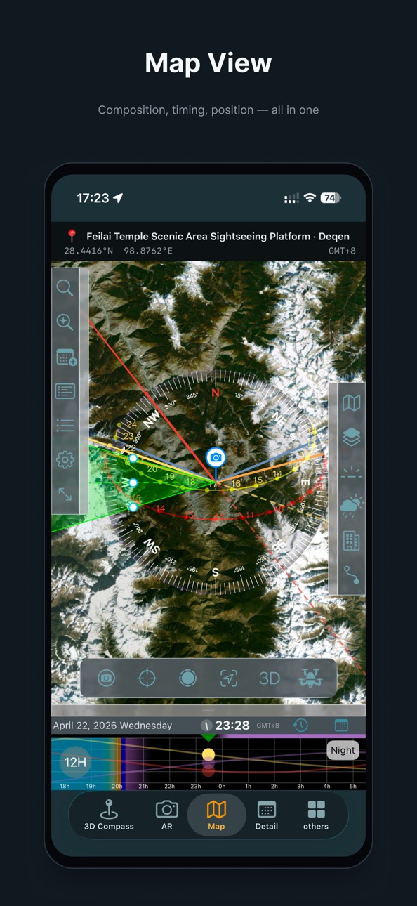
Comprehensive map planning tools allow you to evaluate shooting conditions at any location. You can view light pollution maps, weather forecasts, and save or reload shooting locations for future planning.
Landscape Photography Helper Pro also includes a professional-grade 3D VR terrain prediction system. Built on real elevation data and independent of on-site sensors, it provides stable and repeatable predictions anywhere.
You can simulate terrain occlusion, celestial paths, and real camera fields of view before arriving on location, helping you finalize compositions in advance.
The app also supports drone composition simulation within the same real 3D terrain environment.
You can simulate drone flight altitude and lens perspective before takeoff to verify whether an aerial composition works.
The system displays real AGL (Above Ground Level) altitude and horizontal distance to your intended composition point, helping you evaluate height constraints and flight feasibility during the planning stage. This feature assists with composition planning only and does not determine airspace legality or restricted flight zones.
An integrated drone database includes common consumer models and camera parameters, allowing simulations to more closely reflect real-world equipment performance.
The latest version also introduces building alignment planning.
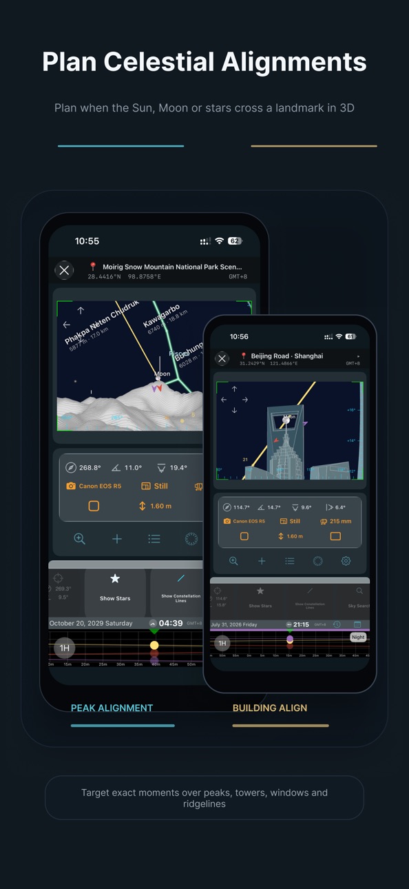
Built-in architectural models can be placed anywhere on the map, scaled to real dimensions, and rotated to match their real orientation. This allows you to plan precise alignments between celestial objects and buildings directly inside VR and drone simulation scenes.
You can also import custom .obj 3D models, allowing you to add your own landmarks and use them in planning scenes alongside built-in models.
Landscape Photography Helper Pro is not just a tool for viewing information—it is a tool for making decisions.
It helps you feel confident before shooting, calm on location, and efficient in creation.
Let great photographs be the result of preparation, not chance.
Privacy Statement:
https://www.landscapehelper.cn/privacy
License Agreement:
https://www.apple.com/legal/internet-services/itunes/dev/stdeula/
In-App Purchases US pricing
Official Model Library Subscription
(Monthly) · Monthly$0.99
(Yearly) · Yearly$3.99
Capabilities
In-App Purchases
Accessibility
ipadiphonemacrealityDevicetvoswatch
Version history 25 versions
Build 887679651v9.0.02026-07-03 20:27:59
- Added the star chart feature, available in both AR and VR.
- Added a glow background for the 3D compass. You can enable it in Settings.
- Fixed known issues.
Build 887439158v8.6.02026-06-25 18:03:21
This update includes several experience improvements and feature refinements:
- Added map connection lines, letting you link marked points and remove connection points for easier planning between shooting positions and targets.
- Improved iPad rotation and sidebar layouts, with better display behavior in AR, VR, and related pages.
- Refined VR viewfinding and camera height controls, with clearer composition guide icons.
- Improved wording and menu icons for camera positions, shooting targets, and shooting plans for a more consistent workflow.
- Added saved shooting targets and QR code import, and improved saved-place lists and forms.
- Added iCloud sync support for Core Data and user models.
- Simplified the zoomable AR interface by removing an unnecessary settings entry.
- Fixed multilingual translations such as “Altitude” for more accurate Sun/Moon search results and related information.
- Fixed several layout and detail issues to improve stability and usability.
Build 886973005v8.5.02026-06-15 12:08:39
1. Added the Official Model Library. With a subscription, you can use officially placed building models in VR and drone simulation for alignment, composition, and shot planning.
2. Added zoom and exposure compensation sliders to the variable-zoom AR page for more flexible framing and previewing.
3. Added a zoom slider to the map page for easier view adjustment.
4. Added support for receiving shooting plans and model instances from Landscape Helper for Mac. The Mac app is sold separately and may become available after review; it makes desktop planning easier and lets you sync plans and placed model instances to iOS quickly by scanning a QR code.
Build 886043199v8.0.02026-05-23 17:07:57
1. Variable-zoom AR support
AR now supports smooth, continuous zoom. You can frame and predict at any focal length supported by your device, making it easier to judge the positions of the Sun, Moon, Milky Way, and other targets with greater precision and in a way that better matches your real shooting composition.
2. Apple Watch support
Landscape Photography Helper Pro now supports Apple Watch, giving you a lighter and faster way to check key information in the field.
The Apple Watch version currently includes three pages:
2D Compass
View the real-time directions of the Sun, Moon, and Galactic Center on your watch, along with today's sunrise, sunset, moonrise, and moonset directions.
The 2D Compass on Apple Watch can also guide you to the shooting position currently set on your iPhone, making outdoor scouting and on-site adjustments easier.
Today's Special Moments
Quickly check the start times of important special moments for the day, helping you stay on top of key shooting windows.
Today's Moon Phase
Check the current moon phase without opening the main app, useful for Moon, Milky Way, and nightscape photography.
Apple Watch support is designed to help you access key information quickly on location, as a companion experience to the main iPhone / iPad app. For complete shooting plans, precise predictions, and complex scene planning, we still recommend using the main app.
3. Experience improvements and bug fixes
Improved parts of the user experience and fixed several known issues.
Build 885353376v7.8.02026-05-07 16:48:10
· Added automatic search for alignment shooting locations.
· Improved terrain loading speed.
Build 884795498v7.7.02026-04-25 03:53:01
* Tap detail cards to show or hide celestial objects
* Added second-level precision to the timeline
* Added meteor shower list to the details page
* Added radiant position prediction for meteor showers
* Improved comet prediction experience
* Timeline now supports meteor shower radiants and comet paths
* Various improvements and bug fixes
Build 884217990v7.6.02026-04-07 16:56:22
• Added solar and lunar eclipse predictions to the detail view
• Added field of view overlay on the map
• Added camera parameters display on the map
• Fixed occasional display issues in immersive mode on the map
• Fixed missing elements when switching map providers
• Improved peak labels rendering
• Improved building model rendering
• Improved moon rendering across 3D scenes
• UI improvements for the detail view
• Various bug fixes and stability improvements
Build 883604820v7.5.02026-03-21 17:14:04
Fixed an issue that could cause unexpected app termination on iOS 15 due to Google Maps compatibility, and improved overall stability.
Build 883118943v7.0.12026-03-16 02:23:25
Added on-site trace recording to help locate buildings that are not clearly visible on satellite maps.
Fixed an issue where the daily trajectories of the Sun, Moon, and Milky Way were not updated correctly when crossing days while dragging the timeline in AR mode.
Build 883058581v7.0.02026-03-06 17:27:28
New: Plan Celestial Alignments with Buildings
This update introduces a powerful new way to plan celestial photography. Dozens of built-in building models are now available. Place them anywhere on the map, scale them to real-world dimensions, and rotate them to match their real orientation. You can now plan precise alignments between celestial objects and buildings directly in VR and drone simulation scenes.
New: Import Your Own 3D Models
You can now import custom .obj models into the app. Imported models appear alongside the built-in library and can be used for your own landmark alignment planning.
VR Mode Improvements
• Move the camera forward, backward, left, or right for precise position adjustment
• New azimuth and altitude rulers in the VR preview for more accurate alignment planning
Other Improvements
• Various usability improvements and optimizations
Build 882555988v6.9.12026-02-18 22:30:41
• Fixed stability issues related to the drone simulation module.
• Performance improvements.
Build 882004110v6.9.02026-01-30 18:58:28
• New Drone View Simulation
Preview drone compositions in a realistic 3D terrain scene before flying.
• Flight risk awareness
• Real-time AGL (Above Ground Level) display
• Helps evaluate height-related risks for a given composition
• Distance & endurance estimation
View the horizontal distance to your target to judge flight feasibility.
• Device-based simulation
Built-in drone database covering common consumer models and cameras.
Build 881800146v6.1.12026-01-24 20:17:01
Fixed an issue that could occur when opening the detail page without location permission, improving overall stability.
Build 881743258v6.1.02026-01-22 17:04:16
1. New Timelapse Simulation
Before pressing the shutter, you can now fully preview a timelapse shoot in advance:
• Determine shooting interval, total frames, and final video duration
• Preview the pacing and visual progression of the final timelapse
This helps you make better decisions before or during shooting, avoiding situations where the final video feels too short, lacks frames, or the motion is not smooth enough.
2. Sun & Moon Alignment Lines on Map
Sun and Moon alignment directions are now displayed directly on the map, making it easier to find locations where they align with mountains or terrain.
3. Improved Map Button Layout
Optimized the layout of map controls for easier operation of camera positions and shooting targets.
4. New Immersive Map Mode
An immersive mode has been added to expand the map view, reduce UI distractions, and help you focus on location selection and composition.
5. Stability Improvements
Fixed a crash that could occur in certain situations.
Build 881409749v6.0.02026-01-13 00:14:13
• A fully refined UI with improved visual consistency and overall polish.
• Added Supermoon prediction, now available in the Details view.
• New option to manually select time zones.
• Introduced a 12-hour timeline mode.
• Bug fixes and overall performance improvements.
Build 880964444v5.0.02026-01-02 21:43:12
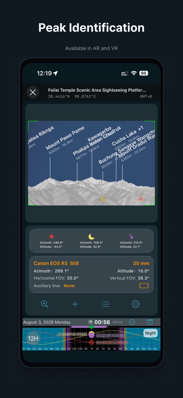
• Added Mountain Identification in both AR and VR. When enabled, mountain names, elevations, and distances are displayed.
• Added Comet Position Visualization in both AR and VR.
• Improved the scrolling experience of the time timeline.
• Enhanced VR performance and smoothness.
• Refined wording and descriptions across multiple languages.
Build 880429641v4.0.02025-12-09 16:06:10
Introducing the new 3D VR Terrain Prediction System
This update brings a professional-grade 3D terrain prediction feature. Unlike AR modes that rely on sensors and the surrounding environment, the 3D scene is powered by real terrain data, providing stable, accurate, and reproducible composition planning anytime and anywhere—all before you reach the location.
• More accurate than AR: Simulates mountain occlusion, celestial positions, and light paths based on real elevation models, free from device attitude or magnetic interference.
• True camera simulation: Renders the field of view according to your selected camera model and focal length, helping you preview the exact composition you will capture on-site.
• Composition & orientation tools: Composition guides, center point, target markers, and one-tap view switching to the Sun, Moon, Galactic Center, or any target.
• Sun and Moon visualization: Precisely displays trajectories and azimuth/altitude angles for better light evaluation.
• Configurable terrain loading: Load larger or more detailed areas as needed.
• Smooth 3D interaction: Optimized rendering for fluid zooming, panning, and rotation.
A powerful planning tool designed for landscape and astrophotography, enabling precise predictions of composition, light, and terrain relationships.
Build 879820343v3.7.22025-12-06 05:38:29
• Fix the problem of map positioning deviation.
• Performance optimization and multiple stability improvements.
Build 878315475v3.7.12025-09-22 04:50:55
Urgently fix the problem that the AR tab may be in the wrong direction.
Build 878146815v3.7.02025-09-16 05:05:42
Adapted for iOS 26.
Build 878065141v3.6.92025-09-15 22:35:17
Fix the issue where the date label is obscured in certain situations.
Build 877431176v3.6.82025-08-21 05:01:38
· New function of "Add current time to calendar"
Build 875837303v3.6.72025-07-30 07:56:06
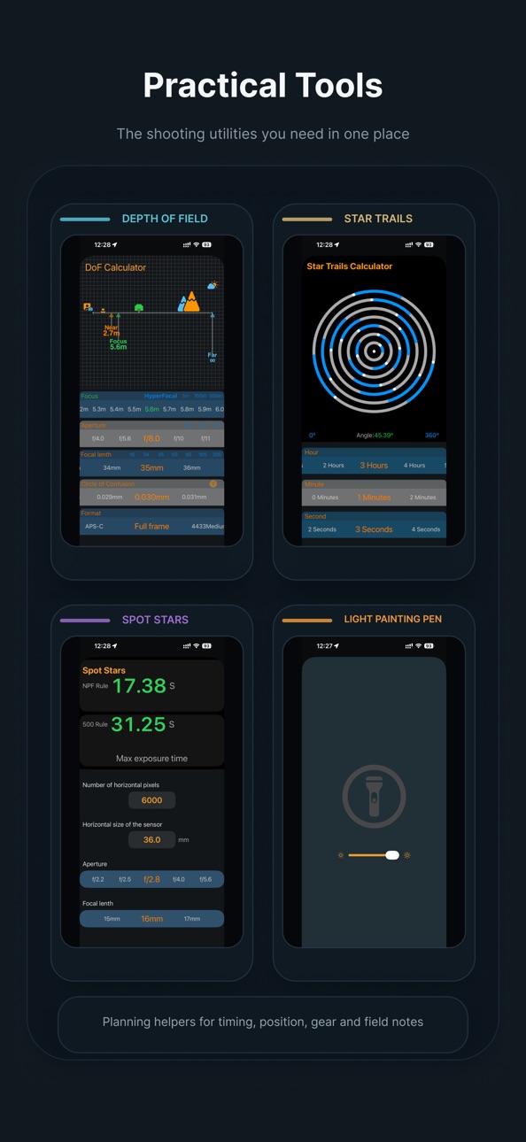
1. New shortcut buttons for commonly used focal segments such as 35, 85 have been added to the depth of field calculator.
2. Fix known problems and optimize user experience.
Build 875600394v3.6.62025-06-16 08:51:01
Fixed a bug in a utility.
Build 875569251v3.6.52025-06-14 12:23:26
Fix a bug that may cause the subscription to be unavailable.
Price history by region
Currency
Show
Columns
Search
Availability 1 of 1 storefronts
| Region | Language | Price | Ratings | Avg | Version |
|---|---|---|---|---|---|
| US | en-US | USD 9.99 | 3 | 3.7 | 9.0.0 |
Change log 29 changes · US
✎
releaseNotes updated
- Added the star chart feature, available in both AR and VR.
- Added a glow background for the 3D compass. You can enable it in Settings.
- Fixed known issues.
✎
description updated
Landscape Photography Helper Pro helps photographers understand and anticipate the alignment of time, light, and celestial motion behind great landscape images.
✎
subtitle updated
Sun Moon Milkyway Prediction
✎
name updated
LandscapePhotographyHelper Pro
◆
Version 9.0.0 released
- Added the star chart feature, available in both AR and VR.
- Added a glow background for the 3D compass. You can enable it in Settings.
- Fixed known issues.
◆
Version 8.6.0 released
This update includes several experience improvements and feature refinements:
- Added map connection lines, letting you link marked points and remove connection points for easier planning between shooting positions and targets.
- Improved
◆
Version 8.5.0 released
1. Added the Official Model Library. With a subscription, you can use officially placed building models in VR and drone simulation for alignment, composition, and shot planning.
2. Added zoom and exposure compensation sliders to the variabl
◆
Version 8.0.0 released
1. Variable-zoom AR support
AR now supports smooth, continuous zoom. You can frame and predict at any focal length supported by your device, making it easier to judge the positions of the Sun, Moon, Milky Way, and other targets with greate
◆
Version 7.8.0 released
· Added automatic search for alignment shooting locations.
· Improved terrain loading speed.
◆
Version 7.7.0 released
* Tap detail cards to show or hide celestial objects
* Added second-level precision to the timeline
* Added meteor shower list to the details page
* Added radiant position prediction for meteor showers
* Improved comet prediction experience
◆
Version 7.6.0 released
• Added solar and lunar eclipse predictions to the detail view
• Added field of view overlay on the map
• Added camera parameters display on the map
• Fixed occasional display issues in immersive mode on the map
• Fixed missing element
◆
Version 7.5.0 released
Fixed an issue that could cause unexpected app termination on iOS 15 due to Google Maps compatibility, and improved overall stability.
◆
Version 7.0.1 released
Added on-site trace recording to help locate buildings that are not clearly visible on satellite maps.
Fixed an issue where the daily trajectories of the Sun, Moon, and Milky Way were not updated correctly when crossing days while dragging
◆
Version 7.0.0 released
New: Plan Celestial Alignments with Buildings
This update introduces a powerful new way to plan celestial photography. Dozens of built-in building models are now available. Place them anywhere on the map, scale them to real-world dimensions
◆
Version 6.9.1 released
• Fixed stability issues related to the drone simulation module.
• Performance improvements.
◆
Version 6.9.0 released
• New Drone View Simulation
Preview drone compositions in a realistic 3D terrain scene before flying.
• Flight risk awareness
• Real-time AGL (Above Ground Level) display
• Helps evaluate height-related risks for a given composition
•
◆
Version 6.1.1 released
Fixed an issue that could occur when opening the detail page without location permission, improving overall stability.
◆
Version 6.1.0 released
1. New Timelapse Simulation
Before pressing the shutter, you can now fully preview a timelapse shoot in advance:
• Determine shooting interval, total frames, and final video duration
• Preview the pacing and visual progression of the fina
◆
Version 6.0.0 released
• A fully refined UI with improved visual consistency and overall polish.
• Added Supermoon prediction, now available in the Details view.
• New option to manually select time zones.
• Introduced a 12-hour timeline mode.
• Bug fixes and ove
◆
Version 5.0.0 released
• Added Mountain Identification in both AR and VR. When enabled, mountain names, elevations, and distances are displayed.
• Added Comet Position Visualization in both AR and VR.
• Improved the scrolling experience of the time timeline.
◆
Version 4.0.0 released
Introducing the new 3D VR Terrain Prediction System
This update brings a professional-grade 3D terrain prediction feature. Unlike AR modes that rely on sensors and the surrounding environment, the 3D scene is powered by real terrain data,
◆
Version 3.7.2 released
• Fix the problem of map positioning deviation.
• Performance optimization and multiple stability improvements.
◆
Version 3.7.1 released
Urgently fix the problem that the AR tab may be in the wrong direction.
◆
Version 3.7.0 released
Adapted for iOS 26.
◆
Version 3.6.9 released
Fix the issue where the date label is obscured in certain situations.
◆
Version 3.6.8 released
· New function of "Add current time to calendar"
◆
Version 3.6.7 released
1. New shortcut buttons for commonly used focal segments such as 35, 85 have been added to the depth of field calculator.
2. Fix known problems and optimize user experience.
◆
Version 3.6.6 released
Fixed a bug in a utility.
◆
Version 3.6.5 released
Fix a bug that may cause the subscription to be unavailable.