Home › Productivity

 US
US
1 of 1 storefronts
Content in en-US
Content in en-US
Information
Preview 2 platforms
iPhone 8 images




iPad 8 images



What’s New Version 2.0.3
Minor bug fixes with satellite track display on exported PDF
Description
GNSS Obs - Professional Observation Logs
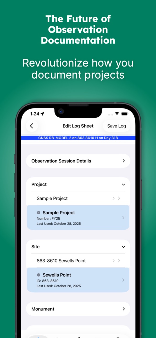
GNSS Obs is the professional solution for documenting static GNSS observations. Designed for surveyors, geodesists, and geospatial professionals, it eliminates transcription errors and ensures consistent, accurate project documentation.
Replace Paper Logs with Digital Precision
Stop relying on paper forms, fillable PDFs, and handwritten notes. GNSS Obs provides a structured workflow that promotes accuracy and completeness while maintaining the professional standards required for geodetic control projects.
Comprehensive Equipment Management
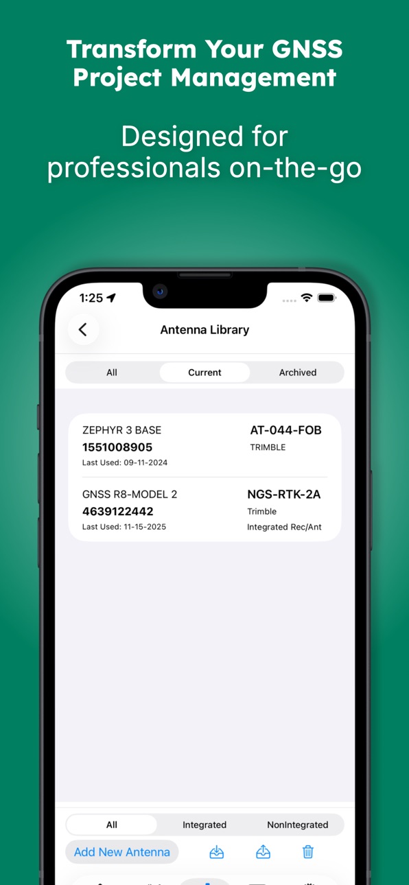
Build and maintain your equipment library with support for:
• Fixed height, collapsible and adjustable tripods
• Antenna extensions
• Integrated antenna/receiver configurations
• Complete metadata for NGS compliance
Import and export library items to share standardized configurations across your organization.
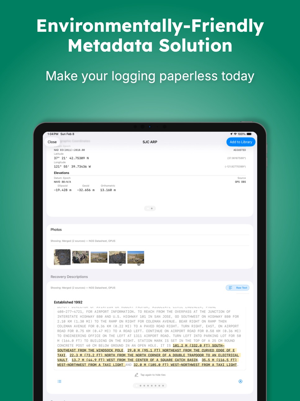
Direct NGS Database Integration
Access public monument data directly from:
• National Geodetic Survey Integrated Database (IDB)
• OPUS Share Database
• NOAA CO-OPS Stations
Monuments can also be entered manually when working with local control networks.
OPUS Solution Integration
Import OPUS solution emails to automatically populate:
• Observed positions
• Actual observation times
• Session statistics
• Solution quality metrics
Include the complete OPUS solution in your PDF output for comprehensive project records.
Essential Field Tools
• Session timers with local notifications
• Automatic weather recording at session start and end
• Photo documentation with NGS-compliant naming
• Satellite visibility diagrams using device motion sensors
• Real-time editing before, during, and after observations
Professional Documentation
Export publication-ready PDF observation logs featuring:
• Your company logo and branding
• Complete equipment configurations
• Weather conditions
• Site photographs
• Visibility diagrams
• OPUS solutions
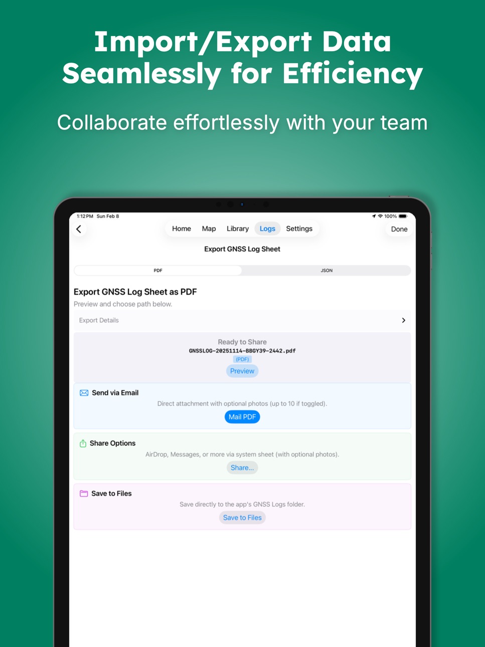
Share via Files, email, AirDrop, or messaging.
Note: This app documents observations and does not communicate with GNSS receivers. It is designed as a field companion for recording session metadata and producing professional deliverables.
Privacy First
All data remains on your device. No account required. Full control over exports and backups.
Terms of Use (EULA): https://www.apple.com/legal/internet-services/itunes/dev/stdeula/
Accessibility
ipadiphonemacrealityDevicetvoswatch
Version history 17 versions
Build 884957703v2.0.32026-04-27 18:50:45
Minor bug fixes with satellite track display on exported PDF
Build 884436593v2.0.22026-04-14 20:35:33
Fixed some bugs in the visibility views that may cause the app to bog down. Also added a toggle to the pdf export so you can add photos without having to go back the settings page.
Build 882276258v2.0.12026-02-23 03:25:26
What's New in Version 2.0.1
This major update enhances field workflows, mapping capabilities, and OPUS integration based on feedback from surveying professionals.
Enhanced Satellite Visibility Diagrams
• Satellite tracks now displayed during observation periods
• Completely revised VQ rating algorithm with improved accuracy
Streamlined Photo Documentation
• Redesigned photo import and naming workflow
• Attach photos directly to PDF export emails
• Improved rotation, metadata handling, and reordering
Improved OPUS Integration
• Import OPUS email and xml solution files
• Smart merging with conflict detection and warnings
• Enhanced solution tables with difference calculations
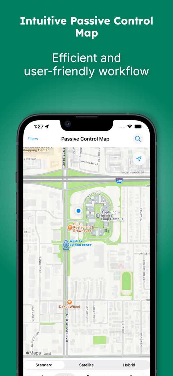
Professional Passive Control Map Interface
• Interactive monument search with real-time filtering
• Custom filter presets: GNSS Horizontal Control, Geodetic Leveling, Airport AC16, Tidal/Water Level, NSRS Tie, and more
• Enhanced monument symbols with quality indicators
• Get directions to monuments via Apple Maps
• Reference tie extraction from published descriptions
Equipment Library Enhancements
• Adjustable leg tripod support with custom height validation
• In-use equipment detection with visual indicators
• Full-screen library views with multi-select capabilities
• Export and import complete observation logs for backup and sharing
Workflow Improvements
• Refined navigation with smoother transitions
• Scheduled vs. actual observation time tracking
• Session notifications for completed observations
• Import/Export individual Observation Logs
PDF Export Updates
• Multi-page support with attachment toggles
• Revised Visibility diagrams with dashed satellite tracks
• Tripod type display (Fixed/Collapsible/Adjustable)
• Photo attachment options for complete documentation
Technical Improvements
• Enhanced performance
• Improved monument proximity detection and merging
• Better handling of large equipment libraries
Build 870741623v1.4.62024-11-28 00:58:32
This version fixes a few minor bugs and updates the code for the new iOS releases. The target release for this build is iOS 17.6, and has been tested with iOS 18.1.1
Build 864626999v1.4.42024-03-25 11:05:58
This version fixed some small bugs and was built to work with iOS 17.0
Build 858288220v1.4.32023-07-06 11:24:35
Change Log V1.4.3
If you are new to the app, go to the library and load sample data. This will give you some items to experiment with.
Improvements to confirmations and alerts.
Added Pull to refresh to Home page and summary page
Changed the naming to match the current OPUS Project naming convention 4CID-DOY-Start-Year. This will only apply if four character ID are enabled in the project. This is build 15, for iOS 16.2
For support, contact support@gnsslogapp.com
Build 854980088v1.4.22023-02-20 18:26:27
Change Log V1.4.2
If you are new to the app, go to the library and load sample data. This will give you some items to experiment with.
Bug fixes and format improvements.
For support, contact support@gnsslogapp.com
Build 853687785v1.4.12022-12-03 15:34:01
Change Log V1.4.1
If you are new to the app, go to the library and load sample data. This will give you some items to experiment with.
This version 1.4.1 is designed for iOS16
This version now retrieves weather information from Apple Weather. The weather data location is based on the published or preliminary coordinates of the chosen monument. If the monument does not have a location, the weather table will not be available. You can always edit the coordinates or use the device location to store preliminary coordinates by editing the monument in the library.
This version also contains improvements and housecleaning based on the new iOS release.
For support, contact support@gnsslogapp.com
Build 851112944v1.3.82022-07-26 20:05:39
Change Log V1.3.8
If you are new to the app, go to the library and load sample data. This will give you some items to experiment with.
This version corrected some minor bug fixes to pick list logic
For support, contact support@gnsslogapp.com
Build 850888509v1.3.72022-07-17 11:51:11
Change Log V1.3.7
If you are new to the app, go to the library and load sample data. This will give you some items to experiment with. A user manual is included in the Help at the bottom of the settings page
Added a delete button to the library item lists. This will remove all library items that are not attached to a observation log
Changed the sort method for displaying monuments to sort by designation
Imported items will now be automatically archived. They will need to be edited to switch off the unarchive button to be displayed in the pick lists.
The PDF output is now automatically named.
Added a dimple depth measurement field to the monument record. Dimple depths are enabled in the project.
The above changes are reflected in the user manual
Other little tweaks and bug fixes
For support, contact support@gnsslogapp.com
Build 850552634v1.3.62022-07-02 00:41:08
Change Log V1.3.6
Added some support in the monument record for 4CIDs when defined by the project
Named the output file when sharing the PDF
Other little tweaks and bug fixes
For support, contact support@gnsslogapp.com
Build 848740064v1.3.52022-05-01 22:39:53
Change Log V1.3.5
If you are new to the app, go to the library and load sample data. This will give you some items to experiment with.
Refined when using the user location for observed coordinates and when creating or editing a monument. Added a standard deviation of the device location. Buttons for using the device location will appear after enough locations have been stored to calculate a standard deviation.
Fixed a bug in the visibility diagram to show the no-fly area of GPS satillites correctly with southern latitudes. This bug was incorrectly shading the visibility diagram and would occasionally cause a program crash.
Added some verification to the inputted published coordinates to filter to only numbers and restrict the latitude to +- 45 degrees and longitude to +-180 degrees.
Added vertical and horizontal datum fields to the new and edit monument library pages.
Edited the user manual to reflect the above changes.
For support, contact support@gnsslogapp.com
Build 848445140v1.3.42022-04-20 17:39:01
Change Log V1.3.4
If you are new to the app, go to the library and load sample data. This will give you some items to experiment with.
Made changes to the user manual
Allowed the app to use information from the receiver when the antenna is not integrated.
The OPUS import will update the observation date to the actual start
Added a remove OPUS solution button to the Edit Log page
For support, contact support@gnsslogapp.com
Build 848387644v1.3.32022-04-17 07:50:30
Welcome to Version 1.3.3
Changed to allow the app to automatically name the log from the Antenna Name if the antenna is an integrated antenna/receiver
Allowed the OPUS import to change the observation date to match the solution
In-app subscriptions will be for future premium features.
Build 848074865v1.3.22022-04-02 19:20:33
Welcome to Version 1.3.2
If you are new to the app, go to the library and load sample data. This will give you some items to experiment with.
Added some updates to the users manual
Minor bug and spelling corrections
Build 847973879v1.3.12022-03-29 12:35:24
Welcome to Version 1.3.1
If you are new to the app, go to the library and load sample data. This will give you some items to experiment with.
Fixed a bug with the weather data when observation logs are active.
Build 840592602v1.2.82022-03-26 09:32:08
No pricing data captured yet — comparisons appear once the app has paid storefronts or in-app purchases.
Availability 1 of 1 storefronts
| Region | Language | Price | Ratings | Avg | Version |
|---|---|---|---|---|---|
| US | en-US | Free | 16 | 4.9 | 2.0.3 |
Change log 21 changes · US
✎
releaseNotes updated
Minor bug fixes with satellite track display on exported PDF
✎
description updated
GNSS Obs - Professional Observation Logs
GNSS Obs is the professional solution for documenting static GNSS observations. Designed for surveyors, geodesists, an
✎
subtitle updated
GNSS Static Observation Log
✎
name updated
GNSS Log App
◆
Version 2.0.3 released
Minor bug fixes with satellite track display on exported PDF
◆
Version 2.0.2 released
Fixed some bugs in the visibility views that may cause the app to bog down. Also added a toggle to the pdf export so you can add photos without having to go back the settings page.
◆
Version 2.0.1 released
What's New in Version 2.0.1
This major update enhances field workflows, mapping capabilities, and OPUS integration based on feedback from surveying professionals.
Enhanced Satellite Visibility Diagrams
• Satellite tracks now displayed dur
◆
Version 1.4.6 released
This version fixes a few minor bugs and updates the code for the new iOS releases. The target release for this build is iOS 17.6, and has been tested with iOS 18.1.1
◆
Version 1.4.4 released
This version fixed some small bugs and was built to work with iOS 17.0
◆
Version 1.4.3 released
Change Log V1.4.3
If you are new to the app, go to the library and load sample data. This will give you some items to experiment with.
Improvements to confirmations and alerts.
Added Pull to refresh to Home page and summary page
Changed
◆
Version 1.4.2 released
Change Log V1.4.2
If you are new to the app, go to the library and load sample data. This will give you some items to experiment with.
Bug fixes and format improvements.
For support, contact support@gnsslogapp.com
◆
Version 1.4.1 released
Change Log V1.4.1
If you are new to the app, go to the library and load sample data. This will give you some items to experiment with.
This version 1.4.1 is designed for iOS16
This version now retrieves weather information from Apple We
◆
Version 1.3.8 released
Change Log V1.3.8
If you are new to the app, go to the library and load sample data. This will give you some items to experiment with.
This version corrected some minor bug fixes to pick list logic
For support, contact support@gnsslogapp
◆
Version 1.3.7 released
Change Log V1.3.7
If you are new to the app, go to the library and load sample data. This will give you some items to experiment with. A user manual is included in the Help at the bottom of the settings page
Added a delete button to the l
◆
Version 1.3.6 released
Change Log V1.3.6
Added some support in the monument record for 4CIDs when defined by the project
Named the output file when sharing the PDF
Other little tweaks and bug fixes
For support, contact support@gnsslogapp.com
◆
Version 1.3.5 released
Change Log V1.3.5
If you are new to the app, go to the library and load sample data. This will give you some items to experiment with.
Refined when using the user location for observed coordinates and when creating or editing a monument.
◆
Version 1.3.4 released
Change Log V1.3.4
If you are new to the app, go to the library and load sample data. This will give you some items to experiment with.
Made changes to the user manual
Allowed the app to use information from the receiver when the antenna
◆
Version 1.3.3 released
Welcome to Version 1.3.3
Changed to allow the app to automatically name the log from the Antenna Name if the antenna is an integrated antenna/receiver
Allowed the OPUS import to change the observation date to match the solution
In-app su
◆
Version 1.3.2 released
Welcome to Version 1.3.2
If you are new to the app, go to the library and load sample data. This will give you some items to experiment with.
Added some updates to the users manual
Minor bug and spelling corrections
◆
Version 1.3.1 released
Welcome to Version 1.3.1
If you are new to the app, go to the library and load sample data. This will give you some items to experiment with.
Fixed a bug with the weather data when observation logs are active.
◆
Version 1.2.8 released