Home › Navigation

 US
US
USen-US MXes-MX
 BRpt-BR
 ITit
ITit CHde-CH
 AUen-AU
 INen-GB
 ZAen-GB
 PLen-GB
 PHen-GB
 CZen-GB
 LTen-GB
 FIen-GB
 GHen-GB
 ISen-GB
 JPja
JPja TNen-GB
 AFen-GB
 AIen-GB
 ALen-GB
 AOen-GB
 BBen-GB
 BFen-GB
 BJen-GB
 BMen-GB
 BSen-GB
 BWen-GB
 CIfr-FR
 CMfr-FR
 CVen-GB
 CYen-GB
 DMen-GB
 GDen-GB
 GMen-GB
 GWen-GB
 KEen-GB
 KNen-GB
 KWen-GB
 KYen-GB
 LRen-GB
 LYen-GB
 MDen-GB
 MKen-GB
 MLen-GB
 MOzh-Hant-HK
 MSen-GB
 MTen-GB
 MUen-GB
 MWen-GB
 MZen-GB
 NAen-GB
 NGen-GB
 NRen-GB
 PGen-GB
 PKen-GB
 RWen-GB
 SBen-GB
 SCen-GB
 SLen-GB
 SNen-GB
 STen-GB
 SZen-GB
 TCen-GB
 TTen-GB
 TZen-GB
 UGen-GB
 VCen-GB
 VGen-GB
 ZMen-GB
 ZWen-GB
70 of 70 storefronts
Content in en-US
Content in en-US
Information
Preview 2 platforms
iPhone 10 images



iPad 8 images


What’s New Version 1.33.2
• Fixed track visibility issue on certain offline map styles
• Changed default offline map style to Outdoors
Description
EXPLORE DEEPER. NAVIGATE SMARTER. RELIVE EVERY ADVENTURE.
Do you have GPX or KML tracks you love? Or are you ready to head into the mountains and record your next journey? GPX Viewer PRO transforms your iPhone and iPad into a powerful outdoor companion — whether you're hiking, biking, or exploring new terrain. From planning routes to analyzing every detail of your trip, everything you need is right in your pocket.
BRING YOUR ROUTES TO LIFE
Import your GPX and KML files in seconds and instantly visualize them on beautiful, detailed maps.
• View multiple tracks, routes, and waypoints at once
• Explore past adventures or discover new ones
• Customize colors and styles to match your journey
UNDERSTAND EVERY STEP YOU TAKE
Go beyond just tracking — analyze and improve your performance.
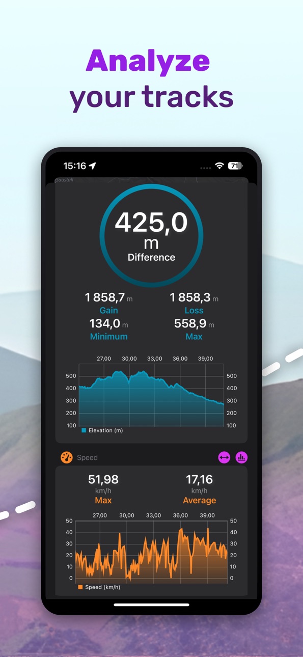
• Measure distance, speed, elevation, climbs, and more
• Dive into detailed charts like elevation and speed profiles
• Compare activities and track your progress over time
• Support for advanced data like heart rate, cadence, and power
NAVIGATE WITH CONFIDENCE
Stay on course wherever you go.
• Real-time GPS tracking with map rotation
• Follow your position live on the map
• See your current speed, pace, elevation and direction
ONLINE & OFFLINE MAPS ANYWHERE
No signal? No problem.
• Access a wide range of maps (Apple Maps, OpenStreetMap, OpenTopoMap, and more)
• Download detailed offline maps worldwide
• Choose from multiple map styles for city or outdoor use
• Enjoy regular map updates with improved data
TRACK, RECORD & SAVE YOUR ADVENTURES
Capture every moment of your journey.
• Record tracks with speed and elevation data
• Save routes and waypoints directly on your device
• Export your data anytime in GPX or KML format
WAYPOINTS MADE SIMPLE
Mark important places and never lose track.
• Add waypoints with a simple tap
• Customize icons and colors
• View detailed waypoint information
PLAN ANYWHERE WITH TRACKBOOK
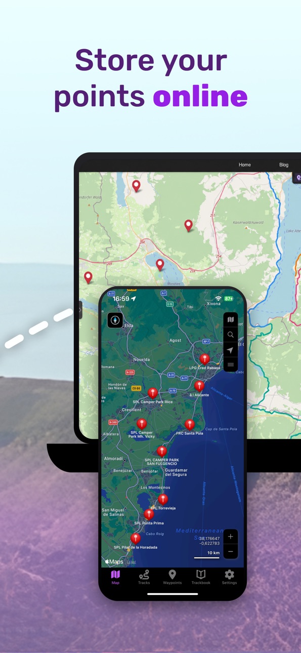
Seamlessly sync with our free planning tool - https://trackbook.com
• Plan routes on desktop
• Sync tracks and waypoints instantly to your device
DESIGNED FOR SIMPLICITY
A clean, intuitive interface that just works.
• Easy to use from the first launch
• Supports both light and dark mode
YOUR ULTIMATE OUTDOOR COMPANION
Whether you're hiking remote trails, cycling long distances, or simply exploring your surroundings, GPX Viewer PRO helps you navigate, analyze, and relive every adventure.
In-App Purchases US pricing
Subscription Subscription
Online services · Monthly$1.99
Capabilities
In-App Purchases
Accessibility
ipadiphonemacrealityDevicetvoswatch
Version history 25 versions
Build 887746429v1.33.22026-07-02 22:14:45
• Fixed track visibility issue on certain offline map styles
• Changed default offline map style to Outdoors
Build 887294617v1.33.12026-06-25 05:41:16
• Fixed problems with track centering
• Fixed crashing when track recording is stopped
• Fixed crashing when selecting track on the map
Build 886584420v1.332026-06-09 12:13:33
• Added option for adding waypoints directly on Trackbook
• Added option for showing/hiding multiple tracks and waypoints
• Added support for opening GPX and KML files form other apps
• Updated Outdoors offline map style
• Chart improvements and enhancements
• Removed kilometers as units for elevation
• Fixed updating offline map data
Build 884764876v1.32.22026-04-21 19:24:42
• Added search on the map
• Updated 3rd party libraries
• Bug fixes
Build 883802006v1.32.12026-04-04 16:02:41
• Improved offline maps performance
• Updated 3rd party libraries
• Fixed map camera track alignment
Build 883273793v1.322026-03-11 23:29:34
• Added profiles for track recording
• Added showing tempo into Follow GPS mode
• Small map marker improvements
• Updated 3rd party libraries
• Bug fixes
Build 882379778v1.31.12026-02-11 21:41:55
• Updated all offline map styles
• Updated 3rd party libraries
• Fixed searching in track and waypoint tabs
• Bug fixes
Build 881938341v1.312026-01-29 19:17:41
• Added measurement tool
• Added option to change track direction
• Added legends for offline map styles
• Enhanced waypoint icons
• Updated 3rd party libraries
• Bug fixes
Build 879655810v1.302025-11-21 08:14:45
• Added showing app changes
• Added support for tapping on POIs on the online map
• Added showing coordinates map screen
• Added MGRS and UTM coordinate types
• Redesigned map screen
• Bug fixes
Build 878164843v1.29.42025-09-22 23:50:48
• Added option to enable/disable clustering of waypoints in online map
• Added option to set coordinates format
• Added support for tapping on POIs on the offline map
• Added support for selecting track by tapping on track line
• Small visual enhancements
Build 877812909v1.29.32025-09-03 23:21:09
• Added option to set color theme for Refill offline map style
• Small UI fixes on iPad devices
Build 877590302v1.29.22025-08-27 06:47:58
• Added new export dialog
• Added option to set track width
• Added option to reset to default settings
• Fixed navbar buttons in Tracks, Waypoints and Trackbook tabs on iPads
• Fixed use default track and waypoint name from import when no name is assigned to track/waypoint
• Fixed not working option to use color from file for tracks
Build 877348867v1.29.12025-08-20 02:39:16
• Added new import dialog
• Bug fixes
Build 877069645v1.292025-08-08 16:40:55
• Added brand new Outdoors offline map style for outdoor activities
• Added information when offline maps updates are available
• Added Select all option into Track and Waypoint lists
• Added showing elevation into waypoint detail screen
• Added automatic selection of metric or imperial units when app is first starts
• Fixed several issues with importing gpx and kml files
Build 876611370v1.28.32025-07-23 00:09:36
• Fixed importing KML files
Build 876202603v1.28.22025-07-08 15:28:23
• Added off-track warning when Follow GPS functionality is enabled
• Updated multiple translations
• Bug fixes
Build 875664289v1.28.12025-06-18 04:46:01
• Small UI improvements
• Stability improvements
• Fixed inability to scroll on track and waypoint detail screens on iPads
Build 874752643v1.282025-06-06 23:37:47
• Automatically set imperial or metric units on first app start
• Chart UI fixes and improvements
• Other UI fixes and improvements
• Fixed crashing when importing settings
• Fixed memory leaks and freezing app when refreshing Trackbook data
Build 874472752v1.27.12025-05-02 15:29:39
• Stability improvements
• Small UI enhancements and improvements
• Fixed UI bugs in waypoint detail screen
Build 873596616v1.272025-04-10 19:04:21
• Added editing of metadata of Trackbook tracks and waypoints (require active Online services subscription)
• Added deleting of Trackbook tracks and waypoints (require active Online services subscription)
• Added option to show/hide waypoint names on the map
• Added showing of current GPS position on the map chart
• Added mapy.cz premium online maps
• Enhanced track and waypoint detail screens
• Changed map chart marker showing x and y values
• Do not turn off screen when map tab is selected
Build 873001851v1.26.152025-03-21 20:44:33
• Updated 3rd party libraries
Build 872638660v1.26.142025-02-20 01:17:24
• Fixed switching between online maps
Build 872567898v1.26.132025-02-18 07:55:27
• Fixed issues with track line width when switching between online maps
• Fixed not working showing/hiding track start and end icons from settings
Build 872342436v1.26.122025-02-09 20:59:58
• Added Apple 3D maps
Build 872081997v1.26.112025-01-31 03:01:47
• Reduced the size of the application
Price history by region
Currency
Show
Columns
Search
Availability 70 of 70 storefronts
| Region | Language | Price | Ratings | Avg | Version |
|---|---|---|---|---|---|
| US | en-US | USD 6.99 | 204 | 4.6 | 1.33.2 |
| MX | es-MX | MXN 149 | 140 | 4.7 | 1.33.2 |
| BR | pt-BR | BRL 49.9 | 103 | 4.4 | 1.33.2 |
| IT | it | EUR 7.99 | 83 | 4.0 | 1.33.2 |
| CH | de-CH | CHF 6 | 43 | 4.1 | 1.33.2 |
| AU | en-AU | AUD 9.99 | 27 | 4.2 | 1.33.2 |
| IN | en-GB | INR 699 | 24 | 4.6 | 1.33.2 |
| ZA | en-GB | ZAR 149.99 | 18 | 3.9 | 1.33.2 |
| PL | en-GB | PLN 29.99 | 13 | 4.1 | 1.33.2 |
| PH | en-GB | PHP 449 | 6 | 4.3 | 1.33.2 |
| CZ | en-GB | CZK 199 | 4 | 2.8 | 1.33.2 |
| LT | en-GB | EUR 7.99 | 4 | 3.0 | 1.33.2 |
| FI | en-GB | EUR 7.99 | 2 | 4.5 | 1.33.2 |
| GH | en-GB | USD 7.99 | 1 | 4.0 | 1.33.2 |
| IS | en-GB | USD 7.99 | 1 | 5.0 | 1.33.2 |
| JP | ja | JPY 1100 | 1 | 5.0 | 1.33.2 |
| TN | en-GB | USD 6.99 | 1 | 5.0 | 1.33.2 |
| AF | en-GB | USD 6.99 | 0 | — | 1.33.2 |
| AI | en-GB | USD 6.99 | 0 | — | 1.33.2 |
| AL | en-GB | USD 7.99 | 0 | — | 1.33.2 |
| AO | en-GB | USD 6.99 | 0 | — | 1.33.2 |
| BB | en-GB | USD 7.99 | 0 | — | 1.33.2 |
| BF | en-GB | USD 6.99 | 0 | — | 1.33.2 |
| BJ | en-GB | USD 7.99 | 0 | — | 1.33.2 |
| BM | en-GB | USD 6.99 | 0 | — | 1.33.2 |
| BS | en-GB | USD 7.99 | 0 | — | 1.33.2 |
| BW | en-GB | USD 6.99 | 0 | — | 1.33.2 |
| CI | fr-FR | USD 7.99 | 0 | — | 1.33.2 |
| CM | fr-FR | USD 7.99 | 0 | — | 1.33.2 |
| CV | en-GB | USD 6.99 | 0 | — | 1.33.2 |
| CY | en-GB | EUR 7.99 | 0 | — | 1.33.2 |
| DM | en-GB | USD 6.99 | 0 | — | 1.33.2 |
| GD | en-GB | USD 6.99 | 0 | — | 1.33.2 |
| GM | en-GB | USD 6.99 | 0 | — | 1.33.2 |
| GW | en-GB | USD 6.99 | 0 | — | 1.33.2 |
| KE | en-GB | USD 7.99 | 0 | — | 1.33.2 |
| KN | en-GB | USD 6.99 | 0 | — | 1.33.2 |
| KW | en-GB | USD 6.99 | 0 | — | 1.33.2 |
| KY | en-GB | USD 6.99 | 0 | — | 1.33.2 |
| LR | en-GB | USD 6.99 | 0 | — | 1.33.2 |
| LY | en-GB | USD 6.99 | 0 | — | 1.33.2 |
| MD | en-GB | USD 7.99 | 0 | — | 1.33.2 |
| MK | en-GB | USD 6.99 | 0 | — | 1.33.2 |
| ML | en-GB | USD 6.99 | 0 | — | 1.33.2 |
| MO | zh-Hant-HK | USD 6.99 | 0 | — | 1.33.2 |
| MS | en-GB | USD 6.99 | 0 | — | 1.33.2 |
| MT | en-GB | EUR 7.99 | 0 | — | 1.33.2 |
| MU | en-GB | USD 7.99 | 0 | — | 1.33.2 |
| MW | en-GB | USD 6.99 | 0 | — | 1.33.2 |
| MZ | en-GB | USD 6.99 | 0 | — | 1.33.2 |
| NA | en-GB | USD 6.99 | 0 | — | 1.33.2 |
| NG | en-GB | NGN 9900 | 0 | — | 1.33.2 |
| NR | en-GB | USD 6.99 | 0 | — | 1.33.2 |
| PG | en-GB | USD 6.99 | 0 | — | 1.33.2 |
| PK | en-GB | PKR 1900 | 0 | — | 1.33.2 |
| RW | en-GB | USD 6.99 | 0 | — | 1.33.2 |
| SB | en-GB | USD 6.99 | 0 | — | 1.33.2 |
| SC | en-GB | USD 6.99 | 0 | — | 1.33.2 |
| SL | en-GB | USD 6.99 | 0 | — | 1.33.2 |
| SN | en-GB | USD 7.99 | 0 | — | 1.33.2 |
| ST | en-GB | USD 6.99 | 0 | — | 1.33.2 |
| SZ | en-GB | USD 6.99 | 0 | — | 1.33.2 |
| TC | en-GB | USD 6.99 | 0 | — | 1.33.2 |
| TT | en-GB | USD 6.99 | 0 | — | 1.33.2 |
| TZ | en-GB | TZS 19900 | 0 | — | 1.33.2 |
| UG | en-GB | USD 7.99 | 0 | — | 1.33.2 |
| VC | en-GB | USD 6.99 | 0 | — | 1.33.2 |
| VG | en-GB | USD 6.99 | 0 | — | 1.33.2 |
| ZM | en-GB | USD 7.99 | 0 | — | 1.33.2 |
| ZW | en-GB | USD 7.99 | 0 | — | 1.33.2 |
Change log 29 changes · US
✎
releaseNotes updated
• Fixed track visibility issue on certain offline map styles
• Changed default offline map style to Outdoors
✎
description updated
EXPLORE DEEPER. NAVIGATE SMARTER. RELIVE EVERY ADVENTURE.
Do you have GPX or KML tracks you love? Or are you ready to head into the mountains and record your ne
✎
subtitle updated
GPS offline maps for GPX/KML
✎
name updated
GPX Viewer PRO: Hike & Bike
◆
Version 1.33.2 released
• Fixed track visibility issue on certain offline map styles
• Changed default offline map style to Outdoors
◆
Version 1.33.1 released
• Fixed problems with track centering
• Fixed crashing when track recording is stopped
• Fixed crashing when selecting track on the map
◆
Version 1.33 released
• Added option for adding waypoints directly on Trackbook
• Added option for showing/hiding multiple tracks and waypoints
• Added support for opening GPX and KML files form other apps
• Updated Outdoors offline map style
• Chart improvement
◆
Version 1.32.2 released
• Added search on the map
• Updated 3rd party libraries
• Bug fixes
◆
Version 1.32.1 released
• Improved offline maps performance
• Updated 3rd party libraries
• Fixed map camera track alignment
◆
Version 1.32 released
• Added profiles for track recording
• Added showing tempo into Follow GPS mode
• Small map marker improvements
• Updated 3rd party libraries
• Bug fixes
◆
Version 1.31.1 released
• Updated all offline map styles
• Updated 3rd party libraries
• Fixed searching in track and waypoint tabs
• Bug fixes
◆
Version 1.31 released
• Added measurement tool
• Added option to change track direction
• Added legends for offline map styles
• Enhanced waypoint icons
• Updated 3rd party libraries
• Bug fixes
◆
Version 1.30 released
• Added showing app changes
• Added support for tapping on POIs on the online map
• Added showing coordinates map screen
• Added MGRS and UTM coordinate types
• Redesigned map screen
• Bug fixes
◆
Version 1.29.4 released
• Added option to enable/disable clustering of waypoints in online map
• Added option to set coordinates format
• Added support for tapping on POIs on the offline map
• Added support for selecting track by tapping on track line
• Small visu
◆
Version 1.29.3 released
• Added option to set color theme for Refill offline map style
• Small UI fixes on iPad devices
◆
Version 1.29.2 released
• Added new export dialog
• Added option to set track width
• Added option to reset to default settings
• Fixed navbar buttons in Tracks, Waypoints and Trackbook tabs on iPads
• Fixed use default track and waypoint name from import when no
◆
Version 1.29.1 released
• Added new import dialog
• Bug fixes
◆
Version 1.29 released
• Added brand new Outdoors offline map style for outdoor activities
• Added information when offline maps updates are available
• Added Select all option into Track and Waypoint lists
• Added showing elevation into waypoint detail screen
•
◆
Version 1.28.3 released
• Fixed importing KML files
◆
Version 1.28.2 released
• Added off-track warning when Follow GPS functionality is enabled
• Updated multiple translations
• Bug fixes
◆
Version 1.28.1 released
• Small UI improvements
• Stability improvements
• Fixed inability to scroll on track and waypoint detail screens on iPads
◆
Version 1.28 released
• Automatically set imperial or metric units on first app start
• Chart UI fixes and improvements
• Other UI fixes and improvements
• Fixed crashing when importing settings
• Fixed memory leaks and freezing app when refreshing Trackbook dat
◆
Version 1.27.1 released
• Stability improvements
• Small UI enhancements and improvements
• Fixed UI bugs in waypoint detail screen
◆
Version 1.27 released
• Added editing of metadata of Trackbook tracks and waypoints (require active Online services subscription)
• Added deleting of Trackbook tracks and waypoints (require active Online services subscription)
• Added option to show/hide waypoin
◆
Version 1.26.15 released
• Updated 3rd party libraries
◆
Version 1.26.14 released
• Fixed switching between online maps
◆
Version 1.26.13 released
• Fixed issues with track line width when switching between online maps
• Fixed not working showing/hiding track start and end icons from settings
◆
Version 1.26.12 released
• Added Apple 3D maps
◆
Version 1.26.11 released
• Reduced the size of the application