Home › Navigation

 US
US
1 of 1 storefronts
Content in en-US
Content in en-US
Information
Preview 2 platforms
iPhone 6 images




iPad 6 images


What’s New Version 1.41
- Support for Geo Ads
Description
Ideal for navigation onboard of your sailing yacht, motorship, canoe or longboat:
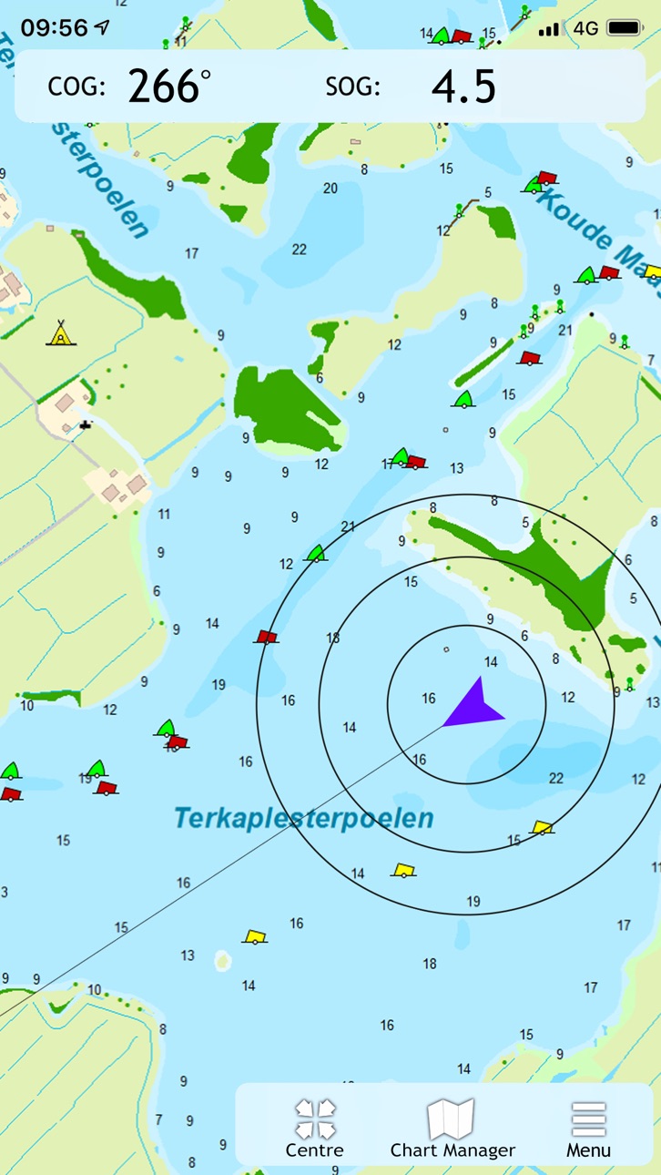
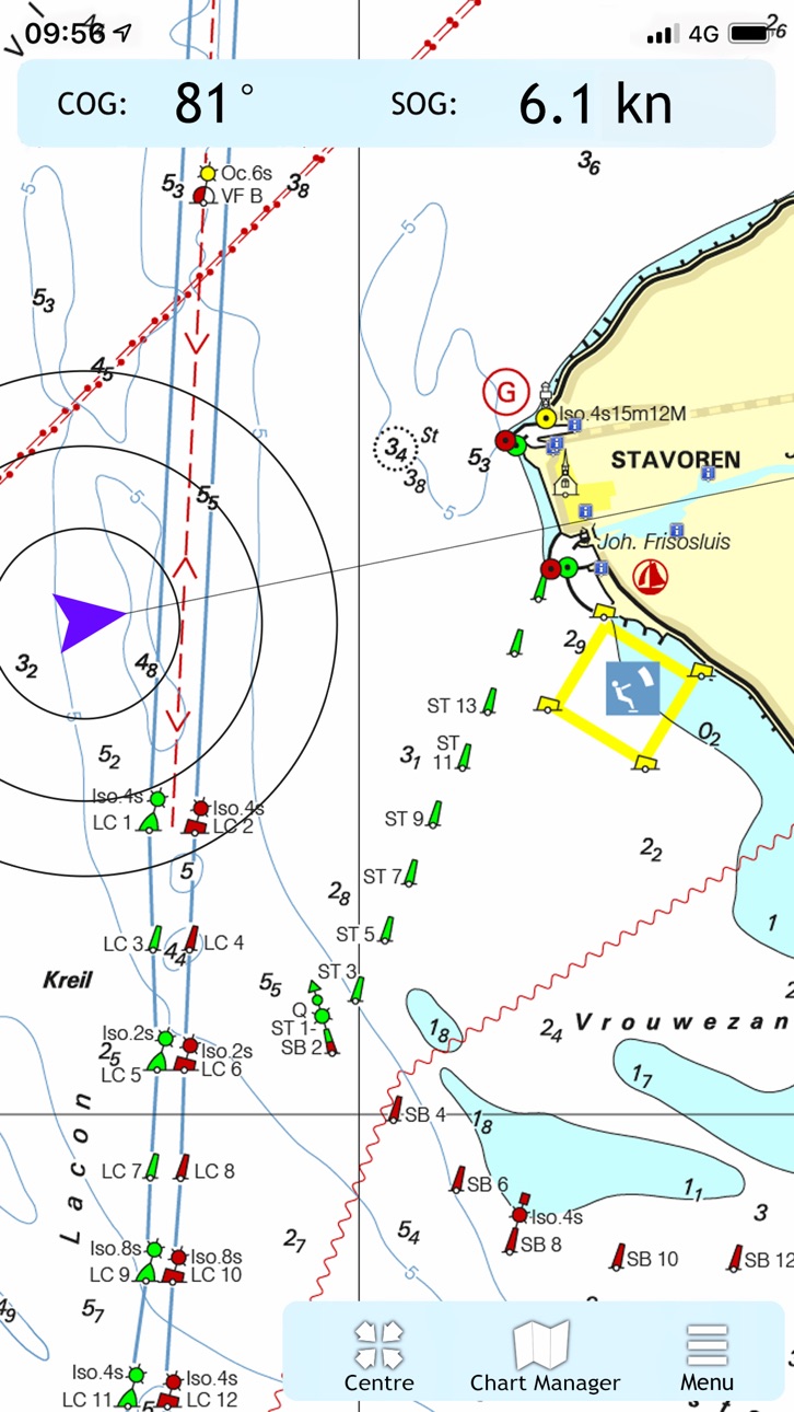
- Always know where you are, how fast you go and what your course is using a GPS receiver (internal or Bluetooth).
- Download the chart of your sailing area and check the current depths, buoys and other nautical information.
- Place a navigation waypoint and sail to your destination using the course line, Course to Go and Distance to Go.
- Waterway network: View the information of the bridges, locks and waterways.
- View your sailed track on the chart.
- Show the distance circles around your GPS position.
At the first start-up of the app, you will be asked to log in with your account. The free default online charts from Apple are available in the app for orientation. The DKW-charts of 2018 and newer, which are connected to your account, can be downloaded directly in this app and be used for navigation.
Accessibility
ipadiphonemacrealityDevicetvoswatch
Version history 25 versions
Build 883846908v1.412026-03-30 12:59:51
- Support for Geo Ads
Build 881640464v1.402026-01-26 14:57:53
- Support for 2026 charts.
Build 874054408v1.372025-04-22 07:42:38
Various updates
Build 871206019v1.362025-01-20 10:16:32
Support for 2025 editions of the water charts.
Build 869042641v1.352024-09-18 07:51:28
Added:
- Extra info for bridges & locks.
Build 862291962v1.342024-05-15 12:53:51
- Improvements in chart display
Build 861280044v1.272023-11-07 13:24:23
- Update to enable waterway network in 2024 edition charts.
Build 859103367v1.262023-08-11 22:09:42
- Waypoints will no longer be duplicated when their respective maps are disabled.
- Fix for usage on Airplay and Apple TV
- Various other enhancements.
Build 858957441v1.252023-08-08 09:35:31
- Waypoints will no longer be duplicated when their respective maps are disabled.
- Fix for usage on Airplay and Apple TV
- Various other enhancements.
Build 856048688v1.212023-04-04 10:15:53
- Problem solved about showing bridges and some other objects.
Build 855095617v1.202023-02-23 17:40:31
- Improvement that results in fewer crashes.
- Various other improvements and bugfixes.
Build 854567018v1.192023-01-24 15:31:25
- Waterway Network enabled for 2023 charts.
- New feature: Transparancy enabled for chart that support it.
- Various fixes.
Build 851688698v1.182022-08-22 07:06:47
-Follow-chart better fixated during and after scrolling or zooming
Build 851598684v1.172022-08-18 12:12:31
- Improvements with data for bridges and locks in all charts
- Improvements in display of other waypoints
- Various other updates
Build 850410349v1.162022-07-04 10:09:59
- Navigation following the waterways of the route network.
- Various updates in stability.
Build 848806155v1.152022-05-09 11:54:24
- Network active for 2022 charts.
- Solutions for some crashes.
Build 844247931v1.142021-09-23 14:10:38
- Fix for rotation of the user location marker
Build 844036396v1.132021-09-10 11:57:42
- Improvements in stabillity
Build 843546707v1.122021-08-26 07:56:41
- Solution for some Gps problems.
- Improvements in stabillity.
- Improvements in startup speed.
Build 843338457v1.112021-07-29 23:38:48
- Display of the waterway-network, and extra info on each specific location.
- Solution for some Gps problems.
- Improvements in stabillity
Build 843129227v1.102021-07-21 12:03:02
- Display of the waterway-network, and extra info on each specific location.
- Solution for some Gps problems.
Build 839792183v1.92020-12-29 20:31:39
- Improvements in stability.
Build 836630310v1.8.42020-06-30 02:06:14
- Small changes in the background when Apple Maps is disabled.
Build 836525307v1.8.22020-06-23 11:27:17
- A bug was fixed where charts would not be sharp at certain zoom levels.
Build 833048616v1.82020-01-09 11:45:44
Several stability improvements.
No pricing data captured yet — comparisons appear once the app has paid storefronts or in-app purchases.
Availability 1 of 1 storefronts
| Region | Language | Price | Ratings | Avg | Version |
|---|---|---|---|---|---|
| US | en-US | Free | 3 | 1.3 | 1.41 |
Change log 28 changes · US
✎
releaseNotes updated
- Support for Geo Ads
✎
description updated
Ideal for navigation onboard of your sailing yacht, motorship, canoe or longboat:
- Always know where you are, how fast you go and what your course is using a
✎
name updated
WinGPS Marine
◆
Version 1.41 released
- Support for Geo Ads
◆
Version 1.40 released
- Support for 2026 charts.
◆
Version 1.37 released
Various updates
◆
Version 1.36 released
Support for 2025 editions of the water charts.
◆
Version 1.35 released
Added:
- Extra info for bridges & locks.
◆
Version 1.34 released
- Improvements in chart display
◆
Version 1.27 released
- Update to enable waterway network in 2024 edition charts.
◆
Version 1.26 released
- Waypoints will no longer be duplicated when their respective maps are disabled.
- Fix for usage on Airplay and Apple TV
- Various other enhancements.
◆
Version 1.25 released
- Waypoints will no longer be duplicated when their respective maps are disabled.
- Fix for usage on Airplay and Apple TV
- Various other enhancements.
◆
Version 1.21 released
- Problem solved about showing bridges and some other objects.
◆
Version 1.20 released
- Improvement that results in fewer crashes.
- Various other improvements and bugfixes.
◆
Version 1.19 released
- Waterway Network enabled for 2023 charts.
- New feature: Transparancy enabled for chart that support it.
- Various fixes.
◆
Version 1.18 released
-Follow-chart better fixated during and after scrolling or zooming
◆
Version 1.17 released
- Improvements with data for bridges and locks in all charts
- Improvements in display of other waypoints
- Various other updates
◆
Version 1.16 released
- Navigation following the waterways of the route network.
- Various updates in stability.
◆
Version 1.15 released
- Network active for 2022 charts.
- Solutions for some crashes.
◆
Version 1.14 released
- Fix for rotation of the user location marker
◆
Version 1.13 released
- Improvements in stabillity
◆
Version 1.12 released
- Solution for some Gps problems.
- Improvements in stabillity.
- Improvements in startup speed.
◆
Version 1.11 released
- Display of the waterway-network, and extra info on each specific location.
- Solution for some Gps problems.
- Improvements in stabillity
◆
Version 1.10 released
- Display of the waterway-network, and extra info on each specific location.
- Solution for some Gps problems.
◆
Version 1.9 released
- Improvements in stability.
◆
Version 1.8.4 released
- Small changes in the background when Apple Maps is disabled.
◆
Version 1.8.2 released
- A bug was fixed where charts would not be sharp at certain zoom levels.
◆
Version 1.8 released
Several stability improvements.