Home › Sports

Fishing Points: Map & Forecast
Find Best Tides Times to Fish
 US
US
USen-US BRpt-BR
 MXes-MX
 HRen-GB
 PLen-GB
 MVen-GB
 UAen-GB
 ARes-MX
 ZAen-GB
 EGen-GB
 MAen-GB
 JPja
JPja TWzh-Hant-TW
 LBen-GB
 LTen-GB
 CNzh-Hans-CN
 MUen-GB
 BZen-GB
 TTen-GB
 AOen-GB
 FIen-GB
 BSen-GB
 HKzh-Hant-HK
 CIfr-FR
 KRko
KRko CVen-GB
 PWen-GB
 MLen-GB
 GHen-GB
 ISen-GB
 MZen-GB
 BNen-GB
 KEen-GB
 PGen-GB
 GEen-GB
 JOen-GB
 NAen-GB
 AGen-GB
 UZen-GB
 BFen-GB
 KGen-GB
 MGen-GB
 TCen-GB
 AZen-GB
 CMfr-FR
 NGen-GB
 YEen-GB
 IQen-GB
 TZen-GB
 BWen-GB
 TMen-GB
 VGen-GB
 ZWen-GB
 BBen-GB
 DMen-GB
 LAen-GB
 SBen-GB
 SRen-GB
 TJen-GB
 BJen-GB
 BTen-GB
 GYen-GB
 NEen-GB
 NRen-GB
 UGen-GB
 ZMen-GB
66 of 66 storefronts
Content in en-US
Content in en-US
Information
Preview 2 platforms


iPhone 9 images


iPad 10 images





What’s New Version 4.2.2
- iOS15 app launch issues resolved
- Live activities for navigation, recording and anchor mode
- Liquid Glass Design: Enjoy our biggest redesign ever: polished, intuitive, and easier to use
- Resolved Login with Facebook issues
- More lake depth coverage include Connecticut, Michigan, Oklahoma, Ohio, Massachusetts, Iowa, Illinois and Great Lakes
- New account screen to help you manage your account
- Lake depths and contours of selected lakes in Florida, Minnesota, North Dakota, Nebraska, New Hampshire, Washington
- Search your saved location list by name or notes
- Improved location list sorting and grouping
- River station list
- Map layers
- Improved distance measuring tool
- Easier kmz & gpx files import
- Rain radar in Weather
- Water levels & flows for 35k+ river stations
- Radar improvements
- Weather alerts improvements
- Added new POIs
- Now you can save POIs or share as locations
- Boat ramps available in the US and worldwide
- Sync improvements between all your devices
- Severe weather alerts
- Sync data across all your devices including web app
- Better species search
- Have more control over your saved fishing locations with more than 40 new icons and 10 colours
- Import coordinates from text or if you dont know which coordinate format
- Show or hide location markers on the map
- Hourly weather expanded to wind gusts and precipitation intensity
Description
Download all-in-one fishing app already connecting more than 12 million anglers worldwide. Fishing Points is fishing forecasts and maps app, made for beginner-, seasoned-, and pro anglers to discover new fishing spots, understand best fishing times and catch more fish. Suitable for both salt and freshwater anglers on open seas, lakes or rivers.
Explore our detailed fishing forecasts to discover the best fishing times for your location. Understand how fish brain works by analyzing fishing tides, moon phases, marine forecasts, solunar and weather forecasts. We show current conditions and forecasts for temperature, rain probability, rain intensity, wind speed, gusts, wind directions and air pressure all in one app.
To know where to fish, explore four different fishing map types, save and discover fishing spots, favorite locations, trotlines, and trolling paths. Access detailed satellite fishing maps, worldwide nautical charts, or use offline mode with marine nautical maps for boating (NOAA). View seagrass, oyster beds, mangrove layers, and now detailed lake maps with depth and contour charts - perfect for spotting drop-offs, channels, and structure (available in select states: Florida, Minnesota, Nebraska, New Hampshire, North Dakota, and Washington). Revisit your trips with a private catch logbook, check bag limits and fishing rules, and learn what works to maximize your next trip!
FEEDING TIMES FORECAST
- Hourly feeding times with strong major and minor time intervals
- Daily fish activity
- Best fishing times calendar for bass and other popular species
- Customizable smart notifications on days with feeding times
FIND YOUR LOCATIONS
- Save fishing spots, locations, hotspots and waypoints
- Record trolling paths and trotlines
- Save your favorite locations with more than 40 icons and 10 colors
- Find saved locations with GPS
- The only fishing app with worldwide access to nautical maps
- Offline mode with nautical charts provided by NOAA
- Get information and quickly locate more than 50.000 boat ramps worldwide
- Seagrass, oyster beds, mangroves map layers
- Compass
- Measure distances
FISHING WEATHER
- Accurate current fishing weather conditions with hourly forecast for humidity, precipitation probability, UV index
- Wind forecast including wind speed, gusts and direction
- Current fishing barometer with hourly air pressure forecast
- Severe live weather alerts
- Rain radar
RIVER DATA
- Current water levels & flows for 35k+ river stations
TIDES FOR FISHING
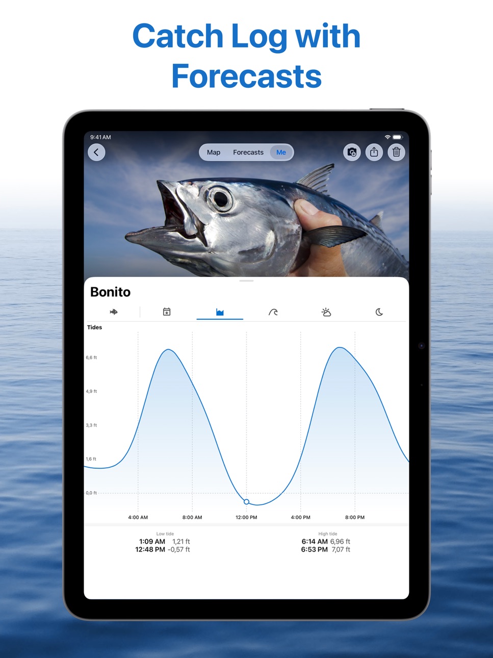
- Hourly tides for fishing charts with information on the next high and low tides
- Tide prediction charts with detailed tidal current
- Tides overview forecasts with daily highest and lowest tides
MARINE FORECAST
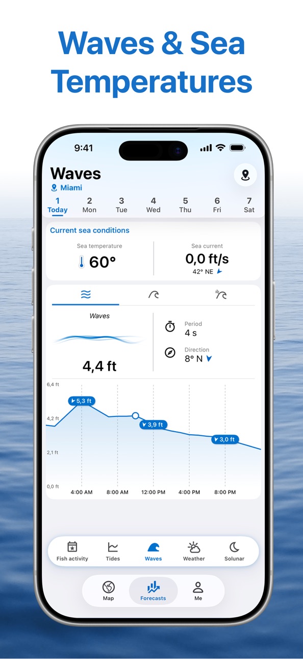
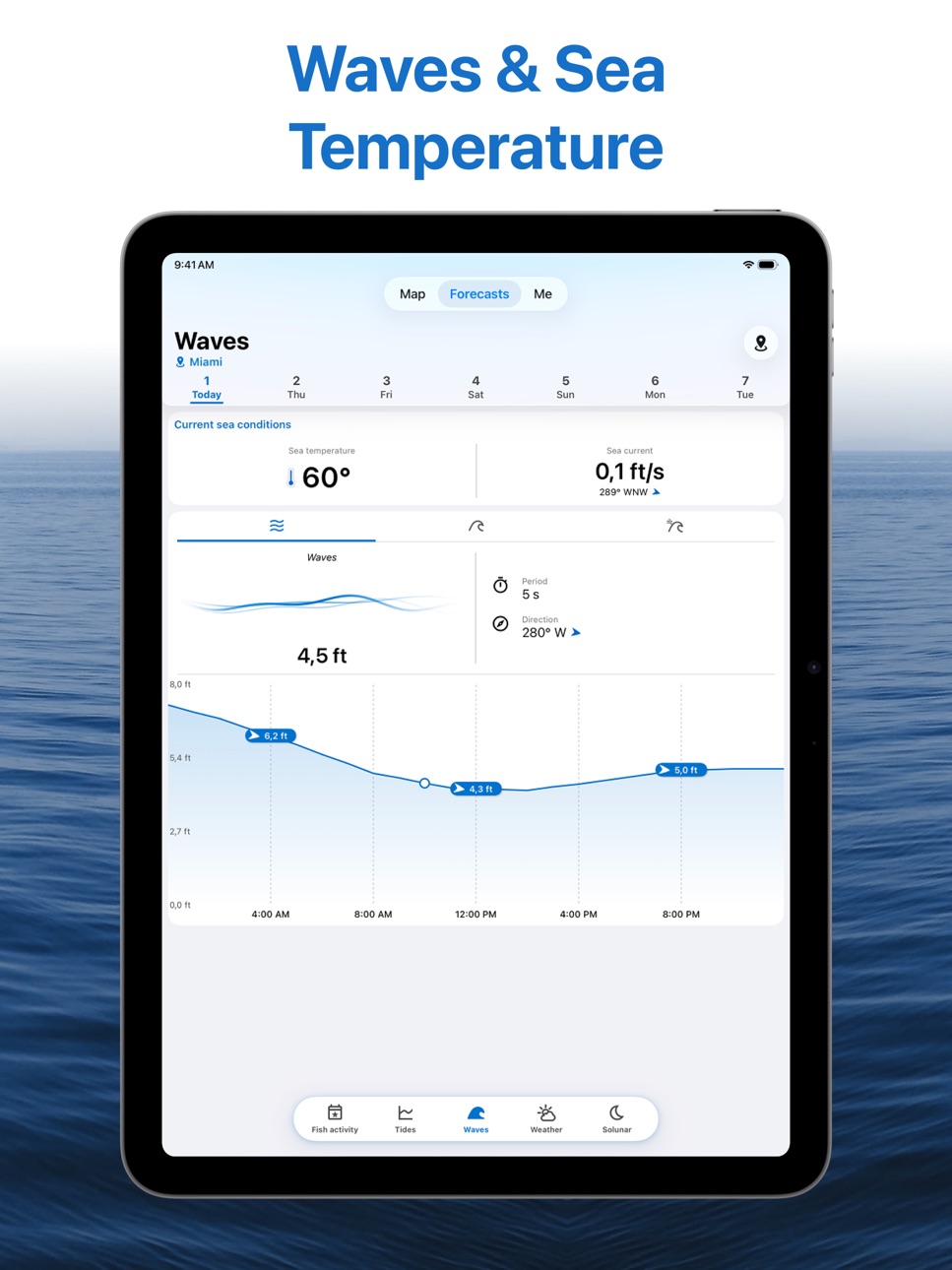
- Hourly waves forecast (waves, swell, wind waves)
- Sea temperature (SST)
- Sea and ocean currents data
SOLUNAR DATA
- Sunrise and sunset times
- Sun positions
- Moonrise and moonset times
- Moon positions
- Moon phases
SYNC DATA
- Access your saved data across all your computer and mobile devices.
- Use Webapp to plan and analyze fishing trips on your computer. Try Webapp on https://web.fishingpoints.app
FISH RULES AND FISH SPECIES
- Information on fish species including bass, trout, snapper, snook, drum, grouper, catfish etc.
- Fish rules and regulations on bag limits and open seasons for selected US States (Florida, Texas, Georgia, North Carolina and Louisiana)
CATCH LOG
- Create a fishing log and save the details of every catch (photos, weight, length)
- Weather, solunar and tide information are added automatically to your catches
SHARE
- Import kmz or gpx files from GPS devices or other apps
- Share your locations with friends
- Share catch photos with your fellow anglers
In case of questions, comments or suggestions, please send us a note to support@fishingpoints.app. Happy fishing!
Privacy policy: https://fishingpoints.app/privacy
Terms of Use: https://fishingpoints.app/terms
In-App Purchases US pricing
Premium Subscription
Monthly$9.99
Basic Premium · Yearly$29.99
Advanced Premium · Yearly$49.99
Capabilities
In-App Purchases
Accessibility
ipadiphonemacrealityDevicetvoswatch
Version history 25 versions
Build 887183678v4.2.22026-06-19 21:57:32
- iOS15 app launch issues resolved
- Live activities for navigation, recording and anchor mode
- Liquid Glass Design: Enjoy our biggest redesign ever: polished, intuitive, and easier to use
- Resolved Login with Facebook issues
- More lake depth coverage include Connecticut, Michigan, Oklahoma, Ohio, Massachusetts, Iowa, Illinois and Great Lakes
- New account screen to help you manage your account
- Lake depths and contours of selected lakes in Florida, Minnesota, North Dakota, Nebraska, New Hampshire, Washington
- Search your saved location list by name or notes
- Improved location list sorting and grouping
- River station list
- Map layers
- Improved distance measuring tool
- Easier kmz & gpx files import
- Rain radar in Weather
- Water levels & flows for 35k+ river stations
- Radar improvements
- Weather alerts improvements
- Added new POIs
- Now you can save POIs or share as locations
- Boat ramps available in the US and worldwide
- Sync improvements between all your devices
- Severe weather alerts
- Sync data across all your devices including web app
- Better species search
- Have more control over your saved fishing locations with more than 40 new icons and 10 colours
- Import coordinates from text or if you dont know which coordinate format
- Show or hide location markers on the map
- Hourly weather expanded to wind gusts and precipitation intensity
Build 886589648v4.2.12026-06-06 03:05:53
- iOS15 app launch issues resolved
- Live activities for navigation, recording and anchor mode
- Liquid Glass Design: Enjoy our biggest redesign ever: polished, intuitive, and easier to use
- Resolved Login with Facebook issues
- More lake depth coverage include Connecticut, Michigan, Oklahoma, Ohio, Massachusetts, Iowa, Illinois and Great Lakes
- New account screen to help you manage your account
- Lake depths and contours of selected lakes in Florida, Minnesota, North Dakota, Nebraska, New Hampshire, Washington
- Search your saved location list by name or notes
- Improved location list sorting and grouping
- River station list
- Map layers
- Improved distance measuring tool
- Easier kmz & gpx files import
- Rain radar in Weather
- Water levels & flows for 35k+ river stations
- Radar improvements
- Weather alerts improvements
- Added new POIs
- Now you can save POIs or share as locations
- Boat ramps available in the US and worldwide
- Sync improvements between all your devices
- Severe weather alerts
- Sync data across all your devices including web app
- Better species search
- Have more control over your saved fishing locations with more than 40 new icons and 10 colours
- Import coordinates from text or if you dont know which coordinate format
- Show or hide location markers on the map
- Hourly weather expanded to wind gusts and precipitation intensity
Build 885805627v4.2.02026-05-23 02:20:08
- iOS15 app launch issues resolved
- Live activities for navigation, recording and anchor mode
- Liquid Glass Design: Enjoy our biggest redesign ever: polished, intuitive, and easier to use
- Resolved Login with Facebook issues
- More lake depth coverage include Connecticut, Michigan, Oklahoma, Ohio, Massachusetts, Iowa, Illinois and Great Lakes
- New account screen to help you manage your account
- Lake depths and contours of selected lakes in Florida, Minnesota, North Dakota, Nebraska, New Hampshire, Washington
- Search your saved location list by name or notes
- Improved location list sorting and grouping
- River station list
- Map layers
- Improved distance measuring tool
- Easier kmz & gpx files import
- Rain radar in Weather
- Water levels & flows for 35k+ river stations
- Radar improvements
- Weather alerts improvements
- Added new POIs
- Now you can save POIs or share as locations
- Boat ramps available in the US and worldwide
- Sync improvements between all your devices
- Severe weather alerts
- Sync data across all your devices including web app
- Better species search
- Have more control over your saved fishing locations with more than 40 new icons and 10 colours
- Import coordinates from text or if you dont know which coordinate format
- Show or hide location markers on the map
- Hourly weather expanded to wind gusts and precipitation intensity
Build 885445100v4.1.42026-05-10 05:30:42
- iOS15 app launch issues resolved
- Live activities for navigation, recording and anchor mode
- Liquid Glass Design: Enjoy our biggest redesign ever: polished, intuitive, and easier to use
- Resolved Login with Facebook issues
- More lake depth coverage include Connecticut, Michigan, Oklahoma, Ohio, Massachusetts, Iowa, Illinois and Great Lakes
- New account screen to help you manage your account
- Lake depths and contours of selected lakes in Florida, Minnesota, North Dakota, Nebraska, New Hampshire, Washington
- Search your saved location list by name or notes
- Improved location list sorting and grouping
- River station list
- Map layers
- Improved distance measuring tool
- Easier kmz & gpx files import
- Rain radar in Weather
- Water levels & flows for 35k+ river stations
- Radar improvements
- Weather alerts improvements
- Added new POIs
- Now you can save POIs or share as locations
- Boat ramps available in the US and worldwide
- Sync improvements between all your devices
- Severe weather alerts
- Sync data across all your devices including web app
- Better species search
- Have more control over your saved fishing locations with more than 40 new icons and 10 colours
- Import coordinates from text or if you dont know which coordinate format
- Show or hide location markers on the map
- Hourly weather expanded to wind gusts and precipitation intensity
Build 885242177v4.1.32026-05-04 17:06:16
- Live activities for navigation, recording and anchor mode
- Liquid Glass Design: Enjoy our biggest redesign ever: polished, intuitive, and easier to use
- Resolved Login with Facebook issues
- More lake depth coverage include Connecticut, Michigan, Oklahoma, Ohio, Massachusetts, Iowa, Illinois and Great Lakes
- New account screen to help you manage your account
- Lake depths and contours of selected lakes in Florida, Minnesota, North Dakota, Nebraska, New Hampshire, Washington
- Search your saved location list by name or notes
- Improved location list sorting and grouping
- River station list
- Map layers
- Improved distance measuring tool
- Easier kmz & gpx files import
- Rain radar in Weather
- Water levels & flows for 35k+ river stations
- Radar improvements
- Weather alerts improvements
- Added new POIs
- Now you can save POIs or share as locations
- Boat ramps available in the US and worldwide
- Sync improvements between all your devices
- Severe weather alerts
- Sync data across all your devices including web app
- Better species search
- Have more control over your saved fishing locations with more than 40 new icons and 10 colours
- Import coordinates from text or if you dont know which coordinate format
- Show or hide location markers on the map
- Hourly weather expanded to wind gusts and precipitation intensity
Build 885172860v4.1.22026-05-02 17:15:58
- Live activities for navigation, recording and anchor mode
- Liquid Glass Design: Enjoy our biggest redesign ever: polished, intuitive, and easier to use
- Resolved Login with Facebook issues
- More lake depth coverage include Connecticut, Michigan, Oklahoma, Ohio, Massachusetts, Iowa, Illinois and Great Lakes
- New account screen to help you manage your account
- Lake depths and contours of selected lakes in Florida, Minnesota, North Dakota, Nebraska, New Hampshire, Washington
- Search your saved location list by name or notes
- Improved location list sorting and grouping
- River station list
- Map layers
- Improved distance measuring tool
- Easier kmz & gpx files import
- Rain radar in Weather
- Water levels & flows for 35k+ river stations
- Radar improvements
- Weather alerts improvements
- Added new POIs
- Now you can save POIs or share as locations
- Boat ramps available in the US and worldwide
- Sync improvements between all your devices
- Severe weather alerts
- Sync data across all your devices including web app
- Better species search
- Have more control over your saved fishing locations with more than 40 new icons and 10 colours
- Import coordinates from text or if you dont know which coordinate format
- Show or hide location markers on the map
- Hourly weather expanded to wind gusts and precipitation intensity
Build 884268946v4.1.12026-04-19 19:18:32
- Liquid Glass Design: Enjoy our biggest redesign ever: polished, intuitive, and easier to use
- Resolved Login with Facebook issues
- More lake depth coverage include Connecticut, Michigan, Oklahoma, Ohio, Massachusetts, Iowa, Illinois and Great Lakes
- New account screen to help you manage your account
- Lake depths and contours of selected lakes in Florida, Minnesota, North Dakota, Nebraska, New Hampshire, Washington
- Search your saved location list by name or notes
- Improved location list sorting and grouping
- River station list
- Map layers
- Improved distance measuring tool
- Easier kmz & gpx files import
- Rain radar in Weather
- Water levels & flows for 35k+ river stations
- Radar improvements
- Weather alerts improvements
- Added new POIs
- Now you can save POIs or share as locations
- Boat ramps available in the US and worldwide
- Sync improvements between all your devices
- Severe weather alerts
- Sync data across all your devices including web app
- Better species search
- Have more control over your saved fishing locations with more than 40 new icons and 10 colours
- Import coordinates from text or if you dont know which coordinate format
- Show or hide location markers on the map
- Hourly weather expanded to wind gusts and precipitation intensity
Build 883750080v4.1.02026-03-27 23:30:04
- Liquid Glass Design: Enjoy our biggest redesign ever: polished, intuitive, and easier to use
- Resolved Login with Facebook issues
- More lake depth coverage include Connecticut, Michigan, Oklahoma, Ohio, Massachusetts, Iowa, Illinois and Great Lakes
- New account screen to help you manage your account
- Lake depths and contours of selected lakes in Florida, Minnesota, North Dakota, Nebraska, New Hampshire, Washington
- Search your saved location list by name or notes
- Improved location list sorting and grouping
- River station list
- Map layers
- Improved distance measuring tool
- Easier kmz & gpx files import
- Rain radar in Weather
- Water levels & flows for 35k+ river stations
- Radar improvements
- Weather alerts improvements
- Added new POIs
- Now you can save POIs or share as locations
- Boat ramps available in the US and worldwide
- Sync improvements between all your devices
- Severe weather alerts
- Sync data across all your devices including web app
- Better species search
- Have more control over your saved fishing locations with more than 40 new icons and 10 colours
- Import coordinates from text or if you dont know which coordinate format
- Show or hide location markers on the map
- Hourly weather expanded to wind gusts and precipitation intensity
Build 883227388v4.0.12026-03-11 18:00:54
- Liquid Glass Design: Enjoy our biggest redesign ever: polished, intuitive, and easier to use
- Resolved Login with Facebook issues
- More lake depth coverage include Connecticut, Michigan, Oklahoma, Ohio, Massachusetts, Iowa, Illinois and Great Lakes
- New account screen to help you manage your account
- Lake depths and contours of selected lakes in Florida, Minnesota, North Dakota, Nebraska, New Hampshire, Washington
- Search your saved location list by name or notes
- Improved location list sorting and grouping
- River station list
- Map layers
- Improved distance measuring tool
- Easier kmz & gpx files import
- Rain radar in Weather
- Water levels & flows for 35k+ river stations
- Radar improvements
- Weather alerts improvements
- Added new POIs
- Now you can save POIs or share as locations
- Boat ramps available in the US and worldwide
- Sync improvements between all your devices
- Severe weather alerts
- Sync data across all your devices including web app
- Better species search
- Have more control over your saved fishing locations with more than 40 new icons and 10 colours
- Import coordinates from text or if you dont know which coordinate format
- Show or hide location markers on the map
- Hourly weather expanded to wind gusts and precipitation intensity
Build 882416092v4.0.02026-02-17 01:17:37
- Liquid Glass Design: Enjoy our biggest redesign ever: polished, intuitive, and easier to use
- Resolved Login with Facebook issues
- More lake depth coverage include Connecticut, Michigan, Oklahoma, Ohio, Massachusetts, Iowa, Illinois and Great Lakes
- New account screen to help you manage your account
- Lake depths and contours of selected lakes in Florida, Minnesota, North Dakota, Nebraska, New Hampshire, Washington
- Search your saved location list by name or notes
- Improved location list sorting and grouping
- River station list
- Map layers
- Improved distance measuring tool
- Easier kmz & gpx files import
- Rain radar in Weather
- Water levels & flows for 35k+ river stations
- Radar improvements
- Weather alerts improvements
- Added new POIs
- Now you can save POIs or share as locations
- Boat ramps available in the US and worldwide
- Sync improvements between all your devices
- Severe weather alerts
- Sync data across all your devices including web app
- Better species search
- Have more control over your saved fishing locations with more than 40 new icons and 10 colours
- Import coordinates from text or if you dont know which coordinate format
- Show or hide location markers on the map
- Hourly weather expanded to wind gusts and precipitation intensity
Build 881861194v3.2.12026-01-27 00:07:59
- Resolved Login with Facebook issues
- More lake depth coverage include Connecticut, Michigan, Oklahoma, Ohio, Massachusetts, Iowa, Illinois and Great Lakes
- New account screen to help you manage your account
- Lake depths and contours of selected lakes in Florida, Minnesota, North Dakota, Nebraska, New Hampshire, Washington
- Search your saved location list by name or notes
- Improved location list sorting and grouping
- River station list
- Map layers
- Improved distance measuring tool
- Easier kmz & gpx files import
- Rain radar in Weather
- Water levels & flows for 35k+ river stations
- Radar improvements
- Weather alerts improvements
- Added new POIs
- Now you can save POIs or share as locations
- Boat ramps available in the US and worldwide
- Sync improvements between all your devices
- Severe weather alerts
- Sync data across all your devices including web app
- Better species search
- Have more control over your saved fishing locations with more than 40 new icons and 10 colours
- Import coordinates from text or if you dont know which coordinate format
- Show or hide location markers on the map
- Hourly weather expanded to wind gusts and precipitation intensity
Build 881786538v3.2.02026-01-25 18:04:40
- Resolved Login with Facebook issues
- More lake depth coverage include Connecticut, Michigan, Oklahoma, Ohio, Massachusetts, Iowa, Illinois and Great Lakes
- New account screen to help you manage your account
- Lake depths and contours of selected lakes in Florida, Minnesota, North Dakota, Nebraska, New Hampshire, Washington
- Search your saved location list by name or notes
- Improved location list sorting and grouping
- River station list
- Map layers
- Improved distance measuring tool
- Easier kmz & gpx files import
- Rain radar in Weather
- Water levels & flows for 35k+ river stations
- Radar improvements
- Weather alerts improvements
- Added new POIs
- Now you can save POIs or share as locations
- Boat ramps available in the US and worldwide
- Sync improvements between all your devices
- Severe weather alerts
- Sync data across all your devices including web app
- Better species search
- Have more control over your saved fishing locations with more than 40 new icons and 10 colours
- Import coordinates from text or if you dont know which coordinate format
- Show or hide location markers on the map
- Hourly weather expanded to wind gusts and precipitation intensity
Build 880379175v3.1.22025-12-09 03:48:54
- Resolved Login with Facebook issues
- More lake depth coverage include Connecticut, Michigan, Oklahoma, Ohio, Massachusetts, Iowa, Illinois and Great Lakes
- New account screen to help you manage your account
- Lake depths and contours of selected lakes in Florida, Minnesota, North Dakota, Nebraska, New Hampshire, Washington
- Search your saved location list by name or notes
- Improved location list sorting and grouping
- River station list
- Map layers
- Improved distance measuring tool
- Easier kmz & gpx files import
- Rain radar in Weather
- Water levels & flows for 35k+ river stations
- Radar improvements
- Weather alerts improvements
- Added new POIs
- Now you can save POIs or share as locations
- Boat ramps available in the US and worldwide
- Sync improvements between all your devices
- Severe weather alerts
- Sync data across all your devices including web app
- Better species search
- Have more control over your saved fishing locations with more than 40 new icons and 10 colours
- Import coordinates from text or if you dont know which coordinate format
- Show or hide location markers on the map
- Hourly weather expanded to wind gusts and precipitation intensity
Build 879679154v3.1.12025-11-12 23:26:26
- More lake depth coverage include Connecticut, Michigan, Oklahoma, Ohio, Massachusetts, Iowa, Illinois and Great Lakes
- New account screen to help you manage your account
- Lake depths and contours of selected lakes in Florida, Minnesota, North Dakota, Nebraska, New Hampshire, Washington
- Search your saved location list by name or notes
- Improved location list sorting and grouping
- River station list
- Map layers
- Improved distance measuring tool
- Easier kmz & gpx files import
- Rain radar in Weather
- Water levels & flows for 35k+ river stations
- Radar improvements
- Weather alerts improvements
- Added new POIs
- Now you can save POIs or share as locations
- Boat ramps available in the US and worldwide
- Sync improvements between all your devices
- Severe weather alerts
- Sync data across all your devices including web app
- Better species search
- Have more control over your saved fishing locations with more than 40 new icons and 10 colours
- Import coordinates from text or if you dont know which coordinate format
- Show or hide location markers on the map
- Hourly weather expanded to wind gusts and precipitation intensity
Build 879150631v3.1.02025-10-23 15:04:36
- More lake depth coverage include Connecticut, Michigan, Oklahoma, Ohio, Massachusetts, Iowa, Illinois and Great Lakes
- New account screen to help you manage your account
- Lake depths and contours of selected lakes in Florida, Minnesota, North Dakota, Nebraska, New Hampshire, Washington
- Search your saved location list by name or notes
- Improved location list sorting and grouping
- River station list
- Map layers
- Improved distance measuring tool
- Easier kmz & gpx files import
- Rain radar in Weather
- Water levels & flows for 35k+ river stations
- Radar improvements
- Weather alerts improvements
- Added new POIs
- Now you can save POIs or share as locations
- Boat ramps available in the US and worldwide
- Sync improvements between all your devices
- Severe weather alerts
- Sync data across all your devices including web app
- Better species search
- Have more control over your saved fishing locations with more than 40 new icons and 10 colours
- Import coordinates from text or if you dont know which coordinate format
- Show or hide location markers on the map
- Hourly weather expanded to wind gusts and precipitation intensity
Build 877552161v3.0.22025-08-26 01:39:59
- Lake depths and contours of selected lakes in Florida, Minnesota, North Dakota, Nebraska, New Hampshire, Washington
- Search your saved location list by name or notes
- Improved location list sorting and grouping
- River station list
- Map layers
- Improved distance measuring tool
- Easier kmz & gpx files import
- Rain radar in Weather
- Water levels & flows for 35k+ river stations
- Radar improvements
- Weather alerts improvements
- Added new POIs
- Now you can save POIs or share as locations
- Boat ramps available in the US and worldwide
- Sync improvements between all your devices
- Severe weather alerts
- Sync data across all your devices including web app
- Better species search
- Have more control over your saved fishing locations with more than 40 new icons and 10 colours
- Import coordinates from text or if you dont know which coordinate format
- Show or hide location markers on the map
- Hourly weather expanded to wind gusts and precipitation intensity
Build 877038333v3.0.12025-08-11 23:50:04
- Lake depths and contours of selected lakes in Florida, Minnesota, North Dakota, Nebraska, New Hampshire, Washington
- Search your saved location list by name or notes
- Improved location list sorting and grouping
- River station list
- Map layers
- Improved distance measuring tool
- Easier kmz & gpx files import
- Rain radar in Weather
- Water levels & flows for 35k+ river stations
- Radar improvements
- Weather alerts improvements
- Added new POIs
- Now you can save POIs or share as locations
- Boat ramps available in the US and worldwide
- Sync improvements between all your devices
- Severe weather alerts
- Sync data across all your devices including web app
- Better species search
- Have more control over your saved fishing locations with more than 40 new icons and 10 colours
- Import coordinates from text or if you dont know which coordinate format
- Show or hide location markers on the map
- Hourly weather expanded to wind gusts and precipitation intensity
Build 876654056v3.0.02025-07-24 15:05:44
- Lake depths and contours of selected lakes in Florida, Minnesota, North Dakota, Nebraska, New Hampshire, Washington
- Search your saved location list by name or notes
- Improved location list sorting and grouping
- River station list
- Map layers
- Improved distance measuring tool
- Easier kmz & gpx files import
- Rain radar in Weather
- Water levels & flows for 35k+ river stations
- Radar improvements
- Weather alerts improvements
- Added new POIs
- Now you can save POIs or share as locations
- Boat ramps available in the US and worldwide
- Sync improvements between all your devices
- Severe weather alerts
- Sync data across all your devices including web app
- Better species search
- Have more control over your saved fishing locations with more than 40 new icons and 10 colours
- Import coordinates from text or if you dont know which coordinate format
- Show or hide location markers on the map
- Hourly weather expanded to wind gusts and precipitation intensity
Build 875816558v2.9.92025-06-24 02:14:59
- Search your saved location list by name or notes
- Improved location list sorting and grouping
- River station list
- Map layers
- Improved distance measuring tool
- Easier kmz & gpx files import
- Rain radar in Weather
- Water levels & flows for 35k+ river stations
- Radar improvements
- Weather alerts improvements
- Added new POIs
- Now you can save POIs or share as locations
- Boat ramps available in the US and worldwide
- Sync improvements between all your devices
- Severe weather alerts
- Sync data across all your devices including web app
- Fixed species filter not visible
- Better species search
- Fixed app launch issue that occurred for some users
- Catch details include all solunar data
- Better support for smaller screens
- Introducing tab bar: Easier and more intuitive navigation
- iOS16 changes support
- Have more control over your saved fishing locations with more than 40 new icons and 10 colours
- Fixed trolling path colours
- Fixed issues with Google Sign-in
- Import coordinates from text or if you dont know which coordinate format
- Show or hide location markers on the map
- Fixed notifications not visible for some users
- Hourly weather expanded to wind gusts and precipitation intensity
- Weather: Tap on hourly precipitation chart to toggle between intensity and probability
- Weather: Fixed wind animation on certain devices
- Locations: Sharing a location as link supports icon
Nautical maps are now available for the whole world! Know your depths, travel safely, fish smarter and catch more.
Build 875569623v2.9.82025-06-14 09:08:11
- Search your saved location list by name or notes
- Improved location list sorting and grouping
- River station list
- Map layers
- Improved distance measuring tool
- Easier kmz & gpx files import
- Rain radar in Weather
- Water levels & flows for 35k+ river stations
- Radar improvements
- Weather alerts improvements
- Added new POIs
- Now you can save POIs or share as locations
- Boat ramps available in the US and worldwide
- Sync improvements between all your devices
- Severe weather alerts
- Sync data across all your devices including web app
- Fixed species filter not visible
- Better species search
- Fixed app launch issue that occurred for some users
- Catch details include all solunar data
- Better support for smaller screens
- Introducing tab bar: Easier and more intuitive navigation
- iOS16 changes support
- Have more control over your saved fishing locations with more than 40 new icons and 10 colours
- Fixed trolling path colours
- Fixed issues with Google Sign-in
- Import coordinates from text or if you dont know which coordinate format
- Show or hide location markers on the map
- Fixed notifications not visible for some users
- Hourly weather expanded to wind gusts and precipitation intensity
- Weather: Tap on hourly precipitation chart to toggle between intensity and probability
- Weather: Fixed wind animation on certain devices
- Locations: Sharing a location as link supports icon
Nautical maps are now available for the whole world! Know your depths, travel safely, fish smarter and catch more.
Build 875316112v2.9.72025-06-11 06:09:47
- Search your saved location list by name or notes
- Improved location list sorting and grouping
- River station list
- Map layers
- Improved distance measuring tool
- Easier kmz & gpx files import
- Rain radar in Weather
- Water levels & flows for 35k+ river stations
- Radar improvements
- Weather alerts improvements
- Added new POIs
- Now you can save POIs or share as locations
- Boat ramps available in the US and worldwide
- Sync improvements between all your devices
- Severe weather alerts
- Sync data across all your devices including web app
- Fixed species filter not visible
- Better species search
- Fixed app launch issue that occurred for some users
- Catch details include all solunar data
- Better support for smaller screens
- Introducing tab bar: Easier and more intuitive navigation
- iOS16 changes support
- Have more control over your saved fishing locations with more than 40 new icons and 10 colours
- Fixed trolling path colours
- Fixed issues with Google Sign-in
- Import coordinates from text or if you dont know which coordinate format
- Show or hide location markers on the map
- Fixed notifications not visible for some users
- Hourly weather expanded to wind gusts and precipitation intensity
- Weather: Tap on hourly precipitation chart to toggle between intensity and probability
- Weather: Fixed wind animation on certain devices
- Locations: Sharing a location as link supports icon
Nautical maps are now available for the whole world! Know your depths, travel safely, fish smarter and catch more.
Build 874423818v2.9.62025-04-30 18:08:21
- Search your saved location list by name or notes
- Improved location list sorting and grouping
- River station list
- Map layers
- Improved distance measuring tool
- Easier kmz & gpx files import
- Rain radar in Weather
- Water levels & flows for 35k+ river stations
- Radar improvements
- Weather alerts improvements
- Added new POIs
- Now you can save POIs or share as locations
- Boat ramps available in the US and worldwide
- Sync improvements between all your devices
- Severe weather alerts
- Sync data across all your devices including web app
- Fixed species filter not visible
- Better species search
- Fixed app launch issue that occurred for some users
- Catch details include all solunar data
- Better support for smaller screens
- Introducing tab bar: Easier and more intuitive navigation
- iOS16 changes support
- Have more control over your saved fishing locations with more than 40 new icons and 10 colours
- Fixed trolling path colours
- Fixed issues with Google Sign-in
- Import coordinates from text or if you dont know which coordinate format
- Show or hide location markers on the map
- Fixed notifications not visible for some users
- Hourly weather expanded to wind gusts and precipitation intensity
- Weather: Tap on hourly precipitation chart to toggle between intensity and probability
- Weather: Fixed wind animation on certain devices
- Locations: Sharing a location as link supports icon
Nautical maps are now available for the whole world! Know your depths, travel safely, fish smarter and catch more.
Build 873561476v2.9.42025-03-27 05:16:22
- Improved location list sorting and grouping
- River station list
- Map layers
- Improved distance measuring tool
- Easier kmz & gpx files import
- Rain radar in Weather
- Water levels & flows for 35k+ river stations
- Radar improvements
- Weather alerts improvements
- Added new POIs
- Now you can save POIs or share as locations
- Boat ramps available in the US and worldwide
- Sync improvements between all your devices
- Severe weather alerts
- Sync data across all your devices including web app
- Fixed species filter not visible
- Better species search
- Fixed app launch issue that occurred for some users
- Catch details include all solunar data
- Better support for smaller screens
- Introducing tab bar: Easier and more intuitive navigation
- iOS16 changes support
- Have more control over your saved fishing locations with more than 40 new icons and 10 colours
- Fixed trolling path colours
- Fixed issues with Google Sign-in
- Import coordinates from text or if you dont know which coordinate format
- Show or hide location markers on the map
- Fixed notifications not visible for some users
- Hourly weather expanded to wind gusts and precipitation intensity
- Weather: Tap on hourly precipitation chart to toggle between intensity and probability
- Weather: Fixed wind animation on certain devices
- Locations: Sharing a location as link supports icon
Nautical maps are now available for the whole world! Know your depths, travel safely, fish smarter and catch more.
Build 873583840v2.9.52025-03-27 23:05:10
- Improved location list sorting and grouping
- River station list
- Map layers
- Improved distance measuring tool
- Easier kmz & gpx files import
- Rain radar in Weather
- Water levels & flows for 35k+ river stations
- Radar improvements
- Weather alerts improvements
- Added new POIs
- Now you can save POIs or share as locations
- Boat ramps available in the US and worldwide
- Sync improvements between all your devices
- Severe weather alerts
- Sync data across all your devices including web app
- Fixed species filter not visible
- Better species search
- Fixed app launch issue that occurred for some users
- Catch details include all solunar data
- Better support for smaller screens
- Introducing tab bar: Easier and more intuitive navigation
- iOS16 changes support
- Have more control over your saved fishing locations with more than 40 new icons and 10 colours
- Fixed trolling path colours
- Fixed issues with Google Sign-in
- Import coordinates from text or if you dont know which coordinate format
- Show or hide location markers on the map
- Fixed notifications not visible for some users
- Hourly weather expanded to wind gusts and precipitation intensity
- Weather: Tap on hourly precipitation chart to toggle between intensity and probability
- Weather: Fixed wind animation on certain devices
- Locations: Sharing a location as link supports icon
Nautical maps are now available for the whole world! Know your depths, travel safely, fish smarter and catch more.
Build 872822865v2.9.32025-02-26 23:38:16
- River station list
- Map layers
- Improved distance measuring tool
- Easier kmz & gpx files import
- Rain radar in Weather
- Water levels & flows for 35k+ river stations
- Radar improvements
- Weather alerts improvements
- Added new POIs
- Now you can save POIs or share as locations
- Boat ramps available in the US and worldwide
- Sync improvements between all your devices
- Severe weather alerts
- Sync data across all your devices including web app
- Fixed species filter not visible
- Better species search
- Fixed app launch issue that occurred for some users
- Catch details include all solunar data
- Better support for smaller screens
- Introducing tab bar: Easier and more intuitive navigation
- iOS16 changes support
- Have more control over your saved fishing locations with more than 40 new icons and 10 colours
- Fixed trolling path colours
- Fixed issues with Google Sign-in
- Import coordinates from text or if you dont know which coordinate format
- Show or hide location markers on the map
- Fixed notifications not visible for some users
- Hourly weather expanded to wind gusts and precipitation intensity
- Weather: Tap on hourly precipitation chart to toggle between intensity and probability
- Weather: Fixed wind animation on certain devices
- Locations: Sharing a location as link supports icon
Nautical maps are now available for the whole world! Know your depths, travel safely, fish smarter and catch more.
Price history by region
Currency
Show
Columns
Search
Availability 66 of 66 storefronts
| Region | Language | Price | Ratings | Avg | Version |
|---|---|---|---|---|---|
| US | en-US | Free | 30.6k | 4.7 | 4.2.2 |
| BR | pt-BR | Free | 9.7k | 4.8 | 4.2.2 |
| MX | es-MX | Free | 1.5k | 4.8 | 4.2.2 |
| HR | en-GB | Free | 1.3k | 4.7 | 4.2.2 |
| PL | en-GB | Free | 779 | 4.7 | 4.2.2 |
| MV | en-GB | Free | 688 | 4.8 | 4.2.2 |
| UA | en-GB | Free | 681 | 4.7 | 4.2.2 |
| AR | es-MX | Free | 585 | 4.7 | 4.2.2 |
| ZA | en-GB | Free | 483 | 4.7 | 4.2.2 |
| EG | en-GB | Free | 479 | 4.7 | 4.2.2 |
| MA | en-GB | Free | 273 | 4.7 | 4.2.2 |
| JP | ja | Free | 179 | 4.5 | 4.2.2 |
| TW | zh-Hant-TW | Free | 140 | 4.8 | 4.2.2 |
| LB | en-GB | Free | 131 | 4.8 | 4.2.2 |
| LT | en-GB | Free | 114 | 4.7 | 4.2.2 |
| CN | zh-Hans-CN | Free | 107 | 4.6 | 4.2.2 |
| MU | en-GB | Free | 104 | 4.7 | 4.2.2 |
| BZ | en-GB | Free | 102 | 4.8 | 4.2.2 |
| TT | en-GB | Free | 69 | 4.7 | 4.2.2 |
| AO | en-GB | Free | 59 | 4.5 | 4.2.2 |
| FI | en-GB | Free | 49 | 4.1 | 4.2.2 |
| BS | en-GB | Free | 39 | 4.6 | 4.2.2 |
| HK | zh-Hant-HK | Free | 39 | 4.6 | 4.2.2 |
| CI | fr-FR | Free | 34 | 4.6 | 4.2.2 |
| KR | ko | Free | 34 | 4.8 | 4.2.2 |
| CV | en-GB | Free | 32 | 4.2 | 4.2.2 |
| PW | en-GB | Free | 31 | 4.7 | 4.2.2 |
| ML | en-GB | Free | 25 | 4.7 | 4.2.2 |
| GH | en-GB | Free | 23 | 4.7 | 4.2.2 |
| IS | en-GB | Free | 23 | 4.7 | 4.2.2 |
| MZ | en-GB | Free | 19 | 4.8 | 4.2.2 |
| BN | en-GB | Free | 16 | 4.3 | 4.2.2 |
| KE | en-GB | Free | 15 | 4.9 | 4.2.2 |
| PG | en-GB | Free | 13 | 4.5 | 4.2.2 |
| GE | en-GB | Free | 11 | 5.0 | 4.2.2 |
| JO | en-GB | Free | 10 | 4.6 | 4.2.2 |
| NA | en-GB | Free | 10 | 4.7 | 4.2.2 |
| AG | en-GB | Free | 8 | 4.6 | 4.2.2 |
| UZ | en-GB | Free | 8 | 4.9 | 4.2.2 |
| BF | en-GB | Free | 7 | 4.9 | 4.2.2 |
| KG | en-GB | Free | 7 | 4.4 | 4.2.2 |
| MG | en-GB | Free | 7 | 4.6 | 4.2.2 |
| TC | en-GB | Free | 7 | 4.7 | 4.2.2 |
| AZ | en-GB | Free | 6 | 4.2 | 4.2.2 |
| CM | fr-FR | Free | 6 | 4.5 | 4.2.2 |
| NG | en-GB | Free | 6 | 4.5 | 4.2.2 |
| YE | en-GB | Free | 5 | 5.0 | 4.2.2 |
| IQ | en-GB | Free | 4 | 4.3 | 4.2.2 |
| TZ | en-GB | Free | 4 | 5.0 | 4.2.2 |
| BW | en-GB | Free | 2 | 5.0 | 4.2.2 |
| TM | en-GB | Free | 2 | 5.0 | 4.2.2 |
| VG | en-GB | Free | 2 | 5.0 | 4.2.2 |
| ZW | en-GB | Free | 2 | 3.5 | 4.2.2 |
| BB | en-GB | Free | 1 | 5.0 | 4.2.2 |
| DM | en-GB | Free | 1 | 5.0 | 4.2.2 |
| LA | en-GB | Free | 1 | 5.0 | 4.2.2 |
| SB | en-GB | Free | 1 | 5.0 | 4.2.2 |
| SR | en-GB | Free | 1 | 5.0 | 4.2.2 |
| TJ | en-GB | Free | 1 | 5.0 | 4.2.2 |
| BJ | en-GB | Free | 0 | — | 4.2.2 |
| BT | en-GB | Free | 0 | — | 4.2.2 |
| GY | en-GB | Free | 0 | — | 4.2.2 |
| NE | en-GB | Free | 0 | — | 4.2.2 |
| NR | en-GB | Free | 0 | — | 4.2.2 |
| UG | en-GB | Free | 0 | — | 4.2.2 |
| ZM | en-GB | Free | 0 | — | 4.2.2 |
Change log 29 changes · US
✎
releaseNotes updated
- iOS15 app launch issues resolved
- Live activities for navigation, recording and anchor mode
- Liquid Glass Design: Enjoy our biggest redesign ever: polished,
✎
description updated
Download all-in-one fishing app already connecting more than 12 million anglers worldwide. Fishing Points is fishing forecasts and maps app, made for beginner-,
✎
subtitle updated
Find Best Tides Times to Fish
✎
name updated
Fishing Points: Map & Forecast
◆
Version 4.2.2 released
- iOS15 app launch issues resolved
- Live activities for navigation, recording and anchor mode
- Liquid Glass Design: Enjoy our biggest redesign ever: polished, intuitive, and easier to use
- Resolved Login with Facebook issues
- More lake
◆
Version 4.2.1 released
- iOS15 app launch issues resolved
- Live activities for navigation, recording and anchor mode
- Liquid Glass Design: Enjoy our biggest redesign ever: polished, intuitive, and easier to use
- Resolved Login with Facebook issues
- More lake
◆
Version 4.2.0 released
- iOS15 app launch issues resolved
- Live activities for navigation, recording and anchor mode
- Liquid Glass Design: Enjoy our biggest redesign ever: polished, intuitive, and easier to use
- Resolved Login with Facebook issues
- More lake
◆
Version 4.1.4 released
- iOS15 app launch issues resolved
- Live activities for navigation, recording and anchor mode
- Liquid Glass Design: Enjoy our biggest redesign ever: polished, intuitive, and easier to use
- Resolved Login with Facebook issues
- More lake
◆
Version 4.1.3 released
- Live activities for navigation, recording and anchor mode
- Liquid Glass Design: Enjoy our biggest redesign ever: polished, intuitive, and easier to use
- Resolved Login with Facebook issues
- More lake depth coverage include Connecticut,
◆
Version 4.1.2 released
- Live activities for navigation, recording and anchor mode
- Liquid Glass Design: Enjoy our biggest redesign ever: polished, intuitive, and easier to use
- Resolved Login with Facebook issues
- More lake depth coverage include Connecticut,
◆
Version 4.1.1 released
- Liquid Glass Design: Enjoy our biggest redesign ever: polished, intuitive, and easier to use
- Resolved Login with Facebook issues
- More lake depth coverage include Connecticut, Michigan, Oklahoma, Ohio, Massachusetts, Iowa, Illinois and
◆
Version 4.1.0 released
- Liquid Glass Design: Enjoy our biggest redesign ever: polished, intuitive, and easier to use
- Resolved Login with Facebook issues
- More lake depth coverage include Connecticut, Michigan, Oklahoma, Ohio, Massachusetts, Iowa, Illinois and
◆
Version 4.0.1 released
- Liquid Glass Design: Enjoy our biggest redesign ever: polished, intuitive, and easier to use
- Resolved Login with Facebook issues
- More lake depth coverage include Connecticut, Michigan, Oklahoma, Ohio, Massachusetts, Iowa, Illinois and
◆
Version 4.0.0 released
- Liquid Glass Design: Enjoy our biggest redesign ever: polished, intuitive, and easier to use
- Resolved Login with Facebook issues
- More lake depth coverage include Connecticut, Michigan, Oklahoma, Ohio, Massachusetts, Iowa, Illinois and
◆
Version 3.2.1 released
- Resolved Login with Facebook issues
- More lake depth coverage include Connecticut, Michigan, Oklahoma, Ohio, Massachusetts, Iowa, Illinois and Great Lakes
- New account screen to help you manage your account
- Lake depths and contours of
◆
Version 3.2.0 released
- Resolved Login with Facebook issues
- More lake depth coverage include Connecticut, Michigan, Oklahoma, Ohio, Massachusetts, Iowa, Illinois and Great Lakes
- New account screen to help you manage your account
- Lake depths and contours of
◆
Version 3.1.2 released
- Resolved Login with Facebook issues
- More lake depth coverage include Connecticut, Michigan, Oklahoma, Ohio, Massachusetts, Iowa, Illinois and Great Lakes
- New account screen to help you manage your account
- Lake depths and contours of
◆
Version 3.1.1 released
- More lake depth coverage include Connecticut, Michigan, Oklahoma, Ohio, Massachusetts, Iowa, Illinois and Great Lakes
- New account screen to help you manage your account
- Lake depths and contours of selected lakes in Florida, Minnesota,
◆
Version 3.1.0 released
- More lake depth coverage include Connecticut, Michigan, Oklahoma, Ohio, Massachusetts, Iowa, Illinois and Great Lakes
- New account screen to help you manage your account
- Lake depths and contours of selected lakes in Florida, Minnesota,
◆
Version 3.0.2 released
- Lake depths and contours of selected lakes in Florida, Minnesota, North Dakota, Nebraska, New Hampshire, Washington
- Search your saved location list by name or notes
- Improved location list sorting and grouping
- River station list
- Ma
◆
Version 3.0.1 released
- Lake depths and contours of selected lakes in Florida, Minnesota, North Dakota, Nebraska, New Hampshire, Washington
- Search your saved location list by name or notes
- Improved location list sorting and grouping
- River station list
- Ma
◆
Version 3.0.0 released
- Lake depths and contours of selected lakes in Florida, Minnesota, North Dakota, Nebraska, New Hampshire, Washington
- Search your saved location list by name or notes
- Improved location list sorting and grouping
- River station list
- Ma
◆
Version 2.9.9 released
- Search your saved location list by name or notes
- Improved location list sorting and grouping
- River station list
- Map layers
- Improved distance measuring tool
- Easier kmz & gpx files import
- Rain radar in Weather
- Water levels & f
◆
Version 2.9.8 released
- Search your saved location list by name or notes
- Improved location list sorting and grouping
- River station list
- Map layers
- Improved distance measuring tool
- Easier kmz & gpx files import
- Rain radar in Weather
- Water levels & f
◆
Version 2.9.7 released
- Search your saved location list by name or notes
- Improved location list sorting and grouping
- River station list
- Map layers
- Improved distance measuring tool
- Easier kmz & gpx files import
- Rain radar in Weather
- Water levels & f
◆
Version 2.9.6 released
- Search your saved location list by name or notes
- Improved location list sorting and grouping
- River station list
- Map layers
- Improved distance measuring tool
- Easier kmz & gpx files import
- Rain radar in Weather
- Water levels & f
◆
Version 2.9.5 released
- Improved location list sorting and grouping
- River station list
- Map layers
- Improved distance measuring tool
- Easier kmz & gpx files import
- Rain radar in Weather
- Water levels & flows for 35k+ river stations
- Radar improvements
-
◆
Version 2.9.4 released
- Improved location list sorting and grouping
- River station list
- Map layers
- Improved distance measuring tool
- Easier kmz & gpx files import
- Rain radar in Weather
- Water levels & flows for 35k+ river stations
- Radar improvements
-
◆
Version 2.9.3 released
- River station list
- Map layers
- Improved distance measuring tool
- Easier kmz & gpx files import
- Rain radar in Weather
- Water levels & flows for 35k+ river stations
- Radar improvements
- Weather alerts improvements
- Added new POIs