Home › Utilities

 US
US
USen-US ATde-DE
 AUen-AU
 BEen-GB
 BGen-GB
 CAen-CA
 CHde-CH
 CZen-GB
 DEde-DE
 DKen-GB
 EEen-GB
 ESes-ES
 FIen-GB
 FRfr-FR
 GBen-GB
 GRen-GB
 HRen-GB
 HUen-GB
 IEen-GB
 ISen-GB
 ITit
ITit LTen-GB
 LUen-GB
 LVen-GB
 MKen-GB
 MTen-GB
 NLnl
NLnl NOen-GB
 NZen-AU
 PLen-GB
 PTpt-PT
 ROen-GB
 SEsv
SEsv SIen-GB
 SKen-GB
 AENot Available
 AFNot Available
 ALNot Available
 AMNot Available
 AZNot Available
 BANot Available
 BHNot Available
 BMNot Available
 BNNot Available
 BTNot Available
 BYNot Available
 CNNot Available
 CYNot Available
 FJNot Available
 FMNot Available
 GENot Available
 HKNot Available
 IDNot Available
 ILNot Available
 INNot Available
 IQNot Available
 JONot Available
 JPNot Available
 KGNot Available
 KHNot Available
 KRNot Available
 KWNot Available
 KZNot Available
 LANot Available
 LKNot Available
 MDNot Available
 MENot Available
 MMNot Available
 MNNot Available
 MONot Available
 MRNot Available
 MVNot Available
 MYNot Available
 NPNot Available
 NRNot Available
 OMNot Available
 PGNot Available
 PHNot Available
 PKNot Available
 PWNot Available
 QANot Available
 RSNot Available
 RUNot Available
 SANot Available
 SBNot Available
 SGNot Available
 THNot Available
 TJNot Available
 TMNot Available
 TONot Available
 TRNot Available
 TWNot Available
 UANot Available
 UZNot Available
 VNNot Available
 VUNot Available
 XKNot Available
 YENot Available
 ZANot Available
35 of 99 storefronts
Content in en-US
Content in en-US
Information
Preview 2 platforms
iPhone 8 images


iPad 5 images


What’s New Version 2.3.2
New Features:
• Rod by Rod table information available in the application is now available for export to .csv format.
Enhancements:
• Updated to support latest iOS features.
Description
Provide a professional, paperless job record to project owners instead of a stack of papers. Vermeer Projects makes it simple for operations managers to collect, organize and share important job documentation through the cloud.
Depending on your Projects level, you could have the ability to visually capture the jobsite over a Google Maps image, including intended bore path white line, pothole locations, utility locate positions, marked utilities and bore path as-built. Achieve even better accuracy by pairing your GPS-enabled smart device with an external GPS antenna (sold separately).
In addition, users can create rod-by-rod plans and add actual DCI® log-while-drilling (LWD™) data. With settings for product pipe tolerance and drill rod bend radius, users can properly plan their utility installation project within industry standards and communicate it easily to everyone involved with the job.
A Vermeer Projects subscription is required.
Learn more about Vermeer productivity tools: https://www.vermeer.com/productivity_tools.
Vermeer productivity tools make it easier to access information about your machine or project more quickly. Productivity tools are delivered through digital technology. Some productivity tools are specifically designed to work on machines, while others are jobsite or project-based. Whether you choose a single Vermeer productivity tool, or combine them, you can make the process of bidding, planning and billing jobs more efficient. To learn more about all Vermeer productivity tools and purchase Vermeer Projects, visit https://store.vermeer.com/.
Accessibility
ipadiphonemacrealityDevicetvoswatch
Version history 9 versions
Build 840663675v2.3.22021-03-22 14:03:53
New Features:
• Rod by Rod table information available in the application is now available for export to .csv format.
Enhancements:
• Updated to support latest iOS features.
Build 832862461v2.3.02019-09-27 20:04:27
New Features:
• Elevation data is now being collected from GPS receivers.
• The accuracy of that lat/long and elevation of the collected data points from connected GPS receivers is now captured and displayed.
• A bore profile can use an entry distance offset which allows for a non-zero start point to better align with job stationing.
• The separation distance from the edge of the utility to the edge of the bore diameter (including drill bit and reamer size) is now displayed.
Enhancements:
• Lat/long and elevation accuracy data collected from GPS receivers has been added to the report.
• Improved the fields used to define drill bit and reamer sizes by focusing on product size only.
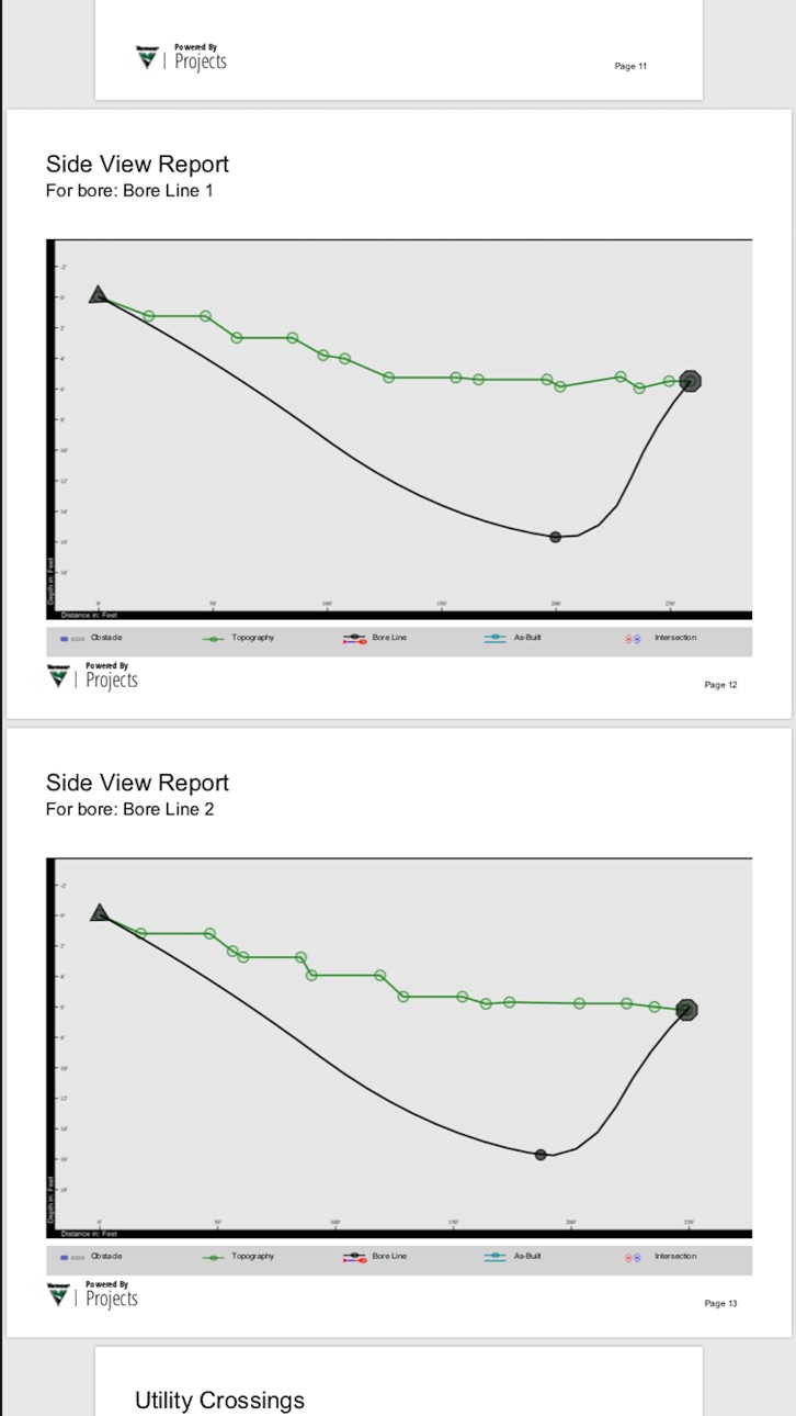
• The bore profile displayed in the side view accounts for drill bit or reamer size to better visualize utility avoidance.
• Utility separation measurements between utilities and bore lines is displayed in the report.
• Improved integration between GPS receivers and Vermeer Projects by displaying more information and added controls in Projects.
Build 830282694v2.2.02019-03-12 15:00:26
New Features
• New Language support for Europe has been added including: Danish, French, and Dutch
• GPS Datum Transformations: added the ability to switch to two additional datum transformations that are used in Europe (ETRS-89) and Australia (GDA2020)
• Users can now add pictures that have been added to the project by selecting the desired image when generating a report
Enhancements
• General improvements and fixes to the reliability and stability of the program
Build 828718631v2.0.1022018-10-01 13:42:34
• Cover Page enhancements to give you more control
• Display custom logos – yours, your client, or other images of interest
• Custom content to personalize or call out items you feel are important
• Dedicated Side View
• Full page landscape view of commonly used report now with legend
• Expanded Import and Export functionality with DXF and CSV file types
• Topography enhancements with choice for Google, Flat, or Custom Imported
• As Built and Rod by Rod table improvements
• Support for additional notes and comments throughout the reporting system
• Added new datums support for additional GPS hardware support
• Customer requested features to align with their work flow
• Increased reliability and stability
Build 828113652v2.0.1012018-08-07 18:18:54
-App load while paired with GPS devices improved
-LWD Transfer list refresh upon transferring files from device has improved
-Stability and reliability improvements
Build 826885779v2.0.952018-05-10 16:57:15
-Enhanced performance when uploading LWD files from a locator
-Offline saving is now permitted
Build 826648606v2.0.932018-04-17 19:55:36
-Enhanced stability when using a connected EOS Arrow device
-Readjusted the screen size for iPhone X
Build 825746534v2.02018-02-01 17:02:09
Application Launch
Build 817605454v1.02016-06-07 19:58:59
No pricing data captured yet — comparisons appear once the app has paid storefronts or in-app purchases.
Availability 35 of 99 storefronts
| Region | Language | Price | Ratings | Avg | Version |
|---|---|---|---|---|---|
| US | en-US | Free | 6 | 4.2 | 2.3.2 |
| AT | de-DE | Free | 0 | — | 2.3.2 |
| AU | en-AU | Free | 0 | — | 2.3.2 |
| BE | en-GB | Free | 0 | — | 2.3.2 |
| BG | en-GB | Free | 0 | — | 2.3.2 |
| CA | en-CA | Free | 0 | — | 2.3.2 |
| CH | de-CH | Free | 0 | — | 2.3.2 |
| CZ | en-GB | Free | 0 | — | 2.3.2 |
| DE | de-DE | Free | 0 | — | 2.3.2 |
| DK | en-GB | Free | 0 | — | 2.3.2 |
| EE | en-GB | Free | 0 | — | 2.3.2 |
| ES | es-ES | Free | 0 | — | 2.3.2 |
| FI | en-GB | Free | 0 | — | 2.3.2 |
| FR | fr-FR | Free | 0 | — | 2.3.2 |
| GB | en-GB | Free | 0 | — | 2.3.2 |
| GR | en-GB | Free | 0 | — | 2.3.2 |
| HR | en-GB | Free | 0 | — | 2.3.2 |
| HU | en-GB | Free | 0 | — | 2.3.2 |
| IE | en-GB | Free | 0 | — | 2.3.2 |
| IS | en-GB | Free | 0 | — | 2.3.2 |
| IT | it | Free | 0 | — | 2.3.2 |
| LT | en-GB | Free | 0 | — | 2.3.2 |
| LU | en-GB | Free | 0 | — | 2.3.2 |
| LV | en-GB | Free | 0 | — | 2.3.2 |
| MK | en-GB | Free | 0 | — | 2.3.2 |
| MT | en-GB | Free | 0 | — | 2.3.2 |
| NL | nl | Free | 0 | — | 2.3.2 |
| NO | en-GB | Free | 0 | — | 2.3.2 |
| NZ | en-AU | Free | 0 | — | 2.3.2 |
| PL | en-GB | Free | 0 | — | 2.3.2 |
| PT | pt-PT | Free | 0 | — | 2.3.2 |
| RO | en-GB | Free | 0 | — | 2.3.2 |
| SE | sv | Free | 0 | — | 2.3.2 |
| SI | en-GB | Free | 0 | — | 2.3.2 |
| SK | en-GB | Free | 0 | — | 2.3.2 |
Not available in: AE, AF, AL, AM, AZ, BA, BH, BM, BN, BT, BY, CN, CY, FJ, FM, GE, HK, ID, IL, IN, IQ, JO, JP, KG, KH, KR, KW, KZ, LA, LK, MD, ME, MM, MN, MO, MR, MV, MY, NP, NR, OM, PG, PH, PK, PW, QA, RS, RU, SA, SB, SG, TH, TJ, TM, TO, TR, TW, UA, UZ, VN, VU, XK, YE, ZA
Change log 12 changes · US
✎
releaseNotes updated
New Features:
• Rod by Rod table information available in the application is now available for export to .csv format.
Enhancements:
• Updated to support latest
✎
description updated
Provide a professional, paperless job record to project owners instead of a stack of papers. Vermeer Projects makes it simple for operations managers to collect
✎
name updated
Vermeer Projects Suite
◆
Version 2.3.2 released
New Features:
• Rod by Rod table information available in the application is now available for export to .csv format.
Enhancements:
• Updated to support latest iOS features.
◆
Version 2.3.0 released
New Features:
• Elevation data is now being collected from GPS receivers.
• The accuracy of that lat/long and elevation of the collected data points from connected GPS receivers is now captured and displayed.
• A bore profile can use an ent
◆
Version 2.2.0 released
New Features
• New Language support for Europe has been added including: Danish, French, and Dutch
• GPS Datum Transformations: added the ability to switch to two additional datum transformations that are used in Europe (ETRS-89) and Austra
◆
Version 2.0.102 released
• Cover Page enhancements to give you more control
• Display custom logos – yours, your client, or other images of interest
• Custom content to personalize or call out items you feel are important
• Dedicated Side View
◆
Version 2.0.101 released
-App load while paired with GPS devices improved
-LWD Transfer list refresh upon transferring files from device has improved
-Stability and reliability improvements
◆
Version 2.0.95 released
-Enhanced performance when uploading LWD files from a locator
-Offline saving is now permitted
◆
Version 2.0.93 released
-Enhanced stability when using a connected EOS Arrow device
-Readjusted the screen size for iPhone X
◆
Version 2.0 released
Application Launch
◆
Version 1.0 released