Home › Business

 US
US
1 of 1 storefronts
Content in en-US
Content in en-US
Information
Preview 2 platforms
iPhone 6 images


iPad 5 images



What’s New Version 10.1.1
What’s new (v10.1.1)
- Fixed Wi-Fi connectivity to LN-series on iOS devices
What’s new (v10.1)
- Added support for bundle activation (pilot phase)
- Bug fixes and stability improvements.
(Bundle activation will be rolled out more broadly in a future update. There is no impact to current activation workflow.)
What's new (v10.0)
- Added support for TILT in Hybrid Positioning mode. TILT functions now also available for optical measurements when in hybrid mode
- Integration with ESRI ArcGIS
- 3D models, added support for 3D models
- Added support for depth sounder
- Added Topo Surface routine
- Added full support for string roads
Description
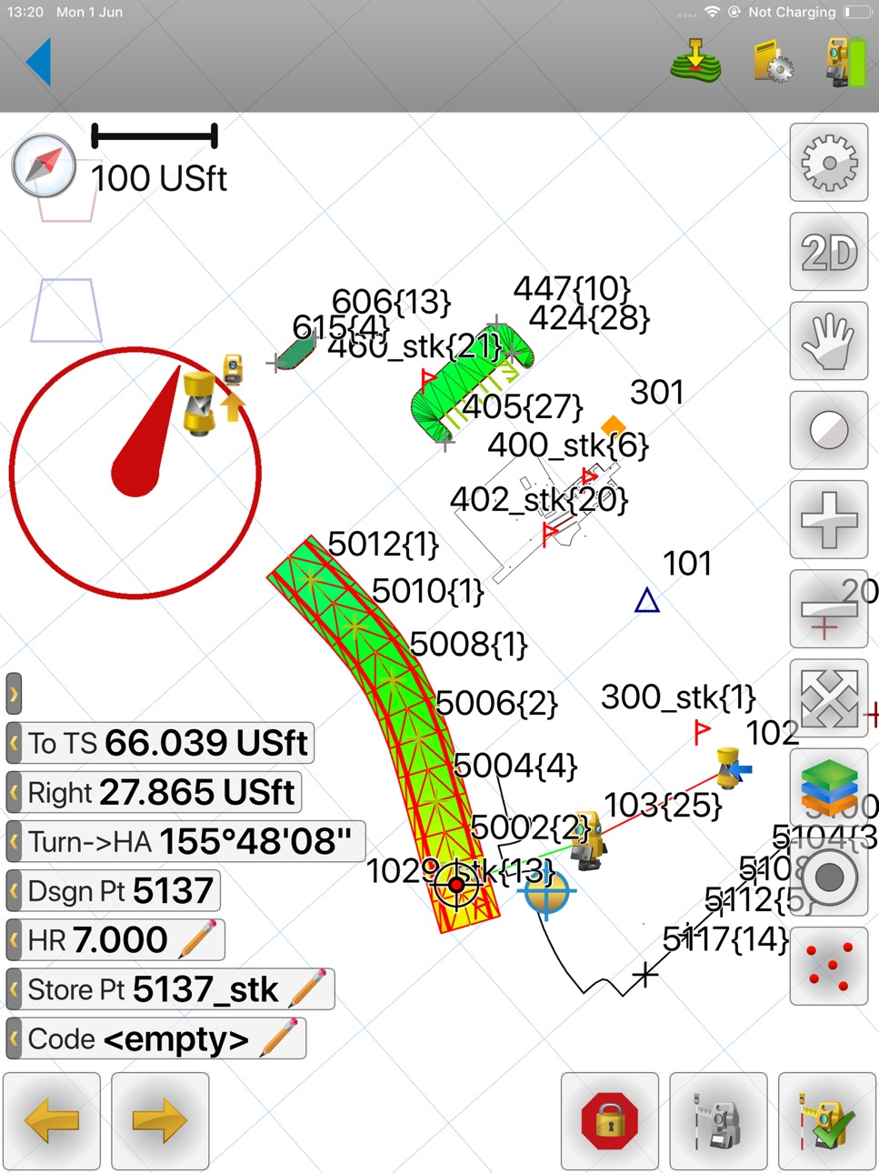
Topcon Field Mobile app is focused and ready to drive Topcon/Sokkia Total Stations and GNSS receives for precise design layout needs as well as quick and intuitive options for field measurements.
Topcon Field Mobile provides assisted navigation to any point, line/area, surface or feature on your project site through constant real time positioning.
Topcon Field Mobile also offers instant ability to securely login to your private Company Account within the MAGNET system to exchange files while standing at active projects sites.
Accessibility
ipadiphonemacrealityDevicetvoswatch
Version history 22 versions
Build 887328663v10.1.12026-06-25 07:29:01
What’s new (v10.1.1)
- Fixed Wi-Fi connectivity to LN-series on iOS devices
What’s new (v10.1)
- Added support for bundle activation (pilot phase)
- Bug fixes and stability improvements.
(Bundle activation will be rolled out more broadly in a future update. There is no impact to current activation workflow.)
What's new (v10.0)
- Added support for TILT in Hybrid Positioning mode. TILT functions now also available for optical measurements when in hybrid mode
- Integration with ESRI ArcGIS
- 3D models, added support for 3D models
- Added support for depth sounder
- Added Topo Surface routine
- Added full support for string roads
Build 881713639v10.1.02026-05-11 12:33:53
What’s new (v10.1)
- Added support for bundle activation (pilot phase)
- Bug fixes and stability improvements.
(Bundle activation will be rolled out more broadly in a future update. There is no impact to current activation workflow.)
What's new (v10.0)
- Added support for TILT in Hybrid Positioning mode. TILT functions now also available for optical measurements when in hybrid mode
- Integration with ESRI ArcGIS
- 3D models, added support for 3D models
- Added support for depth sounder
- Added Topo Surface routine
- Added full support for string roads
Build 879288900v10.0.02026-01-13 12:12:47
• Added support for TILT in Hybrid Positioning mode. TILT functions now also available for optical measurements when in hybrid mode
• Integration with ESRI ArcGIS
• 3D models, added support for 3D models
• Added support for depth sounder
• Added Topo Surface routine
• Added full support for string roads
Build 872159564v9.1.02025-03-18 17:33:22
With the release of Topcon Field Mobile v9.1, we have made some minor modifications to the User Interface. These enhancements do not impact configurations or product performance. Your product experience with the Topcon Field solution remains the same reliable experience that you know and expect from Topcon.
Topcon Field Mobile is a simple-to-use positioning control software for iOS devices.
Whether you are a professional surveyor or a contractor, Topcon Field Mobile is going to make your life much easier when setting out or collecting points on your next job.
The V9.1 update introduces powerful, time-saving features and enhancements designed to maximize the efficiency of Topcon positioning hardware, helping users tackle any challenges at their next project site with ease.
Topcon Field Mobile v9.1 added highlights.
• Support of new GNSS receivers Topcon Hiper XR and Sokkia GRX5 and all their features.
• Mock Location issues have been resolved.
• Resection residuals are now available as angles and/or coordinates.
• Imported CAD background points can be selected from map during Total Station Set up routines.
• Several import and export issues have been resolved.
• Improved text field modifications.
• Show current position is now available in the Map Settings for the main map.
• Improved Projection and Geoid support.
Build 869955061v9.0.02024-11-28 09:10:31
With the release of Topcon Field Mobile V9.0, we have made some minor modifications to the User Interface. These enhancements do not impact configurations or product performance. Your product experience with the Topcon Field solution remains the same reliable experience that you know and expect from Topcon.
Topcon Field Mobile is a simple-to-use positioning control software for iOS devices.
Whether you are a professional surveyor or a contractor, Topcon Field is going to make your life much easier when setting out or collecting points on your next job.
The V9.0 update introduces powerful, time-saving features and enhancements designed to maximize the efficiency of Topcon positioning hardware, helping users tackle any challenges at their next project site with ease.
Topcon Field Mobile V9 added highlights.
• UI modifications to match the rebranding from MAGNET to Topcon.
• Added Roading functionality, similar to Field for Windows features and operation.
• Updated Skybridge support improves user workflows and convergence times.
• Improved TILT support for GNSS receivers that support TILT.
• Added Scanning options for Robotic Total Stations that support Scanning.
• Enhanced TOPO menu to include additional data collection options.
• Multiple improvements and options added to COGO and Instrument Setup.
• Improved Projection and Geoid support.
Build 863678112v8.1.02024-03-20 22:41:13
• Added support for RTCM SC135 protocol for the Topcon R2Lite UHF radio
• In the GNSS Status, Renamed "H/V" to "HRMS/VRMS" to improved usability.
• Added the option to hide obsolete coordinate systems. The ‘Show legacy CS’ option is now available in the Coordinate System > Advanced Settings. Users can opt to show or hide legacy Coordinate System options in the list.
• Added the option to select a line or linework and get info about the layer it resides in.
• For Lines or Linework, when in Stake and Topo, added the option to configure "Value to Display" (point number, code, code description etc) for line code.
• Added Latvian language support
Build 860430978v8.0.02023-11-22 09:04:56
MAGNET Field added highlights.
• Graphical and intuitive positioning software
• SureTopo™: outlier detection feature for RTK Topo surveys.
• Shared data file for control and codes. Store the shared data file on your controller and use on any job.
• Additional GNSS and Optical setup and offset measurement options added.
• Additional stakeout routines added.
• Improved Import and Export format support.
• Many new features and improvements added. See release notes for details.
https://www.topconpositioning.com/na/support/updates/MAGNET_Construct
Build 851614605v5.3.12022-08-17 17:41:14
Updated languages
Build 849235171v5.3.02022-07-04 13:47:46
MAGNET Construct is a simple-to-use positioning control software. Whether you are a professional surveyor or a contractor, MAGNET Construct is going to make your life much easier when setting out or collecting points on your next job.
Build 846007295v5.2.02022-01-15 00:15:02
WHAT'S NEW
MAGNET Construct is a simple-to-use positioning control software. With MAGNET Construct, the workflow is simple, the features are ever-growing, and the capabilities for precise positioning are in the palm of your hand. Whether you are a professional surveyor or a contractor, MAGNET Construct is going to make your life much easier when setting out or collecting points on your next job.
New in MAGNET Construct 5.2
• Post-process data collection support with storage on the controller or GNSS internal memory
• Updated Coordinate System support, including RTCM Online transformation
See the Release notes posted on MyTopcon.com for additional details.
Build 841682790v5.1.02021-09-28 23:11:54
New in MAGNET Construct 5.1
Added TS/GNSS Raw Data support
Improved support for managing GNSS receivers.
Improved Total Station support for ‘Setup for 3DMC’
Improved Stakeout navigation compass
Added the option to Scale a PDF on import
Improved Map display options
See the Release notes posted on MyTopcon.com for additional details.
Build 837450878v4.1.02020-09-21 08:46:17
New Major Features
MAGNET Construct V4.1 now includes support for MAGNET Vision companion app. Visit http://www.TopconPositioning.com to learn more.
Added Enter Plan
Added support for the new Topcon/ Sokkia GT/iX 600/1200 Robotic Total Stations.
Added support for Topcon/Sokkia Motorized Total Stations
Added support for Topcon/Sokkia Conventional Total Stations
Added the option to Import and export data between jobs.
Added the option to select Data type on import and export.
Other Features
Added the option to combine and export reports as a PDF
Change point name in Topo is now done with 2 clicks.
Added the option to select linework and reverse the direction of the line.
Added the option to reorder quick codes.
Added the option to configure the laser pointer and guide light in the default optical settings.
Added Hungarian language
Build 836210344v4.0.02020-06-02 06:08:15
New Look and Feel
- Configurable, icon based main menu
- New app themes, Dark and Light
- All Topcon and Sokkia instruments got unique icons
- Added Global Options for UI Scale/Text size
Codes support
- Add/Edit/Delete Codes, Attributes, Code Strings & Control Codes
- Global Code Library
- Persistence settings
- Quick Codes
- Import/export
Linework/Areas support
- Add/Edit/Delete Linework and Areas
- Automatic creation based on Codes/Code Strings/Control Codes
- Fast Editing in Topo using Custom Text Fields
- 2D/3D Area calculation for areas
- Import/Export
Surfaces support
- Add/Edit/Delete surfaces
- Create contour lines for a surface
- Create surface from points and lines
- Import/export
Map improvements
- General improvements in 2D/3D map
- Customizable Favorites menu on the Map screen
- Allow user to generate surface points from the Map
- Added Custom Text Fields to Stake and Topo for new data types and routines
- Add the option "Create a field report" from the map
New features in Stake/Layout
- Stakeout of Surface and Linework
- Optional Reference CL, plane and/or surface
- Extending an existing ground or cut/fill surface in Stake Surface
- Stake Curve
- Added offsets to Stake Line, Curve and Linework
New in Coordinate Systems
- Swedish Geoid
- New Iowa projections
- Improved RTCM support
- An ability to download Geoids from cloud storage
- Import/Export localization to GC3
New in Hardware support
- Added LN-150
- Topcon BLE protocol v2.0
- Support SBAS for new Topcon receivers
- Added "Connecting to devices on startup"
- Added LN-100 simulator
- Added an ability to setup NMEA output on Topcon receivers
- Selection of country in the provider list
Setup Routines
- Hybrid Resection
- Added possibility to use non-existing points in Hybrid mode if the pre-defined grid projection was selected
- Added an ability to select a point from the map when performing a resection
- Set Elevation routine, with joystick control and an ability to store points
Compatibility
- Full compatibility with MAGNET 6.x suite (mjf and MaXML 1.4)
- Files application support on iOS
Other
- New Field Report images editor
- Extended Point List functionality: Copy Point, Sort and Find functions
- AutoCAD DWG 2019 supported for import
Build 832235523v3.1.12019-08-05 06:13:19
German, French and Korean translations.
Build 831399985v3.12019-06-04 14:37:51
3.1
Updated translations for Russian, Spanish, Chinese and Japanese languages.
3.0.1
UI improvements for iPhone X and iPhone Xs
3.0
New look and feel
Construction/Surveying terminology switch
Full compatibility with MAGNET 5.x suite
Support Topcon and Sokkia GNSS receivers:
- Corrections via Radios and Cell (NTRIP and direct TCP/IP)
- RTK, DGPS
- LongLink™ and LongRange™ communication support
- Support BLE for HiPer VR, GCX3, HiPer HR (requires fw update)
- Support GPS integrated into phone
Support Hybrid™ for Topcon and Fusion™ for Sokkia equipment
Full support of coordinate systems including custom projections, custom datums, geoids and localization
Support most of available Web Map Services as background map
New and Updated Import/Export formats:
- MAGNET XML (*.mxl, *.mxlzip)
- Topcon 3DMC (*.tp3)
- AutoCAD Drawing (*dwg)
- AutoCAD DXF (*.dxf)
- ESRI shape zipped
- LandXML (1.0, 1.2, 2.0) (*.xml)
- SIMA, SIMA Index (*.SIM)
Deviation reports customization
Seamless job backup to cloud
Improved performance for big projects
Editable layers
Multiple background drawings support
Map moving direction/rotation support
Improved stakeout control
Improved 3D map
Build 830833801v3.0.12019-04-03 05:30:23
3.0.1
UI improvements for iPhone X and iPhone Xs
3.0
New look and feel
Construction/Surveying terminology switch
Full compatibility with MAGNET 5.x suite
Support Topcon and Sokkia GNSS receivers:
- Corrections via Radios and Cell (NTRIP and direct TCP/IP)
- RTK, DGPS
- LongLink™ and LongRange™ communication support
- Support BLE for HiPer VR, GCX3, HiPer HR (requires fw update)
- Support GPS integrated into phone
Support Hybrid™ for Topcon and Fusion™ for Sokkia equipment
Full support of coordinate systems including custom projections, custom datums, geoids and localization
Support most of available Web Map Services as background map
New and Updated Import/Export formats:
- MAGNET XML (*.mxl, *.mxlzip)
- Topcon 3DMC (*.tp3)
- AutoCAD Drawing (*dwg)
- AutoCAD DXF (*.dxf)
- ESRI shape zipped
- LandXML (1.0, 1.2, 2.0) (*.xml)
- SIMA, SIMA Index (*.SIM)
Deviation reports customization
Seamless job backup to cloud
Improved performance for big projects
Editable layers
Multiple background drawings support
Map moving direction/rotation support
Improved stakeout control
Improved 3D map
Build 830568977v3.02019-03-29 22:24:13
* New look and feel
* Construction/Surveying terminology switch
* Full compatibility with MAGNET 5.x suite
* Support Topcon and Sokkia GNSS receivers
- Corrections via Radios and Cell (NTRIP and direct TCP/IP)
- RTK, DGPS
- LongLink™ and LongRange™ communication support
- Support BLE for HiPer VR, GCX3, HiPer HR (requires fw update)
- Support GPS integrated into phone
* Support Hybrid™ for Topcon and Fusion™ for Sokkia equipment
* Full support of coordinate systems including custom projections, custom datums, geoids and localization
* Support most of available Web Map Services as background map
* New and Updated Import/Export formats
- MAGNET XML (*.mxl, *.mxlzip)
- Topcon 3DMC (*.tp3)
- AutoCAD Drawing (*dwg)
- AutoCAD DXF (*.dxf)
- ESRI shape zipped
- LandXML (1.0, 1.2, 2.0) (*.xml)
- SIMA, SIMA Index (*.SIM)
* Deviation reports customization
* Seamless job backup to cloud
* Improved performance for big projects
* Editable layers
* Multiple background drawings support
* Map moving direction/rotation support
* Improved stakeout control
* Improved 3D map
Build 820470632v2.12017-05-12 16:46:10
Updated translations, stability improvements.
Build 819479754v2.02017-01-02 19:50:30
Instruments:
- New instruments are supported.
- Extra options for configuring Lemans instrument.
- Instrument version is shown in Job Info.
- Simulator mode.
- Joystick for controlling instrument is improved.
- Clicking Joystick allows to precisely control instrument.
- Instrument battery status indicator is shown.
- Continuous reflectorless measurement option is available.
Map:
- New map properties options.
- Improved pan & zoom control for 3D map.
- Support different projections for 3D map (Perspective, Front, Top).
- Text appearance on 3D map is improved.
As-built:
- User can specify point name.
- Customizable labels with measurements.
- "Find Me Here" option is available in context menu.
Layout:
- Map orientation options.
- Zoom screen in when switch to the bullseye mode.
- Guidance arrow is shown.
- Rotate to point from the map.
Import/Export:
- Support new formats
SIMA(*.sim)
MicroStation V8 (*.dgn)
MAGNET XML (*.mxl)
- Allow to select "file units" on import/export.
Cloud and Exchange:
- Support folders.
- Open job after downloading.
- History dialog.
- Option to upload current job.
Miscellaneous:
- Occupation Reports are available.
- Redesigned Edit Points list.
- MJF database format is unified with MAGNET 4.0.
- Automatic recomputation.
- Japanese language is available now.
Build 814300698v1.6.12015-12-01 01:34:57
Added languages: Croatian, Italian, Spanish.
Improved list scrolling.
Build 813225427v1.6.02015-10-19 20:59:22
iOS 9 compatibility.
Support for new MAGNET Enterprise Data Manager.
Stability and performance improvements in 3D Map, DXF support and other areas.
Build 813077353v1.5.02015-08-28 22:22:43
No pricing data captured yet — comparisons appear once the app has paid storefronts or in-app purchases.
Availability 1 of 1 storefronts
| Region | Language | Price | Ratings | Avg | Version |
|---|---|---|---|---|---|
| US | en-US | Free | 17 | 3.5 | 10.1.1 |
Change log 25 changes · US
✎
releaseNotes updated
What’s new (v10.1.1)
- Fixed Wi-Fi connectivity to LN-series on iOS devices
What’s new (v10.1)
- Added support for bundle activation (pilot phase)
- Bug fixes
✎
description updated
Topcon Field Mobile app is focused and ready to drive Topcon/Sokkia Total Stations and GNSS receives for precise design layout needs as well as quick and intuit
✎
name updated
Topcon Field Mobile
◆
Version 10.1.1 released
What’s new (v10.1.1)
- Fixed Wi-Fi connectivity to LN-series on iOS devices
What’s new (v10.1)
- Added support for bundle activation (pilot phase)
- Bug fixes and stability improvements.
(Bundle activation will be rolled out more broadly i
◆
Version 10.1.0 released
What’s new (v10.1)
- Added support for bundle activation (pilot phase)
- Bug fixes and stability improvements.
(Bundle activation will be rolled out more broadly in a future update. There is no impact to current activation workflow.)
What
◆
Version 10.0.0 released
• Added support for TILT in Hybrid Positioning mode. TILT functions now also available for optical measurements when in hybrid mode
• Integration with ESRI ArcGIS
• 3D models, added support for 3D models
• Added support for depth sounder
◆
Version 9.1.0 released
With the release of Topcon Field Mobile v9.1, we have made some minor modifications to the User Interface. These enhancements do not impact configurations or product performance. Your product experience with the Topcon Field solution remai
◆
Version 9.0.0 released
With the release of Topcon Field Mobile V9.0, we have made some minor modifications to the User Interface. These enhancements do not impact configurations or product performance. Your product experience with the Topcon Field solution remai
◆
Version 8.1.0 released
• Added support for RTCM SC135 protocol for the Topcon R2Lite UHF radio
• In the GNSS Status, Renamed "H/V" to "HRMS/VRMS" to improved usability.
• Added the option to hide obsolete coordinate systems. The ‘Show legacy CS’ option is now
◆
Version 8.0.0 released
MAGNET Field added highlights.
• Graphical and intuitive positioning software
• SureTopo™: outlier detection feature for RTK Topo surveys.
• Shared data file for control and codes. Store the shared data file on your controller and
◆
Version 5.3.1 released
Updated languages
◆
Version 5.3.0 released
MAGNET Construct is a simple-to-use positioning control software. Whether you are a professional surveyor or a contractor, MAGNET Construct is going to make your life much easier when setting out or collecting points on your next job.
◆
Version 5.2.0 released
WHAT'S NEW
MAGNET Construct is a simple-to-use positioning control software. With MAGNET Construct, the workflow is simple, the features are ever-growing, and the capabilities for precise positioning are in the palm of your hand. Whether yo
◆
Version 5.1.0 released
New in MAGNET Construct 5.1
Added TS/GNSS Raw Data support
Improved support for managing GNSS receivers.
Improved Total Station support for ‘Setup for 3DMC’
Improved Stakeout navigation compass
Added the option to Scale a PDF on import
◆
Version 4.1.0 released
New Major Features
MAGNET Construct V4.1 now includes support for MAGNET Vision companion app. Visit http://www.TopconPositioning.com to learn more.
Added Enter Plan
Added support for the new Topcon/ Sokkia GT/iX 600/1200 Robotic Tot
◆
Version 4.0.0 released
New Look and Feel
- Configurable, icon based main menu
- New app themes, Dark and Light
- All Topcon and Sokkia instruments got unique icons
- Added Global Options for UI Scale/Text size
Codes support
- Add/Edit/Delete Codes, A
◆
Version 3.1.1 released
German, French and Korean translations.
◆
Version 3.1 released
3.1
Updated translations for Russian, Spanish, Chinese and Japanese languages.
3.0.1
UI improvements for iPhone X and iPhone Xs
3.0
New look and feel
Construction/Surveying terminology switch
Full compatibility with MAGNET 5.x suite
Suppo
◆
Version 3.0.1 released
3.0.1
UI improvements for iPhone X and iPhone Xs
3.0
New look and feel
Construction/Surveying terminology switch
Full compatibility with MAGNET 5.x suite
Support Topcon and Sokkia GNSS receivers:
- Corrections via Radios and Cell (NTRIP an
◆
Version 3.0 released
* New look and feel
* Construction/Surveying terminology switch
* Full compatibility with MAGNET 5.x suite
* Support Topcon and Sokkia GNSS receivers
- Corrections via Radios and Cell (NTRIP and direct TCP/IP)
- RTK, DGPS
- Long
◆
Version 2.1 released
Updated translations, stability improvements.
◆
Version 2.0 released
Instruments:
- New instruments are supported.
- Extra options for configuring Lemans instrument.
- Instrument version is shown in Job Info.
- Simulator mode.
- Joystick for controlling instrument is improved.
- Clicking Joystick allows to p
◆
Version 1.6.1 released
Added languages: Croatian, Italian, Spanish.
Improved list scrolling.
◆
Version 1.6.0 released
iOS 9 compatibility.
Support for new MAGNET Enterprise Data Manager.
Stability and performance improvements in 3D Map, DXF support and other areas.
◆
Version 1.5.0 released