Home › Navigation

 US
US
1 of 1 storefronts
Content in en-US
Content in en-US
Information
Preview 2 platforms
iPhone 10 images




iPad 5 images


What’s New Version 1.2.8
Fixed bugs
Description
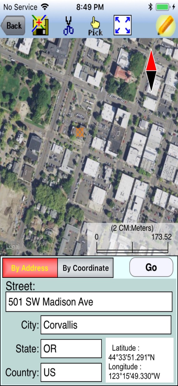
iCMTGIS PRO is a professional GPS/GIS mapping, data collection and stakeout app for use on the iPad and iPhone devices. It can be used to effectively collect data and increase productivity for utilities, wildlife, natural resources, land management, surveying, soil study, archaeology, drone control points and other land-based or air-borne GPS/GIS applications. LLA, UTM, State Plane and local coordinate systems supported. It also provides the ability to create a local NEZ coordinate system to use with real-world designs on paper.
Requires iOS 9 or newer version of iOS.
iCMTGIS PRO will work with any iOS compatible GPS devices. In addition, it is able to display the GPS status for a few specific external GPS receivers and record accuracy and quality information for the recorded position - e.g. EOS Arrow Gold, Geneq SXBlue Platinum, Juniper Systems Geod. When used with these GPS receivers, you will be able to set PDOP mask and RMS limit for quality assurance. iCMTGIS PRO can make use of the NGS Geoid12a binary files. It can be a valuable RTK data collection and stakeout tool when used with a compatible GPS receiver that outputs the needed accuracy information.
iCMTGIS PRO will let you define a custom Feature-Attribute database to facilitate data collection. It will let you log GPS Points, Lines and Area Features and tag them with predefined or manually added descriptions. It will let you log multiple GPS fixes and automatically calculate the average position. It will let you record nested Points while recording a Line or Area Feature. It will also let you digitize Features on top of a background map or create traverse points by entering angles and distances. You may load a GeoTiff image to use as a static or moving background map. You can record your track while performing other tasks using this app. Enter deed calls to create a deed plot. View distances and areas on the spot. Create buffers. Create a grid over an area. Crate contour lines based on points with (x,y,z) coordinates. Attach photos. Easily import/export Shapefiles, Excel files, DXF files, KML files and text files, send/receive files via ftp or email, and store files in the Cloud. Generate and view PDF files. The app comes with a detailed built-in help document. Free relevant GPS/GIS training videos are provided on the Internet.
iCMTGIS PRO provides Point Stakeout as well as Line Stakeout functionality to help you get to a specific Point or to move along a pre-defined Line or perimeter.
iCMTGIS PRO is a one-time purchase without any annual subscription fees. It will run on iPad devices as well as iPhone devices.
Please note: Location data depends on the GPS receiver used. Continued use of GPS running in the background can dramatically decrease battery life. iCMTGIS PRO will let you easily toggle the GPS on or off.
Accessibility
ipadiphonemacrealityDevicetvoswatch
Version history 25 versions
Build 886843413v1.2.82026-06-24 05:44:05
Fixed bugs
Build 872880088v1.2.72025-03-01 23:28:34
Fixed bugs
Build 863661580v1.2.52024-02-16 20:28:35
Fixed bugs related to Create Grid and displaying the segment lengths for deed plots.
Build 861626716v1.2.42023-12-11 23:24:46
iOS 17 compatibility
Build 856024661v1.2.32023-09-02 23:22:18
Fixed issue that caused the error message "number of shapes does not match the number of table records" to be generated when trying to open exported Shapefiles in ArcMap. This error occurred with Job files that contain digitized Features without assigned Attribute Values.
Build 855693769v1.2.22023-03-24 22:31:26
Fixed compatibility issues caused by the screen size of the various newer iOS device models.
Build 855014576v1.2.12023-02-23 17:36:39
Addressed compatibility issues for the newer iOS devices with various display sizes.
Build 850899991v1.2.02022-11-14 22:15:31
Fix 9th generation device compatibility issue
Build 850021452v1.1.92022-06-23 17:22:17
1. Enables the app to work properly with the 9th generation iPad devices.
2. Includes an update of the Geode device protocol and provides the ability to select the new Geode GNS3 in the "Enable the External GPS" mode.
Build 847315163v1.1.82022-03-26 01:23:06
Fixed issue related to iOS versions newer than 15.0 - the app crashing after recording a Line or Area Feature.
Build 842136113v1.1.72021-10-30 16:29:29
Permit DXF attached to an email to be opened by the app.
Build 838461529v1.1.62021-03-14 17:38:01
Display the contents of Feature List used by a Job when iCloud storage is selected for storing Job and Feature List data.
Change the default settings in the "Enable the external GPS" mode.
Build 836931603v1.1.52020-08-05 01:38:33
For importing from an Excel file, added the ability to detect decimal numbers used as Feature IDs.
Build 834337713v1.1.42020-04-02 19:52:34
Fixed bug relating to symbol used for GPS data collection.
Build 834090085v1.1.32019-12-30 18:41:25
Added RMS to the Built-in Attribute List.
Build 833223666v1.1.22019-11-06 20:26:00
1. Added GPS Data Quality as a built-in Attribute.
2. Fixed the problem of not automatically recording the default Value for the first Feature in a Topic.
3. Fixed bugs related to adding H_2DRMS as a Feature Topic Attribute.
Build 829886826v1.1.12019-02-02 20:23:41
Fixed document configuration issue.
Build 829654089v1.1.02018-12-18 17:10:58
1. Fixed missing fields on Datum page under Setup GPS.
2. Promptly display the Attribute page in the iPhone version.
3. Fixed inactive links in the Help document.
Build 829154696v1.092018-11-08 14:52:37
Moved the icons at the top so they won't run into the controls on the iPhone X, iPhone R, iPhone XS, and iPhone XS Max devices.
Enhanced the text file import and export. Whereas text file import was limited to importing text files ending in .txt, now the user may select between .txt and .csv. For text file export, we've added a window to let the user select the Attributes to be exported instead of exporting all of the Attributes for the Topic.
Build 828702333v1.0.82018-09-26 15:32:35
Fixed bugs involving downloading files from iCloud.
Build 828468222v1.0.72018-09-15 17:33:02
1. Added RMS value to Built-in Attribute List so that it can be exported.
2. Fixed the bug of not creating the .prj file when exporting to Shapefiles from the NAD83(2011) coordinate system.
Build 822418921v1.0.62017-06-13 17:58:57
Fixed problem displaying geoid separation file used
Build 822331542v1.052017-06-01 17:59:30
Added display of the name of the geoid file used in computing MSL.
Build 821966381v1.0.42017-05-03 20:58:53
Added WGS84(1674)/ITRF08 and NAD83(2011) datum selections.
Fixed issue with importing previously exported data in Excel file format.
Build 818172280v1.0.32016-07-18 18:09:20
Fixed bug in Position Info display.
Price history by region
Currency
Show
Columns
Search
Availability 1 of 1 storefronts
| Region | Language | Price | Ratings | Avg | Version |
|---|---|---|---|---|---|
| US | en-US | USD 299.99 | 7 | 4.9 | 1.2.8 |
Change log 29 changes · US
✎
releaseNotes updated
Fixed bugs
✎
description updated
iCMTGIS PRO is a professional GPS/GIS mapping, data collection and stakeout app for use on the iPad and iPhone devices. It can be used to effectively collect da
✎
subtitle updated
GPS Data Collection & Mapping
✎
name updated
iCMTGIS PRO
◆
Version 1.2.8 released
Fixed bugs
◆
Version 1.2.7 released
Fixed bugs
◆
Version 1.2.5 released
Fixed bugs related to Create Grid and displaying the segment lengths for deed plots.
◆
Version 1.2.4 released
iOS 17 compatibility
◆
Version 1.2.3 released
Fixed issue that caused the error message "number of shapes does not match the number of table records" to be generated when trying to open exported Shapefiles in ArcMap. This error occurred with Job files that contain digitized Features wi
◆
Version 1.2.2 released
Fixed compatibility issues caused by the screen size of the various newer iOS device models.
◆
Version 1.2.1 released
Addressed compatibility issues for the newer iOS devices with various display sizes.
◆
Version 1.2.0 released
Fix 9th generation device compatibility issue
◆
Version 1.1.9 released
1. Enables the app to work properly with the 9th generation iPad devices.
2. Includes an update of the Geode device protocol and provides the ability to select the new Geode GNS3 in the "Enable the External GPS" mode.
◆
Version 1.1.8 released
Fixed issue related to iOS versions newer than 15.0 - the app crashing after recording a Line or Area Feature.
◆
Version 1.1.7 released
Permit DXF attached to an email to be opened by the app.
◆
Version 1.1.6 released
Display the contents of Feature List used by a Job when iCloud storage is selected for storing Job and Feature List data.
Change the default settings in the "Enable the external GPS" mode.
◆
Version 1.1.5 released
For importing from an Excel file, added the ability to detect decimal numbers used as Feature IDs.
◆
Version 1.1.4 released
Fixed bug relating to symbol used for GPS data collection.
◆
Version 1.1.3 released
Added RMS to the Built-in Attribute List.
◆
Version 1.1.2 released
1. Added GPS Data Quality as a built-in Attribute.
2. Fixed the problem of not automatically recording the default Value for the first Feature in a Topic.
3. Fixed bugs related to adding H_2DRMS as a Feature Topic Attribute.
◆
Version 1.1.1 released
Fixed document configuration issue.
◆
Version 1.1.0 released
1. Fixed missing fields on Datum page under Setup GPS.
2. Promptly display the Attribute page in the iPhone version.
3. Fixed inactive links in the Help document.
◆
Version 1.09 released
Moved the icons at the top so they won't run into the controls on the iPhone X, iPhone R, iPhone XS, and iPhone XS Max devices.
Enhanced the text file import and export. Whereas text file import was limited to importing text files ending i
◆
Version 1.0.8 released
Fixed bugs involving downloading files from iCloud.
◆
Version 1.0.7 released
1. Added RMS value to Built-in Attribute List so that it can be exported.
2. Fixed the bug of not creating the .prj file when exporting to Shapefiles from the NAD83(2011) coordinate system.
◆
Version 1.0.6 released
Fixed problem displaying geoid separation file used
◆
Version 1.05 released
Added display of the name of the geoid file used in computing MSL.
◆
Version 1.0.4 released
Added WGS84(1674)/ITRF08 and NAD83(2011) datum selections.
Fixed issue with importing previously exported data in Excel file format.
◆
Version 1.0.3 released
Fixed bug in Position Info display.