Home › Utilities

 US
US
 NOen-GB
 BGen-GB
 CZen-GB
 DEde-DE
 GBen-GB
 LTen-GB
 LVen-GB
 NLnl
NLnl PLen-GB
 RSen-GB
 SEsv
SEsv SKen-GBUSen-US
 AENot Available
 ALNot Available
 AMNot Available
 ATNot Available
 AUNot Available
 AZNot Available
 BANot Available
 BENot Available
 BHNot Available
 BYNot Available
 CANot Available
 CHNot Available
 CNNot Available
 CYNot Available
 DKNot Available
 EENot Available
 EGNot Available
 ESNot Available
 FINot Available
 FRNot Available
 GENot Available
 GRNot Available
 HKNot Available
 HRNot Available
 HUNot Available
 IDNot Available
 IENot Available
 ILNot Available
 INNot Available
 IQNot Available
 ISNot Available
 ITNot Available
 JONot Available
 JPNot Available
 KRNot Available
 KWNot Available
 LBNot Available
 LUNot Available
 MDNot Available
 MENot Available
 MKNot Available
 MONot Available
 MTNot Available
 MYNot Available
 NZNot Available
 OMNot Available
 PHNot Available
 PTNot Available
 QANot Available
 RONot Available
 RUNot Available
 SANot Available
 SGNot Available
 SINot Available
 THNot Available
 TRNot Available
 TWNot Available
 UANot Available
 VNNot Available
 XKNot Available
 YENot Available
13 of 74 storefronts
Content in en-US
Content in en-US
Information
Preview 2 platforms
iPhone 7 images



iPad 5 images


What’s New Version 2.9
- Updated crash logging functionality
- Bug fixes
Description
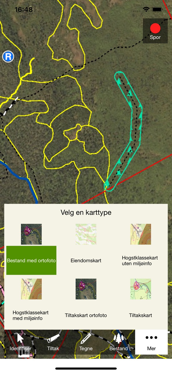
Allma app is a map application that helps to solve tasks for forest owners, officials and entrepreneurs. This version has a lot of new functions. You can log into your forest management plan, your region or your mission. You can activate the GPS to find out where you are in the terrain. Insert a point in the position you are in or make a tracklog. You can edit the stand comment, add new action and edit existing actions. It’s also possible to measure length and area. You ca draw point, line and polygon.
You can choose various map types for your needs. A keystroke in a stand brings up all constituent information.
All functionality is available both online and offline. This makes it possible to use the app in areas without mobile coverage.
Registrations you make in the solution are synchronized into the Allma-database. The next time you log into the web solution, the registrations from the app will be visible.
Continued use of GPS running in the background can dramatically decrease battery life.
Accessibility
ipadiphonemacrealityDevicetvoswatch
Version history 15 versions
Build 838938517v2.92020-11-11 22:48:51
- Updated crash logging functionality
- Bug fixes
Build 836798351v2.82020-07-15 20:35:01
Problems were experienced with particularly long track logs which led to a hang on the solution. This is now fixed
Build 834480810v2.72020-01-27 08:46:23
New development and improvements:
Improved user friendly choice of object types when drawing or edit
The app stays in offline mode when completely closes and opened again
Possibility to centre the map while using tracking
Favourite drawing for contractor
Build 831467911v2.62019-05-29 14:06:53
Bugfix
Build 829645188v2.52018-12-17 16:31:47
Function to make buffer on points, lines and polygons
- The most common object types used are at the top of the list when you select
- Function to use the search result
- Property search for forestry manager
- Improvement of offline sync synchronization function
- Bug-fix »
Build 827716058v2.42018-07-02 08:07:06
New tool for cutting actions, polygons and lines
Improvements to offline functionality
Changes in sync setup
GPS improvements
HTTPS is introduced
Some improvements on user experience
Bug fixes
Build 824347425v2.32017-11-22 06:30:50
The version comes with the following changes:
- Improved solution for identifying action and objects. This gives less clicks and better user experience
- You can now in offline-mode zoom more into the map
- Improvement of menus
- Bug fixes and performance improvements
Build 822816362v2.22017-07-09 11:30:50
Performance and bugfix
Length of tracklog
Improvements to using offline
Build 821479435v2.12017-03-30 08:34:41
Bug fixes
Build 821346738v2.02017-03-24 06:11:17
There are many news in this solution:
The new operating plan that makes it possible to use Allmen app to plan and implement operational - and silviculture mission.
Opportunities to create, modify and delete actions
All objects can now be identified in map
Improved synchronization functionality
performance improvements
Build 818350173v1.42016-08-02 19:50:56
Bug Fixes
Build 817859406v1.32016-06-23 19:34:17
Bug fixes
Build 817050569v1.22016-04-20 05:58:12
Bug and performance fix
Build 816474178v1.12016-03-07 11:34:33
This update include better performance and bug fixes
Build 812607172v1.02016-01-13 13:18:27
No pricing data captured yet — comparisons appear once the app has paid storefronts or in-app purchases.
Availability 13 of 74 storefronts
| Region | Language | Price | Ratings | Avg | Version |
|---|---|---|---|---|---|
| NO | en-GB | Free | 10 | 4.6 | 2.9 |
| BG | en-GB | Free | 0 | — | 2.9 |
| CZ | en-GB | Free | 0 | — | 2.9 |
| DE | de-DE | Free | 0 | — | 2.9 |
| GB | en-GB | Free | 0 | — | 2.9 |
| LT | en-GB | Free | 0 | — | 2.9 |
| LV | en-GB | Free | 0 | — | 2.9 |
| NL | nl | Free | 0 | — | 2.9 |
| PL | en-GB | Free | 0 | — | 2.9 |
| RS | en-GB | Free | 0 | — | 2.9 |
| SE | sv | Free | 0 | — | 2.9 |
| SK | en-GB | Free | 0 | — | 2.9 |
| US | en-US | Free | 0 | — | 2.9 |
Not available in: AE, AL, AM, AT, AU, AZ, BA, BE, BH, BY, CA, CH, CN, CY, DK, EE, EG, ES, FI, FR, GE, GR, HK, HR, HU, ID, IE, IL, IN, IQ, IS, IT, JO, JP, KR, KW, LB, LU, MD, ME, MK, MO, MT, MY, NZ, OM, PH, PT, QA, RO, RU, SA, SG, SI, TH, TR, TW, UA, VN, XK, YE
Change log 18 changes · US
✎
releaseNotes updated
- Updated crash logging functionality
- Bug fixes
✎
description updated
Allma app is a map application that helps to solve tasks for forest owners, officials and entrepreneurs. This version has a lot of new functions. You can log in
✎
name updated
Allma 2.0
◆
Version 2.9 released
- Updated crash logging functionality
- Bug fixes
◆
Version 2.8 released
Problems were experienced with particularly long track logs which led to a hang on the solution. This is now fixed
◆
Version 2.7 released
New development and improvements:
Improved user friendly choice of object types when drawing or edit
The app stays in offline mode when completely closes and opened again
Possibility to centre the map while using tracking
Favourite drawing
◆
Version 2.6 released
Bugfix
◆
Version 2.5 released
Function to make buffer on points, lines and polygons
- The most common object types used are at the top of the list when you select
- Function to use the search result
- Property search for forestry manager
- Improvement of offline sync sy
◆
Version 2.4 released
New tool for cutting actions, polygons and lines
Improvements to offline functionality
Changes in sync setup
GPS improvements
HTTPS is introduced
Some improvements on user experience
Bug fixes
◆
Version 2.3 released
The version comes with the following changes:
- Improved solution for identifying action and objects. This gives less clicks and better user experience
- You can now in offline-mode zoom more into the map
- Improvement of menus
- Bug fixes
◆
Version 2.2 released
Performance and bugfix
Length of tracklog
Improvements to using offline
◆
Version 2.1 released
Bug fixes
◆
Version 2.0 released
There are many news in this solution:
The new operating plan that makes it possible to use Allmen app to plan and implement operational - and silviculture mission.
Opportunities to create, modify and delete actions
All objects can now be
◆
Version 1.4 released
Bug Fixes
◆
Version 1.3 released
Bug fixes
◆
Version 1.2 released
Bug and performance fix
◆
Version 1.1 released
This update include better performance and bug fixes
◆
Version 1.0 released